Reading RPLS is free for the whole profession. Members post, reply, and get the members-only rooms.

Notifications
Clear all
Strictly Surveying
19
Posts
13
Users
0
Reactions
2,351
Views

Topic starter
Translate
▼
English
Spanish
French
German
Italian
Portuguese
Russian
Chinese
Japanese
Korean
Arabic
Hindi
Dutch
Polish
Turkish
Vietnamese
Thai
Swedish
Danish
Finnish
Norwegian
Czech
Hungarian
Romanian
Greek
Hebrew
Indonesian
Malay
Ukrainian
Bulgarian
Croatian
Slovak
Slovenian
Serbian
Lithuanian
Latvian
Estonian
I am writing a services agreement for a stockpile volume determination. Its not huge, I will walk the pile taking shots with RTK. The client asked me to state in the contract how accurate the volume would be. To be honest I'm not sure...I know it will be very accurate but how do I quantify that in a statement in the contract?
Any ideas?
Thanks!
Posted : October 29, 2015 10:07 am

Translate
▼
English
Spanish
French
German
Italian
Portuguese
Russian
Chinese
Japanese
Korean
Arabic
Hindi
Dutch
Polish
Turkish
Vietnamese
Thai
Swedish
Danish
Finnish
Norwegian
Czech
Hungarian
Romanian
Greek
Hebrew
Indonesian
Malay
Ukrainian
Bulgarian
Croatian
Slovak
Slovenian
Serbian
Lithuanian
Latvian
Estonian
Do you have an existing survey on the base ground upon which it stands? Even if it is on a hard surface base that may be laid with falls and there might be a change of grade under the heap. That can make as much difference to the volume as your top survey.
I did some experiments for a client on small heaps (up to 500 cu.m.) a few years ago - a very dense grid of spots at 1-2 metre spacings. They then put the material over a weighbridge after taking density samples.
The volume was first calculated using all the figures and exactly matched the weighbridge. The model was then thinned down in stages, loosing half the points each time. There was very little change for the first two thinnings, just a couple of percent. It was within 5 percent when the model looked to have "normal density of points".
For smooth heaps you would probably get 1-2 percent; on very large ones you might well get under 1 per cent. Also, is the material well compacted, or is the top surface soft. That can make quite a difference. I normally let the target rod sink under its own weight which seems to make quite a good correction if the surface is soft.
Posted : October 29, 2015 10:39 am
Topic starter
Translate
▼
English
Spanish
French
German
Italian
Portuguese
Russian
Chinese
Japanese
Korean
Arabic
Hindi
Dutch
Polish
Turkish
Vietnamese
Thai
Swedish
Danish
Finnish
Norwegian
Czech
Hungarian
Romanian
Greek
Hebrew
Indonesian
Malay
Ukrainian
Bulgarian
Croatian
Slovak
Slovenian
Serbian
Lithuanian
Latvian
Estonian
I don't have existing mapping. The pile is waste soil that is contaminated (its covered in plastic). They need a volume for disposal cost. Its sitting on a paved parking lot. I had not thought about taking the density into consideration. I was just going to map the pile and tell them the volume?
I thought about putting this in the contract for accuracy assurance.
"All measurements used to determine the stockpile volume will meet the NSPS / ALTA positional tolerance standard of 0.07ft."
Posted : October 29, 2015 10:51 am

Translate
▼
English
Spanish
French
German
Italian
Portuguese
Russian
Chinese
Japanese
Korean
Arabic
Hindi
Dutch
Polish
Turkish
Vietnamese
Thai
Swedish
Danish
Finnish
Norwegian
Czech
Hungarian
Romanian
Greek
Hebrew
Indonesian
Malay
Ukrainian
Bulgarian
Croatian
Slovak
Slovenian
Serbian
Lithuanian
Latvian
Estonian
When I worked for a materials company we inventoried stockpiles every month. This was an asphalt producer with two plants; dozens of stockpiles over a twenty acre total. Some of the stockpiles approached 40' in height, some you could look over the top. When tight numbers for what was under the piles wasn't available, I used just a straight line method from edge of pile to edge of pile (and stated so). If the ground under the pile is fairly predictable, the difference in knowing what's under there or not is pretty negligible, imho. As for accuracy, try and remember surveying measurements are an estimation, either volume or tonnage.
I don't have any five dollar words for how you would say it, but we consistently ran well under 5% between measured and what left in a truck. If I was pressed to state the accuracy, I would have a tendency to stick with certifying the positional tolerance and stating the method used to calc the volume (average end area or prismoidial or whatever method your software relies upon). If someone wanted a REAL accuracy statement, measure the pile two different ways and state the difference in the two as the extremes of your accuracy.
Posted : October 29, 2015 11:16 am

Translate
▼
English
Spanish
French
German
Italian
Portuguese
Russian
Chinese
Japanese
Korean
Arabic
Hindi
Dutch
Polish
Turkish
Vietnamese
Thai
Swedish
Danish
Finnish
Norwegian
Czech
Hungarian
Romanian
Greek
Hebrew
Indonesian
Malay
Ukrainian
Bulgarian
Croatian
Slovak
Slovenian
Serbian
Lithuanian
Latvian
Estonian
The client probably wants to know how accurate you will be within a % or a cubic yard. I'm not saying I know how to quantify that myself, but that's probably what they're looking for.
The thing is, how are they finally going to determine the absolute, correct value for the volume? Are they going to check your number? Who is wrong and who is right? I would probably just go by experience and say you will be within 5% or 10% or whatever value you are comfortable committing to.
Posted : October 29, 2015 11:24 am

Translate
▼
English
Spanish
French
German
Italian
Portuguese
Russian
Chinese
Japanese
Korean
Arabic
Hindi
Dutch
Polish
Turkish
Vietnamese
Thai
Swedish
Danish
Finnish
Norwegian
Czech
Hungarian
Romanian
Greek
Hebrew
Indonesian
Malay
Ukrainian
Bulgarian
Croatian
Slovak
Slovenian
Serbian
Lithuanian
Latvian
Estonian
Contaminated? Is it safe to crawl on for topo?
I would report the cubic yard volume as measured in place on this date. Stating accuracy predictions on something like that is only setting yourself up for failure.
Posted : October 29, 2015 11:42 am

Translate
▼
English
Spanish
French
German
Italian
Portuguese
Russian
Chinese
Japanese
Korean
Arabic
Hindi
Dutch
Polish
Turkish
Vietnamese
Thai
Swedish
Danish
Finnish
Norwegian
Czech
Hungarian
Romanian
Greek
Hebrew
Indonesian
Malay
Ukrainian
Bulgarian
Croatian
Slovak
Slovenian
Serbian
Lithuanian
Latvian
Estonian
I'm thinking about disagreements down the road, after all of the work is done...
I would make it very clear that the volumes you are providing are in-place volumes, as the pile exists at the time of survey....no corrections are made for shrink or swell. I can bet money that somebody will try and equate that to truck counts and call you later wanting to know why your survey was off so far. I would also suggest taking pictures.
If this is an owner/contractor type payment issue, the parties involved should come to an agreement before hand to either agree to honor your survey, or each should perform an independent survey, which could then potentially be averaged. In which case, there should be some common control included in both surveys.
Posted : October 29, 2015 11:45 am
Translate
▼
English
Spanish
French
German
Italian
Portuguese
Russian
Chinese
Japanese
Korean
Arabic
Hindi
Dutch
Polish
Turkish
Vietnamese
Thai
Swedish
Danish
Finnish
Norwegian
Czech
Hungarian
Romanian
Greek
Hebrew
Indonesian
Malay
Ukrainian
Bulgarian
Croatian
Slovak
Slovenian
Serbian
Lithuanian
Latvian
Estonian
As far as accuracy goes...you could state a positional accuracy of the surface model, which would be verified by a random sampling of shots measured with a total station. This error could in turn be applied to the approx. surface area of the top surface.
for an irregular shaped pile, .07' with RTK is pretty optimistic. .04' of vertical measurement error, leaves only .03' error for interpolation between shots.
Posted : October 29, 2015 11:50 am

Translate
▼
English
Spanish
French
German
Italian
Portuguese
Russian
Chinese
Japanese
Korean
Arabic
Hindi
Dutch
Polish
Turkish
Vietnamese
Thai
Swedish
Danish
Finnish
Norwegian
Czech
Hungarian
Romanian
Greek
Hebrew
Indonesian
Malay
Ukrainian
Bulgarian
Croatian
Slovak
Slovenian
Serbian
Lithuanian
Latvian
Estonian
You could use the accuracy of your modeling technique. Using grid and composite calculation at a given variable.
We have regularly come up with a value less than reported over the years and the size, shape or type of material hasn't made the difference. There are going to be unknown voids, compaction issues and other variables that are unable to be seen.
So ultimately that is a tough statement to tie down.
I like to throw it back in their court. We can topo it, calculate a volume based off of data collected and this is the method we use. We cannot adjust for the unknowns or truck counts. Only give a quantity based off of what we shot.
And if your grid and composite runs are close in volume, I feel as if you have an accurate volume.
Posted : October 29, 2015 1:11 pm

Translate
▼
English
Spanish
French
German
Italian
Portuguese
Russian
Chinese
Japanese
Korean
Arabic
Hindi
Dutch
Polish
Turkish
Vietnamese
Thai
Swedish
Danish
Finnish
Norwegian
Czech
Hungarian
Romanian
Greek
Hebrew
Indonesian
Malay
Ukrainian
Bulgarian
Croatian
Slovak
Slovenian
Serbian
Lithuanian
Latvian
Estonian
TxDot developed an app for that
http://www.aggman.com/txdot-is-using-an-iphone-app-to-measure-stockpiles/&apos ;">Stockpile app
I have not found it anywhere.....lol
Posted : October 29, 2015 1:20 pm
Translate
▼
English
Spanish
French
German
Italian
Portuguese
Russian
Chinese
Japanese
Korean
Arabic
Hindi
Dutch
Polish
Turkish
Vietnamese
Thai
Swedish
Danish
Finnish
Norwegian
Czech
Hungarian
Romanian
Greek
Hebrew
Indonesian
Malay
Ukrainian
Bulgarian
Croatian
Slovak
Slovenian
Serbian
Lithuanian
Latvian
Estonian
https://www.stockpilereports.com/&apos ;">The Best of Ground and Air for Stockpile Measurements
It is a service based app where you have to submit your pictures.
Posted : October 29, 2015 1:28 pm
Translate
▼
English
Spanish
French
German
Italian
Portuguese
Russian
Chinese
Japanese
Korean
Arabic
Hindi
Dutch
Polish
Turkish
Vietnamese
Thai
Swedish
Danish
Finnish
Norwegian
Czech
Hungarian
Romanian
Greek
Hebrew
Indonesian
Malay
Ukrainian
Bulgarian
Croatian
Slovak
Slovenian
Serbian
Lithuanian
Latvian
Estonian
It's hard to believe, but that Stockpile Reports, is the real deal. I spoke with the developers a couple years back.
The next improvement will surely be processing drone based aerial photos.
Posted : October 29, 2015 3:51 pm

Translate
▼
English
Spanish
French
German
Italian
Portuguese
Russian
Chinese
Japanese
Korean
Arabic
Hindi
Dutch
Polish
Turkish
Vietnamese
Thai
Swedish
Danish
Finnish
Norwegian
Czech
Hungarian
Romanian
Greek
Hebrew
Indonesian
Malay
Ukrainian
Bulgarian
Croatian
Slovak
Slovenian
Serbian
Lithuanian
Latvian
Estonian
gschrock, post: 342283, member: 556 wrote: I hate to admit this, and am hoping that the messenger is not killed, but have tried that app/service and compared to a scanned pile, and the diff was around 1.5%.
Times be a changing...
That's about what we came up with last February. John Henry vs. iPhone stockpile measure
Posted : October 29, 2015 10:34 pm

Translate
▼
English
Spanish
French
German
Italian
Portuguese
Russian
Chinese
Japanese
Korean
Arabic
Hindi
Dutch
Polish
Turkish
Vietnamese
Thai
Swedish
Danish
Finnish
Norwegian
Czech
Hungarian
Romanian
Greek
Hebrew
Indonesian
Malay
Ukrainian
Bulgarian
Croatian
Slovak
Slovenian
Serbian
Lithuanian
Latvian
Estonian
VRMTSRVY, post: 342235, member: 7295 wrote: I am writing a services agreement for a stockpile volume determination. Its not huge, I will walk the pile taking shots with RTK. The client asked me to state in the contract how accurate the volume would be. To be honest I'm not sure...I know it will be very accurate but how do I quantify that in a statement in the contract?
Any ideas?
Thanks!
;">this one I'm not sure that you can promise accuracy at all. The definition given says that "Accuracy refers to how close a measured value is to an accepted value." There is no accepted volume at this point, unless your client has truck scale weights and a known density for the material etc. What you can promise is a level of precision, and repeatability in your data.
Posted : October 29, 2015 11:54 pm
Translate
▼
English
Spanish
French
German
Italian
Portuguese
Russian
Chinese
Japanese
Korean
Arabic
Hindi
Dutch
Polish
Turkish
Vietnamese
Thai
Swedish
Danish
Finnish
Norwegian
Czech
Hungarian
Romanian
Greek
Hebrew
Indonesian
Malay
Ukrainian
Bulgarian
Croatian
Slovak
Slovenian
Serbian
Lithuanian
Latvian
Estonian
Steve Boon, post: 342350, member: 416 wrote: After watching
;">this one I'm not sure that you can promise accuracy at all. The definition given says that "Accuracy refers to how close a measured value is to an accepted value." There is no accepted volume at this point, unless your client has truck scale weights and a known density for the material etc. What you can promise is a level of precision, and repeatability in your data.
BTW - the second video is long, but an interesting discussion of measurement process and how it relates to the quality of your results and what you can say about them.
Posted : October 30, 2015 12:15 am

Translate
▼
English
Spanish
French
German
Italian
Portuguese
Russian
Chinese
Japanese
Korean
Arabic
Hindi
Dutch
Polish
Turkish
Vietnamese
Thai
Swedish
Danish
Finnish
Norwegian
Czech
Hungarian
Romanian
Greek
Hebrew
Indonesian
Malay
Ukrainian
Bulgarian
Croatian
Slovak
Slovenian
Serbian
Lithuanian
Latvian
Estonian
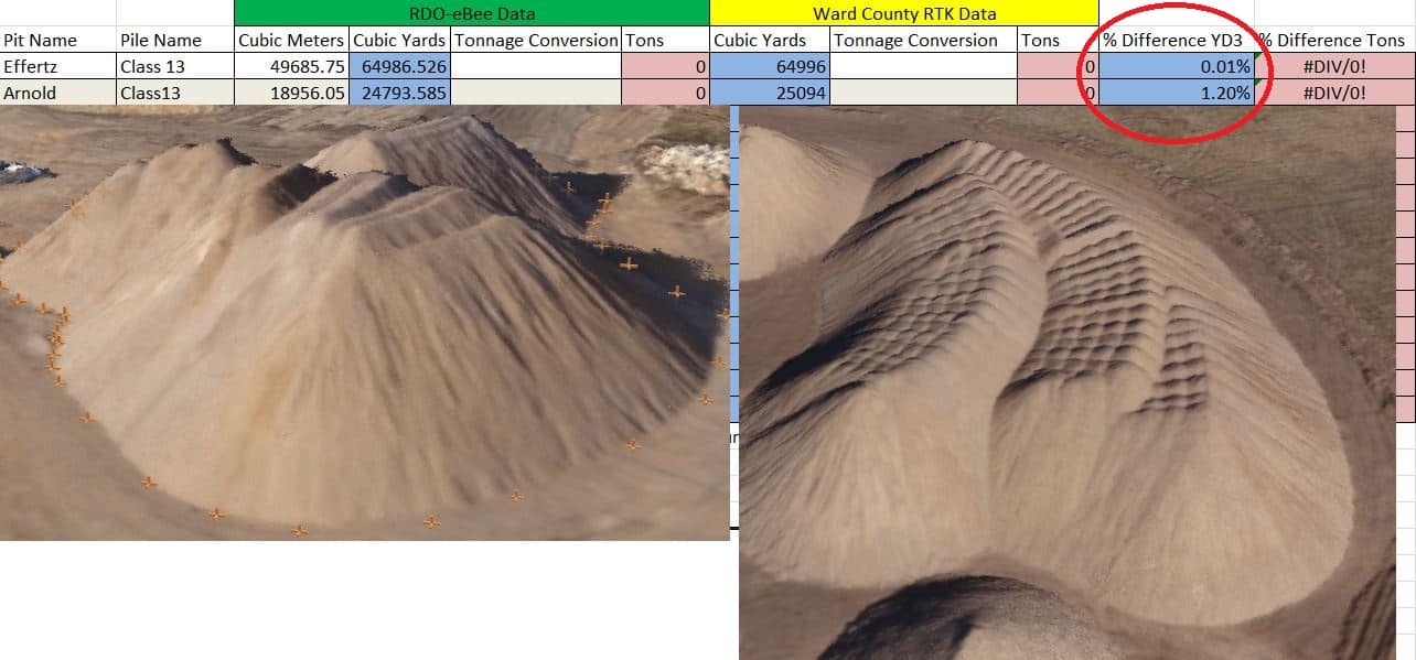
Full warning im actual a re-seller of the product but i have been doing testing. Comparing LIDAR,RTK and scanning data compare to a standard eBee.
it is hard to compare RTK because of the the different variables(mostly human) but what i have found is when comparing to a data set that actually looks like the operator did a decent job shooting the pile is within 1% difference. Lidar was under 0.5% tolerance but it was a terrestrial scanner so only line of site the pile they used it on had a couple of anomalies on the top of the pile that didn't show up in the point cloud.I will soon be doing a comparison demo with Aerial LiDAR but do not have any data yet.
The app that uses photogrammetry is line of site so for taller piles that may have hidden ridges i would not use it.
To answer the OP original question if you use a UAV like the eBee and process in Pix4D for every volume you obtain the software will automatically calculate a +/- error for the associated pile this may be something worth looking into.
Posted : October 30, 2015 1:17 pm
Translate
▼
English
Spanish
French
German
Italian
Portuguese
Russian
Chinese
Japanese
Korean
Arabic
Hindi
Dutch
Polish
Turkish
Vietnamese
Thai
Swedish
Danish
Finnish
Norwegian
Czech
Hungarian
Romanian
Greek
Hebrew
Indonesian
Malay
Ukrainian
Bulgarian
Croatian
Slovak
Slovenian
Serbian
Lithuanian
Latvian
Estonian
Would love to see some video's uploaded that show what your doing with the eBee/Pix4D.
Fascinating stuff. I think this is something that quite a few surveyors could branch out to.
The more they are exposed to the technology, the sooner they will move that direction.
Posted : October 30, 2015 3:26 pm

Translate
▼
English
Spanish
French
German
Italian
Portuguese
Russian
Chinese
Japanese
Korean
Arabic
Hindi
Dutch
Polish
Turkish
Vietnamese
Thai
Swedish
Danish
Finnish
Norwegian
Czech
Hungarian
Romanian
Greek
Hebrew
Indonesian
Malay
Ukrainian
Bulgarian
Croatian
Slovak
Slovenian
Serbian
Lithuanian
Latvian
Estonian
This image shows one of the problems we encounter when reporting volumes.
The grader/trucking company ALWAYS disagrees with your numbers.
Don't know who to credit for the image but it may have come from this forum.
Posted : November 4, 2015 1:17 pm
Translate
▼
English
Spanish
French
German
Italian
Portuguese
Russian
Chinese
Japanese
Korean
Arabic
Hindi
Dutch
Polish
Turkish
Vietnamese
Thai
Swedish
Danish
Finnish
Norwegian
Czech
Hungarian
Romanian
Greek
Hebrew
Indonesian
Malay
Ukrainian
Bulgarian
Croatian
Slovak
Slovenian
Serbian
Lithuanian
Latvian
Estonian
I researched this back in the early 1970's. The published research in Photogrammetric Engineering journal shows the industry standard of accuracy at 2% of actual volume when flown at 1500 feet above ground level and contoured at a one-foot contour interval. I would expect equivalent accuracy with UAV flights if the volume determination is performed by an experienced photogrammetrist (manually working) in stereo.
Using just software and "automatic correlation" to produce a resultant work product? Beats me what you get. I would prefer to trust human judgement than a purely mechanical process; especially if you're going to stake your reputation on the result.
Posted : November 5, 2015 11:00 am