I hate to harp on this...okay, maybe NOT!
What is so frick'n difficult about DATUMS and the DIFFERENCE Between WGS84(Gwhatever) and NAD83(whatever), that so baffles Land Surveyors?
I have been asked to "look at" about half a dozen "surveys" this last year, in which the "professional" Land Surveyor has furnished the client with WGS84 values, that are OBVIOUSLY NAD83 values. I got one this morning, that has NAD27 UTMs and "WGS84 UTMS" on an NGS "Federal Base Network Control Station," scaled to US Feet, and not only is the "WGS84" value in fact a NAD83 value, but the NAD27 value is wrong by about 3 feet (this station has a "superseded" NAD27 Lat/Lon).
Why can't [some] surveyors get their (pointy little) head around the simple fact that WGS84 does NOT equal NAD83 (and vice versa), and hasn't for over 25 years!
I have concluded that not all of the "button pushing morons" are technicians out in the field.
😡
Loyal
I know, I know.
The problems are some computer programs. They use WGS84 interchangeably with NAD83.
I have one of them, when you look at a readout one of the lines says the LAT, LONG is WGS84 even though it's really NAD83.
Soooo, it gets listed that way.
And I also know what's going on with the NAD27 number. It was shifted from what was thought of as being WGS84 and it was actually NAD83, that plus the fact that you can't really get the real 27 number from shifting creates the 3'.
To me a NAD27 coordinate has to be surveyed from known NAD27 monuments, and if it already has a 27 number, then,,,,,,,,,,,,
It's pretty bad to give out a 27 number that doesn't match the published one 🙁
Loyal, post: 448353, member: 228 wrote: I hate to harp on this...okay, maybe NOT!
What is so frick'n difficult about DATUMS and the DIFFERENCE Between WGS84(Gwhatever) and NAD83(whatever), that so baffles Land Surveyors?
I have been asked to "look at" about half a dozen "surveys" this last year, in which the "professional" Land Surveyor has furnished the client with WGS84 values, that are OBVIOUSLY NAD83 values. I got one this morning, that has NAD27 UTMs and "WGS84 UTMS" on an NGS "Federal Base Network Control Station," scaled to US Feet, and not only is the "WGS84" value in fact a NAD83 value, but the NAD27 value is wrong by about 3 feet (this station has a "superseded" NAD27 Lat/Lon).
Why can't [some] surveyors get their (pointy little) head around the simple fact that WGS84 does NOT equal NAD83 (and vice versa), and hasn't for over 25 years!
I have concluded that not all of the "button pushing morons" are technicians out in the field.
😡
Loyal
It all started when some dimwit named a datum and an ellipsoid the same thing. All dowhill after that...
Seriously, I have had to show network operators they werent on WGS84. 2022 can't get here fast enough.
thebionicman, post: 448358, member: 8136 wrote: It all started when some dimwit named a datum and an ellipsoid the same thing. All dowhill after that...
Seriously, I have had to show network operators they werent on WGS84. 2022 can't get here fast enough.
"2022 can't get here fast enough."
Can you elaborate on your thoughts on this? (Perhaps you should start a new thread.) I'm sure that once 2022 gets here we will have clients that want NAD83 and 2022 data, possibly even NAD27, NAD 83 and 2022 data for the same points! I think we will have even more issues then - I will be relaxing on a beach somewhere (aka retired), but I will be following things here to see if all our problems are resolved 🙂
Jim in AZ, post: 448359, member: 249 wrote: "2022 can't get here fast enough."
Can you elaborate on your thoughts on this? (Perhaps you should start a new thread.) I'm sure that once 2022 gets here we will have clients that want NAD83 and 2022 data, possibly even NAD27, NAD 83 and 2022 data for the same points! I think we will have even more issues then - I will be relaxing on a beach somewhere (aka retired), but I will be following things here to see if all our problems are resolved 🙂
Im hoping the added complexity will cause some to either read a book or quit...
thebionicman, post: 448362, member: 8136 wrote: Im hoping the added complexity
Yeah, I'm hoping that the software developers will be able to properly implement NSRS 2022 time dependencies by 2032!
A lot of things have to change at the core before ArcGIS and AutoCAD and other geospatial software are able to cope with a 4th dimension.
JKinAK, post: 448367, member: 7219 wrote: Yeah, I'm hoping that the software developers will be able to properly implement NSRS 2022 time dependencies by 2032!
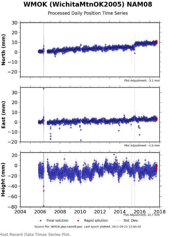
The time dependent element of NAD83 and NATRF2022 are really only present for those of us where the North American plate fixed reference system (with Euler pole rotation) doesn't work well, basically the west coast of CONUS and Alaska (Western Canada too, I suppose). Although it appears now that they will, at one time NGS wasn't even sure they would provide a dynamic datum model (HTDP or the next generation) with NATRF2022. I very seriously doubt software developers will be incorporating a time dependent velocity model into their products just for us "left coasters" any time soon, if ever.
Here is the time series plot for the lone PBO station in Oklahoma. There basically is no time dependent positional component. Same will be true for NATRF2022.
thebionicman, post: 448362, member: 8136 wrote: Im hoping the added complexity will cause some to either read a book or quit...
ROFLMAO!!!
When the new 2022 system arrives, will each state have to pass a new law establishing the "(fill in state name) Coordinate System 2022"? Will they again have to pass laws about whether the unit of distance used with the Coordinate System 2022 will be meters, survey feet, or international feet? Oh wait, lets use chains and links for horizontal measurements and fathoms for vertical measurements.
ashton, post: 448372, member: 422 wrote: When the new 2022 system arrives, will each state have to pass a new law establishing the "(fill in state name) Coordinate System 2022"? Will they again have to pass laws about whether the unit of distance used with the Coordinate System 2022 will be meters, survey feet, or international feet? Oh wait, lets use chains and links for horizontal measurements and fathoms for vertical measurements.
Oh man, I hope they don't pass any laws at all...Professional boards should govern these things as a matter of professional practice and standard of care. The fact that we would have to legislate it seems really sad, if it's actually true that our fellow practitioners need so much guidance and hand-holding.
I just finished moving all my corners 3 feet, it took months! And now you are telling me that in 5 years I will have to move them all AGAIN? :scream: 😉
And what about software not knowing the difference between inter.. feet and US. The struggle kills me
Sent from my iPhone using Tapatalk
FrozenNorth, post: 448373, member: 10219 wrote: Oh man, I hope they don't pass any laws at all...Professional boards should govern these things as a matter of professional practice and standard of care. The fact that we would have to legislate it seems really sad, if it's actually true that our fellow practitioners need so much guidance and hand-holding.
Oregon removed our coordinate systems for the Oregon Revised Statutes and place them under administrative rules. Now they can be changed by an appointed committee.
John Putnam, post: 448424, member: 1188 wrote: Oregon removed our coordinate systems for the Oregon Revised Statutes and place them under administrative rules. Now they can be changed by an appointed committee.
Well, that is better than the legislature messing with things they know nothing about. Then again, it all depends on the members of the "appointed committee" doesn't it? Maybe it won't be filled with engineers??
Here is a novel concept: Why not leave things like these to the profession and the professional societies, not the politicians and bureaucrats?
ORS places the creation of coordinate systems under ODOT administrative rules. The committee make up is required by statute to include both public and private surveyors and GIS types. It would be pretty damn hard for the state to inforce anything that was required by societies.
thebionicman, post: 448362, member: 8136 wrote: Im hoping the added complexity will cause some to either read a book or quit...
LOL... I wouldn't hold my breath on that. It hasn't bothered them enough for the last two decades. I agree; its staggering how many licensees I have worked closely with that have zero grasp of where the N, E, and Elev coordinates they rely upon every day actually came from. "From the magic GPS" is good enough to satisfy their minds enough to give it the stamp. I guess ignorance truly is bliss.
They don't know, they don't care, and they don't care to know. You can't change or fix that.
Reminds me of when I asked a field guy whether the elevations on stakes in my neighborhood were NGVD29 or NAVD88 and he replied that they do everything in NAD83.
Bill93, post: 448450, member: 87 wrote: Reminds me of when I asked a field guy whether the elevations on stakes in my neighborhood were NGVD29 or NAVD88 and he replied that they do everything in NAD83.
Yep. I've seen plans that said "Vertical Datum: NAD 83". Umm, no.
This is why Substantial control points should be set on the job site
so if the control points shift over years due to continental drift the control points are still correct relative to
each other
Most important
1) a control drawing showing coords with the datum and year "epoch"
.
And just localize
Oh well
One one 200 mill and another 800 mill job no control drawing what a joke just a couple rusty 8" spikes in a mud puddles
!@$@*$)$@ construction clowns.
Pete


