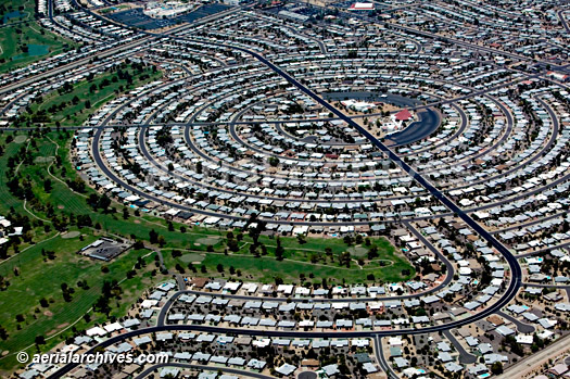
I wish someone could explain to me why it's good to design curves along the back lot lines in a subdivision... I'm dealing with two tears of lots that back up to each other and the "designer" has several different curves as the common rear lines. The rear lot corners are staggered as well. It doesn't seem professional to me to set the whole neighborhood up for future problems. Imagine the lot owners trying to fence along a curve.... while they aren't even sure which pin is theirs.
Me too. I also wonder why the ??designers? place a PC of a curve 0.18?? away from an intersection.?ÿ ??ÿ
No doubt the lot lines are non-radial as well..?
It's not good.?ÿ It's CAD.
?ÿ
computer cowboy,,,,,,,,,,,, and the?ÿPC .18' from the intersection,,,,,,,,ahhhhh!!!?ÿ?ÿ?ÿ it was simpler when plats were hand drawn, none of that stuff
computer cowboy,,,,,,,,,,,, and the?ÿPC .18' from the intersection,,,,,,,,ahhhhh!!!?ÿ?ÿ?ÿ it was simpler when plats were hand drawn, none of that stuff
It was smarter, logical and efficient too.?ÿ
I got ahold of a subdivision we're staking out.?ÿ Our engineer did the design in house, and this is the final phase of a several phase subdivision.?ÿ For some reason, and I don't think this was intentional, the new lot corners that backed up to the last phase were missing those corners by anywhere from 3 feet to 12 hundredths.?ÿ The final plat has not been produced yet, so I put a stop to that nonsense.
Guys, you're missing the point.
Don't you realize how much more aesthetically pleasing a smooth set of curves on a map appears as?ÿcompared to boring straight ziggity-zaggity lines?
?ÿ
?ÿ
?ÿ
?ÿ
?ÿ
?ÿ
?ÿ
?ÿ
?ÿ
?ÿ
Wendell, please bring back the sarcasm font.
Well said.
While it may be easier in CAD those almost coincident rear corners aren't anything new.?ÿ I've pored over a 1958 plat that has some corners less than a foot apart.?ÿ And for one rear line along several lots the two sides?ÿdon't add up the same by 0.9 ft.
Without CAD back then, curves weren't used unnecessarily, but some of them on streets neither check among the parameters given nor fit in the space left by the lot dimensions.
Computers just let us make mistakes or poor decisions faster.
River Oaks (swanky part of town) here in Houston. Curved rear property lines, drafted back in the day. Good solid original monuments - if you aren't afraid of digging - the plat is a head scratcher though.
Here's a goody from 1897.?ÿ It's pretty for a hundred and twenty year old design, but nearly impossible to put on the ground.?ÿ The city has been reworking sidewalks, alleys and utilities so there's very little left to work with.
Edit: Whoops, that file is a compressed 2.5 mb tiff and when I try to crop or resize it I end up with a 25-30 mb file.
Idiots are everywhere.
Had a land owner on a project a few years back. The RW take off the back of his lot was to be?ÿon the out side of a curve. 1200 meter centerline radius-?ÿwith about a 38 meter offset. State plane job. He wouldn't agree to the curved line. Required it to be a straight take across him- his reasoning- he didn't want to have a curved fence to maintain. Seemed like a pretty reasonable request to me...
Several years ago, a tech was working on a tract that had a creek boundary on the west end of the property.
When I looked at his work, he had computed a curve for the water boundary.........nope, nope, nope.
Idiots are everywhere.
Stop picking on me.?ÿ ??ÿ
.. Then there's the lot in a subdivision, which calls for the rear boundary to be a contour line 10' above a certain body of water - with respect to a benchmark in the subdivision listed on the plat.
Having worked in the PNW for most of my career, where we have these things called "hills" which often require that lots and streets be oriented to the lay of the land to be buildable, I find curved lot lines, wherever they may be, to be just a fact of life.?ÿ?ÿ
It's called coving...

?ÿ

Pathetic.


