Reading RPLS is free for the whole profession. Members post, reply, and get the members-only rooms.


Notifications
Clear all

Topic starter
Translate
▼
English
Spanish
French
German
Italian
Portuguese
Russian
Chinese
Japanese
Korean
Arabic
Hindi
Dutch
Polish
Turkish
Vietnamese
Thai
Swedish
Danish
Finnish
Norwegian
Czech
Hungarian
Romanian
Greek
Hebrew
Indonesian
Malay
Ukrainian
Bulgarian
Croatian
Slovak
Slovenian
Serbian
Lithuanian
Latvian
Estonian
I get contacted by architects after sending them a survey drawing in Cad complaining that they cant run the flatten command properly in Autocad as the point blocks will not go to zero.
I was thinking of running the block explode in Carlson each time before sending a drawing off so that the user has the option of flattening or not. My question is what is the disadvantage of doing this? What good reasons are there to retain the points as blocks?
Posted : October 17, 2016 1:33 pm

Translate
▼
English
Spanish
French
German
Italian
Portuguese
Russian
Chinese
Japanese
Korean
Arabic
Hindi
Dutch
Polish
Turkish
Vietnamese
Thai
Swedish
Danish
Finnish
Norwegian
Czech
Hungarian
Romanian
Greek
Hebrew
Indonesian
Malay
Ukrainian
Bulgarian
Croatian
Slovak
Slovenian
Serbian
Lithuanian
Latvian
Estonian
Would be easier to redraw all of the points and un-check "Place on real z axis", then they'll already be at "0". Exploding all of the points would work, but makes for a lot of clutter.
Posted : October 17, 2016 1:38 pm
Topic starter
Translate
▼
English
Spanish
French
German
Italian
Portuguese
Russian
Chinese
Japanese
Korean
Arabic
Hindi
Dutch
Polish
Turkish
Vietnamese
Thai
Swedish
Danish
Finnish
Norwegian
Czech
Hungarian
Romanian
Greek
Hebrew
Indonesian
Malay
Ukrainian
Bulgarian
Croatian
Slovak
Slovenian
Serbian
Lithuanian
Latvian
Estonian
Plumb Bill, post: 395607, member: 226 wrote: Would be easier to redraw all of the points and un-check "Place on real z axis", then they'll already be at "0". Exploding all of the points would work, but makes for a lot of clutter.
I prefer to send out a 3d drawing and the end user can then decide if they want to make it 2d or not. Unchecking the place on real z axis makes it always 2d. Not sure how it makes it more clutter, when I run it here I just end up with same as before other than the blocks are individual entities.
Posted : October 17, 2016 1:54 pm

Translate
▼
English
Spanish
French
German
Italian
Portuguese
Russian
Chinese
Japanese
Korean
Arabic
Hindi
Dutch
Polish
Turkish
Vietnamese
Thai
Swedish
Danish
Finnish
Norwegian
Czech
Hungarian
Romanian
Greek
Hebrew
Indonesian
Malay
Ukrainian
Bulgarian
Croatian
Slovak
Slovenian
Serbian
Lithuanian
Latvian
Estonian
I use Carlson as well, and have had some clients make the same comment. However one of my general rules is to: "Never explode anything, unless absolutely sure of all of the ramifications, and in that case rarely explode anything." But when I talk to my coworkers about it, it is just "Never explode".
Personally I would look for another way, and if I exhausted that effort, I may do it. But that is just me....
If you are doing it in a separate file that is only to be delivered to your client and not used in-house, then that may be the 'unless rarely'.
Posted : October 17, 2016 3:53 pm

Translate
▼
English
Spanish
French
German
Italian
Portuguese
Russian
Chinese
Japanese
Korean
Arabic
Hindi
Dutch
Polish
Turkish
Vietnamese
Thai
Swedish
Danish
Finnish
Norwegian
Czech
Hungarian
Romanian
Greek
Hebrew
Indonesian
Malay
Ukrainian
Bulgarian
Croatian
Slovak
Slovenian
Serbian
Lithuanian
Latvian
Estonian
I usually draw points in 2d with point number, elevation and description. If a client wants to plot in 3d, he gets an ASCII file
Posted : October 17, 2016 9:49 pm
Topic starter
Translate
▼
English
Spanish
French
German
Italian
Portuguese
Russian
Chinese
Japanese
Korean
Arabic
Hindi
Dutch
Polish
Turkish
Vietnamese
Thai
Swedish
Danish
Finnish
Norwegian
Czech
Hungarian
Romanian
Greek
Hebrew
Indonesian
Malay
Ukrainian
Bulgarian
Croatian
Slovak
Slovenian
Serbian
Lithuanian
Latvian
Estonian
billvhill, post: 395669, member: 8398 wrote: I usually draw points in 2d with point number, elevation and description. If a client wants to plot in 3d, he gets an ASCII file
Does that not negate any clean up you may have done in the drawing? What about contours, many of my clients require 3D contours for Revit.
My question in the original post is what are the disadvantages to not having the points as blocks. Any Carlson people out there...
Posted : October 18, 2016 1:46 am
Translate
▼
English
Spanish
French
German
Italian
Portuguese
Russian
Chinese
Japanese
Korean
Arabic
Hindi
Dutch
Polish
Turkish
Vietnamese
Thai
Swedish
Danish
Finnish
Norwegian
Czech
Hungarian
Romanian
Greek
Hebrew
Indonesian
Malay
Ukrainian
Bulgarian
Croatian
Slovak
Slovenian
Serbian
Lithuanian
Latvian
Estonian
I don't use Carlson any more, but I think the obvious disadvantage is that the points would no longer be points. I don't know what the exploded entity becomes. I recently was working with a survey where the "points" were a "+" text entity, with text entities for the number, description, and elevation. I personally think that looks like crap and gives it an unprofessional look. On the other hand, is the architect even able to do anything with Carlson points to begin with? If they're using Revit, I doubt that it even recognizes Carlson points as points. Which brings up the question I've had since reading your original post: What is the architect planning on doing with the points? I've never known any architect who cares about having points. It's hard enough getting them to respect the boundary and easements, much less care about points. Do you perhaps use your point blocks as symbols? To me there are too many unknowns to really answer your question.
Personally, I like Plumb Bill's suggestion to redraw the points at elevation 0. I don't use the flatten command, so I don't know why it wouldn't put Carlson points at 0, but perhaps they could try an old school elevation change. Select all the point blocks, use -ch at the command line, go to properties, then elevation, and set them all to 0. That's what I would try.
What I still don't understand though, if they are using Revit, is why they would flatten everything. I've never used it, but my impression would be that you would want 3d entities for that, and if that's true, then why flatten entities? I only bring this up because of your last post saying that your clients require 3D contours for Revit. I only bring that up because I also like billvhill's answer. I know it's personal preference, but that's what I like to do also, if it's up to me. My year and a half working with Carlson I had a boss who liked her points at elevation so I did that on all the projects at that company, but speaking Civil 3D (and I know we aren't), the actual elevation of the point marker does not matter. Civil 3D knows what the elevation of the point is, so having the marker at 0 doesn't make any difference, even when it comes to things such as surface modeling. I don't know if the same logic applies to Carlson.
Posted : October 18, 2016 5:51 am

Translate
▼
English
Spanish
French
German
Italian
Portuguese
Russian
Chinese
Japanese
Korean
Arabic
Hindi
Dutch
Polish
Turkish
Vietnamese
Thai
Swedish
Danish
Finnish
Norwegian
Czech
Hungarian
Romanian
Greek
Hebrew
Indonesian
Malay
Ukrainian
Bulgarian
Croatian
Slovak
Slovenian
Serbian
Lithuanian
Latvian
Estonian
Totalsurv, post: 395680, member: 8202 wrote: Does that not negate any clean up you may have done in the drawing? What about contours, many of my clients require 3D contours for Revit.
My question in the original post is what are the disadvantages to not having the points as blocks. Any Carlson people out there...
You can easily contour in Carlson without having points on Real Z.
In my opinion, there's no value in having points on elevation, but the draw-backs are numerous.
Posted : October 20, 2016 8:30 am

Translate
▼
English
Spanish
French
German
Italian
Portuguese
Russian
Chinese
Japanese
Korean
Arabic
Hindi
Dutch
Polish
Turkish
Vietnamese
Thai
Swedish
Danish
Finnish
Norwegian
Czech
Hungarian
Romanian
Greek
Hebrew
Indonesian
Malay
Ukrainian
Bulgarian
Croatian
Slovak
Slovenian
Serbian
Lithuanian
Latvian
Estonian
JPH, post: 396138, member: 6636 wrote: You can easily contour in Carlson without having points on Real Z.
In my opinion, there's no value in having points on elevation, but the draw-backs are numerous.
I agree. I hate running "Standard Distance" between points hundreths apart and getting the slope distance instead of horizontal.
Posted : October 20, 2016 9:13 am

Translate
▼
English
Spanish
French
German
Italian
Portuguese
Russian
Chinese
Japanese
Korean
Arabic
Hindi
Dutch
Polish
Turkish
Vietnamese
Thai
Swedish
Danish
Finnish
Norwegian
Czech
Hungarian
Romanian
Greek
Hebrew
Indonesian
Malay
Ukrainian
Bulgarian
Croatian
Slovak
Slovenian
Serbian
Lithuanian
Latvian
Estonian
I can not come up with any particular disadvantage to exploding the blocks before you send it out. I might want to rename the file so that it does not get mixed up with my working file. There is a command in the "Points/Convert Point Format/Explode Carlson Points". Some of the Carlson commands will no longer work with the point block exploded but it is easy enough to redraw the points and restore the blocks.
Posted : October 21, 2016 10:40 am

Translate
▼
English
Spanish
French
German
Italian
Portuguese
Russian
Chinese
Japanese
Korean
Arabic
Hindi
Dutch
Polish
Turkish
Vietnamese
Thai
Swedish
Danish
Finnish
Norwegian
Czech
Hungarian
Romanian
Greek
Hebrew
Indonesian
Malay
Ukrainian
Bulgarian
Croatian
Slovak
Slovenian
Serbian
Lithuanian
Latvian
Estonian
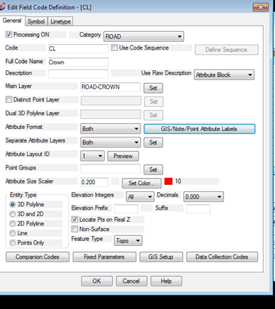
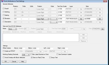
Try setting up F2F and select GIS Note/Point Atribute Labels, you can end up with Carlson Points and Text on different layers
Posted : October 23, 2016 6:43 pm