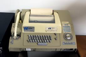
I had an HP9815 I used for years (similar to your photo). I also use to depend heavily on a dos based program called "CEAL" I believe it was 'Civil Engineering Analytical Library'. Late '80s, it was the first software I ever used that could calc and store an entire subdivision's cogo. Fantastic. We still had huge sheets of grid paper we drew on...and the plats were all hand drawn still. But it was so much easier than that Wang!
paden cash, post: 385123, member: 20 wrote: I had an HP9815 I used for years (similar to your photo). I also use to depend heavily on a dos based program called "CEAL" I believe it was 'Civil Engineering Analytical Library'. Late '80s, it was the first software I ever used that could calc and store an entire subdivision's cogo. Fantastic. We still had huge sheets of grid paper we drew on...and the plats were all hand drawn still. But it was so much easier than that Wang!
Yep ..grid paper....HP 35 ....and Soh Cah Toa (Law of Sines)
FL/GA PLS., post: 385119, member: 379 wrote: invention of the Wang 2200 system
I worked for a guy that had a pen plotter; it was a big table, probably 4' x 8'; it had an arm across the 4' width, that ran up and down the length of the table; a pen holder, connected to the arm, would plot an x and the point number to a piece of paper held to the table with magnets. You kept hand notes; hz angle, z angle, and slope dist. You would hand enter into a cogo program that created the coordinates.
This was your work sheet, mainly for topo. You connected the dots, then overlaid it with velum to produce the final draft.
We've come along way in 40 years...
not my real name, post: 385109, member: 8199 wrote: Dear Peter,
Can't you tell where I am from the picture that I use as my avatar? 🙂
Well, I can tell you that I am from New England. That's probably nowhere
near any one else. Most everyone here seems to be out west.I thought the replies given on my question were very good. Thank you everyone
for the effort.
I just had a better look at your avatar photo... that appears to be the lagoon behind my house. I had no idea we were neighbors! 😉
===
back on topic: the HP3800 was an awesome instrument. If we had enough glass we could shoot 18,000 feet (but the atmospheric corrections only applied to the Displayed distance that maxed at 9,999 ... we learned to set corrections to Zero and made the corrections in the office)
accuracy was as good as it gets, probably better then the best of RTK
I started surveying in late in 1974. We could chain around 8,000 feet and get within 0.2 ft. We would check our chaining with a Model 8 and turn angles with a T-2. Some control shot with the Model 8 we would use three triple-glass. Angles would be picked up by shinning the sun against the prisms with a mirror. In the office we used a Wang. Seemed like a marvel at the time. Those we some of the best days surveying for me. Maybe I was just young and didn't know any better.
You know, nothing has really changed except the tools. The cos of the bearing times the distance will still produce a difference in northings..and the sin of the bearing times the distance will still yield a difference in eastings. The package might have changed a great deal but the recipe has been the same since Pythagoras first picked his nose.
paden cash, post: 385132, member: 20 wrote: You know, nothing has really changed except the tools.
Except that these tools now make ALL the calculations on the fly...
Lickety split
paden cash, post: 385132, member: 20 wrote: You know, nothing has really changed except the tools. The cos of the bearing times the distance will still produce a difference in northings..and the sin of the bearing times the distance will still yield a difference in eastings. The package might have changed a great deal but the recipe has been the same since Pythagoras first picked his nose.
The big difference is most of us oldtimers could still calculate those triangles with pencil paper and the sine tables from the back of a FB
paden cash, post: 385123, member: 20 wrote: I had an HP9815 I used for years (similar to your photo)
Prior to the HP we manually "programmed" the beast below with tickertape than dialed up the server and let 'er rip. The closures would start coming immediately on roll paper in the contraption. I thought I was WAAAY cool while on that thing.
Dad bought a T-1 with the DI-3 in the early 70's, then later got the T-2 with the DI-10. this was in the Mid Hudson Valley.
Michael Platt, post: 385140, member: 10797 wrote: The big difference is most of us oldtimers could still calculate those triangles with pencil paper and the sine tables from the back of a FB
I get phone calls from my PCs with problems locating search areas and the like. I have an old HP11C sitting here and can give my crew a vector to go "look" quicker than they can with their data collector.
It's not rocket surgery....;)
FL/GA PLS., post: 385119, member: 379 wrote: We used the equipment I posted above(10 sets) to survey the 115,000 ac. of what is now known as Palm Coast, Fl. If we didn't have a closure of 1:100,000 per "leg" of traverse, that leg of a huge network system was re-run until it did.
We reduced notes on an electronic marvel at the time known as a HP9810. You could program it and save your program on magnetic strips about 3" x 7" that went into a slot in the upper right hand portion of the machine.
A few years later a significant breakthrough occurred with the invention of the Wang 2200 system running Houlgin (sp?) software called CEADS.
Cripes am I old! 😎
If I remember correctly you could store about 50 coordinate pairs per card...
A Harris, post: 385084, member: 81 wrote: Believe it or not, some people did learn to use antiquated equipment to measure very accurately.
I was on the crew that retraced several hundred acres of land that Steven F. Austin had surveyed in Wood County. All we found were the witness trees and Everything worked out less than a foot different than called information.
😎
I spent a lot of time recovering monuments in a town that was laid out in 1967. I was told it was steel chain and transit work and that the guy in charge was very meticulous.
I had an Autocad drawing of the entire town, which was compiled strictly from record. Most all of the search locations would land on the top of a pipe.
Very impressed with their work. There were occasional blunders, but otherwise it was hot.
Transit & chaining a network (as in lots in subdivision) is probably a lost art. A good example would be a block of lots that was essentially a rectangle. If each block end was properly measured and established, the intermediate pins could be set with good line work with a high level of confidence that the pins measured correctly between one another.
J. Penry, post: 385077, member: 321 wrote: I used a T-2 with a top mounted Red Mini in 1984. Total stations were becoming more available, but not yet widespread. First total station I used was a Lietz SET-10. Measured in slope distances and you had to record the vertical angle to get the horizontal distance. The State was using some EDM's earlier, but I don't know of any private surveyor using them in the 1970's around here.
I too began using a Red Mini in 1984.
not my real name: you asked several questions;
1. "Was there electronic distance measurement (EDM) devices in 1974". answer: YES
2. "Any idea on what would have been the time of the first instance of EDM use for surveyors in practice". answer: as soon as the EDMI
starting hitting the market the surveyor started getting them.
Model 4 Geodimeter year 1959 ( I bought one from a private surveyor in California in circa 1990. He got it when it first came out).
Tellurometer MRA 1 year 1957
Tellurometer MA 100 year 1963 ( something like $4,000.00)
HP 3800 year 1969 (Its cost was a little over $4,000.00
Wild DI 10 Distomat year 1969
And for the Big Boys with a lot of tax payers money (Govt. agencies)
Model 1 and several years later the Model 2 Geodimeter, year 1953, 1955 ($25,000)
JOHN NOLTON
FL/GA PLS., post: 385070, member: 379 wrote: I "cut my teeth" on these wonders of technology in 1971
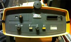
HP 3800
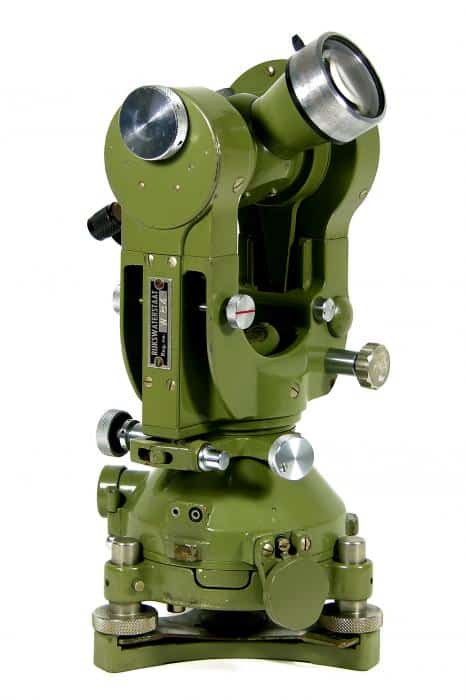
Wild T-2
FL/GA PLS The picture you show of the EDMI IS NOT A HP 3800. The HP 3800 was gray in color.
I don't think its a HP 3808 either. Might be a HP 3810 ?
Can you tell us what HP it is ?
Thank You.
JOHN NOLTON
JOHN NOLTON, post: 385174, member: 225 wrote: FL/GA PLS The picture you show of the EDMI IS NOT A HP 3800. The HP 3800 was gray in color.
I don't think its a HP 3808 either. Might be a HP 3810 ?
Can you tell us what HP it is ?
Thank You.
JOHN NOLTON
You're correct. The 3800 was the gray box with the knobs. The one in the pic was an HP3805A. Came out right before the 3810A "Total Station", but wa sjust a second gen distance "meter" with upgraded LED display I think, but it still had that signal meter.
JOHN NOLTON, post: 385174, member: 225 wrote: Can you tell us what HP it is ?
Paden nailed it. I just grabbed the first picture I saw.
The big improvement with the 3805 was the onboard battery. You did not have to carry the motorcycle type battery separately. At least that is what I liked about it.


