I would hope none of us need to be reminded how valuable some info on and old map can be.
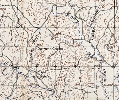
Although not really survey related, I came across a copy of a 1908-1909 quad sheet that had an interesting location noted: Daltons Caves.
When researching the Dalton boys in Oklahoma you have to be pretty specific. Some were lawless and rode with the Younger gang. Some were lawmen. Some were lawmen that turned to crime. There is a lot written about their escapades and sifting through fact and pulp fiction can be tedious. And I'm not even sure the name "Daltons Caves" has anything to do with the Dalton Gang. A brief internet search finds no mention of the location.
And the interesting thing is it is near a small town in Oklahoma that few historical references of the lawless Daltons mention. BUT the Dalton boys did live there for a period of time.
I may turn treasure hunter here shortly. 😉
Looks like great terrain for outlaws.
"OLD" USGS Quad Sheets and "special maps" are a MUST HAVE resource for most of my work. Some of the information contained in these maps can make the difference between looking in the RIGHT PLACE, or wasting your time in the WRONG PLACE. The iGage ALL-TOPO Map sets with the "Historical Collection," is da bomb! By pressing the F9 key when you are looking at an area (any scale), a pop-up lists all of the other maps that cover that area.
Somewhat like having a Time Machine on your computer.
Loyal
paden cash, post: 404299, member: 20 wrote: I would hope none of us need to be reminded how valuable some info on and old map can be.
I may turn treasure hunter here shortly. 😉
Around here, the old quads from that era and some a few decades later had symbols locations for Indian mounds and other sites.
They were eventually removed from the later maps because of treasure and artifact hunters.
An important name from the early days of Skiatook , Oklahoma was Augustus (Auguste) (Ogeese) Captain. He came from Osage Mission (now St. Paul), Kansas. A couple of miles west of St. Paul is where Ogeese Creek meets the Neosho River. The locals somehow decided the correct spelling of the French name Auguste, should be Ogeese.
Old quad maps are works of art, done with planetable
The last company I worked for was MJ Harden, Associates. A photogrammetric mapping company.
Milton J Harden founded the company in 1957 after concluding a career with the US government, lastly with the Tennessee Valley Authority. Earlier he had been an employee of the USGS.
Milton J Harden's name appears on many USGS 15 minute quadrangles. He was a plane table operator. Sadly, in my collection of 50 or so of these works of art, I do not own any with his name. When our company shut its doors a few years back, the ones having his name went, rightly so, to his family.
Holy Cow, post: 404569, member: 50 wrote: An important name from the early days of Skiatook , Oklahoma was Augustus (Auguste) (Ogeese) Captain. He came from Osage Mission (now St. Paul), Kansas. A couple of miles west of St. Paul is where Ogeese Creek meets the Neosho River. The locals somehow decided the correct spelling of the French name Auguste, should be Ogeese.
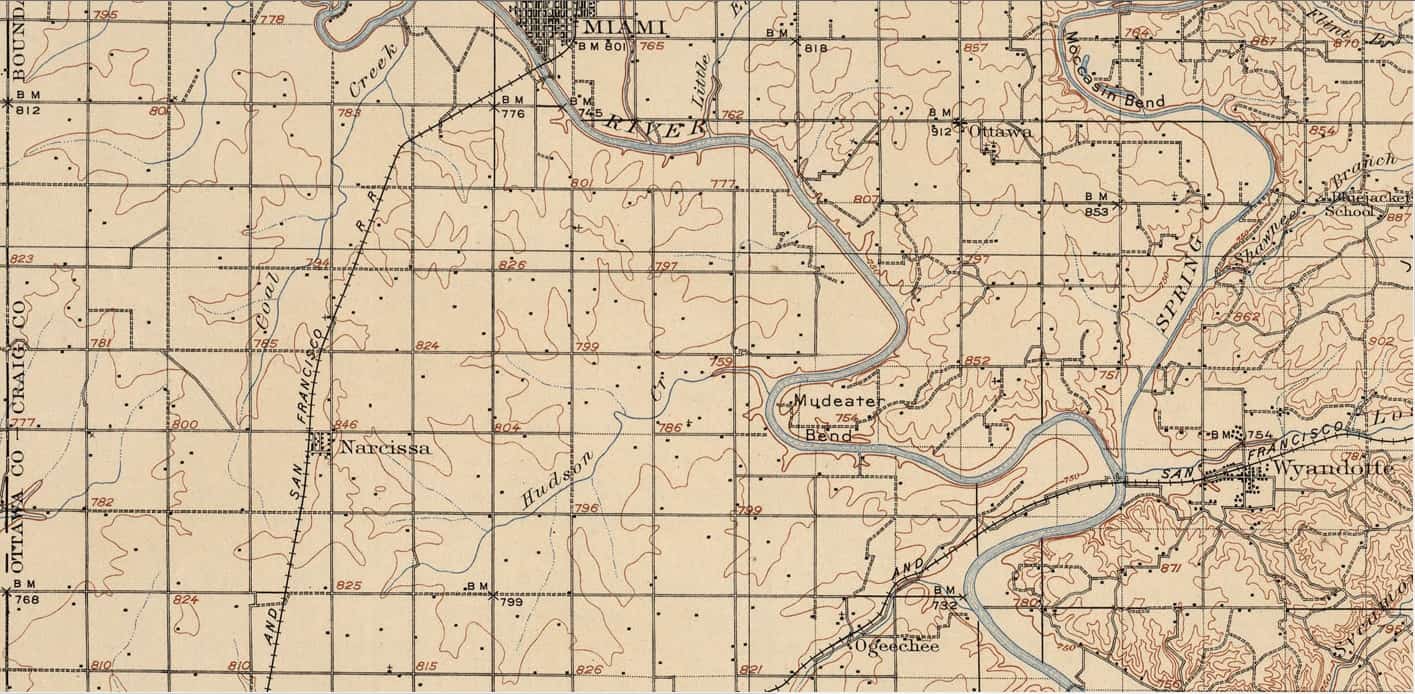
Here's one from your neck of the woods. Note the Neosho takes a course around "Mudeater Bend".
One quickly sees the melting pot of Indian influence in that region. Ottawa, Miami, Shawnee and Wyandotte all appear. I'm pretty sure that Ogeechee wasn't named after an Irishman, either.
What great alternatives. Mudeater or Moccasin Bend to select as your new residence.
I did a good amount of surveying at the school in Chilocco in '92 and '93. The school had been closed due to no more of Uncle Sam's money. At that time the maintenance and ownership was being shared by a number of Tribes, none apparently really interested in keeping the place up due to funding. This was "B.C."....before casinos.
The place was really nice and surely full of history. I think the only thing that was there at that time was a drug and alcohol treatment center that only occupied two or three of the buildings. I hope the place hasn't fallen into disrepair.
There's a heap of time from 1892 to now, and you have to be smarter than everyone that lived and looked before you. No disrespect intended, but that's a high bar to jump.
That's if no one found it before now and kept their mouth shut.
wfwenzel, post: 404908, member: 7180 wrote: There's a heap of time from 1892 to now, and you have to be smarter than everyone that lived and looked before you. No disrespect intended, but that's a high bar to jump. That's if no one found it before now and kept their mouth shut.
The two chances of finding a stash from some of the notorious outlaws are slim and none. I believe it was Ben Franklin that said "Three people can keep a secret if two of them are dead". I'm real sure that probably applied to any 'reserved' treasure any of the Daltons or Youngers attempted to hide.
And the reality is 100 years can waste anything that is not sealed up tight. I've read that most of their hauls were small and less than 1000 bucks. Bank notes were common. Any purloined gold or silver coinage was probably spent as fast as they could spend it.
A few years ago I found a notation on an 1874 GLO township plat (south of here near the Arbuckle Mountains) that stated "gold mine". I stopped by there when I was in the area thinking I was probably the first person in 125 years to see that info. The road to the site was well barb-wired shut with PLENTY of "NO TRESPASSING" signs with one old weathered sign painted on a pine 1x12 "No gold mine hear". And really spelled like that...
I chatted with a property owner down the road. The old man that had owned the 'site' for years had passed away but apparently endured nosy folks for years. The neighbor said everything would be quiet for a few years and then an article would get published in some "Treasure Hunting" magazine and the flurry of cars would continue for months. The story was that the 'site' bore more a resemblance to someone attempting to dig a well than a gold mine.
Probably some surveyor in 1874 with a sense of humor...;)
Narcissa. Old Rt. 66 went through there.
My family owns land in the Dalton Abstract in Lavaca County. There is a thicket (that was cleared a few months ago) where the Dalton gang supposedly hid out while they pillaged around here. I am always looking at the ground when I go out to that area....Story is a posse was going to get them, but they high-tailed it out of there before they got to them.
paden cash, post: 404919, member: 20 wrote: The two chances of finding a stash from some of the notorious outlaws are slim and none. I believe it was Ben Franklin that said "Three people can keep a secret if two of them are dead". I'm real sure that probably applied to any 'reserved' treasure any of the Daltons or Youngers attempted to hide.
And the reality is 100 years can waste anything that is not sealed up tight. I've read that most of their hauls were small and less than 1000 bucks. Bank notes were common. Any purloined gold or silver coinage was probably spent as fast as they could spend it.
A few years ago I found a notation on an 1874 GLO township plat (south of here near the Arbuckle Mountains) that stated "gold mine". I stopped by there when I was in the area thinking I was probably the first person in 125 years to see that info. The road to the site was well barb-wired shut with PLENTY of "NO TRESPASSING" signs with one old weathered sign painted on a pine 1x12 "No gold mine hear". And really spelled like that...
I chatted with a property owner down the road. The old man that had owned the 'site' for years had passed away but apparently endured nosy folks for years. The neighbor said everything would be quiet for a few years and then an article would get published in some "Treasure Hunting" magazine and the flurry of cars would continue for months. The story was that the 'site' bore more a resemblance to someone attempting to dig a well than a gold mine.
Probably some surveyor in 1874 with a sense of humor...;)
"Never P**s off a surveyor."
paden cash, post: 404299, member: 20 wrote: I would hope none of us need to be reminded how valuable some info on and old map can be.
Although not really survey related, I came across a copy of a 1908-1909 quad sheet that had an interesting location noted: Daltons Caves.
When researching the Dalton boys in Oklahoma you have to be pretty specific. Some were lawless and rode with the Younger gang. Some were lawmen. Some were lawmen that turned to crime. There is a lot written about their escapades and sifting through fact and pulp fiction can be tedious. And I'm not even sure the name "Daltons Caves" has anything to do with the Dalton Gang. A brief internet search finds no mention of the location.
And the interesting thing is it is near a small town in Oklahoma that few historical references of the lawless Daltons mention. BUT the Dalton boys did live there for a period of time.
I may turn treasure hunter here shortly. 😉
I gave away probably 150 old (1890s - 1920s) quad sheets when we moved. I had place to store them and didn't want them to just crumble away. I gave all my Florida quads to someone that you may remember from the "old" board. Pat May. All the others (Georgia, Alabama, Tennessee, North and South Carolina) went to a friend with SAMSOG to perhaps be auctioned for the educational fund. I only kept two. My favorite is the Knoxville, Tennessee quad dated 1916. It shows the Smoky Mountain National Park before it was a National Park.
Andy
I got maybe 70 some of the old ones for California and Nevada. Las Vegas is about 4 buildings at a crossroads.
Looking for a home; any ideas?
I came across a good quad map find. Working on a site map for Mount Rushmore, I pulled an early version 15 min. 1903, to compare with more recent maps. The words "Mt Rushmore" were in pencil in the margin with an arrow "to be added".
wfwenzel, post: 406666, member: 7180 wrote: I got maybe 70 some of the old ones for California and Nevada. Las Vegas is about 4 buildings at a crossroads.
Looking for a home; any ideas?
Ask UW's Robinson Map Library if they would like them? Or another local map library?


