We used the Bosch GLR 825 to quickly balance our turning points during a level run.
The party chief drove the truck, I measured a distance to it, and we adjusted the distance accordingly.
A great device for surveyors!
https://www.boschtools.com/us/en/boschtools-ocs/laser-measuring-glr-825-35119-p/
What's it cost?
I've used one for lots of things, but never been so lazy as to drive to my turn points. My average sight is 250', it would take longer to collapse the rod, get in the truck, drive to the point, get out of the truck, extend the rod, and then look for a suitable turn point. Pacing is another time saving device that costs nothing. No offense Field Dog, I'm sure there was a logical method to your madness.
That said, I did have my rod man strap on the rollerblades for a day on campus leveling between every mark we could see from one vantage point, then move ahead and repeat. Least squares project coupled with building our own local geoid model.
The Bosch model I have retails for under $100.
Nate The Surveyor, post: 376816, member: 291 wrote: What's it cost?
https://www.amazon.com/Bosch-GLR825-Laser-Distance-Measurer/dp/B003NSBG7C B-)
I'd have to agree with the pacing method, as mentioned above. The whole mob/demob-truck-shuttle never seemed to work at the short distances required.
Reminded me of a level loop ran not too long back, where I was pacing the first distance, while simultaneously trying to do the math on the optimal distances, given the length of the loop and number of turns, when I lost count of my pace, but figured, screw it, I know roughly the pace, and can adjust it pretty quick with a quick stadia reading. That was until I set up made the reading, and thought I lost my mind. I had never run an optical level with an SI constant. Scared the heck out of me.o.O
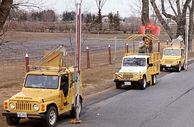
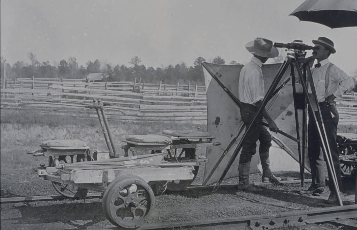
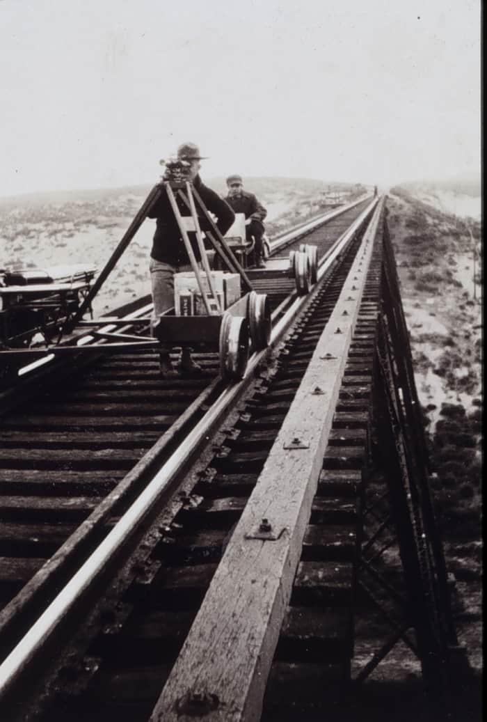
Here are some fun images of folks driving to the point. Both websites are well worth a look.
Height and Gravity :
1983 ÛÒ 1987 : Motorized Levelling
Experience in Sweden indicated that motorized precise levelling could be very productive. In 1981 and 1982 a prototype system was built and tested, featuring three four-wheel drive vehicles. Production work was started in 1983 with the system equipped with an automated data recording system. After early development problems had been solved, the unit's greater productivity in comparison with levelling on foot (about 40 percent) soon became apparent. Despite increased productivity, the original motorized levelling system was retired in 1987 following unsuccessful attempts at privatization and commercialization. 
http://www.photolib.noaa.gov/index.html
W. H. Burger observing. Note standing straight up to observe - minimizing fatigue. Level crew of W. H. Burger
Image ID: theb1758, NOAA's Historic Coast & Geodetic Survey (C&GS) Collection
Location: Texas, Area near Pittsburg
Photo Date: 1902
Credit: NOAA, John Hayford Album
Category: Geodesy/Leveling/Getting There/Velocipede/
Observing from level mounted on velocipede. Level center-mounted on velocipede. Crossing trestle on Southern Pacific Railroad. Level party of C. A. Egner
Image ID: theb1768, NOAA's Historic Coast & Geodetic Survey (C&GS) Collection
Location: California
Photo Date: 1920
Credit: C&GS Season's Report Egner 1920
With a digital level it takes very little time to take a test shot, look at the distance, then give a go/come distance to the rodman to set the TP. With this method it's easy to keep per-turn imbalances under a foot, and cumulative imbalance not much more.
While in Oklahoma I worked on a number of DOT jobs. Part of these involved setting rods for project benchmarks and levelling. Sometimes along miles of highway. The crews were in the habit of running the levels in one direction, typically ending their day a couple to a few miles up the road from their truck. Or they would periodically take breaks during the day to walk back and advance the truck to their current position. Or, they would drive a turning point at a time as they worked their way along. Ugh.
When they finished the run in one direction they would return to the starting point and repeat the run. That is in accordance, word for word, with the written policy of the DOT.
My suggestion that they could run in one direction for an hour or two, then loop back to the starting point and end up back at their truck, eliminating a lot of dead time, was not immediately well received. And it was never accepted by all. I did finally convince a few that I could take their notes and rearrange the readings in Excel into the ODOT mandated format. But I'm quite certain that they have all long since returned to their old ways.
Mark Mayer, post: 376841, member: 424 wrote: That is in accordance, word for word, with the written policy of the [Oklahoma] DOT.
Another example of Oklahoma life being more than just P-K nails in county road pavements.
Field Dog, post: 376812, member: 9186 wrote: We used the Bosch GLR 825 to quickly balance our turning points during a level run.
The party chief drove the truck, I measured a distance to it, and we adjusted the distance accordingly.
A great device for surveyors!
Gonna do some research but so far a Bosch GLM 50 C looks like the best bet for me especially measuring improvements at final surveys.
The price difference between the two is of no concern. 165' vs 800'+
Thanks for the link.
Leica makes a whole range of distance meters, some that can send data to other devices, do resection etc.
http://lasers.leica-geosystems.com/product-selector/e7500i-vs-d810.html
Kent McMillan, post: 376845, member: 3 wrote: Another example of Oklahoma life being more than just P-K nails in county road pavements.
Sure. There are MAG nails, too.
party chef, post: 376836, member: 98 wrote: Note standing straight up to observe - minimizing fatigue.
Also note the helper holding up a wind break.
Mark Mayer, post: 376841, member: 424 wrote: While in Oklahoma I worked on a number of DOT jobs. Part of these involved setting rods for project benchmarks and levelling. Sometimes along miles of highway. The crews were in the habit of running the levels in one direction, typically ending their day a couple to a few miles up the road from their truck. Or they would periodically take breaks during the day to walk back and advance the truck to their current position. Or, they would drive a turning point at a time as they worked their way along. Ugh.
When they finished the run in one direction they would return to the starting point and repeat the run. That is in accordance, word for word, with the written policy of the DOT.
My suggestion that they could run in one direction for an hour or two, then loop back to the starting point and end up back at their truck, eliminating a lot of dead time, was not immediately well received. And it was never accepted by all. I did finally convince a few that I could take their notes and rearrange the readings in Excel into the ODOT mandated format. But I'm quite certain that they have all long since returned to their old ways.
That's pretty funny. I too am sure they have returned to their old ways.
Had the same argument 25 years ago when I was at ODOT, when we were running differential spirit levels. One higher level rectum in the division told me running levels in that manner was "cheating". I mean, really and truly...WTF??!!
But being a Division PLS we ran levels the way I wanted to, but turned in notes that reflected their required format. They probably wanted to fire me for such transgressions, but I had dirt on the big boss and he knew it.
Two can play at politics just as easy as one...
No one has mentioned visibility of the laser at such distances.
I'm struggling to see my Leica Disto at 20 metres outdoors in bright light.
Personally I was always a pacing bloke.
Also unless you changed focus in transport that was a good indicator if you were miles out.
Wouldn't you get a feel for distance by the amount of staff you can see at set distance? Not referring to Stadia hairs, just the vision of the distant staff/ rod.
How critical is a foot or so in horizontal distance.
Good levels in good adjustment should handle further than that.
The length of site is critical, obviously, and perhaps better results arise from shorter sites than stretching too far for the sake of a set-up.
I may have missed something in all the comments above?
The Texas sun makes finding the red spot impossible unless it is shining on something in a dark shade.
I've thought of the possibility of a transparent pole or target that would magnify and show on the backside of the pole where the laser light was striking.
😉
Some DOT plans are very hard to read and understand because they contain equations to correct station and elevation errors and changes in plans rather than update the entire project to reflect the correct information.
Had a Corp Supervisor whose approach to the balance shot issue was to give each level crew 150 feet of rope.
Richard, post: 376888, member: 833 wrote: No one has mentioned visibility of the laser at such distances.
I'm struggling to see my Leica Disto at 20 metres outdoors in bright light.Personally I was always a pacing bloke.
Also unless you changed focus in transport that was a good indicator if you were miles out.Wouldn't you get a feel for distance by the amount of staff you can see at set distance? Not referring to Stadia hairs, just the vision of the distant staff/ rod.
How critical is a foot or so in horizontal distance.
Good levels in good adjustment should handle further than that.
The length of site is critical, obviously, and perhaps better results arise from shorter sites than stretching too far for the sake of a set-up.
I may have missed something in all the comments above?
"How critical is a foot or so in horizontal distance."
How critical is 5 feett or so in horizontal distance.
Or 10? Or 20? Or 30?


