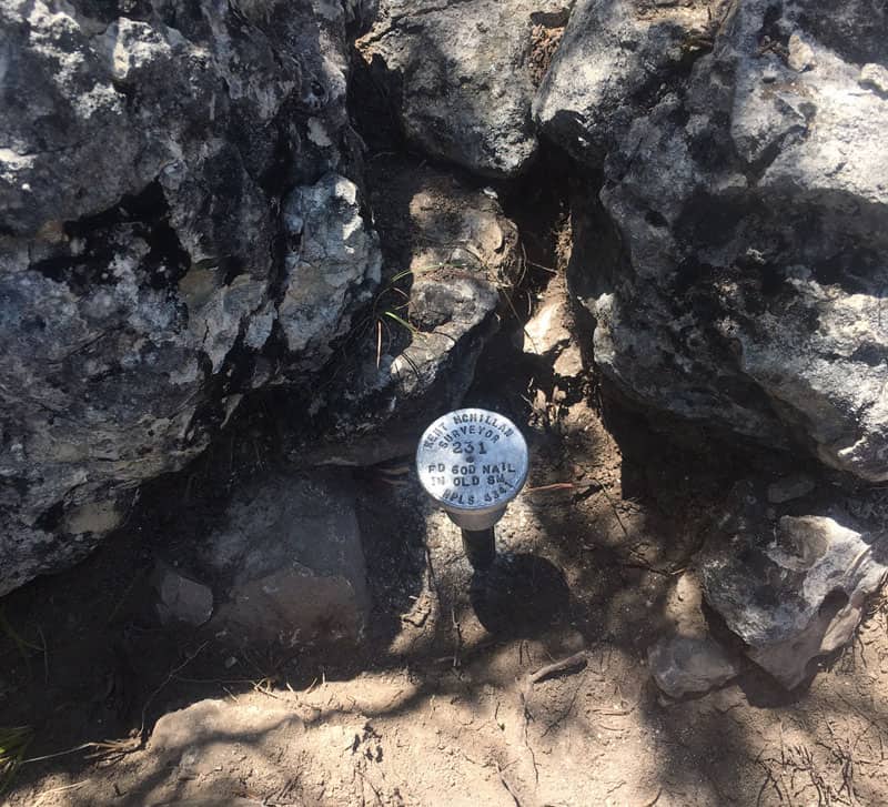
One of yesterday's tasks was to search for a land grant corner that Travis County Deputy Surveyor Dennis Corwin had made in 1871 out in the Hill Country West of Austin. It was a corner to which a survey made in 1879 was tied that was itself reportedly tied to yet another survey that is the true object of my investigation. (This is the typical metes and bounds problem of working backwards in the sequence of surveys, each of which depends upon some prior survey for evidence of its location.)
Mr. Corwin had stated in his field notes that he'd marked the corner with a
"Stone Mound from which a Spanish Oak 6 inches in diameter bears N7?øW, 4 varas and a Cedar bears N71?øE, 4 varas"
The search coordinates I'd calculated fell on a hillside with lots of cedars, but few large enough to have been suitable for a bearing tree in 1871. The call for a "Spanish Oak" meant a Texas Red Oak, Quercus texana, which narrowed the search since the Texas Red Oaks are fairly particular about where they grow, favoring somewhat deeper soils on slopes, particularly at the downhill sides of limestone ledges.
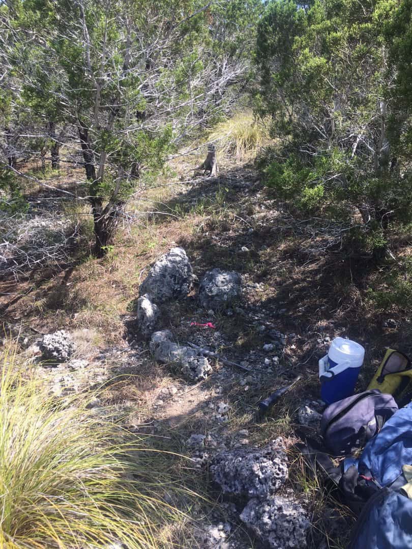
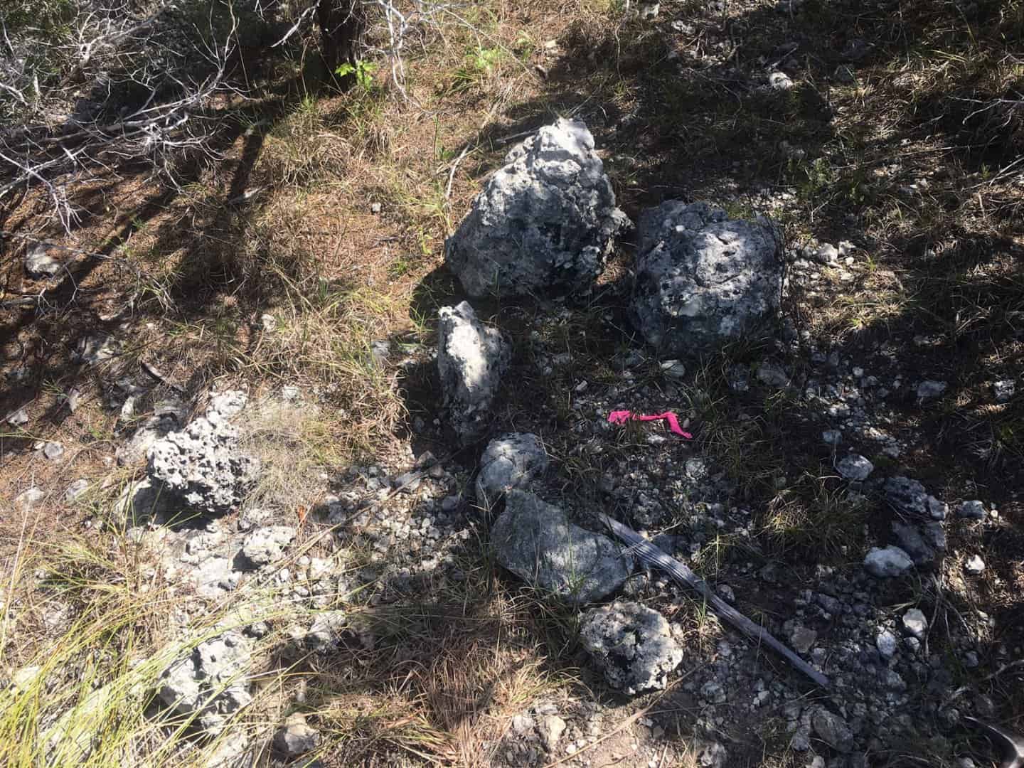
The first look was at a fence corner, but there was no trace of either the rock mound or the bearing trees, so I searched a wider radius and at about 30 ft. from the fence corner found a cluster of large and medium size stones that looked like the possible remains of a rock mound.
On closer inspection, I saw that some surveyor had set a 60d Nail among the stones some time sufficiently long ago for the flagging to have weathered to dust. So, what I thought looked like a rock mound had looked like a rock mound to some other prior surveyor as well.
Back in the office, I traced the chain of title of the adjacent tract back to discover that the surveyor who'd left the 60d nail in the rock mound was in fact a friend of mine, the late M.O. "Orin" Metcalfe, Jr. who in 1971 had found the mound and set the nail to give the irregular mound an exact center, describing the mound as the same corner of the survey that I was searching for, giving a tie to it from a pipe that he set by the fence corner about 30 ft. away.
On the way out to the field today, I stopped by the office of another friend who now has the Metcalfe records to see what else Orin had found. His field book did not indicate that he'd found either of the bearing trees, but was convinced by the fact that the mound lay approximately on the prolongation of a wire fence that angled off the original land grant line for reasons that probably made sense at the time to the folks who built the fence.
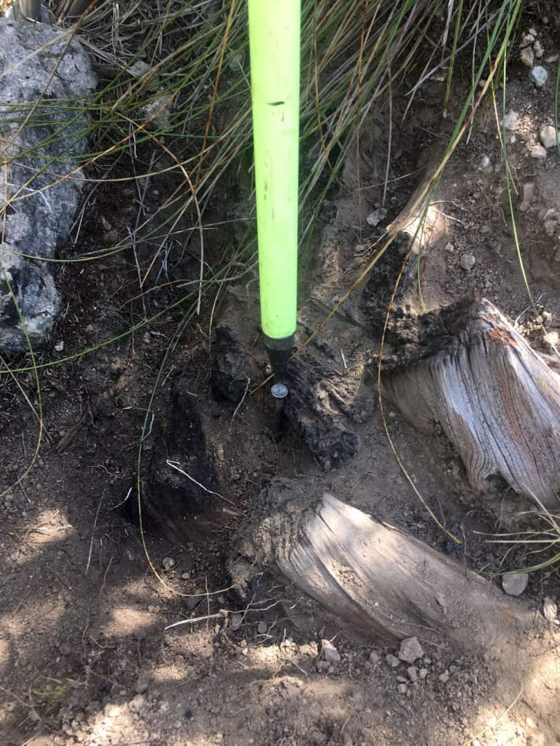
This morning, it was back to the corner to search a bit more for any evidence of the bearing trees that a casual inspection had indicated were not in place. As it turns out, the cedar (Ashe juniper) was down, but not entirely gone. A bit of work with a whisk broom exposed the charred stump of a cedar of sufficient size to have made a bearing tree. From examining the sizes of the cedars standing now interspersed with charred stumps, I'd say that the burn that turned the upper surface of the stump to charcoal probably occurred before 1930.
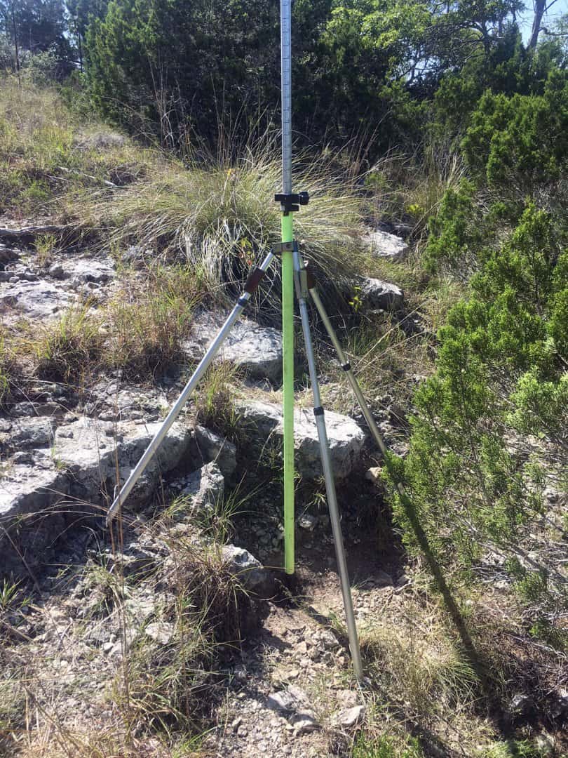
The Texas Red Oak/Spanish Oak was no longer there, but the position fell near a stumphole evidenced by a change in soil texture on the downhill side of a limestone ledge.
So, I set spikes in the cedar stump and where I thought the stumphole was and located them and the old 60d Nail that Orin had set in 1971.
From the 60d Nail:
Spike at Center of Cedar Stump:
N78?ø47'E, 4.000 vrs. (Corwin, 1871: N71?øE, 4 vrs.)
Spike at Estimated Center of Stump Hole:
N1?ø59'E, 4.325 vrs. (Corwin, 1871: N7?øW, 4 vrs.)
Both of the above bearings refer to Grid North of the Texas Coordinate System of 1983 (Central Zone)
Considering that Dennis Corwin failed to note the variation that he'd adjusted his compass to, but that a variation of 10?ø30'E was in universal use in Travis County at the time and had been since at least the 1840s,, that would mean that "North" as used by him in 1871 probably had an average direction of N2?ø22'W (Texas Coordinate System of 1983, Central Zone), It looks as if I'll probably end up setting a rod and cap in a slightly different position than the 60d Nail, but will leave the 60d Nail in place since it is referenced in the description of record that I mentioned.
Without the nail in the mound, I probably would have marked the center of the mound about a foot away from the nail, and that position based upon the study of the stones actually fits the BT evidence better than the old nail. I really don't think that Orin will mind since his field book doesn't indicate that he found the cedar stump.
If the record was reported to the nearest vara, and your "true" point is only a foot away from the nail, why are you pin cushioning the corner?
aliquot, post: 442194, member: 2486 wrote: If the record was reported to the nearest vara, and your "true" point is only a foot away from the nail, why are you pin cushioning the corner?
He isn't. The corner is the rock mound and it's 6' in diameter.
If that stump was burned before the 30's, it's roots are in remarkably good shape - they don't really look rotten at all. Is that a result of the type of tree or soil/climate conditions? Also, what kind of rocks are those - they kind of look like concrete scraps (I know they're not).
Allen Wrench, post: 442206, member: 6172 wrote: If that stump was burned before the 30's, it's roots are in remarkably good shape - they don't really look rotten at all. Is that a result of the type of tree or soil/climate conditions? Also, what kind of rocks are those - they kind of look like concrete scraps (I know they're not).
The rocks are Edwards Limestone, a formation in which that swiss-cheese structure is common. The Ashe Juniper aka Mountain Cedar (Juniperus ashei) is very rot-resistant, particularly in a well drained, gravelly soil such as where that stump is. My estimate is that the stump has been there for nearly a century in its present state. It is in such good shape that it's probably good for another century or more.
aliquot, post: 442194, member: 2486 wrote: If the record was reported to the nearest vara, and your "true" point is only a foot away from the nail, why are you pin cushioning the corner?
The nail was evidently set based solely upon an evaluation of the scatter of the mound that my examination of the stones indicates is really two distinct parts, i.e. an intact part of the mound and some stones that have been scattered from the mound. This is supported by the bearing tree evidence, the main element of which is the cedar stump. The apparent stump hole at the base of the limestone is something that simply confirms that a Spanish Oak could have grown in that position. Had the position fallen somewhere that it was implausible for the missing tree to have grown, that would have been contrary evidence.
Since the point is to determine where the 1871 corner of that senior survey really is on the ground, the fact that my friend Orin set a 60d nail that was good enough for his purposes at the time, but which I don't think took into proper account all of the original evidence that existed means that the nail can be shown not to correctly mark the 1871 corner. While Dennis Corwin, the 1871 surveyor, reported the short 4 vara distances to the BTs to the nearest vara, that means that the distances have a 68% chance of being correct within a foot.
His bearings to the trees are to the nearest degree, which makes them an even more certain condition than the distance measurement. Texas courts have generally considered bearings to be a superior, more reliable element than distances, although over only 4 varas I would tend to think that the actual limits of each are precision of expression and the fact that the tree may not have grown perfectly plumb from the position of the stump.
Basically, I take the tie that Orin recited in 1971 to have been mainly intended just to demonstrate that the fence corner was about 30 ft. distant from where the land grant corner was. In his analysis, a pipe he set by a fence corner was the corner of the 1871 land grant "as fenced and used upon the ground", but noted for the record that what he thought to be the original corner of that land grant was 31.17 ft. distant. I'll leave the nail in place, but his pipe is still in place marking the corner of the tract "as fenced and used upon the ground", as are a whole series of other markers he left. The nail is more of a loose end than a critical element of the description he left, meaning : the location of the boundary he described hardly depends upon the nail being exactly at the corner of the 1871 land grant.
Kent McMillan, post: 442226, member: 3 wrote: The nail was evidently set based solely upon an evaluation of the scatter of the mound that my examination of the stones indicates is really two distinct parts, i.e. an intact part of the mound and some stones that have been scattered from the mound. This is supported by the bearing tree evidence, the main element of which is the cedar stump. The apparent stump hole at the base of the limestone is something that simply confirms that a Spanish Oak could have grown in that position. Had the position fallen somewhere that it was implausible for the missing tree to have grown, that would have been contrary evidence.
Since the point is to determine where the 1871 corner of that senior survey really is on the ground, the fact that my friend Orin set a 60d nail that was good enough for his purposes at the time, but which I don't think took into proper account all of the original evidence that existed means that the nail can be shown not to correctly mark the 1871 corner. While Dennis Corwin, the 1871 surveyor, reported the short 4 vara distances to the BTs to the nearest vara, that means that the distances have a 68% chance of being correct within a foot.
His bearings to the trees are to the nearest degree, which makes them an even more certain condition than the distance measurement. Texas courts have generally considered bearings to be a superior, more reliable element than distances, although over only 4 varas I would tend to think that the actual limits of each are precision of expression and the fact that the tree may not have grown perfectly plumb from the position of the stump.
Basically, I take the tie that Orin recited in 1971 to have been mainly intended just to demonstrate that the fence corner was about 30 ft. distant from where the land grant corner was. In his analysis, a pipe he set by a fence corner was the corner of the 1871 land grant "as fenced and used upon the ground", but noted for the record that what he thought to be the original corner of that land grant was 31.17 ft. distant. I'll leave the nail in place, but his pipe is still in place marking the corner of the tract "as fenced and used upon the ground", as are a whole series of other markers he left. The nail is more of a loose end than a critical element of the description he left.
I didn't realise the nail was not ment to be the corner. I just came across three rebar for a SHC corner. The latter two were both less than one link from the earliest. The different positions resulted from different proportioning methods. I think it is ridiculous to reject a corner set in a reasonable manner that is less then the record reported precision from your position. I thought this was a situation like that.
aliquot, post: 442229, member: 2486 wrote: I didn't realise the nail was not ment to be the corner. I just came across three rebar for a SHC corner. The latter two were both less than one link from the earliest. The different positions resulted from different proportioning methods. I think it is ridiculous to reject a corner set in a reasonable manner that is less then the record reported precision from your position. I thought this was a situation like that.
I'm pretty sure that my late friend thought the nail was very near the corner, but I'm also pretty sure that if the purpose of his survey had been to definitely locate the corner of the 1871 land grant, he'd have uncovered the cedar stump and replaced the corner with a stout monument based upon it.
But wait, there's more to the story because today vindicated good old Orin Metcalfe who reported that he had surveyed a tie in 1971 to a 60d Nail that he'd set in an old Stone Mound he found and thought (correctly, I believe) to be the North corner of a certain land grant surveyed in 1871 in the Hill Country West of Austin. I found a 60d Nail in what I identified as the remnants of the original mound and thought that it was his.
That nail was simply too far out of agreement with the original evidence. It wasn't at the center of the remains of the mound and didn't fit the stump of a bearing tree plausibly well. So I went back today to set a rod and cap in the position of the original corner based upon the evidence I had. That involved cleaning up the mound a bit more to verify that what appeared to be a more or less intact half of the mound was in fact just that. So, in the process of using a screwdriver and a whisk broom to sweep away the soil that had filled in the mound a bit, lo and behold, what came to light but Orin's actual 60d Nail from 1971.
It was 0.92 ft. distant from the 60d Nail I'd thought at first impression was his and was within about 0.15 ft. of where I would have marked the center of the remains of the old stone mound were there no mark there. The tie from the nail to his 3/4 in. pipe that is now on the other side of an 8 ft. high fence checked essentially perfectly, so case closed as to identity.
I went ahead and replaced the nail with a punchmark on an aluminum cap affixed to a 5/8 in. rebar driven into a drill hole in rock, leaving it up a bit so that it will take quite a while for enough soil to wash in to cover it. The stamping tells the story; "231, FD 60D NAIL IN OLD SM".
Closeup showing the organized, intact part of the stone mound:
The time scale on that one is worth noting.
1871 - Travis County Deputy Surveyor Dennis Corwin locates 160-acre Preemption (Homestead) grant, building stone mound to mark North corner of tract eventually patented to actual settler.
1879 - Travis County Surveyor John E. Campbell finds Corwin's North corner of 160 acres reporting "old bearings standing still"
1914 - Travis County Survey H.G. Lee claims to find North corner of 160-acre grant.
1971 - Orin Metcalfe, RPS (later RPLS) finds remains of Corwin's original stone mound and sets 60d Nail to mark center
2017 - Kent McMillan, RPLS finds Corwin's original stone mound and eventually manages to find Metcalfe's nail after being distracted by arduous work of posting to surveyors' message board. McMillan replaces Metcalfe's nail with more permanent and durable marker but remains puzzled by H.G. Lee's claims in 1914. McMillan reaches preliminary conclusion that Lee probably did not actually survey all of the lines he claimed to have done.
This is so complex I can barely get my head around it. You found a scattered stone pile, then got yourself to the stump, then backed the rotated bearing and distance to the corner where a 60d nail was found in the pile and replaced with a pin. My only question is why didn't you find both nails the first time. If they were just 60d nails and a foot apart, a careful user should have been able to find both with a metal detector.
Roger,
I believe the simple answer to your question is contained in the opening phrase of Post #10, "But wait there's more to the story....". Kent is merely exercising his literary license to build up the intrigue and mystery of his survey noir.
[SARCASM]Either that or the contract allows for multiple site visits.[/SARCASM]
roger_LS, post: 442311, member: 11550 wrote: This is so complex I can barely get my head around it. You found a scattered stone pile, then got yourself to the stump, then backed the rotated bearing and distance to the corner where a 60d nail was found in the pile and replaced with a pin. My only question is why didn't you find both nails the first time. If they were just 60d nails and a foot apart, a careful user should have been able to find both with a metal detector.
The short answer is that the location is at the end of a half-mile carry in 103?øF temps and one where the prospect of two 60d nails in a roughly 2.4 ft. dia. rock mound seemed like a low probability event. So the metal detector got left behind in favor of the Suunto hand compass which also would have picked up the second nail, but it didn't occur to me that there could possibly be a second nail in that location, so the Suunto stayed in my vest pocket.
That may have been the heat which, of course, would not be present in most of PLSSia where I believe the solution would have been to just locate the first 60d nail in view and call it the "established" corner and file a corner record to validate that judgment.
I'm still wondering how he crossed the 8 foot game fence. I was hoping it involved some sort of catapult contraption.
Kent McMillan, post: 442226, member: 3 wrote: but noted for the record that what he thought to be the original corner of that land grant was 31.17 ft. distant.
Kent McMillan, post: 442292, member: 3 wrote: The tie from the nail to his 3/4 in. pipe that is now on the other side of an 8 ft. high fence checked essentially perfectly, so case closed as to identity.
Cool story. What led you to initially believe Orin had blown his tie distance to the pipe at the fence corner by a foot? Or did you not have that tie distance until before you made the last visit to the SM?
Cameron Watson PLS, post: 442326, member: 11407 wrote: Cool story. What led you to initially believe Orin had blown his tie distance to the pipe at the fence corner by a foot? Or did you not have that tie distance until before you made the last visit to the SM?
I didn't think that I'd need the tie to the pipe that Orin set that is now on the other side of an 8-ft. fence and, in any event, I was more concerned with identifying the 1871 survey corner from original evidence that woud have the most probative weight.
In that scenario, I considered my friend Orin's work to be more potentially confirmatory than determinative and only began to examine what he had really done when the first 60d nail was found to be in a position that just looked wrong in Texas (although not evidently in parts of PLSSia where a foot is nothing).
Andy Nold, post: 442321, member: 7 wrote: I'm still wondering how he crossed the 8 foot game fence. I was hoping it involved some sort of catapult contraption.
Oh, sorry not to post photos. In the event, it was very easy to climb over. Probably would have been a bit trickier with lots of equipment to transfer, but I was travelling light and didn't have all that, uh, "stuff".
Kent McMillan, post: 442328, member: 3 wrote: parts of PLSSia where a foot is nothing
You so funny!!!! Snooty but funny as hell. No more "Cool story" comments for you though :joy::joy::joy:
Cameron Watson PLS, post: 442333, member: 11407 wrote: You so funny!!!! Snooty but funny as hell.
I know, it sounds odd, but a poster from PLSSia using the pseudonym (I assume) of aliquot said that anything within a foot was plenty close for him and wondered why it could possibly be a problem anywhere else. This is how one learns about what actually goes on in PLSSia beyond Gene Kooper's tips for faking stone corners by cultivating lichens on them.
