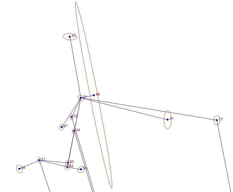
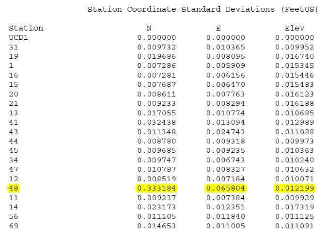
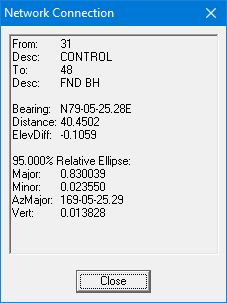
I'm scratching my head over this one, so I'm hoping someone can explain it for me. I did a survey that includes some radial ties, and the same equipment and observation procedures were used on all of them. However, for one of them Star*Net is showing a huge error ellipse:
Point 48 is only about 40 feet from point 31. The standard error associated with point 48 doesn't make any sense to me.
Can someone clue me in to what's going on with point 48?
Thanks!
It appears to be derived from the angular error estimate. What do you have for angular weighting?
41 and 43 look okay, maybe you have a bad angle in the set to 48?
My StarNet problem this week turned out to be a zero target height on one observation in a set of 8, that really upset StarNet. I had to buy it flowers and a candlelight dinner.
Since you say radial ties, I assume it is a sideshot? So no matter if your data is correct or not it would not affect anything. I would have to guess that the angular error is set high, so on a short sight it produces a larger uncertainty.
It's funny how these problems usually have a simple fix but darned if I can see it. Stare at the data for an hour and the one number out of place isn't visible to me then I finally see it and say duh it's right there staring at me.
Can you post the DAT file? My first guess would be that you have some stray numbers in the measurement line for that point. Or maybe a second line with the same point but slightly different numbers causing the high std devs.
I see a facepalm/forehead slap in your near future....
Jim Frame, post: 432632, member: 10 wrote: I'm scratching my head over this one, so I'm hoping someone can explain it for me. I did a survey that includes some radial ties, and the same equipment and observation procedures were used on all of them. However, for one of them Star*Net is showing a huge error ellipse:
Point 48 is only about 40 feet from point 31. The standard error associated with point 48 doesn't make any sense to me.
Can someone clue me in to what's going on with point 48?
Thanks!
Jim,
It seems like it put a little more of the network error into no. 13 and then that make the side shot on nos. 41, 43 and 48 greater uncentanty based on the distance. So I agree with what John said. The other shots have a tighter control.
Jim Frame, post: 432632, member: 10 wrote: I'm scratching my head over this one, so I'm hoping someone can explain it for me. ...Can someone clue me in to what's going on with point 48?
I'll second the request to see the .DAT file. My (somewhat educated) guess would be that the cause of the anomoly lies there.
I'd also like to see the .dat. I'll go a little further and suggest that you tied 48 at least twice, and you probably have a bad split between the two observations. Check the horizontal angle residuals.
Here's the DAT file prior to today's work:
[PRE]
.UNITS METERS
#
# CRTN position:
#
PH UCD1 38.3210449957 121.4504380424 0.0915 ! ! !
PH 31 38.3252 121.4519 -30
#
.UNITS FEETUS
#
# C records for description purposes:
#
C 31 1961398.224800000 6631616.204740000 44.10324 'CONTROL
C 19 1960832.133440000 6633233.998880000 46.56587 'CONTROL
C 1 1960809.994100000 6631964.836810000 45.29451 'CONTROL
C 16 1960783.783210000 6632057.522980000 45.57611 'FND SMAW UCD 763
C 15 1960897.324810000 6631929.989460000 45.44387 'FND 5/5" RB LS 6829
C 20 1960896.359250000 6632054.987920000 45.50501 'FND PK & TAG LS 6829
C 21 1960895.338120000 6632179.980670000 45.15383 'FND PK NO TAG
C 13 1961330.111530000 6632030.791710000 44.38358 'CONTROL
C 41 1961331.683930000 6631880.847740000 43.86553 'FND BH
C 43 1961584.646320000 6631583.227580000 43.30097 'FND BH
C 44 1961187.008320000 6631575.629360000 46.76191 'CONTROL
C 45 1961199.839770000 6631577.349820000 46.96711 'CONTROL
C 34 1961296.768050000 6631596.256180000 44.46142 'FND N&T LS2???
C 47 1961308.731280000 6631558.111520000 44.42040 'FND NAIL
C 12 1961339.104790000 6631588.614320000 44.00261 'FND BH
C 48 1961405.887630000 6631655.922510000 43.99730 'FND BH
C 11 1961207.904090000 6631490.166500000 47.12527 'CONTROL
C 14 1960897.716260000 6631560.540780000 46.93974 'FND N&T LS1880
#
.INST GEOMAX
#
# From 8250-098 (02/15/2016):
#
# Point substitutions:
#
# 8250-098 4841-001
#
# 239 19
# 309 15
# 259 1
# 308 18
# 311 20
# 310 21
#
C 19 1960832.154 6633233.965 46.50 0.02 0.04 0.07 'CONTROL
#
M 19-1-19 ? 1269.405 89.5558 4.832/5.062 'CONTROL
M 19-1-16 16.4731 96.337 89.4400 4.832/5.000 'FND SMAW UCD 763
#
M 19-1-19 ? 1269.405 89.5600 4.832/5.062 'CONTROL
M 19-1-15 249.1424 94.043 89.4818 4.832/5.000 'FND 5/5" RB LS 6829
#
M 19-1-19 ? 1269.407 89.5556 4.832/5.062 'CONTROL
M 19-1-20 317.1341 124.850 89.4928 & & 60 4.832/5.000 'FND PK & TAG LS 6829
#
M 19-1-19 ? 1269.407 89.5557 4.832/5.062 'CONTROL
M 19-1-21 339.2143 231.462 89.5931 & & 60 4.832/5.000 'FND PK NO TAG
#
# Line 7: --Scale Point not used
# Line 8: --EDM Mode: Standard
# Line 12: --Scale Point not used
# Line 13: --EDM Mode: Standard
# Line 14: --06/13/17
# Line 15: --GEOMAX
# Line 27: --P.C. mm Applied: -16.9000 (Leica Mini:backsight)
#
M 13-31-13 ? 420.163 89.5754 5.022/5.000 'CONTROL
M 13-31-13 ? 420.162 89.5753 5.022/5.000 'CONTROL
#
M 13-31-13 ? 420.163 89.5754 5.022/5.000 'CONTROL
M 13-31-13 ? 420.160 89.5751 5.022/5.000 'CONTROL
# Line 81: --CHK 41
#
M 41-31-41 ? 272.891 90.0316 5.022/5.000 'FND BH MAYBE BAD
M 41-31-43 245.5117 189.325 90.1451 5.022/5.000 'FND BH
#
M 43-31-43 ? 189.325 90.1454 5.022/5.000 'FND BH
M 43-31-44 200.5421 215.102 89.1800 5.022/5.000 'CONTROL
#
M 44-31-44 ? 215.104 89.1800 5.022/5.000 'CONTROL
M 44-31-45 0.1226 202.182 89.1150 5.022/5.000 'CONTROL
#
M 45-31-45 ? 202.182 89.1148 5.022/5.000 'CONTROL
M 45-31-34 0.0232 103.401 89.4859 5.022/5.000 'CHK 34
#
M 34-31-34 ? 103.402 89.4858 5.022/5.000 'FND N+T
M 34-31-47 21.5156 106.700 89.5037 5.022/5.000 'FND NAIL
#
M 47-31-47 ? 106.700 89.5038 5.022/5.000 'FND NAIL
M 47-31-12 352.0145 65.247 90.0635 5.022/5.000 'FND BH
#
M 12-31-12 ? 65.246 90.0633 5.022/5.000 'FND BH
M 12-31-48 234.0344 40.452 90.1048 5.022/5.000 'FND BH
#
# Line 163: --DT06-14-2017
# Line 164: --TM09:47:09
# Line 168: --Scale Point not used
# Line 169: --EDM Mode: Standard
# Line 170: --06/14/17
# Line 171: --GEOMAX
# Line 172: --P.C. mm Applied: -16.9000 (Leica Mini:backsight)
#
M 14-1-14 ? 413.508 89.5248 5.530/5.000 'FND N & 1" TAG LS1880 CHK 6
M 14-1-21 146.0520 231.453 90.0818 5.530/5.000 'CHK 21
#
M 21-1-21 ? 231.454 90.0821 5.530/5.000 'FND PK NO TAG
M 21-1-20 337.5202 124.841 90.0744 5.530/5.000 'CHK 20
#
M 20-1-20 ? 124.841 90.0743 5.530/5.000 'FND PK & TAG LS 6829
M 20-1-15 292.0040 94.037 90.1325 5.530/5.000 'CHK 15
#
M 15-1-15 ? 94.036 90.1325 5.530/5.000 'FND RB & CAP LS6829 CHK 5
M 15-1-16 127.3240 96.328 90.0754 5.530/5.000 'CHK 16
#
M 31-44-31 ? 215.105 90.4548 5.202/5.000 'CONTROL
M 31-44-34 359.4605 111.719 91.1703 5.202/5.000 'CHK 34
#
M 34-44-34 ? 111.721 91.1703 5.202/5.000 'FND N&T LS2???
M 34-44-11 273.0345 87.964 89.5524 5.202/5.000 'CHK 11
M 34-44-45 356.5907 12.951 89.5944 5.202/5.000 'CHK 45
#
M 34-44-34 ? 111.719 91.1704 5.202/5.000 'FND N&T LS2???
M 34-44-56 89.2616 42.266 89.2101 5.202/5.250 'FND 3/4" IP
#
M 56-44-56 ? 42.266 89.2123 5.202/5.250 'FND 3/4" IP
M 56-44-31 270.4731 215.109 90.4545 5.202/5.000 'CHK 31
#
M 31-44-31 ? 215.111 90.4548 5.202/5.000 'CONTROL
M 31-44-11 272.4937 87.965 89.5525 5.202/5.000 'CHK 11
SS 31-44-59 90.0343 41.621 90.0120 5.202/5.000 '0.45S + 0.40E FNC N+E+W
SS 31-44-60 43.1036 43.311 89.3423 5.202/5.000 '0.25E FNC
SS 31-44-61 10.3800 73.119 90.1737 5.202/5.000 '0.7E FNC S + 6.1N
SS 31-44-62 169.3926 7.539 90.3909 5.202/5.000 'FNC E+W
SS 31-44-63 244.1428 29.244 90.0732 5.202/5.000 'FNC E+W
SS 31-44-64 249.4929 42.901 89.5938 5.202/5.030 'FNC E+W
SS 31-44-65 357.5058 54.882 90.0126 5.202/5.000 'BLD N + 8.66W
SS 31-44-66 346.1006 43.109 90.0007 5.202/5.000 'BLD N + 4.0W
SS 31-44-67 328.4048 26.284 89.4542 5.202/5.000 'BLD N*W
#
M 44-11-44 ? 87.965 90.1835 5.145/5.000 'CONTROL
M 44-11-45 351.3233 87.548 90.1043 5.145/5.000 'CHK 45
# Line 311: -- Inserted LS record:
M 44-11-69 142.3557 66.394 88.4455 5.145/6.450 'FND 1.5" IP
# Line 314: --|LAST 6.45 HR
#
M 69-11-69 ? 66.396 88.4516 5.145/6.450 'FND 1.5" IP
M 69-11-44 217.2347 87.969 90.1836 5.145/5.000 'CHK 44
#
SS 44-11-71 41.4013 33.388 90.1216 5.145/5.000 'FNC E+W
SS 44-11-72 128.5048 43.863 90.2357 5.145/5.000 'FNC E+W
SS 44-11-73 142.1611 64.749 89.5207 5.145/5.000 '0.55S FNC E+W 0.55NW FNC NE+SW
SS 44-11-74 156.4709 40.000 89.5443 5.145/5.000 'FNC NE+SW
SS 44-11-75 230.2440 23.806 90.3508 5.145/5.000 'FNC NE+SW
SS 44-11-76 282.1434 39.476 90.0919 5.145/5.000 '10.0 NW FNC NE+SW
SS 44-11-77 290.0618 41.502 89.5717 5.145/5.000 'BLD NE+SW
SS 44-11-78 313.1907 23.360 90.0657 5.145/5.000 'BLD N + E
#
# Notes Summary:
# Line 7: --Scale Point not used
# Line 8: --EDM Mode: Standard
# Line 12: --Scale Point not used
# Line 13: --EDM Mode: Standard
# Line 14: --06/13/17
# Line 15: --GEOMAX
# Line 27: --P.C. mm Applied: -16.9000 (Leica Mini:backsight)
# Line 81: --CHK 41
# Line 163: --DT06-14-2017
# Line 164: --TM09:47:09
# Line 168: --Scale Point not used
# Line 169: --EDM Mode: Standard
# Line 170: --06/14/17
# Line 171: --GEOMAX
# Line 172: --P.C. mm Applied: -16.9000 (Leica Mini:backsight)
# Line 311: -- Inserted LS record:
# Line 314: --|LAST 6.45 HR
[/PRE]
I retied the point again today, once from the same point and once from another one, and will see how that affects things.
P.S. I didn't include the .GPS file, but I didn't tie 48 with GPS so I don't think it matters for the issue at hand.
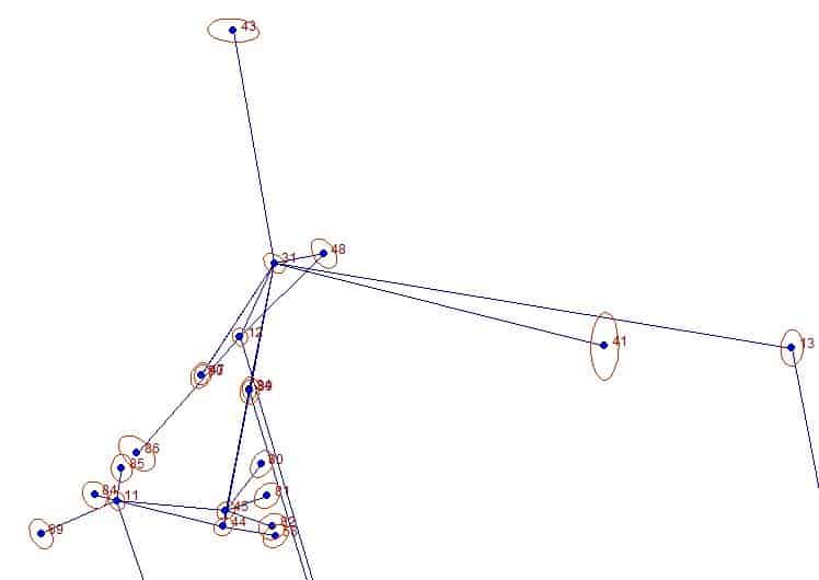
Here's what happens to the error ellipse when I add today's tie from 12 and a duplicate tie from 31:
Adding the tie from 12 throws a bit over 1 arc-minute into the angle at 31 to 48, not unreasonable for a 40-foot shot. But if I disable the tie from 12 and leave the duplicate tie from 31, the ellipse blows up again. I understand why the ellipse would be large at 48 hitting it from only 1 nearby location, but 0.3' at 1 sigma and 0.8' at 2 sigma still seems unreasonably large to me.
The angle and centring standard errors would be interesting to see.
I wonder what the result would be with the observations at 31 in a directions set.
Is the above plot from an adjustment without GPS input?
If not, does it give the same result without the GPS? ie just fix one coord and a bearing?
centering errors should show up as a constant size affect on the error ellipses UNLESS one takes a backsight on a nearby point, in which case the error will be amplified on a longer foresight. But errors due to angular uncertainty would be largest on the shortest shot.
I used 0.005 foot for centering of both instrument and target.
squowse, post: 432711, member: 7109 wrote: Is the above plot from an adjustment without GPS input?
Running the adjustment without the GPS input would require a lot of editing that I'm not inclined to do at the moment, but since all the GPS ties are RTK (though with multiple redundant ties), they're subordinate to the total station ties in terms of weight. I don't think removing the GPS would affect the matter at point 48.
My guess is that the problem was created by this line:
#
M 12-31-12 ? 65.246 90.0633 5.022/5.000 'FND BH
M 12-31-48 234.0344 40.452 90.1048 5.022/5.000 'FND BH
#
Why isn't that a DV line instead of an M line? Change it to that and tell us if the problem disappears.
Kent McMillan, post: 432774, member: 3 wrote: Why isn't that a DV line instead of an M line? Change it to that and tell us if the problem disappears.
Those From-At-From M lines result from conversion of the raw data, and they're present for all of the sets in the project. They represent the readings from the instrument station to the backsight. Changing that one to a DV line didn't improve the ellipse at 48.
Kent McMillan, post: 432774, member: 3 wrote: Why isn't that a DV line instead of an M line? Change it to that and tell us if the problem disappears.
I went through Jim's data And edited all those ? lines to DV's, which is what I'm familiar with. But It doesn't seem to make any difference.
Using a few seed coordinates from Jim's list as required the data adjusts very well. I'm getting a funky orientation (I do realize that this is "FromAtTo" order) of the whole thing but the data is passing easily, so that's probably a function of the FromAtTo that I'm not getting right. So now I'm thinking I'd be looking at the residuals in the RTK.
[PRE]
.UNITS FEETUS
.3d
C 31 1961398.22480 6631616.20474 44.10324 0.1 0.1 0.1 'CONTROL
C 13 1961330.11153 6632030.79171 44.38358 0.1 0.1 0.1 'CONTROL
C 41 1961331.68393 6631880.84774 43.86553 0.1 0.1 0.1 'FND BH
.ORDER fromATto
.3d
.data OFF
DV 19-1 1269.405 89.5558 4.832/5.062 'CONTROL
M 19-1-16 16.4731 96.337 89.4400 4.832/5.000 'FND SMAW UCD 763
DV 19-1 1269.405 89.5600 4.832/5.062 'CONTROL
M 19-1-15 249.1424 94.043 89.4818 4.832/5.000 'FND 5/5" RB LS 6829
DV 19-1 1269.407 89.5556 4.832/5.062 'CONTROL
M 19-1-20 317.1341 124.850 89.4928 & & 60 4.832/5.000 'FND PK & TAG LS 6829
DV 19-1 1269.407 89.5557 4.832/5.062 'CONTROL
M 19-1-21 339.2143 231.462 89.5931 & & 60 4.832/5.000 'FND PK NO TAG
.data ON
DV 31-13 420.163 89.5754 5.022/5.000 'CONTROL
DV 31-13 420.162 89.5753 5.022/5.000 'CONTROL
DV 31-13 420.163 89.5754 5.022/5.000 'CONTROL
DV 31-13 420.160 89.5751 5.022/5.000 'CONTROL
DV 31-41 272.891 90.0316 5.022/5.000 'FND BH MAYBE BAD
M 41-31-43 45.5117 189.325 90.1451 5.022/5.000 'FND BH
DV 31-43 189.325 90.1454 5.022/5.000 'FND BH
M 43-31-44 200.5421 215.102 89.1800 5.022/5.000 'CONTROL
DV 31-44 215.104 89.1800 5.022/5.000 'CONTROL
M 44-31-45 0.1226 202.182 89.1150 5.022/5.000 'CONTROL
DV 31-45 202.182 89.1148 5.022/5.000 'CONTROL
M 45-31-34 0.0232 103.401 89.4859 5.022/5.000 'CHK 34
DV 31-34 103.402 89.4858 5.022/5.000 'FND N+T
M 34-31-47 21.5156 106.700 89.5037 5.022/5.000 'FND NAIL
DV 31-47 106.700 89.5038 5.022/5.000 'FND NAIL
M 47-31-12 352.0145 65.247 90.0635 5.022/5.000 'FND BH
DV 31-12 65.246 90.0633 5.022/5.000 'FND BH
M 12-31-48 234.0344 40.452 90.1048 5.022/5.000 'FND BH
#DV 14-1 413.508 89.5248 5.530/5.000 'FND N & 1" TAG LS1880 CHK 6
#M 14-1-21 146.0520 231.453 90.0818 5.530/5.000 'CHK 21
#DV 21-1 231.454 90.0821 5.530/5.000 'FND PK NO TAG
#M 21-1-20 337.5202 124.841 90.0744 5.530/5.000 'CHK 20
#DV 20-1 124.841 90.0743 5.530/5.000 'FND PK & TAG LS 6829
#M 20-1-15 292.0040 94.037 90.1325 5.530/5.000 'CHK 15
#DV 15-1 94.036 90.1325 5.530/5.000 'FND RB & CAP LS6829 CHK 5
#M 15-1-16 127.3240 96.328 90.0754 5.530/5.000 'CHK 16
DV 44-31 215.105 90.4548 5.202/5.000 'CONTROL
M 31-44-34 359.4605 111.719 91.1703 5.202/5.000 'CHK 34
DV 44-34 111.721 91.1703 5.202/5.000 'FND N&T LS2???
M 34-44-11 273.0345 87.964 89.5524 5.202/5.000 'CHK 11
M 34-44-45 356.5907 12.951 89.5944 5.202/5.000 'CHK 45
DV 44-34 111.719 91.1704 5.202/5.000 'FND N&T LS2???
M 34-44-56 89.2616 42.266 89.2101 5.202/5.250 'FND 3/4" IP
DV 44-56 42.266 89.2123 5.202/5.250 'FND 3/4" IP
M 56-44-31 270.4731 215.109 90.4545 5.202/5.000 'CHK 31
DV 44-31 215.111 90.4548 5.202/5.000 'CONTROL
M 31-44-11 272.4937 87.965 89.5525 5.202/5.000 'CHK 11
SS 31-44-59 90.0343 41.621 90.0120 5.202/5.000 '0.45S + 0.40E FNC N+E+W
SS 31-44-60 43.1036 43.311 89.3423 5.202/5.000 '0.25E FNC
SS 31-44-61 10.3800 73.119 90.1737 5.202/5.000 '0.7E FNC S + 6.1N
SS 31-44-62 169.3926 7.539 90.3909 5.202/5.000 'FNC E+W
SS 31-44-63 244.1428 29.244 90.0732 5.202/5.000 'FNC E+W
SS 31-44-64 249.4929 42.901 89.5938 5.202/5.030 'FNC E+W
SS 31-44-65 357.5058 54.882 90.0126 5.202/5.000 'BLD N + 8.66W
SS 31-44-66 346.1006 43.109 90.0007 5.202/5.000 'BLD N + 4.0W
SS 31-44-67 328.4048 26.284 89.4542 5.202/5.000 'BLD N*W
DV 11-44 87.965 90.1835 5.145/5.000 'CONTROL
M 44-11-45 351.3233 87.548 90.1043 5.145/5.000 'CHK 45
M 44-11-69 142.3557 66.394 88.4455 5.145/6.450 'FND 1.5" IP
DV 11-69 66.396 88.4516 5.145/6.450 'FND 1.5" IP
M 69-11-44 217.2347 87.969 90.1836 5.145/5.000 'CHK 44
SS 44-11-71 41.4013 33.388 90.1216 5.145/5.000 'FNC E+W
SS 44-11-72 128.5048 43.863 90.2357 5.145/5.000 'FNC E+W
SS 44-11-73 142.1611 64.749 89.5207 5.145/5.000 '0.55S FNC E+W 0.55NW FNC NE+SW
SS 44-11-74 156.4709 40.000 89.5443 5.145/5.000 'FNC NE+SW
SS 44-11-75 230.2440 23.806 90.3508 5.145/5.000 'FNC NE+SW
SS 44-11-76 282.1434 39.476 90.0919 5.145/5.000 '10.0 NW FNC NE+SW
SS 44-11-77 290.0618 41.502 89.5717 5.145/5.000 'BLD NE+SW
SS 44-11-78 313.1907 23.360 90.0657 5.145/5.000 'BLD N + E
[/PRE]
Jim Frame, post: 432787, member: 10 wrote: Those From-At-From M lines result from conversion of the raw data, and they're present for all of the sets in the project. They represent the readings from the instrument station to the backsight. Changing that one to a DV line didn't improve the ellipse at 48.
Well, my strong suspicion is that there is something about the processing of the data that left Pt. 12 as a station with a large uncertainty that was simply propagated into the tie measured with 12 as a BS. The substitution of M lines for what should logically be DV lines is wierdly suspicious.
Mark Mayer, post: 432789, member: 424 wrote: I went through Jim's data And edited all those ? lines to DV's, which is what I'm familiar with. But It doesn't seem to make any difference.
Using a few seed coordinates from Jim's list as required the data adjusts very well. I'm getting a funky orientation (I do realize that this is "FromAtTo" order) of the whole thing but the data is passing easily, so that's probably a function of the FromAtTo that I'm not getting right. So now I'm thinking I'd be looking at the residuals in the RTK.
Except, a large residual in the RTK derived positions should blow up the adjustment statistics and I'm assuming that Jim didn't see that in the statistical summary.


