Reading RPLS is free for the whole profession. Members post, reply, and get the members-only rooms.

Notifications
Clear all

Topic starter
Translate
▼
English
Spanish
French
German
Italian
Portuguese
Russian
Chinese
Japanese
Korean
Arabic
Hindi
Dutch
Polish
Turkish
Vietnamese
Thai
Swedish
Danish
Finnish
Norwegian
Czech
Hungarian
Romanian
Greek
Hebrew
Indonesian
Malay
Ukrainian
Bulgarian
Croatian
Slovak
Slovenian
Serbian
Lithuanian
Latvian
Estonian
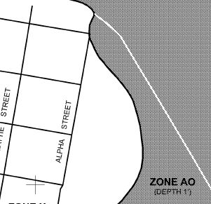
I have a client who tells me that the county is requesting an Elevation Certificate for a parcel that's in Zone AO with a 1' depth shown on the FIRM. I've not dealt with Zone AO before. The site is pretty flat; would it be appropriate to add 1 foot to the highest site grade and call that BFE?
Posted : June 15, 2017 8:09 am

Translate
▼
English
Spanish
French
German
Italian
Portuguese
Russian
Chinese
Japanese
Korean
Arabic
Hindi
Dutch
Polish
Turkish
Vietnamese
Thai
Swedish
Danish
Finnish
Norwegian
Czech
Hungarian
Romanian
Greek
Hebrew
Indonesian
Malay
Ukrainian
Bulgarian
Croatian
Slovak
Slovenian
Serbian
Lithuanian
Latvian
Estonian
I am not overly familiar with AO, however on the Fema Flood Certificate Form, where it asks for BFE in ( ) its states in Zone AO use base flood depth. In your case with the diagram you provided, 1' would be entered in that section of the form. Not to sure how to correlate this with elevations you will potentially obtain in the field, I would be interested if anyone else would know how to determine.
Posted : June 15, 2017 9:15 am

Translate
▼
English
Spanish
French
German
Italian
Portuguese
Russian
Chinese
Japanese
Korean
Arabic
Hindi
Dutch
Polish
Turkish
Vietnamese
Thai
Swedish
Danish
Finnish
Norwegian
Czech
Hungarian
Romanian
Greek
Hebrew
Indonesian
Malay
Ukrainian
Bulgarian
Croatian
Slovak
Slovenian
Serbian
Lithuanian
Latvian
Estonian
Just place the flood depth in the BFE, let the adjusters sort it out. For the purposes of complying with FEMA requirements/local floodplain ordinances the HAG plus the flood depth is the BFE for determining if the lowest floor is in compliance.
Posted : June 15, 2017 12:18 pm

Translate
▼
English
Spanish
French
German
Italian
Portuguese
Russian
Chinese
Japanese
Korean
Arabic
Hindi
Dutch
Polish
Turkish
Vietnamese
Thai
Swedish
Danish
Finnish
Norwegian
Czech
Hungarian
Romanian
Greek
Hebrew
Indonesian
Malay
Ukrainian
Bulgarian
Croatian
Slovak
Slovenian
Serbian
Lithuanian
Latvian
Estonian
Just place the flood depth in the BFE, let the adjusters sort it out. For the purposes of complying with FEMA requirements/local floodplain ordinances the HAG plus the flood depth is the BFE for determining if the lowest floor is in compliance.
Thank you for this I just got a similar request to Jim and not sure how to estimate it.
Incidentally, the EC form expired in November 2022, has anyone heard if we should continue using it??ÿ I'm not seeing any updates around and historically they have not changed much....
?ÿ
Posted : January 20, 2023 2:16 pm

Translate
▼
English
Spanish
French
German
Italian
Portuguese
Russian
Chinese
Japanese
Korean
Arabic
Hindi
Dutch
Polish
Turkish
Vietnamese
Thai
Swedish
Danish
Finnish
Norwegian
Czech
Hungarian
Romanian
Greek
Hebrew
Indonesian
Malay
Ukrainian
Bulgarian
Croatian
Slovak
Slovenian
Serbian
Lithuanian
Latvian
Estonian
Ran into that issue a couple of weeks back.?ÿ Called FEMA HQ and told them to send me the current version.?ÿ What they sent expired in 2014, so I took that to be the current version for a LOMA.
Posted : January 20, 2023 2:20 pm

Translate
▼
English
Spanish
French
German
Italian
Portuguese
Russian
Chinese
Japanese
Korean
Arabic
Hindi
Dutch
Polish
Turkish
Vietnamese
Thai
Swedish
Danish
Finnish
Norwegian
Czech
Hungarian
Romanian
Greek
Hebrew
Indonesian
Malay
Ukrainian
Bulgarian
Croatian
Slovak
Slovenian
Serbian
Lithuanian
Latvian
Estonian
I guess it??s better than Zone A. The school district in Parkfield provides a house for the teacher and family (remote town). The only place on the school property not in Zone A is the lowest corner, crazy, so that??s where they built the house.
Zone AO is the magic zone where the water slopes with the ground. Had one where Lot 51 could build their house lower than the adjoining lot??s ground which had to build way up in the air.
I know the flood maps are not flood maps, they are a risk assessment tool.
Posted : January 20, 2023 9:00 pm
Topic starter
Translate
▼
English
Spanish
French
German
Italian
Portuguese
Russian
Chinese
Japanese
Korean
Arabic
Hindi
Dutch
Polish
Turkish
Vietnamese
Thai
Swedish
Danish
Finnish
Norwegian
Czech
Hungarian
Romanian
Greek
Hebrew
Indonesian
Malay
Ukrainian
Bulgarian
Croatian
Slovak
Slovenian
Serbian
Lithuanian
Latvian
Estonian
Interesting tale about the project that was the subject of my original post:?ÿ I prepared the EC, set a site BM, and delivered to my client.?ÿ ?ÿ When he called me out to do the as-built EC, I found that the FF was a foot or so below BFE.?ÿ Unbeknownst to me, he had built the house himself, ignoring the BM -- he just scraped a pad and built the house slab-on-grade.?ÿ Thus began a 6-month saga wherein he had to hire a hydraulic engineer to do a drainage analysis, which required me to run 8 each cross-sections, some as long as 2000'.?ÿ Fortunately for him, the analysis showed that he had enough freeboard to satisfy the county, which finally issued an occupancy certificate.?ÿ But it cost him a bunch of extra money to get there.
Posted : January 20, 2023 11:21 pm