Holy Cow, post: 424198, member: 50 wrote: A question for Oklahoma and Colorado surveyors.
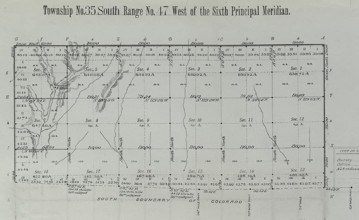
What the heck happened along the border between those two States beginning about 36 miles west of the southeast corner of Colorado (KS/CO/OK corner)? Do the stars not align correctly? Is there a big magnetic pull? Did the surveys come from both east and west and meet up here?
BTW, I bet there are darned few counties in the US that border four other States as well as a neighboring county in their home State. Cimarron County, Oklahoma holds that distinction thanks to a slightly less than one mile long common border with Kansas.
It looks like the south boundary of CO was surveyed prior to the sectional township surveys and they just followed previously set Mile Posts. This was in 1883. The 1894 Survey of the Cimarron Meridian merely closed on the existing CO survey....so once again it was somebody else's fault..not Oklahoma's!
😉
Holy Cow, post: 424198, member: 50 wrote: A question for Oklahoma and Colorado surveyors.
What the heck happened along the border between those two States beginning about 36 miles west of the southeast corner of Colorado (KS/CO/OK corner)?
Isn't that one of the places where there were multiple surveys and a Supreme Court decision leading to a resurvey? I followed a discussion of the Colorado-New Mexico boundary several years ago, and think I recall that the confusion went all the way from Oklahoma and Texas.
Aha, here is the folder of notes. Hope I got this straight.
The CO-NM line was surveyed in 1868 by Darling.
It was surveyed again in 1902
The dispute over which line to use was decided by the US Supreme Court 267 US 30 (1925) and a resurvey was ordered at 268 US 108.
This survey by Kidder set bronze caps in 1925, following essentially the 1868 survey, which was difficult because the 1902 survey had destroyed most of the monument, but he found sufficient evidence to follow the old notes.
Kidder didn't file his work with the court, perhaps due to health issues, and it wasn't until 1960 that Joseph C. Thoma gathered up the material and filed the repot so the court closed it out in 364 US 296, Dec 24, 1960.
Sorry I don't have the OK & TX notes.
That jog in the line Holy Cow referred to was very likely due to various attempts to locate the 37th parallel. The text in 267 US 30 mentions two monuments intended for the NE corner of New Mexico. You can see how not only was there a stretch of the CO-OK line that is quite irregular, the last mile or so before it reaches NM also veers to reach one of those monuments.
"Some years [after Colorado was admitted to the Union] the 103d meridian was established on a line known as the 'Cimarron Meridian,' intersecting the 37th parallel a short distance east of the Macomb monument. Thereafter the US Surveyor Geral employed Levi S. Preston, a deputy surveyor, to resurvey and retrace the north boundary of New Mexico between the Macomb monument and the Cimarron meridian. Preston made this survey in 1900, retracing and remarking this portion of the Major line, and established at the intersection of that line and the Cimarron meridian, about two miles east of the Macomb monument, a sandstone corner since known as the Preston monument."
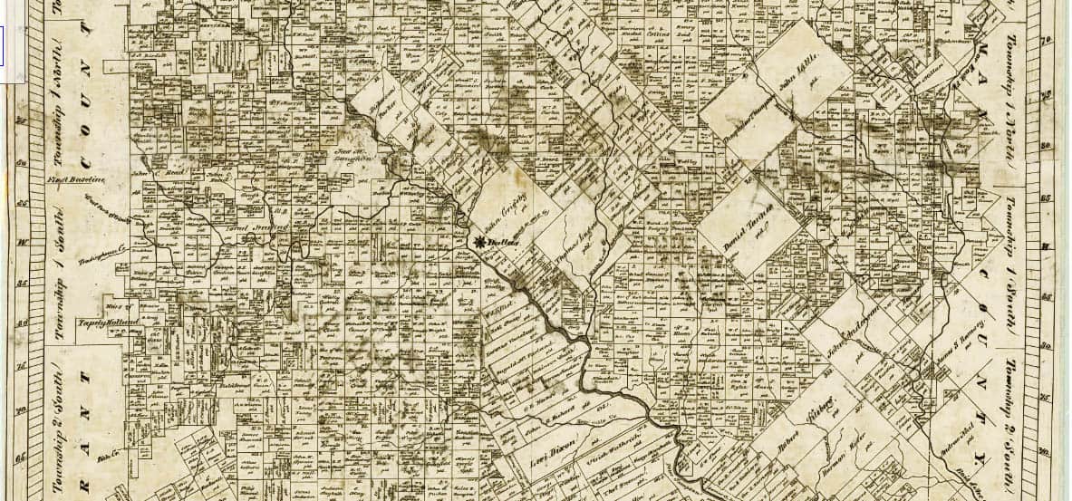
Kent McMillan, post: 423870, member: 3 wrote: The simplicity of the PLSS is striking to someone who practices in a metes and bounds system Compare the standard checkerboard of PLSSia to even a fairly regular pattern such as that of Dallas County, Texas where the positions of land grants are identified by polar coordinates, i.e. so many miles on a specified bearing from the point indicated as "Dallas" on the county map.
The idea that the PLSS is simpler died with Jefferson. There are places where the PLSS is simple, just like their are places in the colonial states and Texas that are simple, but to say that it is simpler is a sure sign it is not understood.
aliquot, post: 424237, member: 2486 wrote: The idea that the PLSS is simpler died with Jefferson. There are places where the PLSS is simple, just like their are places in the colonial states and Texas that are simple, but to say that it is simpler is a sure sign it is not understood.
Kent thinks in linear terms and his variables are his choosing. I would venture that in his dictates about the PLSS therein does lay some simplicity, but it is not in the subject matter.
There are difficult complexities in the retracement and maintenance of land lines within the PLSS. If one merely reads the BLM Manual of Instructions (which is the only reference I've ever heard Kent utter) there is a simplicity in the original fabric. But the Manual is only good for two things: Surveying Public Lands and use as a go-by when attempting a retracement of a survey WHEN the lands were Public Domain. Everything that has happened to that property since patent has a bearing on how a retracement is considered with a boundary survey.
From what I've determined, resurveying in Texas is probably a lot simpler than in Oklahoma. In Texas you can create new lines and ignore previous surveys with your own pincushions. And as much as Kent talks about records you would think he might try following them instead of spending thousands of the client's dollars attempting to rationalize why he doesn't actually honor existing boundary lines. But that is apparently what surveying in Texas is all about; coming up with new lines every time a survey is performed. According to what Kent has related to us the only reason one searches for existing corners is to work like the devil to come up with a different location and then berate the abilities, procedure and habits of the poor surveyor whose only mistake was being unlucky enough to have Kent follow behind him.
But I like Kent and his bull-headed tunnel vision. It's entertaining to listen to him make up stuff as he rolls along. His ability to create fiction rivals my own. 😉
paden cash, post: 424248, member: 20 wrote: But I like Kent and his bull-headed tunnel vision. It's entertaining to listen to him make up stuff as he rolls along. His ability to create fiction rivals my own. 😉
If Kent was a girl...
[USER=87]@Bill93[/USER]
Go to Google Earth and take a look at the corner of NM/CO/OK. Click on the 360 to check out the scenic panoramic view. It is immediately obvious what the problem is. The monument is a long way from the corner post that is separating New Mexico from the other two States. The view to the south and southwest is of Black Mesa which reaches out of Colorado across part of New Mexico and just barely into Oklahoma. The highest point in Oklahoma is about three miles south of the monument atop about the easternmost tip of the mesa..
The PLSS was really conceived as a simplified title system with a surveying component. It was supposed to be an improvement on "beginning at the northeast corner of Smith, thence..." Where in the heck is that?
At least the northeast quarter of the northwest quarter of STR can be approximately located on the map.
I really doubt the originators of the system thought we would still be refining the locations of aliquot lines 200 years later. Such an idea was foreign to their jurisprudence and is an invention of pettifogging engineers. The idea was their patent would touch at least one corner established by the GLO and the rest should be simple, right?
The difference between creation by document and establishment by the physical acts of the patentees is important.
paden cash, post: 424176, member: 20 wrote: Just a little tid-bit of info:
Theodore Barrett was one of several surveyors that contracted to survey the Indian and Oklahoma Territories after 1874. He apparently became enamored with the SW after his service as a Union officer during the War of Northern Aggression. Barrett was originally from Minnesota and had started his survey career there before joining Union forces. He retired there after his work down here. His notes and surveys are some of the best we have down here.
Now that's interesting. I haven't come across Barrett's name but, like everywhere else, there were a lot of individual surveyors working on the PLSS in Minnesota.
Barrett might have decided he liked the milder climate and dry ground in Oklahoma a lot better than chaining over frozen swamps. Winter surveys were common here, probably more than elsewhere, since it was easier to get across the thousands of lakes and wetlands in the winter. Of course it also made it easier to get frostbite and pneumonia.
RPlumb314, post: 424295, member: 6313 wrote: Now that's interesting. I haven't come across Barrett's name but, like everywhere else, there were a lot of individual surveyors working on the PLSS in Minnesota.
Barrett might have decided he liked the milder climate and dry ground in Oklahoma a lot better than chaining over frozen swamps. Winter surveys were common here, probably more than elsewhere, since it was easier to get across the thousands of lakes and wetlands in the winter. Of course it also made it easier to get frostbite and pneumonia.
I wrote an article for a publication a number of years back about Barrett. And I apologize for not keeping it around. The interesting thing was one of Barrett's great-grandsons contacted me after he had found the article and was amazed to discover the history. Sometime in the past one of Barrett's kin had donated a collection of misc. notes and fodder to our Oklahoma Historical Society including a pristine mint hardback copy of the one of the first Manual of Instructions. His great grandson had never heard of the collection.
John Thompson, post: 424069, member: 9631 wrote: My question is why did the Surveyor General choose spacings of 4 townships north and 5 townships south for standard parallels.
That is what the 1851 Oregon Manual calls for. The reason for that is not stated, but it probably had to do with a need to get on with the surveying of the Willamette Valley very quickly, as the place was already well settled and filling up fast. I suppose that the 1851 manual may have been in use in parts of Kansas where that method was also used.
paden cash, post: 424248, member: 20 wrote: Kent thinks in linear terms and his variables are his choosing. I would venture that in his dictates about the PLSS therein does lay some simplicity, but it is not in the subject matter.
There are difficult complexities in the retracement and maintenance of land lines within the PLSS. If one merely reads the BLM Manual of Instructions (which is the only reference I've ever heard Kent utter) there is a simplicity in the original fabric. But the Manual is only good for two things: Surveying Public Lands and use as a go-by when attempting a retracement of a survey WHEN the lands were Public Domain. Everything that has happened to that property since patent has a bearing on how a retracement is considered with a boundary survey.
From what I've determined, resurveying in Texas is probably a lot simpler than in Oklahoma. In Texas you can create new lines and ignore previous surveys with your own pincushions. And as much as Kent talks about records you would think he might try following them instead of spending thousands of the client's dollars attempting to rationalize why he doesn't actually honor existing boundary lines. But that is apparently what surveying in Texas is all about; coming up with new lines every time a survey is performed. According to what Kent has related to us the only reason one searches for existing corners is to work like the devil to come up with a different location and then berate the abilities, procedure and habits of the poor surveyor whose only mistake was being unlucky enough to have Kent follow behind him.
But I like Kent and his bull-headed tunnel vision. It's entertaining to listen to him make up stuff as he rolls along. His ability to create fiction rivals my own. 😉
You suggesting that Texas is a MATH state?
paden cash, post: 424248, member: 20 wrote: Kent thinks in linear terms ... From what I've determined, resurveying in Texas is probably a lot simpler than in Oklahoma. In Texas you can create new lines and ignore previous surveys with your own pincushions. And as much as Kent talks about records you would think he might try following them instead of spending thousands of the client's dollars attempting to rationalize why he doesn't actually honor existing boundary lines. But that is apparently what surveying in Texas is all about; coming up with new lines every time a survey is performed. According to what Kent has related to us the only reason one searches for existing corners is to work like the devil to come up with a different location and then berate the abilities, procedure and habits of the poor surveyor whose only mistake was being unlucky enough to have Kent follow behind him.
But I like Kent and his bull-headed tunnel vision. It's entertaining to listen to him make up stuff as he rolls along. His ability to create fiction rivals my own. 😉
Are you serious or delirious or both?
Or are you campaigning for rplstoday nation president using these comments. Y
I know there are a few popular posters here who like to call out Kent at times for whatever but this is loco.:bomb:
Robert Hill, post: 424326, member: 378 wrote: Are you serious or delirious or both?
Or are you campaigning for rplstoday nation president using these comments. Y
I know there are a few popular posters here who like to call out Kent at times for whatever but this is loco.
Merely an exercise to see if I could rag on Kent's PLSS near-sightedness and NOT get a 'corrective' reply.
So it either worked...or Kent has been to busy to notice it at all. 😉
paden cash, post: 424328, member: 20 wrote: Merely an exercise to see if I could rag on Kent's PLSS near-sightedness and NOT get a 'corrective' reply.
So it either worked...or Kent has been to busy to notice it at all. 😉
Why would anyone respond to that blathering?
Maybe you should call him and read it to him...I think that he is open to being contacted
Robert Hill, post: 424335, member: 378 wrote: Why would anyone respond to that blathering?
Maybe you should call him and read it to him...I think that he is open to being contacted
I guess maybe the pH of the Oklahoma/ Texas banter in my post appears to you to be a little acidic. Hopefully my blather is taken by Kent in the same levity as it was written. It really wasn't meant to be anything but tongue-in-cheek in the same perspective as Kent's open and obvious opinions about surveying in Oklahoma...or how we skirt our trailer houses up here.
I understand the cultural arrows but the surveying darts tend to confuse me
In Kennedistan, we don' need no steenkin' baselines or meridians.

Exactly where in Great Britain would we find that oddly-shaped smattering of real estate? I recognize quite a number of English placenames but they don't seem to be in their standard geographical positions. I think you could put all of that inside Brewster County, Texas...................not that you would ever want to do that for obvious reasons..............but, it could be done.
Dang it. Just proved myself wrong. Brewster County, Texas has an area of 6192 square miles which is significantly less than the 10565 square miles claimed by Massachusetts. It is, however, significantly larger than Connecticut and its 5543 square miles.


