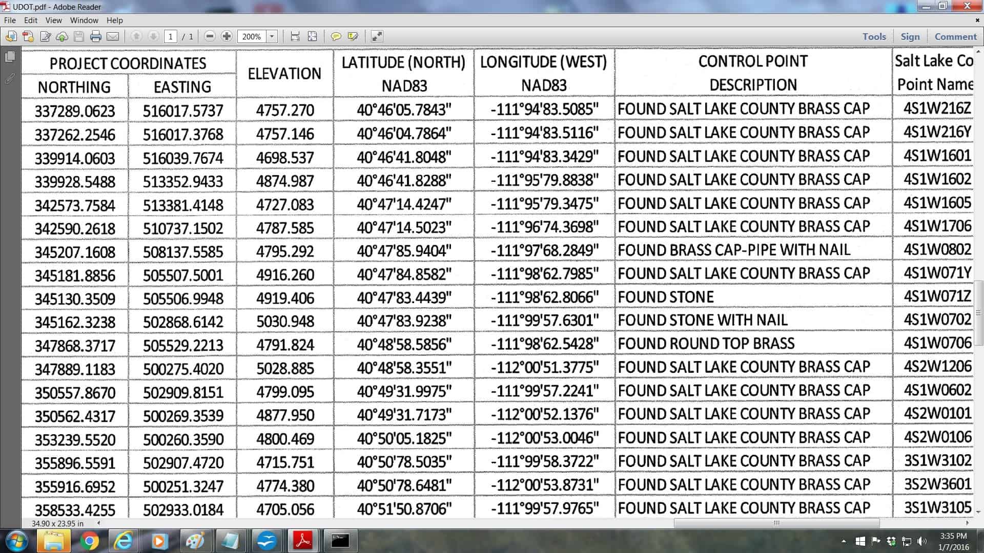
Please excuse my ignorance... is there something objectionable here?
Funky longitudes.
Loyal, post: 352194, member: 228 wrote: A screen shot from a RECENT UDOT "Control Sheet" (a recorded document in the County Surveyors ROS database).
[sarcasm]Just a standard Utah deed gap. Gotta be careful, might fall in! Might have been a long day, 94 minutes in an hour. Seconds out of wack also, somebody needs to check their spreadsheet or software.[/sarcasm]
Nice piece of plat CHECKING before recording...
40å¡46'05.7843" is really 40.46057843å¡ or 40å¡27'38.08235"
and
111å¡94'83.5085" is really 111.94835085å¡ or 111å¡56'54.06306"
You would think that somebody would have caught that BEFORE recording it for all to see!
Loyal, post: 352194, member: 228 wrote: A screen shot from a RECENT UDOT "Control Sheet" (a recorded document in the County Surveyors ROS database).
do you think those longitudes are correct if they are treated as decimal numbers?
most of the latitudes look ok but there are a few..........
maybe they are all decimal
Longitudes are West and negative therefore they are East.
Loyal, post: 352211, member: 228 wrote: Nice piece of plat CHECKING before recording...
40å¡46'05.7843" is really 40.46057843å¡ or 40å¡27'38.08235"
and
111å¡94'83.5085" is really 111.94835085å¡ or 111å¡56'54.06306"You would think that somebody would have caught that BEFORE recording it for all to see!
The odd thing about it; is using any program I know of it would be an effort to make a decimal number look like that, it's not something easy to do................
Someone went in there and added the degree symbol, the minute symbol, the second symbol and moved the dot, seems like a lot of work to make something be that wrong.
[sarcasm]Makes you wonder if they got the coordinates from Google Earth.[/sarcasm]
A good example of something that probably happens a lot more than we'd like to admit.
Being my own CAD tech, I generally get a good look at everything that goes out "to be recorded". I'm sure there are organizations that leave the "paperwork" preparation of required record filing up to staff. The results are obvious. I've seen corner records from good surveyors that had junk on it like that. When I call them most will admit that the tech prepared the doc and "All I did was sign it".
...tsk, tsk....be more careful!!
LOL!! Not sure how I missed 90'+ longitudes, must have been a long day yesterday.
What are the Northing and Easting coordinates? if they are SPC, what Zone and year? Are they feet or meters? Probably feet looking at the values, but to 4 decimal places?
All in all, extremely useless except s a bad example.
Mighty Moe,
A spreadsheet formula could easily insert å¡ ' " moving the decimal points, if you use 100 and not 60 as the multiplier.
Paul in PA
Paul in PA, post: 352297, member: 236 wrote: What are the Northing and Easting coordinates? if they are SPC, what Zone and year? Are they feet or meters? Probably feet looking at the values, but to 4 decimal places?
All in all, extremely useless except s a bad example.
Mighty Moe,
A spreadsheet formula could easily insert å¡ ' " moving the decimal points, if you use 100 and not 60 as the multiplier.
Paul in PA
Yes, it could, but think about it, you have a dd.ddddddd number you created somehow, then you change it into into a ddodd'dd.dddd" number.
Anyway, it's an odd number to create taking what is a good one and making it a weird one.
I can see it happening the other way many programs have a decimal like this dd.mmsssssss those are easy to change from a dms number into a dd.ddddd number
as far as the decimal points DOT (not Utah, I don't know their standards) requires 3 decimal places for meters and 4 decimal places for feet, I can't explain it, it's in the standards.B-)
So my guess without checking is that those are feet numbers on a working plane of some kind.
I tried treating the lat/lon as decimal degrees, disregarding the minutes and seconds symbols, and converting to Utah North SPC feet.
The difference between SPC and their Northing/Easting is on the gross order of what you get by dropping the millions of feet, so I was going to find out exactly what offset would match them up.
There is something seriously different about the first two entries relative to the next 10 (I stopped there). Those first two show a coordinate offset between systems that is about a quarter mile different from the next 10.
And it's not just a scale and offset operation (or vice versa). No choice of two parameters will match those 10 points up better than a couple feet.
If you take the difference between the northing (or in easting) of two points in their system and the difference in SPC, the ratio of those distances is not at all constant. Maybe they did a custom projection? That ratio is not a smooth curve versus the northing (or easting). Maybe I have to consider N and E together in the transformation, or maybe they didn't do an accurate transformation of any kind (even aside from the first two points).
Bill,
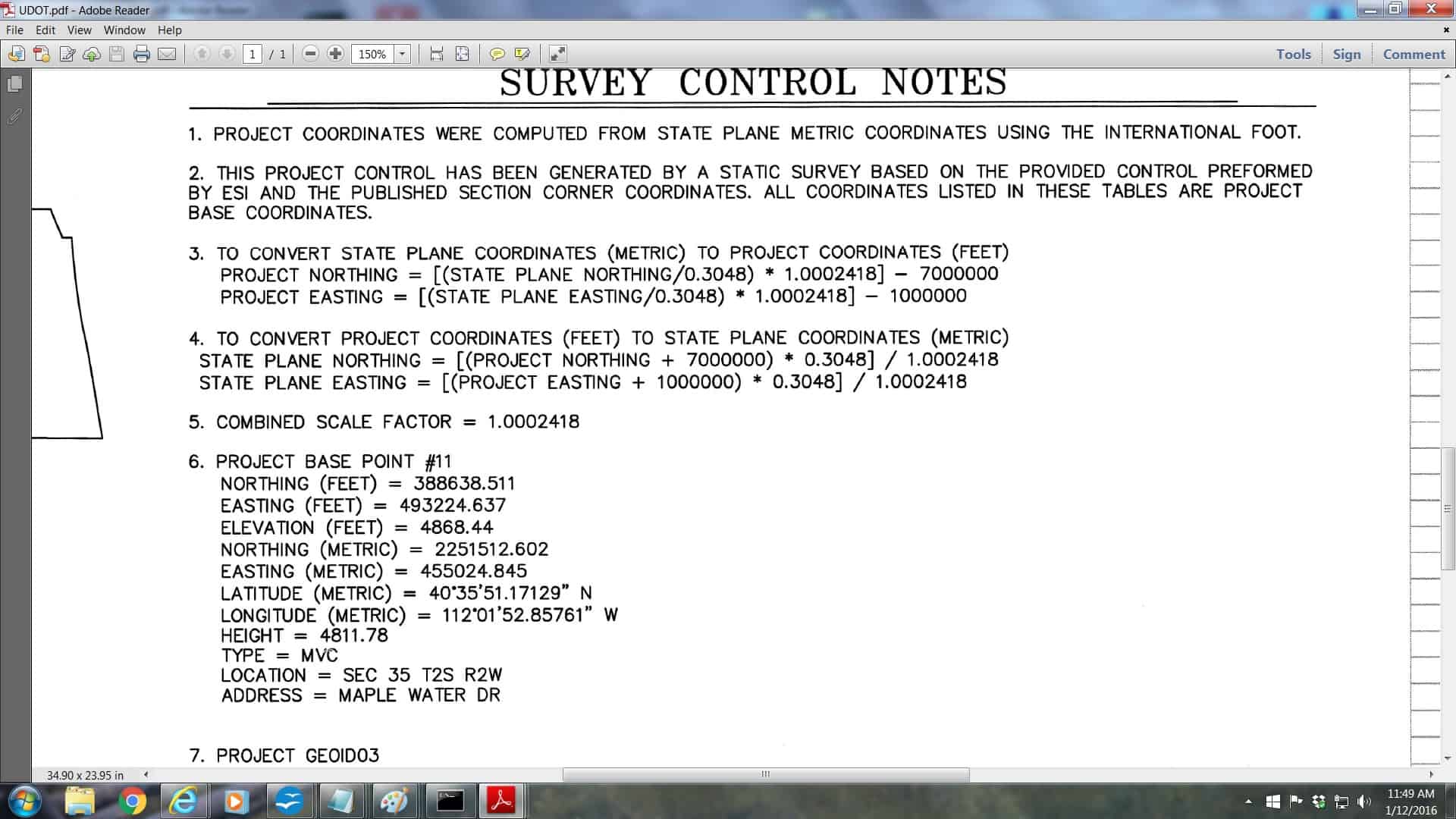
See page 27 of the attached document. "COMPUTING PROJECT COORDINATES FROM STATE PLANE"
DDSM:beer:
Bill93, post: 352670, member: 87 wrote: I tried treating the lat/lon as decimal degrees, disregarding the minutes and seconds symbols, and converting to Utah North SPC feet.
The difference between SPC and their Northing/Easting is on the gross order of what you get by dropping the millions of feet, so I was going to find out exactly what offset would match them up.
There is something seriously different about the first two entries relative to the next 10 (I stopped there). Those first two show a coordinate offset between systems that is about a quarter mile different from the next 10.
And it's not just a scale and offset operation (or vice versa). No choice of two parameters will match those 10 points up better than a couple feet.
If you take the difference between the northing (or in easting) of two points in their system and the difference in SPC, the ratio of those distances is not at all constant. Maybe they did a custom projection? That ratio is not a smooth curve versus the northing (or easting). Maybe I have to consider N and E together in the transformation, or maybe they didn't do an accurate transformation of any kind (even aside from the first two points).
I can't make any sense out of them either, using decimal degrees they don't match up with the coordinates, it's not a meter-feet thing, it's not a truncated number thing........
It looks like lots of fun.
It's like a puzzle, maybe Loyal figured it out
From the doc Dan posted, it looks like they want to use a combined factor and a XY shift on top of it, that is something that can be done in many computer programs, not a big deal but there has to be good metadata for it.
At 5000' feet the scale factors get a bit large for highway work so they like project coordinates.
Looks like there's all sorts of wrong with that list. Here's the published reference sheet for monument 4S1W216Z (the first one on the list). Looks like they're using a project scale factor of 1.0002438 and have dropped 7M from the Northing and 1M from the Easting. (How they came up with that SF is beyond me). Don't know if they're using USFt or IFt. Neither one makes any sense when looking at the Lat/Lon.
Note that point says Utah Central zone. We're really close to the zone boundary here and headed north as we go through the list. Do some of the points fall in the Northern zone? That would add a confusion factor for someone who didn't understand what they were doing.


