Sorry, Kent, this one is strictly for the PLSSia surveyors.
Here's the scenario. You are working in a section that has a line crossing it that created a situation where the Government survey of the section was carried out in two steps. One side of the line was surveyed a year or two earlier than the remainder of the section on the other side of the line. Two different contractors. Two different survey crews. Two different times of year. Maybe they did things identically and maybe they didn't. There is no way to know.
Anyone who has ever worked with this type of section knows to expect a kink in the section line where it intersects the "line" that separated the two surveys.
To keep it simple, let's look at only one line, say the north section line. The northwest corner, north quarter corner and northeast corner all have monuments, but none are original and were set by three different surveyors working on surveys in adjoining sections but in such a way as to have no need to worry about the "line" and the kink that should occur. The process of how those monument locations were selected appears to be based on physical evidence only, such as apparent road center lines, fences, etc. The Government field notes report that when the survey on one side of the line was carried out they missed the mile post on the "line" by a few links, so returned on a bearing of something like South 89 degrees 58 minutes West. Similarly, the survey on the other side reports missing the mile post by a few links resulting in a return bearing of something like South 89 degrees 57 minutes East.
The location of the "kink", if one were to exist, has nothing physical suggesting its precise location in both the north-south orientation or the east-west orientation. In a perfect world, the distance from the quarter corner to the section corner would match precisely with the sum of the two record measurements from the Government surveys. That never happens. If one applies the two bearings provided above as being perfect, the kink amounts to roughly one foot off of a straight line between the quarter corner and the section corner.........or maybe it's more like fifteen feet. Keep in mind that a link was the default precision reported. Also, consider that the relative angle between the two line segments was never determined. One surveyor said "This way is due east" and a different surveyor a year or two later earlier said, "This is due west". Maybe the mile post was precisely the same thing in the same place a couple years apart 150 years ago and maybe it wasn't. Fiction is fairly common in the writings of the contractors from that era in the area around the subject section. The measurements between the current monuments differs quite substantially from record.
Here's the challenge. How to pinpoint the correct location of the intersection of the "line" with the north section line.
Assume the section corner to quarter corner dimension compares to the standard 40 chains reported and proportion the extension of that line out by the number of chains and links reported in that survey to reach the "line"?
Assume the distance from the quarter corner and the section corner on the side where the "line" crosses represents the total reported distance of say 40.08 chains and use the measured distance to proportion where the "line" was based on the two record distances totaling to 40.08 chains?
Using the first method produces a kink far in excess of the reported difference in bearings. In fact, it falls fifteen feet from where physical evidence suggests it should be.
Using the second method and applying the difference between the two stated bearings produces the kink of only about one foot mentioned above.
Using a third method could be argued as beneficial. That being to forget about the kink altogether and simply straight line between the quarter section corner and the section corner.
Gosh. I don't know why I'm asking you guys about this. Everything in PLSSia is so incredibly simple. There can only be one solution..........right????
Easy, peasy Cow. Just consult the Manual. Like these two gems (the second is obviously my favorite):
The restoration should then be made by the method most nearly in harmony with the official plat(s). No general rule can be advanced.
There is no hard and fast rule for reestablishing lost corners to lode mining claims. The method should be selected that will give the best results...
🙂
Holy Cow, post: 426612, member: 50 wrote: Sorry, Kent, this one is strictly for the PLSSia surveyors.
Gosh. I don't know why I'm asking you guys about this. Everything in PLSSia is so incredibly simple. There can only be one solution..........right????
Evidently you need me to point out that example you give is a rare one in PLSSia, so I will.
Gene Kooper, post: 426619, member: 9850 wrote: Easy, peasy Cow. Just consult the Manual.
I'd say consult the field notes. Duplicate what (say) they did.
Mark Mayer, post: 426621, member: 424 wrote: I'd say consult the field notes. Duplicate what (say) they did.
I guess I needed to employ multiple smilies, Mark.
So sayeth the Cookbook. Amen.
Kent McMillan, post: 426620, member: 3 wrote: Evidently you need me to point out that example you give is a rare one in PLSSia, so I will.
It's not rare at all. Any time one survey closed on any number of different n-s senior lines this occurs. Those senior lines can be anything from government military boundaries, political boundaries, tribal boundaries or even lines where the survey was terminated due to inhospitable topographic relief. The latter not so much because the surveyors couldn't survey it; but because Washington wanted lands suitable for agricultural interests surveyed primarily.
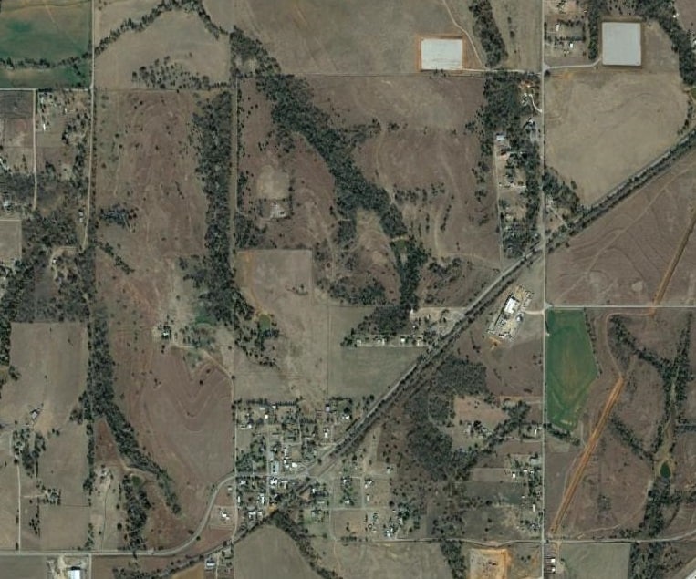
I do a lot of work in Grady County, OK. The 98th. Meridian was designated in this area as the west boundary of Indian Territory and the east boundary of the Oklahoma Territory. It was also the west boundary of the Ft. Reno military reserve. And interestingly the statutory R/W east of the 98th. Meridian is only one chain total. West of the 98th. Meridian it's two chains. And no, the east-west section lines don't necessarily converge (or diverge) on the Meridian at the same place.
Those with an eye for section lines might be able to distinguish the 98th. Meridian on this aerial of the little hamlet of Norge, OK.
Or possibly the township I was working in earlier in the week where I took the pic of the old hay rake, 8N7WIM; In 1872 T. Barrett turned in something that looked like this:
Then in 1899 the USGS turned in something that looked like this:
THEN...1 year later the USGS decided the old 98th. Meridian wasn't where it was supposed to be. They came back, obliterated the senior line (on paper) and moved it to the west a few arc seconds:
Luckily in this area the line only moved a chain or two. Unluckily it was after the lands to the east had been patented. In counties to the north the difference approached 10 chains.
And to address HC's original question: yes the e-w section lines look like they line up...no they don't...by a couple of chains (see the aerial of Norge, OK above). The only thing I cab tell you about your specific area is "it all depends"....mainly on how they did it originally. You just have to do your best to retrace both sides,
And to address Kent and his remark about this being an obvious rarity: it's not by any means.
But of course Kent already knew all of this anyway seeing how it's so simple.
Maybe I should consult with Keith Williams on exactly how to factor in the imaginary curve associated with the two stubbed in lines.
The amazing thing is that the first line run, that being from the southeast corner going west, hit the mile post dead on. Not even a one link miss. Then they ran a perfect 80 going north. Then they ran west and missed by two links. Remember, although that was about 1867, the mile posts may have been set as early as 1825. I rarely use the word "phenomenal" but, Baby, "THAT'S PHENOMENAL". Also, the sum of the number of chains on the south section line is 80.01 chains and the north section line is 80.03 chains. Baby, "THAT'S PHENOMENAL". Now, guess what, the supposed 40.03 on the north measures 39.51 these days and the supposed 40.01 on the south measures 39.21 these days. That sort of further complicates any attempt to believe the notes.
The DOT worked one of the lines and decided there was absolutely no kink. Just sayin'.
paden cash, post: 426625, member: 20 wrote: It's not rare at all.
[...]
Or possibly the township I was working in earlier in the week where I took the pic of the old hay rake, 8N7WIM; In 1872 T. Barrett turned in something that looked like this:
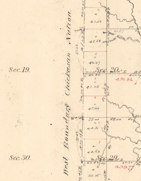
Then in 1899 the USGS turned in something that looked like this:
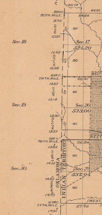
THEN...1 year later the USGS decided the old 98th. Meridian wasn't where it was supposed to be. They came back, obliterated the senior line (on paper) and moved it to the west a few arc seconds:
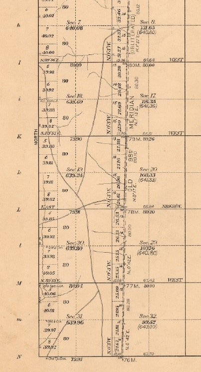
Luckily in this area the line only moved a chain or two. Unluckily it was after the lands to the east had been patented. In counties to the north the difference approached 10 chains.And to address Kent and his remark about this being an obvious rarity: it's not by any means.
But of course Kent already knew all of this anyway seeing how it's so simple.
Well, how many PLSS townships would you imagine were extensively revised by the US Geological Survey or contain tribal reservations appropriated prior to the survey of the township? If your point is that Oklahoma is a bit of a mess, I don't think that was ever at issue, but you're still dealing with a quite limited number of original systems of surveys even in the messed-up township. Presumably the USGS left lots of monuments behind in their work and even did you the favor of plotting their locations with respect to topography. So, it that's head-busting difficulty, what does simplicity look like?
Topography?????? There must be topography and stuff to reference to or it can't be done.
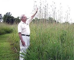
"N47E 18 lks to a clump of Giant Bluestem" never appears in our Field Notes
The man in the photo assists in showing the height to which this grass grows. Early reports from our area detail a dense ocean of such grass as far as a man could see while standing on horseback. Damned tough to stay on line and keep a tight, unbending chain going through miles of such grass with nothing to use to keep one's bearings on a cloudy day.
[MEDIA=youtube]rAlTOfl9F2w[/MEDIA]
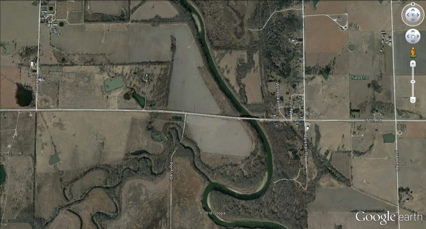
Stubbed out sections are more numerous than one might think. Adding into the fun are the cases where quite clearly what was done and what was written are two very different things. A prime example being the situation where a significant river exists. Most of the time, the notes report they crossed directly over the river and returned to correctly locate a north or south quarter corner. Take a look in Google Earth and you can see what really happened because the sections to the east of the river don't line up with the sections to the west of the river.
The road going North on the left is Kiowa. Two miles to the east, near the right side, is Meade. One-half mile west of Meade is Marshall. 150th is the road running from east to west. The section corner one mile east of the intersection of Kiowa and 150th is about 200 feet north of the center of 150th a short distance to the east of where Liberty comes in from the south. Projecting that line eastward would suggest that 150th should be nearly 400 feet north of its actual location on the east side of the river for a quarter corner to have been set about where the first little street is visible going west from Marshall and on the center line of Marshall. This is not an isolated incident as the river enters the county a few miles east of the northwest corner and exits a few miles west of the southeast corner. That's 25 section line/river crossings that were not performed as written in the Field Notes.
Kent McMillan, post: 426641, member: 3 wrote: Well, how many PLSS townships would you imagine were extensively revised by the US Geological Survey or contain tribal reservations appropriated prior to the survey of the township? If your point is that Oklahoma is a bit of a mess, I don't think that was ever at issue, but you're still dealing with a quite limited number of original systems of surveys even in the messed-up township. Presumably the USGS left lots of monuments behind in their work and even did you the favor of plotting their locations with respect to topography. So, it that's head-busting difficulty, what does simplicity look like?
Kent, please stop. Everytime you make comments like this it becomes clearer and clearer that you don't understand surveying in the PLSS. I enjoy your posts about surveying in Texas, I don't always agree with you, but you clearly know a lot about it.
Unfortunatly there are a lot of surveyors in PLSS states who share the simplistic beliefs about it that you do. These are the people screwing up boundaries and giving surveyors a bad name because each one has a differnent opinion on where a section corner is. These are the people who file corner records with no explanation of why they set a mag nail where they did. This is the kind of thing we need to get away from if we are going to survive as a respected well paid proffesion.
[USER=378]@Robert Hill[/USER]
That's a great one! I bet Louisiana topography notes are entertaining, too. "N 47 E 18 lks to edge of swamp"
Holy Cow, post: 426612, member: 50 wrote: Sorry, Kent, this one is strictly for the PLSSia surveyors.
Here's the scenario. You are working in a section that has a line crossing it that created a situation where the Government survey of the section was carried out in two steps. One side of the line was surveyed a year or two earlier than the remainder of the section on the other side of the line. Two different contractors. Two different survey crews. Two different times of year. Maybe they did things identically and maybe they didn't. There is no way to know.
Anyone who has ever worked with this type of section knows to expect a kink in the section line where it intersects the "line" that separated the two surveys.
To keep it simple, let's look at only one line, say the north section line. The northwest corner, north quarter corner and northeast corner all have monuments, but none are original and were set by three different surveyors working on surveys in adjoining sections but in such a way as to have no need to worry about the "line" and the kink that should occur. The process of how those monument locations were selected appears to be based on physical evidence only, such as apparent road center lines, fences, etc. The Government field notes report that when the survey on one side of the line was carried out they missed the mile post on the "line" by a few links, so returned on a bearing of something like South 89 degrees 58 minutes West. Similarly, the survey on the other side reports missing the mile post by a few links resulting in a return bearing of something like South 89 degrees 57 minutes East.
The location of the "kink", if one were to exist, has nothing physical suggesting its precise location in both the north-south orientation or the east-west orientation. In a perfect world, the distance from the quarter corner to the section corner would match precisely with the sum of the two record measurements from the Government surveys. That never happens. If one applies the two bearings provided above as being perfect, the kink amounts to roughly one foot off of a straight line between the quarter corner and the section corner.........or maybe it's more like fifteen feet. Keep in mind that a link was the default precision reported. Also, consider that the relative angle between the two line segments was never determined. One surveyor said "This way is due east" and a different surveyor a year or two later earlier said, "This is due west". Maybe the mile post was precisely the same thing in the same place a couple years apart 150 years ago and maybe it wasn't. Fiction is fairly common in the writings of the contractors from that era in the area around the subject section. The measurements between the current monuments differs quite substantially from record.
Here's the challenge. How to pinpoint the correct location of the intersection of the "line" with the north section line.
Assume the section corner to quarter corner dimension compares to the standard 40 chains reported and proportion the extension of that line out by the number of chains and links reported in that survey to reach the "line"?
Assume the distance from the quarter corner and the section corner on the side where the "line" crosses represents the total reported distance of say 40.08 chains and use the measured distance to proportion where the "line" was based on the two record distances totaling to 40.08 chains?
Using the first method produces a kink far in excess of the reported difference in bearings. In fact, it falls fifteen feet from where physical evidence suggests it should be.
Using the second method and applying the difference between the two stated bearings produces the kink of only about one foot mentioned above.
Using a third method could be argued as beneficial. That being to forget about the kink altogether and simply straight line between the quarter section corner and the section corner.
Gosh. I don't know why I'm asking you guys about this. Everything in PLSSia is so incredibly simple. There can only be one solution..........right????
Without seeing this completion survey I would say the plat controls, except when it doesn't;)
Kent McMillan, post: 426641, member: 3 wrote: ...So, it that's head-busting difficulty, what does simplicity look like?
Simplicity looks like this:
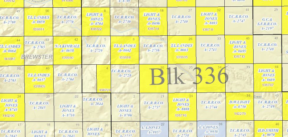

Where squares were drawn and indicated with no thought of uniformity, convergence or corrections. They're just THERE. And the simplicity is a function of the resurvey also: every surveyor sets new corners with little or no regard for any previous work. Discovery of previous surveys is apparently usually an afterthought to give one something to refute. This gives the appearance of adherences to due diligence and justifies the lofty invoices sent to clients that include time for side excursions and photo ops.
What could be simpler? Go set some corners, write a report stating the last guy was wrong and send invoice.
If this is the most difficult survey problem in PLSS, then you guys really do have it easy. First you have the Senior line, Second you have a manual to tell you how to solve the problem, you have recorded field notes, you have examples in the past on how to solve this problem in all of the PLSS states, I am sure they is a court case or two to help out as well.
Please try again with a more difficult problem. To me it seems any Survey who know what he is doing can solve this problem with all the resources available.
Trying to survey submerged lands and who owns the mineral and surface rights is more difficult than two lines not matching up in the PLSS pretty squares.
paden cash, post: 426657, member: 20 wrote: Simplicity looks like this:


Where squares were drawn and indicated with no thought of uniformity, convergence or corrections. They're just THERE. And the simplicity is a function of the resurvey also: every surveyor sets new corners with little or no regard for any previous work. Discovery of previous surveys is apparently usually an afterthought to give one something to refute. This gives the appearance of adherences to due diligence and justifies the lofty invoices sent to clients that include time for side excursions and photo ops.What could be simpler? Go set some corners, write a report stating the last guy was wrong and send invoice.
It's following in the footsteps of the original surveyor, and in some cases the next surveyor who was authorized to correct or supplement the original survey. In the sectionalized lands of west Texas, the original surveyors didn't necessarily leave a lot of monuments. You have to figure out what controls and you have to recognize that there are a lot of surveyors who didn't take the time to understand how the original work was done. The people who assume everything is 5280 square on the cardinal bearings. It takes research and field work. When there are 3 purported corners with a 120 foot spread, you've got to know how to reconstruct the block correctly and you have to able to discern the true corner from the goat stakes.
For those addicted to "the Cookbook", all of this land left Government ownership prior to 1870. That introduces some interesting quirks as well.
