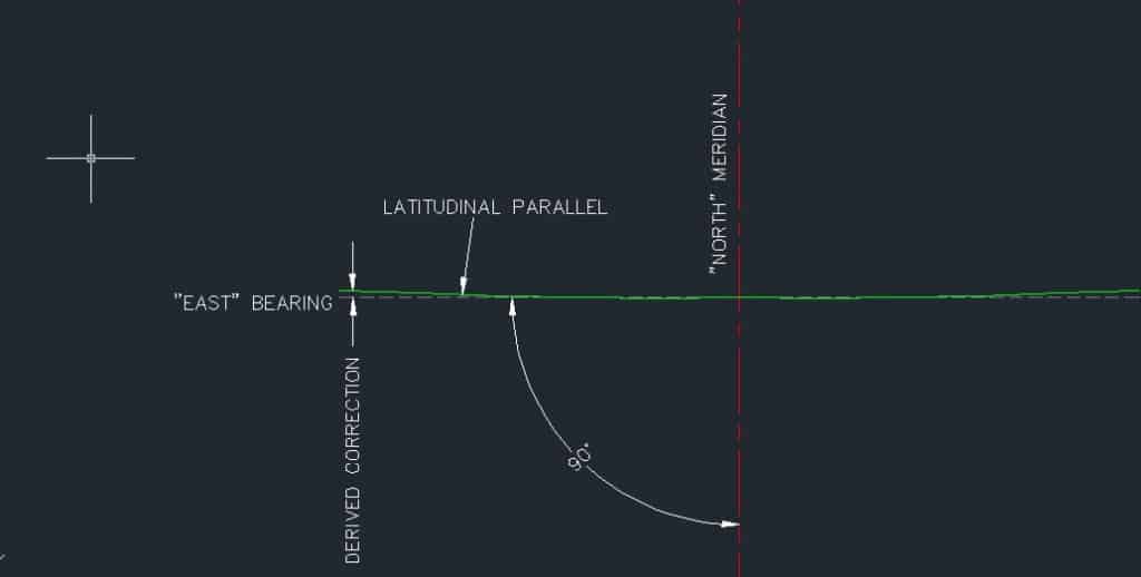
Andy, I might be missing something also, but a due "east" bearing and a latitudinal line are different animals. It sounds like you're wanting to traverse on a due east bearing and stay on the same latitudinal line. I don't think that's possible, that is why we correct, I believe. Someone correct me if I'm wrong, I barely squeeked through those chapters....
Because when you move east or west there is convergence of the meridians. If you have two points several miles apart on the same latitude the difference between the forward azimuth of the line and the back azimuth of the line is about Delta Longitude *sin(latitude) (true on a sphere, close approximation over short distances). So, when you go some distance you are no longer going east-west
The instructions for my reconstruction are to set block corners at 6 miles on the arc. The section corners inbetween are set on straight lines between the block corners. It's the Texas New Mexico State line at 32å¡ Latitude North. If you're not surveying on the arc, you aren't staying on the state line.
If you are headed east, at some point you will make it all the way around the world to where you started at. There is no convergence of meridians to consider because I am not going north or south. I am headed east on a parallel. Which is a circle if you look at it from the top. And an arc if you deal with it in six mile chunks.
I only finished the 2 year surveying program which dealt primarily with plane surveying. Perhaps I need to go back and finish the bachelor's degree.
If you always go exactly east, then you are on a great circle and will not follow the parallel of latitude.
Hold a string on a globe. One thumb on your location, and the other partway around the globe. Adjust until the string at the first thumb is due east or west and see where the other end is.
I always thought East was perpendicular to North and by definition has to be an arc. I'm having a hard time believing that a line of latitude is not consistent with that definition.
Andy Nold, post: 327259, member: 7 wrote: I always thought East was perpendicular to North and by definition has to be an arc. I'm having a hard time believing that a line of latitude is not consistent with that definition.
Andy,
Here's a simplistic sketch of what is really going on. And yes, it is hard for me to get my mind right also when dealing with such matters!
Come on, Paden. We've already established what I am trying to do and it looks like Page 129. I'm not doing local east or east bearing. I need to calculate a point 6 miles from and on the same latitude as a known monument. The formulas that I have looked at drop me down off of the line of latitude. That seems wrong especially when the instructions from the court case in the 1950s tell me that the block corners are ON THE ARC. If I were to hold the "EAST BEARING", I wouldn't be on the arc anymore. I am trying to figure out why the NGS program is lowering the latitude. Not trying to be a crank but man this project has been dogging me for a while now.
East on grid will continually diverge from a circle of latitude. That isn't really the original issue.
The important question in this case is 'how did the original surveyor compute his offsets' to stay on the Statutory line.The field notes won't likely tell you directly. The numbers should reveal the method used.
No, the court order says how to reconstruct. The original surveyor was substantially lacking in his field work. Not saying it was an office survey, but the controlling monuments recovered for a 30,720 acre survey block consists of 6-10 monuments that are very far apart and one of the monuments is the state line, which is an arc.
I'm going to set this project in the compost pile for awhile and come back to it later. I've spent way too much time on it in the past 2 days.
 And for your enjoyment, a quick sketch of the particular block I am working on. Block 55, Twp. 1 & 2, T&P Ry Co Survey.
How about...
Texas SPC 4203 in meters
6 miles West  3,264,200.570 359,824.849
Initial Point 3,263,892.512 369,476.340
6 miles East  3,263,593.320 379,128.110
  First  Station : West
   ----------------
LAT =  32  0  0.57550 North
LON = 103 56  1.84564 West

  Second Station : Center
   ----------------
LAT =  32  0  0.57550 North
LON = 103 49 53.96752 West

  Forward azimuth		FAZ =  89 58 22.5267 From North
  Back azimuth		   BAZ = 270  1 37.4733 From North
  Ellipsoidal distance	 S =	  9656.0827 m
  First  Station : Center
   ----------------
LAT =  32  0  0.57550 North
LON = 103 49 53.96752 West

  Second Station : East
   ----------------
LAT =  32  0  0.57550 North
LON = 103 43 46.08939 West

  Forward azimuth		FAZ =  89 58 22.5267 From North
  Back azimuth		   BAZ = 270  1 37.4733 From North
  Ellipsoidal distance	 S =	  9656.0830 m
kind of a quick and dirty solution, assumes [zero] ellipsoid height, and needs a little tweaking.
Loyal
Andy Nold, post: 327273, member: 7 wrote: No, the court order says how to reconstruct. The original surveyor was substantially lacking in his field work. Not saying it was an office survey, but the controlling monuments recovered for a 30,720 acre survey block consists of 6-10 monuments that are very far apart and one of the monuments is the state line, which is an arc.
I'm going to set this project in the compost pile for awhile and come back to it later. I've spent way too much time on it in the past 2 days.
Interesting. What Court if you don't mind me asking?
Andy Nold, post: 327252, member: 7 wrote: The instructions for my reconstruction are to set block corners at 6 miles on the arc. The section corners inbetween are set on straight lines between the block corners. It's the Texas New Mexico State line at 32å¡ Latitude North. If you're not surveying on the arc, you aren't staying on the state line.
If you are headed east, at some point you will make it all the way around the world to where you started at. There is no convergence of meridians to consider because I am not going north or south. I am headed east on a parallel. Which is a circle if you look at it from the top. And an arc if you deal with it in six mile chunks.
I only finished the 2 year surveying program which dealt primarily with plane surveying. Perhaps I need to go back and finish the bachelor's degree.
Absolutely the convergence of the meridians enters into this. If you were going due north or due south then and only then would there be no meridian convergence.
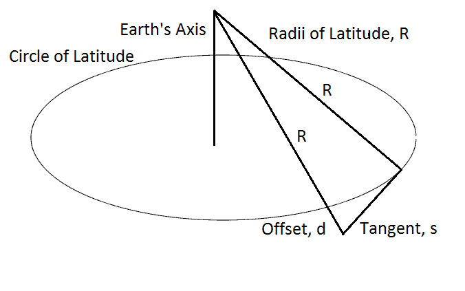
This little diagram shows what's going on. It is the geometry that produces the numbers in Paden's table. Warning: you have to think in 3 dimensions in order to understand the diagram.
When the old surveyors wanted to stay on a latitude, they measured tangents to the latitude. In the diagram, you see the circle (parallel) of latitude and a line tangent to that parallel of latitude. This tangent runs west, but the principle is the same in either direction. A surveyor would have started at the point of tangency and surveyed a line due west from that point. That line would be the tangent line. If he surveyed 6 miles due west, then he traveled 6 miles on the tangent. He was south of the parallel by the amount of the offset, which are the numbers in Paden's table. He would survey due north for the distance given in the table for his 6-mile tangent and would then be back on the parallel. In the court's instructions, it might be wise to verify that the 6-mile distances are along the parallel and not along the tangent.
Your output from NGS Forward, by showing a southerly drift, perfectly demonstrates the result shown in the diagram and the theory that the old surveyors used. If you look in the Education Forum, you will find a program that will calculate these offsets. That program is for educational purposes only, so don't use it for surveying. However, using it to duplicate Paden's table for a few tangents might help verify the geometry and the discussion.
NGS Forward uses ellipsoidal distances, so to use it for your purpose, you need to reduce the ground distances to ellipsoidal distances by multiplying them by an elevation factor.
I hope this helps. As one of my old bosses said, if it weren't so serious, this could really be fun.
If a master of a ship steers the ship on a constant compass bearing (lets suppose its a gyroscopic compass or GPS unit that derives a geodetic compass bearing) the resulting path on the ocean is called a rhumb line, which definitely does not follow a parallel of longitude. You could look it up in the navigation textbook of your choice.
John Hamilton, post: 327331, member: 640 wrote: Absolutely the convergence of the meridians enters into this. If you were going due north or due south then and only then would there be no meridian convergence.
Convergence occurs in every direction unless you are on the central meridian of the projection.
thebionicman, post: 327406, member: 8136 wrote: Convergence occurs in every direction unless you are on the central meridian of the projection.
What projection? I am talking about latitude/longitude. The only line you can go on a constant bearing is a north-south line which is a line of constant longitude. You cannot go on a constant bearing and stay on a latitudinal line.
John Hamilton, post: 327411, member: 640 wrote: ...constant bearing...
This is the key phrase to keep in mind.
I agree with John.
Staying on a constant latitude is one thing, but the development of your distance (read as: elevation factor) is also a big consideration.
How detailed are the instructions (from the court) you are referencing Andy?
Sent from my iPhone using Tapatalk
John Hamilton, post: 327411, member: 640 wrote: What projection? I am talking about latitude/longitude. The only line you can go on a constant bearing is a north-south line which is a line of constant longitude. You cannot go on a constant bearing and stay on a latitudinal line.
The term 'convergence' is used to describe the angle between grid north and geodetic north. This is a completely different issue.
Convergence of the meridians has nothing to do with any grid system. The convergence angle is what you describe as between grid north and geodetic north at a point.


