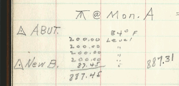
I have a field book where a crew set a new point in 1954 from an existing station. It was on flat level concrete, nothing in between. The book shows four 200.00' lengths, then 87.45, so total 887.45. It notes a temperature of 84å¡.
So, their corrected length as shown above is 887.31. I don't know what temperature their chain was standardized at, but if I assume 68å¡, I get a corrected distance of 887.36. Using their corrected distance means the tape was standardized at 60å¡ (working backwards). They most likely got the correction off of a chart.
Today, the area in between is totally overgrown, so it is not possible to shoot directly between them. Nor is it possible to occupy either one with GPS. So I located them both by setting pairs and traversing to them, in one case a direct tie and in the other a four station traverse. In both cases the pairs were not very open, and I used a VRS, so not the best ties.
I got a surface distance between them by inverse of 887.831 feet. I figured I could easily be off a few tenths considering how I tied them, so today I went to the other side of the river and observed to both using a 1" instrument, 1 mm å± 1 ppm instrument, corrected for T, P, and RH, etc. I computed a distance of 887.862 feet (side-angle-side triangle solution), so the VRS/traverse tie was not too bad, off 0.03 feet or 1 cm.
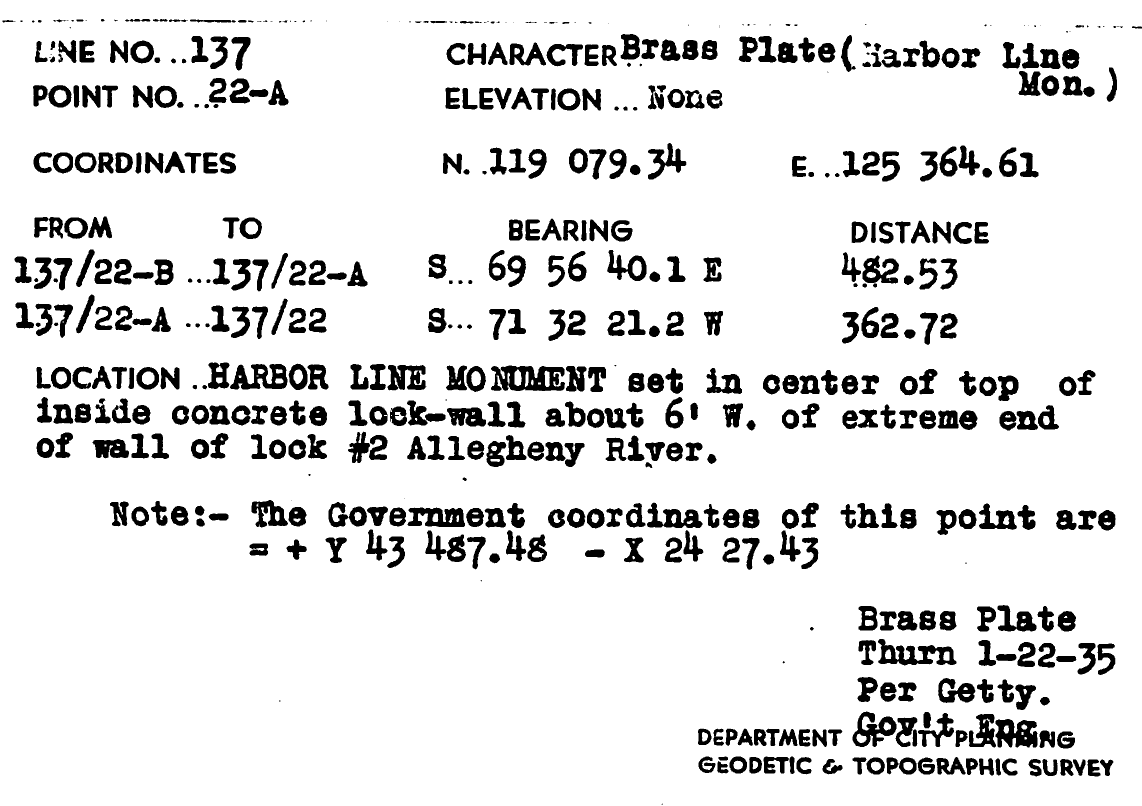
However, I am puzzled that it would be so much off of the taped distance from 1954, 0.55 feet, or 1/1615. The ends of the wall are unconstrained, so they could move. The wall was the land wall of a lock chamber, built in 1902. Here is the point at the west end, which is what they set in 1954.
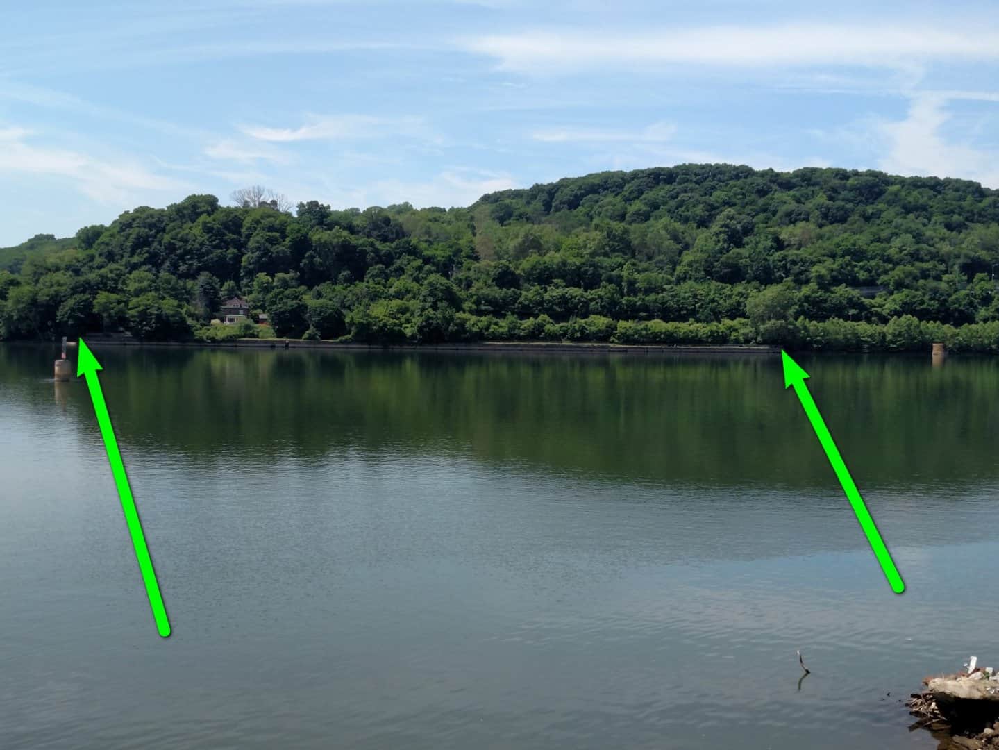
And here is the entire wall from where I shot from today:
I don't know whether to suspect that the wall has lengthened (possible, but that much?) or their chaining really sucked (also possible, but that much?)
This is sort of critical. These are harbor line monuments (originally set in 1895-1905 to define the harbor line system in this area, the 1954 work was to reset one of them that was destroyed). Most properties along the river go to the harbor line, even though it was officially abrogated in 1964. These are the only two surviving monuments for many miles.
Any opinions?
I should add that when I started in surveying in 1981 at the USACE, we only had two EDM and four crews, so we still did a LOT of chaining (200' steel tape), and I would like to think that we were pretty good, we pulled 20 lbs, used a thermometer, etc. Probably å±0.01'/tape length I would estimate when we were really trying.
Is that a joint line we see in the picture? If so how many joints are in the wall and are they uneven and show signs of settlement? You would think that they would have laid the tape flat on the concrete and would have had optimum conditions for accurate measurements. However when it had to be right, we would double chain to be sure. Although the temperature may have been 84, the temperature of the steel tape on a concrete surface may have been significantly higher. Were 200 foot steel tapes common in the area in 1954? The 100 foot standardize steel tapes that I have used were 100 feet at 100+ degrees.
Probably just a coincidence, but it jumped out at me that the .55 difference you mention added to the .45 of their raw measurement gives you an even foot. I haven't done enough real life taping to know if there's a goof that they could've made that would explain the coincidence.
I thought about it being hotter on the concrete, that would make the distance even shorter (tape expanded).
We do annual/biennial deformation surveys on 23 navigation locks, and we give results (differences from baseline surveys) as differences in a direction perpendicular to the axis of the wall. This is because the walls do expand and contract with temperature changes along that axis (which can be 1000's of feet long), so that value is almost meaningless. But, typical differences in the lengths of the walls are several centimeters, not as much as this. A typical wall in the modern locks is mostly built on pilings, except at the gate monoliths, where they are usually down to bedrock. So, the ends are unconstrained, but two areas in between are "fixed" (somewhat).
Because the old wall is overgrown, it was not possible to walk between to see if there are any obvious gaps. There are most likely joints every 20 to 30 feet.
Stephen Ward, post: 377411, member: 1206 wrote: Probably just a coincidence, but it jumped out at me that the .55 difference you mention added to the .45 of their raw measurement gives you an even foot. I haven't done enough real life taping to know if there's a goof that they could've made that would explain the coincidence.
I remember that there are "cut" tapes and "add" tapes. A typical 200' chain that I used was graduated every foot, and then either the last foot is graduated in hundredths or there is an extra foot on the end that is graduated in hundredths.
The earth moves around...things settle....expand...things change. Both measurements are probably close to correct at the time they were measured.
imaudigger...that may very well be the answer! Abandoned in 1934, little maintenance since then.
John Hamilton, post: 377413, member: 640 wrote: I remember that there are "cut" tapes and "add" tapes. A typical 200' chain that I used was graduated every foot, and then either the last foot is graduated in hundredths or there is an extra foot on the end that is graduated in hundredths.
I think you are on to something here.
Or maybe a simple boner.
Possibly inexperienced crew member.
One thing I just realized...the field notes say "New B is a lead plug with iron pin center, U.S. end of Old Land Wall Old Lock No.2"
That description makes no sense to me. It is definitely a lead plug, but it has a cross in it. The previous monument at that location was a brass harbor line plate, which were rectangular plates (sometimes triangular) attach with screws to the concrete. Since there is no sign of the plate or the screws, I believe that area was resurfaced sometime between 1902 and 1934. The other end has the plate removed, but the center and the four screws are plainly visible. They are not in the same place, about 0.8 feet apart.
Another interesting thing is that the missing plate is also part of the City of Pittsburgh control network (18,000 stations with data only existing on index cards), with a companion station (lead hub in between on the lock wall). A surveyor did a subdivision survey there in 1992, and used the city lead plug and the USACE lead plug as ties to city coordinates, even though they don't check between them (because the brass plate was replaced with a lead plug in a different location)
In my view of the world you have found the equivalent of perfection. You had the same two physical objects over 60 years apart in time and agree quite nicely, in my opinion. Nit picking can be a frustrating exercise. One can come up with 50 different arguments based on 50 different scenarios, none of which can be proven.
Celebrate!
You know I have heard the old timers say that when you are chaining that it is different when you are chaining between existing points or laying out a point.
It seems that if the chain was at 84å¡+ then it would be longer than it would be at 68å¡, therefore not being able to put as many chain lengths between the points, so that each 200Ûª length was actually longer than the 200Ûª recorded and the total distance would actually be longer than 887.45Ûª noted as the measured distance.
My first thought was a possible snafu with a 'cut' chain...
I would think that there MAY have ben some settlement in 60 + years.
I did a few lock dewatering surveys (24/7 until project ended) monitoring for the COE here. The lock walls were braced with heavy timber construction.
Maybe in 114 years, the timber could be moving, contracting or Somethin'
We would monitor measure every one hour around the clock by TS and chain. Always doubled chained and used a parasol on the TS. Had an air horn to get everyone out of the lock if there was detected movement
I want to say that you have settlement issues, SWAG but I'm not a structural engineer.
I agree with ekillo that the crew applied the correction in the wrong direction. BUT that doesn't make enough difference to explain the discrepancy. AND concrete has a coefficient of expansion too that will counter some of that.
I agree with ekillo that the crew applied the correction in the wrong direction. BUT that doesn't make enough difference to explain the discrepancy. AND concrete has a coefficient of expansion too that will counter some of that.
This discussion seems to be assuming the wall is a single static structure. It isn't. It's large pieces of concrete flying in close formation, even if it is anchored with piling.
While it appears to still enjoy its structural integrity, this may be due to the fact that it HAS expanded and contracted many times over the years. Every cold winter those cracks fill with more mineral fines and vegetation. And every hot summer the structure expands and pushes against itself. I have a tendency to believe that the 1954 measurement of the new, clean and pristine concrete was probably spot on, within their abilities.
Guessing the original survey was in error is just that, a guess. The monuments ARE probably a few tenths farther apart than they were back then. There's a lot of foreign material that has taken up residence in every crack along that 800'. I would be more worried if I measured LESS than they did in 1954.
paden cash, post: 377552, member: 20 wrote: This discussion seems to be assuming the wall is a single static structure. It isn't. It's large pieces of concrete flying in close formation, even if it is anchored with piling.
While it appears to still enjoy its structural integrity, this may be due to the fact that it HAS expanded and contracted many times over the years. Every cold winter those cracks fill with more mineral fines and vegetation. And every hot summer the structure expands and pushes against itself. I have a tendency to believe that the 1954 measurement of the new, clean and pristine concrete was probably spot on, within their abilities.
Guessing the original survey was in error is just that, a guess. The monuments ARE probably a few tenths farther apart than they were back then. There's a lot of foreign material that has taken up residence in every crack along that 800'. I would be more worried if I measured LESS than they did in 1954.
Whilst it is true that the cracks will generally fill up over a period of time, to increase the length of the wall by this means you are pushing quite a few thousand tons of structure along. As with most things (and people) the wall will take the easy way out and expand sidewards towards the water, which offers little restraint rather than along its length. (Think about long-welded rail where the length doesn't change significantly and the expansion occurs within the rail cross section). Settlement is unlikely to have changed the length by any noticeable amount unless either one end or the other has "rolled over".
Could it be a simple mis-booking or mis-hearing and the 87.45 should have been 87.95
Bill93, post: 377525, member: 87 wrote: I agree with ekillo that the crew applied the correction in the wrong direction. BUT that doesn't make enough difference to explain the discrepancy. AND concrete has a coefficient of expansion too that will counter some of that.
Bill, are you certain of this? Think about reinforced concrete; if concrete and steel (rebar) had substantially different coefficients of thermal expansion, construction as we know it would have a much shorter life expectancy.
Doesn't the chain get longer the hotter it gets? If so, I think the corrected the tape in the correct direction. Imagine a 100 foot tape that is so hot it it a foot longer. If measure a distance that is 100 feet long, the tape would show 99 feet. I also would have corrected the distance to 887.36'. My opinion, over that long a period of time, the distance has changed.


