Is there a way to edit the raw file so that it will recalculate a resection and the following side shots? I entered the wrong HR when preforming a resection, this caused my occupy point's elevation to be incorrect as well the following side shots' elevations to be incorrect. Is there a way I can fix this without having to go back and re-shoot these shots? Thanks in advance!
what platform/ software are you using?
Carlson SurvPC 3.02
Definitely wouldn't be going back.
Can't answer for SurveCE, but it'd be a fairly simple calculation (from your observations) to rework set up height, and adjust accordingly.
CKC, post: 327134, member: 9784 wrote: Is there a way to edit the raw file so that it will recalculate a resection and the following side shots? I entered the wrong HR when preforming a resection, this caused my occupy point's elevation to be incorrect as well the following side shots' elevations to be incorrect. Is there a way I can fix this without having to go back and re-shoot these shots? Thanks in advance!
Open the raw file with a text editor on windows or Mac; find the errant HR, and change it. Make sure to save the file back as an .rw5 or whatever (not a .txt).
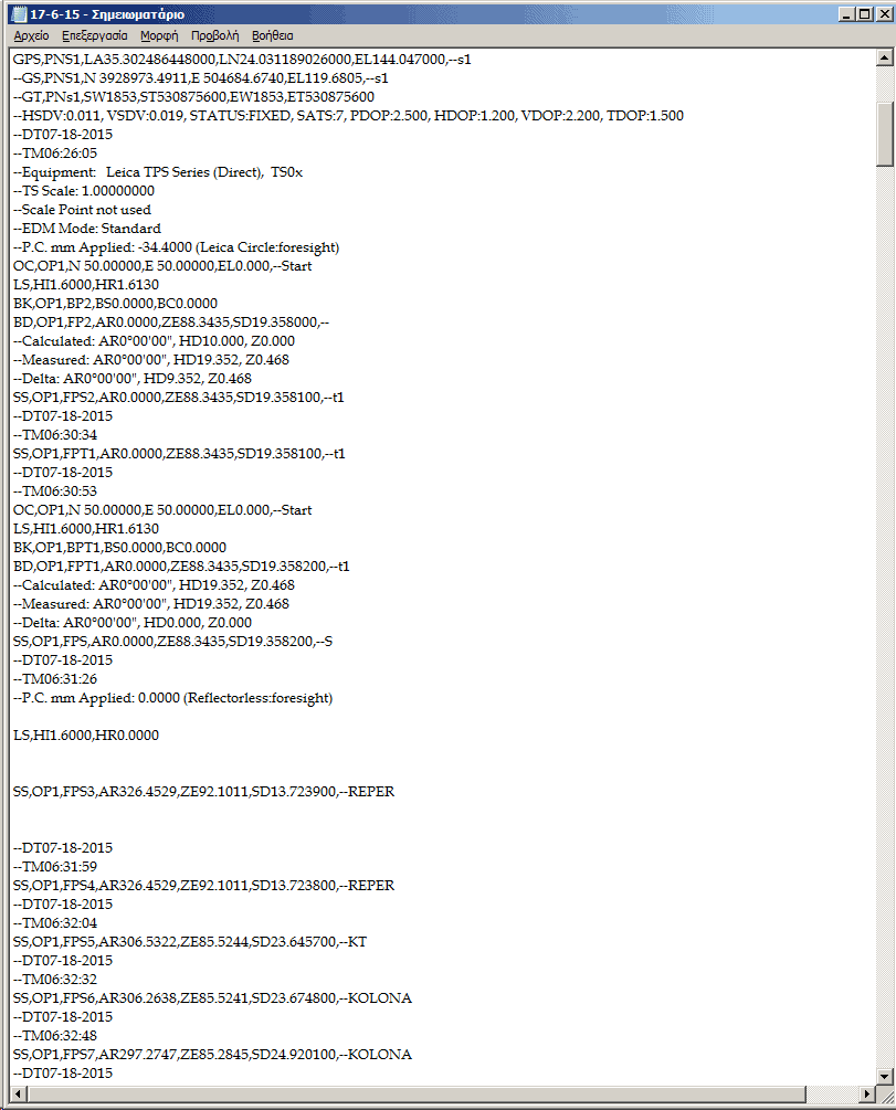
Can anyone tell me how i will take from rw5 file the same values as is in the rw5 file to a txt file?
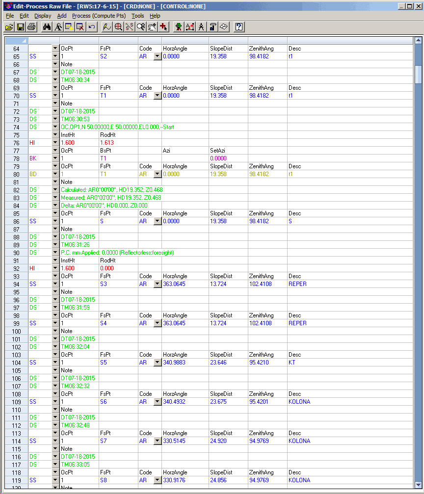
I open the rw5 file in carlson survey and compare it with open rw5 file as txt is not the same!
I have the original file here rw5 and i rename the rw5 file in order to take the same values in txt format why is not the same?
I want to insert the rw5 file in greek surveying program and i want to have the same values as i see it in survnet!
How i will do this?
Just edit the rw5 in Carlson Survey. Then process it.
Actually, since you have it back at the office, I'd just run it out in space, and then move/rotate it about your knowns.
I correct the raw file for the record. Since the error is elevation only it is a simple add/subtract to the appropriate elevations If you cannot do the math yourself and require software you probably should not be licensed.
Paul in PA
Just do the following open the raw file with survnet and compare with the same txt file you will see horizontial distances and azimouths different from txt Why this happens?
CKC, post: 327134, member: 9784 wrote: Is there a way to edit the raw file so that it will recalculate a resection and the following side shots? ...
Whether you can do that in the dc I do not know. But it is always possible to edit raw data back in the office and rerun it through various means. I prefer StarNet. When I am doing something like a resection I will do that, as a matter of routine, to check the results.
ëÔny advice for the post 9?
johnymal, post: 328078, member: 7096 wrote: Just do the following open the raw file with survnet and compare with the same txt file you will see horizontial distances and azimouths different from txt Why this happens?
My guess is that your software is formatting the raw data records so that they're more amenable to human eyes. The RW5 format, while hardly the most efficient in terms of disk space, was nevertheless designed as input to other software. Its records conform to a specification so that a computer can be programmed to interpret the data reliably, and little consideration was given to making it people-friendly. That said, the format isn't so cryptic that a human can't make sense of an RW5 file in an ASCII text editor, and those who routinely view and edit them get pretty good at reading the data in its original format.
"the format isn't so cryptic that a human can't make sense of an RW5 file in an ASCII text editor, and those who routinely view and edit them get pretty good at reading the data in its original format."
Do you know some program ëÀr routine to do this?
johnymal, post: 328110, member: 7096 wrote: Do you know some program ëÀr routine to do this?
Any ASCII text editor will open an RW5 file. Software to convert it to something more readable is another matter. I think Carlson XPort -- which seems to be bundled with SurvCE -- is one such application.
CKC, post: 327138, member: 9784 wrote: Carlson SurvPC 3.02
For editing a raw file in SurvCE/SurvPC:
- Under the File tab, click/tap button #4... Raw Data.
- Navigate to and find the desired Raw file, highlight it to select it and tap Green Check to open the file.
- Click the Edit/Export RW5 File button.
- Find the incorrect value(s) and highlight a value to select it and tap the Edit button.
- Make the necessary correction(s) and tap Green Check to open the file. NOTE: The original data is retained in the raw file and simply "commented" out from future processing.
- Make any other needed change(s) and tap the Orange Back button to save the change(s) to the raw file. NOTE: You can save the raw file to a different file name at this point, as needed.
- Tap the Process No Adjust button to recompute the coordinate. Set the desired processing values and tap Green Check to derive updated coordinates.
- Once completed, you can review the results. Upon hitting the Orange Back button and then tapping the Red X (Close) button, you'll be prompted if you want to save the new coordinates into the active coordinate file.
I hope this information helps.
johnymal, post: 328078, member: 7096 wrote: Just do the following open the raw file with survnet and compare with the same txt file you will see horizontial distances and azimouths different from txt Why this happens?
They appear to be the same to me.
You do not need to change the rw5 to txt. Just open the rw5 file with the notepad program.
From a quick scan of the data all I see is rounding and significant digits.
Look the line 94 and compare it with txt is not the same!
johnymal, post: 328204, member: 7096 wrote: Look the line 94 and compare it with txt is not the same!
In Carlson Survey under Settings -- Drawing Setup, see if Angle Mode is set to Gon.
363.0645 Gon equates to 326å¡45'29" and a Zenith Angle of 92å¡10'11" equates to 102.4108 Gon.


