

What do you think is the easiest way to get a precise water surface elevation of a still pond?
I would say putting the rod in the pond to the bottom after leveling from the bench mark. Then
you could read the intercept at the pond surface and subtract that from the intercept at the HI
getting an effective rod reading for the elevation at the surface.
?ÿ
Historic boundaries and conservation efforts.

Depending on finding a convenient location, just putting the rod at the water line on the shore is simpler and probably just as accurate.

I do this kind of thing all day, 5 days a week. I don't think there's a lot of precision involved. I do the best I can under varying conditions. The water could be still, slightly turbulent, whatever. I measure down from a nail in a boat dock, a disc on a headwall, an x-cut on a wingwall, etc. If necessary, I break out my level, tripod, bipod, and 25 ft. topo rod. You could drive a wood hub or stake flush with the surface of the water and take a rod shot on it. You could also step firmly on the ground as close to the water's edge as possible, take a rod shot there, and then subtract from your minus how much water is covering the rod. You know all this already, I'm sure.
You could drive a wood hub or stake flush with the surface of the water and take a rod shot on it.
To answer the original poster's question, this would be the easiest way to get a precise water surface elevation of a still pond.
Be sure to record the date, and possibly even the time.
Paul in PA

What do you think is the easiest way to get a precise water surface elevation of a still pond?
Be sure to specify the time and date of recording. The water level will vary from day to day. Which makes sweating out the precision moot.
Yes, I record the date of the observation. The time is an excellent suggestion.
I know a professor who had the task of observing the elevation of a pond for?ÿ
five years in order to get the mean. Wow! Talk about about taking advantage
of a situation.
Historic boundaries and conservation efforts.
For: Not my real name
Question:?ÿyou ask "get a precise water surface elevation"?ÿ ?ÿ just what do you call precise?
?ÿ
JOHN NOLTON
?ÿ
?ÿ
Well... as precise as you can get it. Think about the stake suggested by field dog or the method I planned to use.
As an example, if you measure something five times and the result is always the same then that is precise.?ÿ
Do you have a suggestion?
Historic boundaries and conservation efforts.

as precise as you can get it
Do you mean: only as precise as I want it to be?
you could always set up a tide gauge...
if you measure something five times and the result is always the same then that is precise.?ÿ
But is it accurate?
(Look at the upper right corner of the picture)
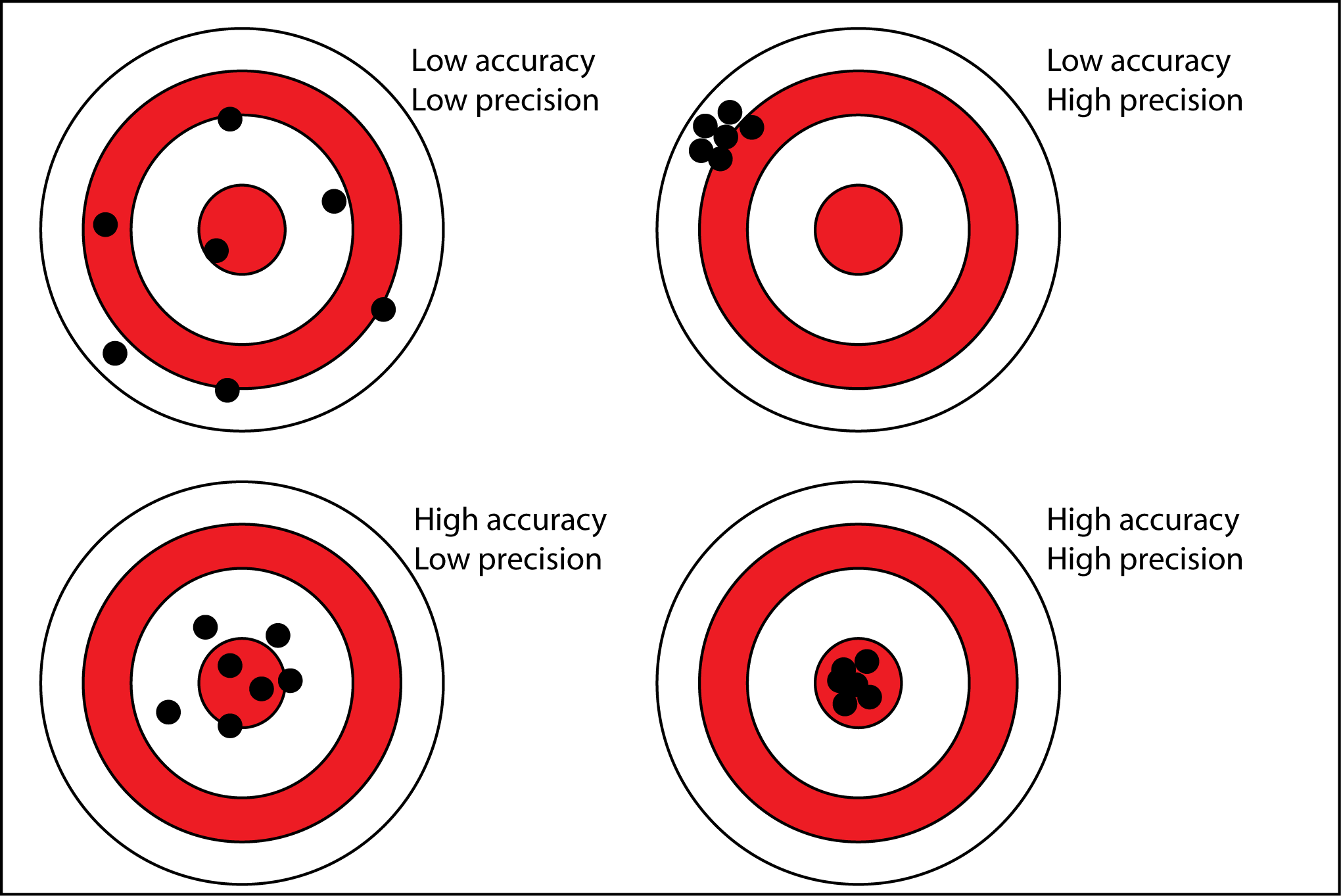
@dougie No I'm not looking for an accurate elevation. I want the most precise method. I gave an example of my professor's project using five years of data to compute a statistical mean. That is not the goal here. It is a still pond. Also, I am familiar with the definition of precise and accurate.
Historic boundaries and conservation efforts.

i use a stilling bucket?ÿ
i use a stilling bucket?ÿ
Ok, what is a stilling bucket?
@jules-j It would be a bucket with no bottom that would interrupt any surface motion inside while keeping the elevation the same. Pascal's principle.
Historic boundaries and conservation efforts.

COE lake managers will give you the water elevation of the day by simply calling them.
I like to go to the spillway and establish a reference to the water elevation and then apply that to the actual lake level. That can be carried all around the lake by the water level that day. It does help to check the reference at the end of day also and see if it has changed.
@jules-j It would be a bucket with no bottom that would interrupt any surface motion inside while keeping the elevation the same. Pascal's principle.
The OP said a "still pond" but since that may not be the case at the time you want to visit, the stilling pool is a good idea.?ÿ It's best if the bucket has a small hole so it takes longer to respond to a change in level than the time between waves.?ÿ Let it sit for a while to stabilize, i.e., take an average.

We do this all the time, there are many different types of ponds but they share some characteristics.
There is always a source, there is always a outflow point. The elevation of the outflow point determines the capacity of the pond and the maximum elevation, except when there is a major flood event which could raise the elevation above the spillway elevation.
Where the waterline is at any point in time isn't much of a consideration, ponds filled by an alluvial source can have a more stable elevation, but even those will rise and fall with the alluvial source, evaporation, rain fall, snow melt events.?ÿ
I suppose you can determine a mean elevation of some kind, that should be done with a gaging station installed. Those are on many reservoirs and I suppose natural lakes and ponds. I would consult an engineer that deals in safety of dams, they are the go to guys for this.?ÿ
We always determine the spill point, that is the elevation of the pond/reservoir that counts.
But then I'm not in the flatlands.?ÿ