
Interesting discussion.
Two weeks ago, we recovered a couple cast iron pipes with caps set in the 1820's on the Ohio-Erie Canal. (not my home county though)
We recovered 2 stones on a boundary survey a few months back that I was able to trace back to around 1865. (this one is in my home county)
And of course the Ohio River has been used as a boundary line with the Indian lands in this area since the mid 1700's.
Another surveyor here told me he recovered some original PLSS corners (stones and posts) in Gallia County, OH (county to the north of here) that dated back to the late 1700's.
That would be in Greene County. It is the next County to the west from where we are located. We do a few odd jobs in Greene County but not very mnay (maybe 1 or 2 a year).
In my home county, about 1870. That I have used: Gulf of Mexico and Long Island Sound (Connecticut side).
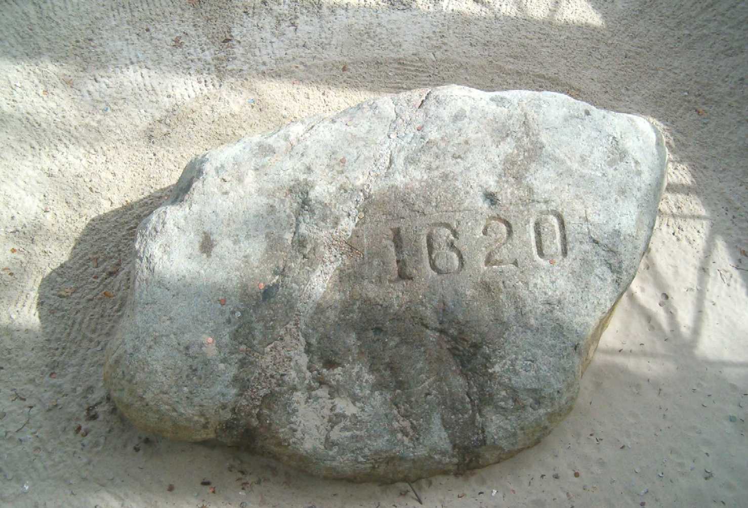
1600's*
Kinda of a tough question for me to answer.
I know the town line was monumented between Milford/Orange. Although I've never located a monument along the town line, I do believe one or two of them are around.
If so I'd say they in the late 1600's.
I think there some monuments in New Haven older than that though.
My Favorite Photo: Brad Foster's! Why?
Because some surveyor just HAD to tie flagging around it, in case the next guy had a hard time finding it.
Back in the mid-70s I was in NJ, working for a fellow that had acquired extensive records in Paterson, NJ. We were mapping some of the old mill buildings and raceways (canals) in the vicinity of the Great Falls. One of the buildings was the Colt Revolver mill.
The old point we tied into was an iron bar set in the stone at the top of the falls, one of the original control points established by Alexander Hamilton's work, circa 1792.
It is an interesting area. Water was diverted above the falls into the Upper Race, fed over water wheels into the Middle Race and then Lower Race, and finally exited out the Tail Race back into the river. Each drop produced an oportunity for powering a wheel.
The following was copied from the City of Paterson's history site:
The City of Paterson, located on the Passaic River in New Jersey was once one of the mightiest industrial cities of the United States. It has a rich history as the Nation's first planned industrial city, as well as containing some of the country's oldest textile mills and businesses.
In 1792, Alexander Hamilton formed an investment group called the Society of Useful Manufactures (the "SUM") whose funds would be used to develop a planned industrial city in the United States that was later to become Paterson. Hamilton believed that the United States needed to reduce its dependence on foreign goods and should instead develop its own industries.
The industries developed in Paterson were powered by the 77-foot high Great Falls of the Passaic, and a system of water raceways that harnessed the power of the falls. The district originally included dozens of mill buildings and other manufacturing structures associated with the textile industry and later, the firearms, silk, and railroad locomotive manufacturing industries. In the latter half of the 1800's, silk production became the dominant industry and formed the basis of Paterson's most prosperous period, earning it the nickname "Silk City." Paterson was also the site of historic labor unrest that focused on anti-child labor legislation, safety in the workplace, a minimum wage, and reasonable working hours.
KS
My Favorite Photo: Brad Foster's! Why?
LOL, SC.
It wasn't us....
🙂

1790ish
Actually marks the NWC of the county about a chain apart of course.
Jim Vianna


I need to do some research to figure out mine; I do remember finding a cedar post in northern Maine that was scribed in the 1850's.
But for now I'm going to guess that this:
is Foggy's Mon. 🙂
In my county (Solano)that would be Signal Hill PID JT1985. Originally set in 1880.
Some neats pics of this point on my portal page.
https://surveyorconnect.com/portal/galleries/hawkins-ls-7973/hawkins-land-surveying
I have also recovered the remains of Rancho Chimiles corner C5 about 1.2 miles to the Southwest in Napa county. The rancho was surveyed in the late 1860's.
Ty Hawkins LS7973
Hawkins Land Surveying
www.hawkinslandsurveying.com

The oldest monument I've seen in my home county is a cast iron 10-mile post on the Iowa-Missouri border set in 1850. It was set on a retracement of an 1816 survey that the Supreme Court held over other surveys. The retracement found quite a few marked trees, but mentioned only one stone, I don't think in this vicinity.
The main competitor to that line was run in 1836, and I haven't seen any mention of surviving monuments; probably only marked trees.
The next survey to pass through the county was a temporary treaty line in 1843 that I have done some research on and plotted on Google Earth. Again only post and mound and trees.
The GLO surveys in the county started about 1846 but I have the impression the stones were a later perpetuation.

My Favorite Photo: Brad Foster's! Why?
When my class found something, we ALL tied on some flagging, plus some "witness flagging" on everything nearby ... they tried to keep the spray paint away from us.

Is that on Kauai?
Like what we do here? Donate
Need a new or refreshed website? Five Point Web Solutions
Looking for a web host? Website Hosting & Management
Oldest I have dug up that no one really ever describes well enough to be sure they actually saw it since the day it was set: 1908. A nice square piece of granite with a copper tack.
There are a couple of stones that might be 1861-1867 but I would have to research them a lot more. Seems like around here GLO used cedar posts in gravel for most everything and they would get replaced with stones later.
Oldest in the county would be an interesting challenge. Some original GLO or DLC stone somewhere. Get back to ya in a few years!
1871 GLO stones. There are 1855-56 GLO surveys but posts were used and I have never seen one but have been to positions supposed to be perpetuations. The GLO didn't do any work in my county between 1857-70.
The oldest monument or survey in the county would be a town, Manti. It was settled and surveyed in 1849 six years before the GLO arrived. The town is there and a monument but I don't know if any original survey stakes markers still exist. The settler surveys were not accepted by the GLO but the areas were reserved for the settlers in aliquot parts. These areas were platted mostly in conformance to the original settler surveys within the aliquot parts revered for the town.