Reading RPLS is free for the whole profession. Members post, reply, and get the members-only rooms.

Notifications
Clear all

Topic starter
Translate
▼
English
Spanish
French
German
Italian
Portuguese
Russian
Chinese
Japanese
Korean
Arabic
Hindi
Dutch
Polish
Turkish
Vietnamese
Thai
Swedish
Danish
Finnish
Norwegian
Czech
Hungarian
Romanian
Greek
Hebrew
Indonesian
Malay
Ukrainian
Bulgarian
Croatian
Slovak
Slovenian
Serbian
Lithuanian
Latvian
Estonian
I have a deed for about 3 acres to the St. Thomas church that is an exception from the property of my client.
It was just down the "road" from a country school house that is described as a 1 ac. exception.
The church is long gone, the school house next to it is now under an impressive fill section of a major highway (state owned fee) that splits my clients property.
However, the highway doesn't quite touch the church deed and there is a fenced area that remains which doesn't follow the deed very well.
The remaining portion is occupied by an old cemetery which extends beyond the M&B description for the church and onto the clients deed. The best solution is to do a boundary line adjustment with the church, clean up the occupation vs. deed issues and protect the cemetery, but just who is the real owner? The only deed is 1911, no other transfers since; there isn't any evidence of a structure, all that was clean out decades ago.
I have a couple of theories about the existing owner, but I have to leave it up to the client for now as he doesn't wish to delve into it just yet, I was just curious if this is a common occurrence elsewhere.
Posted : December 29, 2016 8:29 am

Translate
▼
English
Spanish
French
German
Italian
Portuguese
Russian
Chinese
Japanese
Korean
Arabic
Hindi
Dutch
Polish
Turkish
Vietnamese
Thai
Swedish
Danish
Finnish
Norwegian
Czech
Hungarian
Romanian
Greek
Hebrew
Indonesian
Malay
Ukrainian
Bulgarian
Croatian
Slovak
Slovenian
Serbian
Lithuanian
Latvian
Estonian
We accept timberland conservation easements..one that of the ranches had a 5 acre exception for a school but it was non specific so I guess they knew where it was.
Posted : December 29, 2016 9:12 am

Translate
▼
English
Spanish
French
German
Italian
Portuguese
Russian
Chinese
Japanese
Korean
Arabic
Hindi
Dutch
Polish
Turkish
Vietnamese
Thai
Swedish
Danish
Finnish
Norwegian
Czech
Hungarian
Romanian
Greek
Hebrew
Indonesian
Malay
Ukrainian
Bulgarian
Croatian
Slovak
Slovenian
Serbian
Lithuanian
Latvian
Estonian
This cemetery had an 1890 deed (recorded in Book No. 1) from the gent that picked the qtr. section up in the land run of 1889 that called for "1 acre in the corner". The deed was to a church that was kitty corner to the cemetery and cease existing in WWII. No other conveyances had been made and since church property is exempt from tax rolls it just cruised right through the century with a record owner that really didn't exist. There had been a "cemetery association" which basically consisted of any member of two families that lived nearby and kept the place mowed but no formal conveyance.
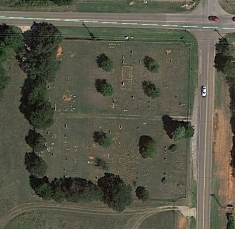
The surrounding area was purchased by a developer. We discovered in the course of surveying the "1 acre in the corner" was surrounded by a 100 year old rock wall with measurements of approximately 300' x 300'; definitely more than one acre. And there are "occupants" planted right up against the wall in some places.
Since "lot line adjustments" haven't really caught on in Oklahoma the developer merely quit claimed to the "association" a description we prepared that more appropriately described the boundary. Out of the "goodness" of his heart (yeah...right) the developer actually paid for the quiet title action that was necessary to get the property deeded to an entity that actually existed.
When discussing the fact that people were buried outside of the one acre boundary I remember the wise old surveyor I worked for at the time quipped, "humans at rest tend to stay at rest". 😉
Posted : December 29, 2016 9:59 am

Translate
▼
English
Spanish
French
German
Italian
Portuguese
Russian
Chinese
Japanese
Korean
Arabic
Hindi
Dutch
Polish
Turkish
Vietnamese
Thai
Swedish
Danish
Finnish
Norwegian
Czech
Hungarian
Romanian
Greek
Hebrew
Indonesian
Malay
Ukrainian
Bulgarian
Croatian
Slovak
Slovenian
Serbian
Lithuanian
Latvian
Estonian
Years ago I worked on a complicated Church/Cemetery survey.
The original deeds were from and at the adjacent corners of two separate parcels. Additional deeds were granted from one parcel to the Church/Cemetery over the years. After surveying it was found that all of the fenced in Church/Cemetery area was on one of the original parcels only. Those deeds were sufficient to encompass the premises. Church deeds come in many forms. The deed may be in the names of several elders, a formal or informal church Organization, and may never have been properly transferred as the Church changed denomination The original elders are very likely long gone, but the deed would not pass on to the elder's heirs, as the elders were merely signatories and holders for the Church. There well may be further grants to the Church/Cemetery that you are not aware of.
Cemeteries can present different problems. Burial grounds held by a Church may have been restricted to congregational members. At some time in the past the cemetery may have become a neighborhood entity and open to all. It well may have been covered by a separate Cemetery association, formal or informal, with a filed deed of transfer or not. I would not consider a boundary line agreement s appropriate especially because of he uncertainty of ownership. The cemetery is where it is despite your thoughts of the sanctity of some deed exception language and you need to survey around the actual exception. It is possible that with research you may find that the encroaching (as you think) graves are occupied by former adjacent landowners and not within the original deed.
These types of surveys can seldom be done within a normal fee, and since you are working for the Saints and the Almighty, that should be sufficient reward.
Paul in PA
Posted : December 29, 2016 10:12 am
Topic starter
Translate
▼
English
Spanish
French
German
Italian
Portuguese
Russian
Chinese
Japanese
Korean
Arabic
Hindi
Dutch
Polish
Turkish
Vietnamese
Thai
Swedish
Danish
Finnish
Norwegian
Czech
Hungarian
Romanian
Greek
Hebrew
Indonesian
Malay
Ukrainian
Bulgarian
Croatian
Slovak
Slovenian
Serbian
Lithuanian
Latvian
Estonian
After I finish this part of the boundary I may end up proceeding with a BLA.
There is a convent with lots of records going back to the 1800's. They were helpful before and if the church was Catholic (which I suspect) they may be the successors. That should make it "fairly" easy.
However, even though the area is unoccupied now there was at one time over 10,000 people living there, there is little remaining except cemeteries, a few structures, a handful of ranch houses and a small subdivision (6 homes) just north of this cemetery. I know there was more than one church in that community during it's heyday, so assuming this one was Catholic is just my guess.
Posted : December 29, 2016 10:57 am
Translate
▼
English
Spanish
French
German
Italian
Portuguese
Russian
Chinese
Japanese
Korean
Arabic
Hindi
Dutch
Polish
Turkish
Vietnamese
Thai
Swedish
Danish
Finnish
Norwegian
Czech
Hungarian
Romanian
Greek
Hebrew
Indonesian
Malay
Ukrainian
Bulgarian
Croatian
Slovak
Slovenian
Serbian
Lithuanian
Latvian
Estonian
Most Catholic Church properties are held in the name of the current Bishop. The original deed may be to Bishop A but Bishop D may be the one to transfer the property. I say most. The church I grew up in was a Missionary Church and is held by a specific Catholic Order. The Bishop still has certain Diocesan powers but does not assign the priests. The Order headquarters is in another state.
Contact the Diocesan Office to start.
Paul in PA
Posted : December 29, 2016 11:10 am

Translate
▼
English
Spanish
French
German
Italian
Portuguese
Russian
Chinese
Japanese
Korean
Arabic
Hindi
Dutch
Polish
Turkish
Vietnamese
Thai
Swedish
Danish
Finnish
Norwegian
Czech
Hungarian
Romanian
Greek
Hebrew
Indonesian
Malay
Ukrainian
Bulgarian
Croatian
Slovak
Slovenian
Serbian
Lithuanian
Latvian
Estonian
Paul in PA, post: 406447, member: 236 wrote: Cemeteries can present different problems.
We performed a boundary survey on a Cemetery described as the SW å? of the SE å? of Section etc. My developer client owned the SE å? less the SW å? and planned a development in the remainder. So the Cemetery received a ÛÏfreeÛ boundary survey in the process. To my absolute amazement everything we found fit "perfectly" ( within 0.4') on the whole survey. All sectional corners (8) and the center of section were monumented and certified with the State. The problem was that although the boundaries of the Cemetery were correct, a substantial amount of residents took up residence east of the East line thus residing on my clients land. Client figured the hell with it and deeded a 100 foot strip to the Cemetery so he could proceed and appease the necessary GodÛªs controlling the permitting process.
The East line of the new addition to the Cemetery has a very decorative 9Ûª concrete block wall guarding it. 😎
Posted : December 29, 2016 11:24 am

Translate
▼
English
Spanish
French
German
Italian
Portuguese
Russian
Chinese
Japanese
Korean
Arabic
Hindi
Dutch
Polish
Turkish
Vietnamese
Thai
Swedish
Danish
Finnish
Norwegian
Czech
Hungarian
Romanian
Greek
Hebrew
Indonesian
Malay
Ukrainian
Bulgarian
Croatian
Slovak
Slovenian
Serbian
Lithuanian
Latvian
Estonian
Worked with one cemetery association needing to expand. Discovered they had already encroached on four other owners. What a lovely mess that was.
Posted : December 29, 2016 6:54 pm

Translate
▼
English
Spanish
French
German
Italian
Portuguese
Russian
Chinese
Japanese
Korean
Arabic
Hindi
Dutch
Polish
Turkish
Vietnamese
Thai
Swedish
Danish
Finnish
Norwegian
Czech
Hungarian
Romanian
Greek
Hebrew
Indonesian
Malay
Ukrainian
Bulgarian
Croatian
Slovak
Slovenian
Serbian
Lithuanian
Latvian
Estonian
Many abandoned churches and school properties in Texas were set aside every so many miles apart to become community schools in rural areas.
Some lasted many years and reverted back to the state or county depending upon their locations and terms of their creation.
It is in our State Codes that surveyors must send in the location of any cemetery that has not been named or located before to the state.
I have found it amazing the dozens of cemeteries I've found all across Cass County from one family of 3 to several dozen marked by a simple stone pile or cut sandstone or crude formed concrete as what was placed atop many civil war graves.
Many were unkept for many years in very overgrown state and I simply stumbled upon them looking to see what the stone, wrought iron or wire fence was all about in the middle of nowhere.
Modern and well kept Cemeteries and Church grounds are my favorite place for GPS control points.
Posted : December 30, 2016 12:02 am