Reading RPLS is free for the whole profession. Members post, reply, and get the members-only rooms.

Notifications
Clear all
Strictly Surveying
25
Posts
11
Users
0
Reactions
987
Views

Topic starter
Translate
▼
English
Spanish
French
German
Italian
Portuguese
Russian
Chinese
Japanese
Korean
Arabic
Hindi
Dutch
Polish
Turkish
Vietnamese
Thai
Swedish
Danish
Finnish
Norwegian
Czech
Hungarian
Romanian
Greek
Hebrew
Indonesian
Malay
Ukrainian
Bulgarian
Croatian
Slovak
Slovenian
Serbian
Lithuanian
Latvian
Estonian
Scott Zelenak posted a problem not long ago asking "What latitude is half the distance from the equator to the pole"
I would like to give some information to this question and answer Bill93 question "How hard is the math to calculate
this without using those tools".
First you must know the ellipsoid to calculate the problem. This was NOT given; Bill93 used GRS80 and then Zelenak used
Clarke 1866 Ellipsoid.
Second you must know the quadrant distance, which of course is different for each ellipsoid. No one asked how to calculate this distance.
I gave the distance by calculating it in Mathematica V8.0 as I posted. Most people don't have this program so I will show how to get this
by other means (and not using NGS tools).
A very brilliant man from India, Srinivasa Ramanujan in 1914 gave a very simple approximate equation for the perimeter of an ellipse.
p~ pi(a+b)[1+3h/(10+sqrt(4-3h))]
here pi is of course 3.14159265358979...........
a= radius of major axis of ellipsoid
b= radius of minor axis of ellipsoid
h=(a-b)^2/(a+b)^2
sqrt= square root
Now to get maximum accuracy you must carry out all calculations to 15 or more places(pi, a, b,). Easy to find these numbers so I will not post them. See a paper by A. Weintrit "So, What is Actually the Distance from the Equator to the Pole?--Overview of the Meridian Distance
Approximations.
Oh I forgot to tell you to divide the perimeter by 4 for the quadrant( just incase somebody might say something).
OK now we have the quadrant distance and we divide it in half for Zelenak problem.
Now in the old days we had tables that were computed for the different ellipsoids. The Army used 5 ellipsoids , International,Bessel,
Everest, Clarke 1880 and the Clarke 1866. Tables were made and you could open the table to the page that came close to your distance.
They were calculated to every minute and also gave the difference per second. SO Bill93 it was very easy to find the Latitude given any distance
from the equator.
Now in modern times with NGS Geodetic Tools you can do as Bill93 did. Get the ellipsoid, do an inverse between zero Lat. and 90 degree Lat.
This gives the quadrant distance. Divide it in half for Zelenak problem. Then do a forward solution from zero Lat , azimuth zero, and the 1/2 quadrant distance an you have your answer. I do not know why Zelenak said he had an answer "after three iterations"
If one looks in most books on map projections you will find that they develop series for this type of problem.
NGS Special Pub. #241 Natural Tables for the Computation of Geodetic Positions, Clarke Spheroid 1866 has the following.
(here for the Clarke ellipsoid and Zelenak problem we want a distance of 5 000 944.02149+) The table only gives you distance to 0.001 m.
We see on page 46 for Lat. of 45d 08m a Meridional arcs(meters) of 4 999 544.727 and for 45d 09m 5 001 396.955 and a 1 second diff. of
30.870467 meters. By interpolation ones gets the answer of 45d 08m 45.3279
5000944.02149-4999544.727 (the table value) = 1399.29449
1399.29449/30.870467 (table value Diff. 1 sec) = 45.32793 seconds , add this to the entry value of 45d 08m and you get a Lat. of
45d 08m 45.32793 seconds which is the same in NGS Tools and the answer to the problem for Clarke 1866 ellipsoid.
JOHN NOLTON
Posted : February 24, 2016 6:46 pm
Topic starter
Translate
▼
English
Spanish
French
German
Italian
Portuguese
Russian
Chinese
Japanese
Korean
Arabic
Hindi
Dutch
Polish
Turkish
Vietnamese
Thai
Swedish
Danish
Finnish
Norwegian
Czech
Hungarian
Romanian
Greek
Hebrew
Indonesian
Malay
Ukrainian
Bulgarian
Croatian
Slovak
Slovenian
Serbian
Lithuanian
Latvian
Estonian
In my above post I forgot to include a formula by NGS for calculating the quadrant distance.
In USC&GS report of 1881, Appendix #12 there is an article "ON The Length of a Nautical Mile" by J.E. Hilgard
On page 355 NGS gives: Length of quadrant of the meridian;
1/4 pi (a+b) [ 1+1/4 (a-b/a+b)^2 + 1/64 (a-b/a+b)^4 + ...] very accurate.
JOHN NOLTON
Posted : February 24, 2016 7:16 pm

Translate
▼
English
Spanish
French
German
Italian
Portuguese
Russian
Chinese
Japanese
Korean
Arabic
Hindi
Dutch
Polish
Turkish
Vietnamese
Thai
Swedish
Danish
Finnish
Norwegian
Czech
Hungarian
Romanian
Greek
Hebrew
Indonesian
Malay
Ukrainian
Bulgarian
Croatian
Slovak
Slovenian
Serbian
Lithuanian
Latvian
Estonian
So, let me get this right. I need to take your calculations to Michigan DOT and have all these signs corrected to "Almost Half..."

Posted : February 24, 2016 8:31 pm

Translate
▼
English
Spanish
French
German
Italian
Portuguese
Russian
Chinese
Japanese
Korean
Arabic
Hindi
Dutch
Polish
Turkish
Vietnamese
Thai
Swedish
Danish
Finnish
Norwegian
Czech
Hungarian
Romanian
Greek
Hebrew
Indonesian
Malay
Ukrainian
Bulgarian
Croatian
Slovak
Slovenian
Serbian
Lithuanian
Latvian
Estonian
Ramanujan was a genius. He is compared to Euler and Jacobi often.
Posted : February 24, 2016 9:46 pm

Translate
▼
English
Spanish
French
German
Italian
Portuguese
Russian
Chinese
Japanese
Korean
Arabic
Hindi
Dutch
Polish
Turkish
Vietnamese
Thai
Swedish
Danish
Finnish
Norwegian
Czech
Hungarian
Romanian
Greek
Hebrew
Indonesian
Malay
Ukrainian
Bulgarian
Croatian
Slovak
Slovenian
Serbian
Lithuanian
Latvian
Estonian
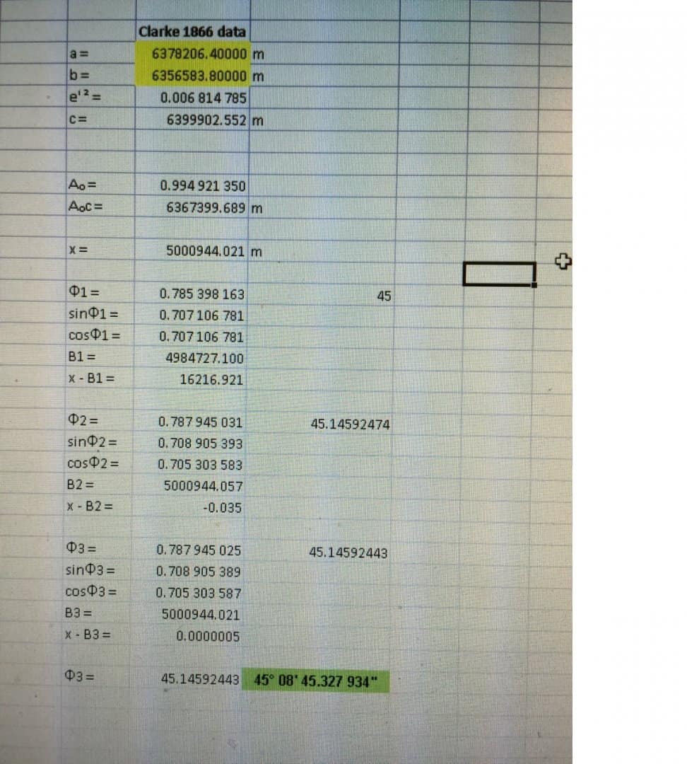
My data run through an iterative process.
I had 0.000 000 5 left over.
So call me a slacker for not doing another iteration.
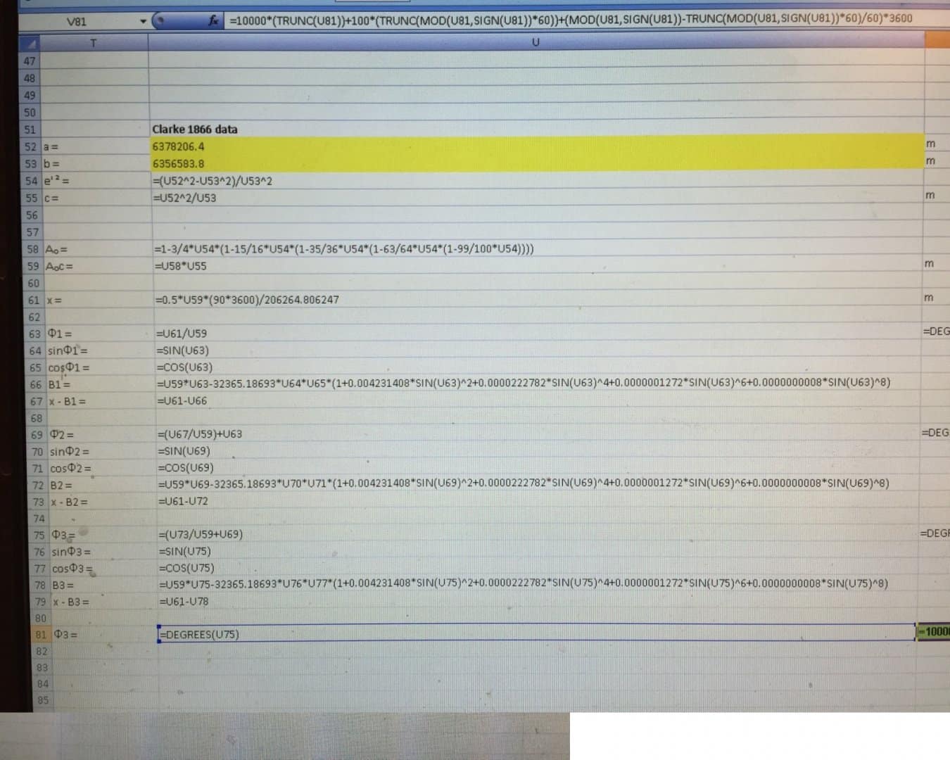
My formulae.
Posted : February 25, 2016 8:52 am

Translate
▼
English
Spanish
French
German
Italian
Portuguese
Russian
Chinese
Japanese
Korean
Arabic
Hindi
Dutch
Polish
Turkish
Vietnamese
Thai
Swedish
Danish
Finnish
Norwegian
Czech
Hungarian
Romanian
Greek
Hebrew
Indonesian
Malay
Ukrainian
Bulgarian
Croatian
Slovak
Slovenian
Serbian
Lithuanian
Latvian
Estonian
Then there is geocentric or geodetic? Is "way" a unit of distance? Half way = way/2?
Posted : February 25, 2016 8:52 am

Translate
▼
English
Spanish
French
German
Italian
Portuguese
Russian
Chinese
Japanese
Korean
Arabic
Hindi
Dutch
Polish
Turkish
Vietnamese
Thai
Swedish
Danish
Finnish
Norwegian
Czech
Hungarian
Romanian
Greek
Hebrew
Indonesian
Malay
Ukrainian
Bulgarian
Croatian
Slovak
Slovenian
Serbian
Lithuanian
Latvian
Estonian
Scott McLain, post: 359580, member: 6271 wrote: So, let me get this right. I need to take your calculations to Michigan DOT and have all these signs corrected to "Almost Half..."
"more or less". You always use "more or less". "å±" if you're low on room.
Posted : February 25, 2016 9:12 am

Translate
▼
English
Spanish
French
German
Italian
Portuguese
Russian
Chinese
Japanese
Korean
Arabic
Hindi
Dutch
Polish
Turkish
Vietnamese
Thai
Swedish
Danish
Finnish
Norwegian
Czech
Hungarian
Romanian
Greek
Hebrew
Indonesian
Malay
Ukrainian
Bulgarian
Croatian
Slovak
Slovenian
Serbian
Lithuanian
Latvian
Estonian
Scott McLain, post: 359580, member: 6271 wrote: So, let me get this right. I need to take your calculations to Michigan DOT and have all these signs corrected to "Almost Half..."
And Oregon. Possibly other states as well.
Posted : February 25, 2016 10:34 am

Translate
▼
English
Spanish
French
German
Italian
Portuguese
Russian
Chinese
Japanese
Korean
Arabic
Hindi
Dutch
Polish
Turkish
Vietnamese
Thai
Swedish
Danish
Finnish
Norwegian
Czech
Hungarian
Romanian
Greek
Hebrew
Indonesian
Malay
Ukrainian
Bulgarian
Croatian
Slovak
Slovenian
Serbian
Lithuanian
Latvian
Estonian
But that's all along the ellipsoid, what about the real globe..............
Posted : February 25, 2016 10:35 am
Topic starter
Translate
▼
English
Spanish
French
German
Italian
Portuguese
Russian
Chinese
Japanese
Korean
Arabic
Hindi
Dutch
Polish
Turkish
Vietnamese
Thai
Swedish
Danish
Finnish
Norwegian
Czech
Hungarian
Romanian
Greek
Hebrew
Indonesian
Malay
Ukrainian
Bulgarian
Croatian
Slovak
Slovenian
Serbian
Lithuanian
Latvian
Estonian
1st. No one has to go to any Dept. and say move your sign. Its close enough for City work/State work.
For Scott Zelenak: What you have done is take a 16 pound hammer and your computer to solve a very simple problem that can be solved using
a 2 ounce pencil and just a little brain power. In all the mapping books and other papers on Geodesy that I have read I do not see them saying that this problem is done by iteration; because its NOT the easy way. You did get the solution and that counts for something.
JOHN NOLTON
Posted : February 25, 2016 3:06 pm

Translate
▼
English
Spanish
French
German
Italian
Portuguese
Russian
Chinese
Japanese
Korean
Arabic
Hindi
Dutch
Polish
Turkish
Vietnamese
Thai
Swedish
Danish
Finnish
Norwegian
Czech
Hungarian
Romanian
Greek
Hebrew
Indonesian
Malay
Ukrainian
Bulgarian
Croatian
Slovak
Slovenian
Serbian
Lithuanian
Latvian
Estonian
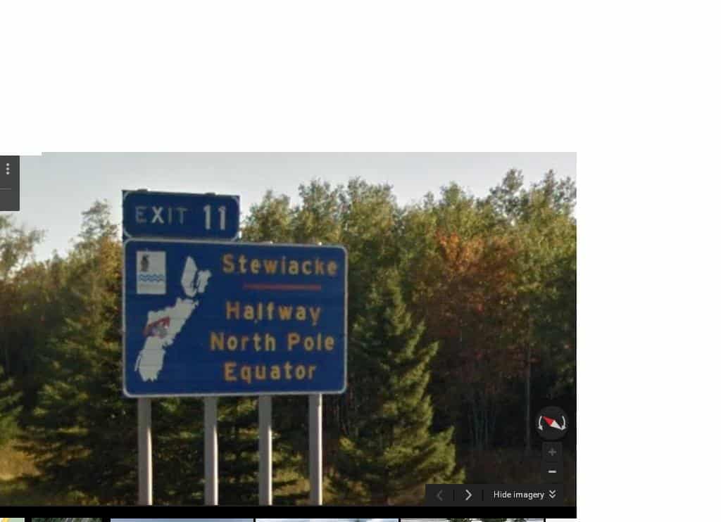
This one is less accurate...lol Nova Scotia style
Posted : February 25, 2016 5:24 pm
Translate
▼
English
Spanish
French
German
Italian
Portuguese
Russian
Chinese
Japanese
Korean
Arabic
Hindi
Dutch
Polish
Turkish
Vietnamese
Thai
Swedish
Danish
Finnish
Norwegian
Czech
Hungarian
Romanian
Greek
Hebrew
Indonesian
Malay
Ukrainian
Bulgarian
Croatian
Slovak
Slovenian
Serbian
Lithuanian
Latvian
Estonian
Well, John I used a variant of DeLambre's 217 year old formula for solving ellipsoidal distances.
We used to do it with the TI-55 calculator but it's slightly quicker with excel.
When I want to learn something I prefer the formulas to tables or software.
If I want the answer I'll use the software. If I want the knowledge I'll work it out.
So if a 217 year old formula is a sixteen pound hammer then, oh well, guilty as charged.
And sometimes the point isn't to get the correct answer to ten decimal places, it's to inspire critical and logical thought in the generation that has the unenviable misfortune to replace us.
Posted : February 25, 2016 6:18 pm
Translate
▼
English
Spanish
French
German
Italian
Portuguese
Russian
Chinese
Japanese
Korean
Arabic
Hindi
Dutch
Polish
Turkish
Vietnamese
Thai
Swedish
Danish
Finnish
Norwegian
Czech
Hungarian
Romanian
Greek
Hebrew
Indonesian
Malay
Ukrainian
Bulgarian
Croatian
Slovak
Slovenian
Serbian
Lithuanian
Latvian
Estonian
Wait now...isn't the earth flat?
Posted : February 25, 2016 9:03 pm

Translate
▼
English
Spanish
French
German
Italian
Portuguese
Russian
Chinese
Japanese
Korean
Arabic
Hindi
Dutch
Polish
Turkish
Vietnamese
Thai
Swedish
Danish
Finnish
Norwegian
Czech
Hungarian
Romanian
Greek
Hebrew
Indonesian
Malay
Ukrainian
Bulgarian
Croatian
Slovak
Slovenian
Serbian
Lithuanian
Latvian
Estonian
About 10 miles north of the 45th Parallel by my crude method. Used google earth to measure in miles from 0E, 0N to 0E, 45N east of Bourdeaux, France. This was 3097 miles. From 0E, 90N to 0E, 45 N measured 3117 miles. Difference of 20 miles. So it must be about 10 miles to the north to be equidistant. Give or take a few smoots.
Posted : February 25, 2016 9:27 pm
Translate
▼
English
Spanish
French
German
Italian
Portuguese
Russian
Chinese
Japanese
Korean
Arabic
Hindi
Dutch
Polish
Turkish
Vietnamese
Thai
Swedish
Danish
Finnish
Norwegian
Czech
Hungarian
Romanian
Greek
Hebrew
Indonesian
Malay
Ukrainian
Bulgarian
Croatian
Slovak
Slovenian
Serbian
Lithuanian
Latvian
Estonian
Mike Mac, post: 359789, member: 2901 wrote: Wait now...isn't the earth flat?
Clearly it isn't flat. I've driven over mountains that are definitely not flat! 😀
Posted : February 26, 2016 12:24 pm
Translate
▼
English
Spanish
French
German
Italian
Portuguese
Russian
Chinese
Japanese
Korean
Arabic
Hindi
Dutch
Polish
Turkish
Vietnamese
Thai
Swedish
Danish
Finnish
Norwegian
Czech
Hungarian
Romanian
Greek
Hebrew
Indonesian
Malay
Ukrainian
Bulgarian
Croatian
Slovak
Slovenian
Serbian
Lithuanian
Latvian
Estonian
Where is halfway equator to pole?
In reality it's a fair and good question. Either as a bar bet, or a genuine test question. As we can see there are a lot of qualifiers, technical considerations, and math. There is the casual answer, and ultimate resolution. I read a really good account of the answer to that very question: French Academy of Science, circa 1792. Pierre M̩chain and Jean-Baptiste Delambre tried to do just that by measuring a portion of a meridian. And they learned just how hard that is to do. And it took seven years and several additional campaigns; nearer the pole, across the equator, as well as across France. Even Mason/Dixon's Delaware - Maryland border survey data was included.
And as we all (should) know, the meter was conceptualized as a cardinal fraction of the distance from the equator to the pole. And that was hard then, and relevant today.
So calculate it, estimate it, qualify it. It's as fun as it is educational. Bring on the hammers, 64 bit software, slide rule, or 8th grade text book.
And when you have an answer, the next question: is that true for astronomic? Geographic, geodetic, or geodesic? Can you you get there with GPS? or do you need a Zenith sector? did you account for deflection of the prime vertical? Geodesics are complicated and we get with murder these days with our software and GPS receivers. Try retracing latitudes and meridians of the western states boundaries. GPS or astronomic?
And what if the question was to monument the mid point of the California Utah border? That's real world.
There is plenty of technical questions. Well worth the thought experiment. Just ask Johann Gauss.
Good book on the subject: The Messure of All Things, by Ken Alder. A must read to appreciate GPS and classical methods.
Posted : February 26, 2016 1:51 pm
Translate
▼
English
Spanish
French
German
Italian
Portuguese
Russian
Chinese
Japanese
Korean
Arabic
Hindi
Dutch
Polish
Turkish
Vietnamese
Thai
Swedish
Danish
Finnish
Norwegian
Czech
Hungarian
Romanian
Greek
Hebrew
Indonesian
Malay
Ukrainian
Bulgarian
Croatian
Slovak
Slovenian
Serbian
Lithuanian
Latvian
Estonian
:gammon: I meant Utah Nevada border.
Posted : February 26, 2016 2:14 pm

Translate
▼
English
Spanish
French
German
Italian
Portuguese
Russian
Chinese
Japanese
Korean
Arabic
Hindi
Dutch
Polish
Turkish
Vietnamese
Thai
Swedish
Danish
Finnish
Norwegian
Czech
Hungarian
Romanian
Greek
Hebrew
Indonesian
Malay
Ukrainian
Bulgarian
Croatian
Slovak
Slovenian
Serbian
Lithuanian
Latvian
Estonian
Larry Scott, post: 359894, member: 8766 wrote: And what if the question was to monument the mid point of the California Utah border? That's real world.
Hmmm...That would be the [very] OLD border (pre 1861).
B-)
Loyal
Posted : February 26, 2016 2:16 pm
Translate
▼
English
Spanish
French
German
Italian
Portuguese
Russian
Chinese
Japanese
Korean
Arabic
Hindi
Dutch
Polish
Turkish
Vietnamese
Thai
Swedish
Danish
Finnish
Norwegian
Czech
Hungarian
Romanian
Greek
Hebrew
Indonesian
Malay
Ukrainian
Bulgarian
Croatian
Slovak
Slovenian
Serbian
Lithuanian
Latvian
Estonian
Larry Scott, post: 359896, member: 8766 wrote: :gammon: I meant Utah Nevada border.
Which one?
1861?
1862?
1866?
Theoretical ("deed")?
As surveyed and monumented?
Grid or Ground?
Sign me up, sounds like a blast!
🙂
Loyal
Posted : February 26, 2016 2:19 pm
Translate
▼
English
Spanish
French
German
Italian
Portuguese
Russian
Chinese
Japanese
Korean
Arabic
Hindi
Dutch
Polish
Turkish
Vietnamese
Thai
Swedish
Danish
Finnish
Norwegian
Czech
Hungarian
Romanian
Greek
Hebrew
Indonesian
Malay
Ukrainian
Bulgarian
Croatian
Slovak
Slovenian
Serbian
Lithuanian
Latvian
Estonian
So, if the POB of an existing parcel was the mid point of the Nevada Utah border? Would that be by latitude? Distance? Slope chaining?
Could you defend a different distance for the north and south halves? if by latitude?
Could you walk to it with RTK?
Posted : February 26, 2016 2:35 pm
Page 1 / 2
Next