Bushwhacker, post: 356667, member: 10727 wrote: I think I would sub-divide the Section using the Re-Survey plat, then hold the East to West 1/4 Section line and the South line of the Section, then use the acreage from the Original plat for the 2 lots in question to determine how for to slide the East line of the lots.
That is one of my two options, the issue with doing that is then the E2SW4 becomes 79 acres. For the rest of the township they made sure the patented/homestead areas got their full acreage, it's just this one that was "shorted".
The question is do you hold the original as you say and I think is a very good argument or do you go with the resurvey plat and protect it and the 545 acre Section 6. You can look at these two lots as not being a part of section 6 since they exclude the acreage for them.
I do know they went to landowners in the townships and got them to agree to these surveys. I also know that some landowners rejected the surveys.
I think the standard method of section subdivision for section 6 still applies here. Since the patent was issued from the original survey, that is where the parentheticals should be derived. Sliding lines to protect acreage would disregard the method of section subdivision stated in the manual. The patent did not warrant the patentee would get exactly the acreage stated. That's why they say 'more or less'.
You may want to look real close at the manual on Lotted Sections. The method that I stated was what Mr. John Beasley of the U.S.F.S. and I can to for a situation near Waldon, Arkansas where the B.L.M. produced a new Township plat but did not set any of the interior corners. The bases for this method is to protect the original patent which has senior rights to the resurvey.
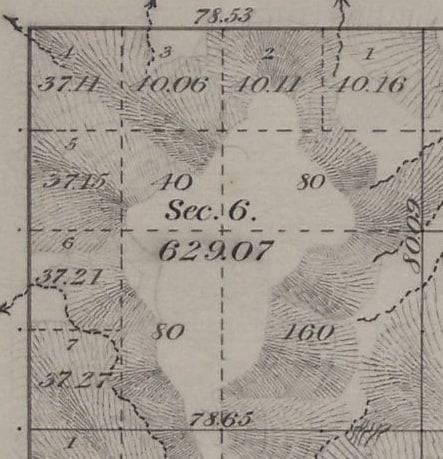
MightyMoe, post: 356511, member: 700 wrote: Section 6 is part of an 1884 original survey.
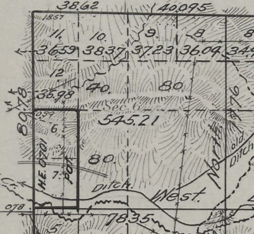
The entire township was independently resurveyed in 1915.
Only the township lines are based on original corners.
the question would be where to place the NE and SE corners of Lots 6 and 7.
The independent resurvey is very accurate, all caps with the exception of the S1/4 of 6 have been recovered and there are errors of less than 2 links in the lines.
Should Lots 6 and 7 be prorated using the independent resurvey plat.
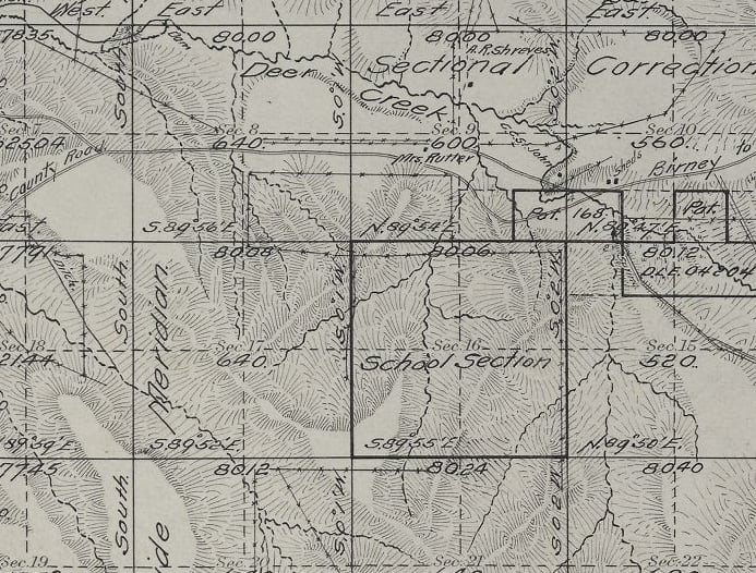
the east line of the new Section 6 is a "Sectional Guide Meridian" the south line is a "Sectional Correction Line"
Original Plat:
Independent Resurvey Plat:
Moat HES were surveyed with full sets of notes and monuments anD their own plat. See if you can find those first
Jerry
jlwahl, post: 356702, member: 68 wrote: Moat HES were surveyed with full sets of notes and monuments anD their own plat. See if you can find those first
Jerry
This was not a HES.
It was a HE
I just wish they would have tracted it instead of letting it sit there.
MightyMoe, post: 356703, member: 700 wrote: I just wish they would have tracted it instead of letting it sit there.
[MEDIA=youtube]RV-p51fvYLc[/MEDIA]
What is the location for this township? I would like to look at the entire plat just for curiosity. You can email me direct if you'd rather not publically post it here.
Bushwhacker, post: 356695, member: 10727 wrote: You may want to look real close at the manual on Lotted Sections. The method that I stated was what Mr. John Beasley of the U.S.F.S. and I can to for a situation near Waldon, Arkansas where the B.L.M. produced a new Township plat but did not set any of the interior corners. The bases for this method is to protect the original patent which has senior rights to the resurvey.
I have been reading up on it, of course the language is more confusing than helpful sometimes.
I think the answer is there and it's to conform to the new independent resurvey.
J. Penry, post: 356715, member: 321 wrote: What is the location for this township? I would like to look at the entire plat just for curiosity. You can email me direct if you'd rather not publically post it here.
sure, what is your email, I couldn't seem to track it down
MM,
By looking at the IR plat, the GLO obviously (?) believed the N, S, & E lines of Lots 6 & 7 from the original plat are being protected by the IR plat & the only explanation would be they felt the south and east boundaries of Section 6 were a dependent resurvey (best available evidence or proportion) of the original survey. Or maybe this just slipped by "regular procedure" ..................
Is there any federal interest land adjoining the Lots 6 & 7, or anywhere that may be affected by what you do?
If so (and probably even if not), I would recommend checking with the state BLM office and get their input, maybe they have more information on what really happened and why.
Obviously, what is causing you pause is fact that the owners of the E1/2SW1/4 & the lots N & S of Lots 6 & 7 will be interested in your solution. The more I think about this, the more I would be inclined to follow the IR plat, unless there is better evidence of the original survey lying out there waiting to found of the original survey for the E & S boundaries of Section 6. But really, even if there is, and assuming other lands in Section 6 were patented under the IR plat, can you then move their lines?
Apparently, you have a couple of choices: 1) protect lots 6 & 7 (based solely on "proportioning" from corners established by the IR - which are apparently not original positions from the original plat - so are you really re-establishing the original lines?) and possibly infringe upon the lots/aliquots adjoining them or 2) protect the adjoining lots/aliquots and infringe on Lots 6 & 7.
Brian Allen, post: 356724, member: 1333 wrote: MM,
By looking at the IR plat, the GLO obviously (?) believed the N, S, & E lines of Lots 6 & 7 from the original plat are being protected by the IR plat & the only explanation would be they felt the south and east boundaries of Section 6 were a dependent resurvey (best available evidence or proportion) of the original survey. Or maybe this just slipped by "regular procedure" ..................
Is there any federal interest land adjoining the Lots 6 & 7, or anywhere that may be affected by what you do?
If so (and probably even if not), I would recommend checking with the state BLM office and get their input, maybe they have more information on what really happened and why.Obviously, what is causing you pause is fact that the owners of the E1/2SW1/4 & the lots N & S of Lots 6 & 7 will be interested in your solution. The more I think about this, the more I would be inclined to follow the IR plat, unless there is better evidence of the original survey lying out there waiting to found of the original survey for the E & S boundaries of Section 6. But really, even if there is, and assuming other lands in Section 6 were patented under the IR plat, can you then move their lines?
Apparently, you have a couple of choices: 1) protect lots 6 & 7 (based solely on "proportioning" from corners established by the IR - which are apparently not original positions from the original plat - so are you really re-establishing the original lines?) and possibly infringe upon the lots/aliquots adjoining them or 2) protect the adjoining lots/aliquots and infringe on Lots 6 & 7.
The east section line is a Sectional Guide Meridian, and the south section line is A Sectional Correction Line, basically the east and south lines of Section 6 of the IR have nothing to do with the original lines. The original survey gets cancelled after the Independent Resurvey, and I suppose that really is the answer. You can't actually go backwards.
They just created those two lines across the township, intersected the township lines as cc's, then built the independent resurvey section lines off them creating 640 ac sections. There are new lots along all the township lines now.
MightyMoe, post: 356723, member: 700 wrote: sure, what is your email, I couldn't seem to track it down
jpenry at lancaster dot ne dot gov
MightyMoe, post: 356730, member: 700 wrote: The east section line is a Sectional Guide Meridian, and the south section line is A Sectional Correction Line, basically the east and south lines of Section 6 of the IR have nothing to do with the original lines. The original survey gets cancelled after the Independent Resurvey, and I suppose that really is the answer. You can't actually go backwards.
They just created those two lines across the township, intersected the township lines as cc's, then built the independent resurvey section lines off them creating 640 ac sections. There are new lots along all the township lines now.
Mighty:
Made many a trip on that old County Road in my younger days when I lived between Birney and Ashland about 5 miles South of the road up O'Dell Creek. I will send you a diagram of what I would do on the E-W center line.
Charles L. Dowdell, post: 356787, member: 82 wrote: Mighty:
Made many a trip on that old County Road in my younger days when I lived between Birney and Ashland about 5 miles South of the road up O'Dell Creek. I will send you a diagram of what I would do on the E-W center line.
Thanks Charles:
That's really in the boondocks-between Birney and Ashland, ever go to a country dance at the old Sayle Hall?
MightyMoe, post: 356792, member: 700 wrote: Thanks Charles:
That's really in the boondocks-between Birney and Ashland, ever go to a country dance at the old Sayle Hall?
No, never got to Sayle for any dances. Maybe went over there when I was a toddler but don't remember it. Did get to Birney once for a dance when I worked the summer of 1952 for the guy that bought my Dad's old place when he sold out in 41 when I started to school. There were a lot of good lookin' gals that came out of the hills to that dance. I used to get to a lot of the dances at Decker though in the early to mid 50's.
One critical element in following the original Government surveys is determining how truthful the fiction writers were as they assembled the field notes.
Today, I was going through the two sets of field notes required for my subject section. The very first work done was the establishment of an Indian Boundary Line running east to west with milestones set about 25 years before the first of the two projects to create sections. The tribes north of the line had come from forested areas of Wisconsin, New York and some other States in that corner of the US. The tribe to the south had moved from Illinois to Missouri and finally here starting about 1800. The tribes to the north gave up first and told the Great White Father in D.C. what he could do with that non-forested land.
That survey to establish sections worked south from a standard parallel and ended on the IBL. The northeast corner of the subject section was set, then the crew headed on south to find the 38th Mile Stone. By golly they missed it by 20 links and were east of the stone. So they moved over to the stone and headed back to the section corner. Precisely 15.65 chains. A couple days later they came from the north and set the northwest corner of the subject section. Then they headed east towards the northeast corner set earlier. Son of a gun, it is precisely 80.00 chains distant and they hit it dead on. Per standard procedure they returned to the northwest corner and headed south towards the 39th Mile Stone. By golly they missed it by 20 links and were east of the stone. So they moved over to the stone and headed back to the section corner. Precisely 15.65 chains. What an amazing coinkydink!?!? Oh, and to make it even more incredible, they reported that they set rather large stones at every section corner.
Six or seven years later the tribe south of the IBL headed further west before ending up in what is now Oklahoma. That survey to lay out sections sounded more believable. Most of the closing lines varied off of the perfect 80.00 chains and normally they would miss the aimed-for corner by some number of links. All of those corners were stake and pits variety. A survey in the section to the west of the subject section underwent a full section breakdown just a few years later. The county surveyor found nearly all of the stake and pits corners somewhat intact and set stones to replace the stakes. He couldn't find any of the stones supposedly set by the first sectional survey. But, he did find the Mile Stones.
Mighty,
This is a case where I would definitely want the Special Instructions for the Independent Resurvey. There is no doubt a reason why they did what they did (and didn't do in the way of tracting). The Land Entry Case File for the Homestead Entry Patent might also come in handy at some point (you don't really know what's in it, till you get it).
If there are still Imperial Entanglements adjoining Lots 5 & 6, then you really should run everything past the BLM before painting yourself into a corner.
Just my 2 bits,
Loyal
Loyal, post: 356809, member: 228 wrote: Mighty,
This is a case where I would definitely want the Special Instructions for the Independent Resurvey. There is no doubt a reason why they did what they did (and didn't do in the way of tracting). The Land Entry Case File for the Homestead Entry Patent might also come in handy at some point (you don't really know what's in it, till you get it).
If there are still Imperial Entanglements adjoining Lots 5 & 6, then you really should run everything past the BLM before painting yourself into a corner.
Just my 2 bits,
Loyal
Yes Imperial Entanglements (isn't there always).
The answer is to use the Independent Resurvey plat, not really a choice here.
I'm a bit gun shy cause there were local folks who rejected some Independent Resurveys and the Imperial Establishment has told me that is perfectly fine, they don't have to accept them.
Anywho that isn't the case here, the landowner signed off and accepted so,,,,,,,,,,,,,,,,
MM, I just noticed the 0.78 at the southwest corner of section 6. Do you suppose that could be some area of the homestead in section 7, formerly section 6.
vern, post: 357273, member: 3436 wrote: MM, I just noticed the 0.78 at the southwest corner of section 6. Do you suppose that could be some area of the homestead in section 7, formerly section 6.
That's the offset between the section corner common to 1 & 12, and the one for 6 & 7. They are both still there as are both 1/4's on the west line


