We probably all use google, and we probably have all decided what our comfort level using it is.
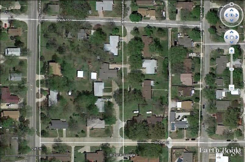
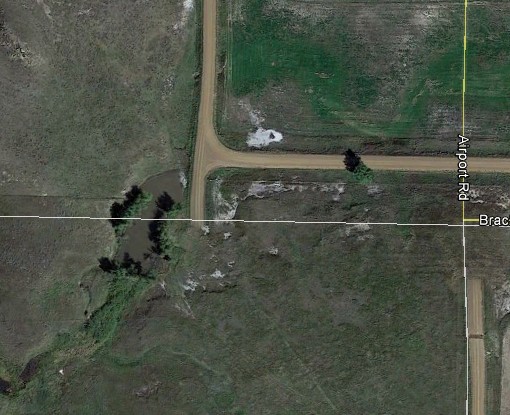
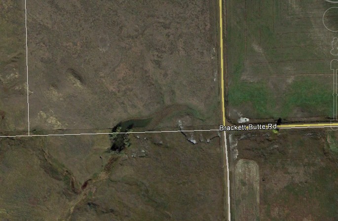
I'm always getting asked how accurate it is, and it's been difficult to say, some spots it seems within a couple of feet, others are not so good, here is one of those and something else to consider and that's the t factor that google has available.
Google photo 2014:
Same location Google photo 2013:
Just be careful out thereB-)
We use Georeferenced photographs provided by our State and we found this error in the 2010 photograph, so its not just Google.

Find the words: W 2nd St just to the right of center near the bottom. Look a bit to the northwest to discover a house and a half a house with the same car and fence to the north of them. Then look to the northwest of that to find Tennessee Ave. being ripped at a 45 just before it would slam into a house. The rest of Tennessee Ave. is a bit to the northeast of that.
It's a nice tool, makes a nice picture, but .............
As of January 29th it won't matter because the parcel lines won't be available any longer.
Google understands it is not necessary to reinvent the wheel so they actually use PA geo-referenced photos in some areas of PA. I have found most PA and NJ area photos to be within 0.5' which is suitable for all my purposes.
I just Googled my home address and found the aerial to be a recent PAMAP image. My street view is 2 1/2 years old. Several years ago I was in front of my house when the Google car came up the side street. I never checked to see if I was on it then, but I am not on the current side street view for the intersection.
Paul in PA
Holy Cow, post: 354865, member: 50 wrote: Then look to the northwest of that to find Tennessee Ave. being ripped at a 45 just before it would slam into a house.
And the two nearly identical small white sheds 50'+/- WNW of there. Double wow!
gschrock, post: 354879, member: 556 wrote:
For a local site you can see if there are any aerial pre-marks, or good high contrast ground-level features with well-defined corners to shoot (e.g. concrete vaults, stop bars, etc) and go out and observe those then see how well they fit.
Or...if you're working in some flavor of NAD83, just export your drawing as a .kml file and see how it looks. Usually I'll match well defined ground features, like storm drain structures, within a foot or two.
Paul in PA, post: 354876, member: 236 wrote: ..I just Googled my home address and found the aerial to be a recent PAMAP image.
Is the stack of traffic cones still at the corner of your house by the garage door? 😉
Yeah, I find errors like this often when Google has "stitched together" imagery from two different sources. It is most apparent when it happens in a rural area and a continuous road appears to dead end in a field and then continue on from a completely different point. The lat/long of the roadways is usually pretty good. But the imagery doesn't always fit those roads due to all kinds of reasons.
The errors I've found on GE are usually 1 out of 10 times I want to zoom in on a tract, the area I really need to look at will not come into focus.
There will be a thousand acre spot that will stay out of focus.
The other day I could not see an area because it was "obscured by clouds" that were at the ground level.
With all its glitches and errors, still one of my favorite tools that keeps me from driving all over the county to get a recent view of the world and be able to converse with a client over the phone and be able to get an understanding about where something should be and to plan new boundaries and quote an area that is very close and be able to answer many questions quickly with a free program.
Are the photos wrong? Are the streets wrong? What is right? and what is wrong?
paden cash, post: 354884, member: 20 wrote: Is the stack of traffic cones still at the corner of your house by the garage door? 😉
The small ones are back in the Jeep, the large ones are currently frozen to the ground. They are generally only out when I need the rear seat of the Jeep, such as this year over Christmas. I was set up for a pickup and return of our niece to Philly Airport, However the weather was nice and we took the car. Other times it is when we take BIL and SIL along eagle watching along the upper Delaware in February or grandchildren to PA Farm Show.
The PA photos are orthorectified, so photo to photo fit is quite good. Most helpful when I have to fit 4 - 2 mile by 2 mile photos for a project that is in the corner.
Paul in PA
Mike Falk, post: 354916, member: 442 wrote: Are the photos wrong? Are the streets wrong? What is right? and what is wrong?
It depends on what the definition of wrong is...
Paul in PA, post: 354876, member: 236 wrote: Google understands it is not necessary to reinvent the wheel so they actually use PA geo-referenced photos in some areas of PA. I have found most PA and NJ area photos to be within 0.5' which is suitable for all my purposes.
I just Googled my home address and found the aerial to be a recent PAMAP image. My street view is 2 1/2 years old. Several years ago I was in front of my house when the Google car came up the side street. I never checked to see if I was on it then, but I am not on the current side street view for the intersection.
Paul in PA
.5' would be nice, as you can see from the photos above, neither the 2013 or 2014 match at all.
I don't see anywhere that kind of accuracy using google.
Of course over the years I have gained access to "real" photos in many situations which are very accurate, some of those cover large areas and are often from sources not available to the public.
And sometimes they have found their way into the google database, it's interesting to see them when they pop up.
Mike Falk, post: 354916, member: 442 wrote: Are the photos wrong? Are the streets wrong? What is right? and what is wrong?
Well, in my experience, the locations of the streets in the database (not the imagery) is the closest to being "right". In other words, if you get a lat/long for one of the roads they are showing and then drive there with a handheld GPS unit, you'll likely be right on the point. But if you get a lat/long from a feature in their imagery, it may be close, but it may be WAY off.
skwyd, post: 354980, member: 6874 wrote: Well, in my experience, the locations of the streets in the database (not the imagery) is the closest to being "right". In other words, if you get a lat/long for one of the roads they are showing and then drive there with a handheld GPS unit, you'll likely be right on the point. But if you get a lat/long from a feature in their imagery, it may be close, but it may be WAY off.
Hand held and driving GPS units have a "snap to the road" feature so you never know how far off you are.
vern, post: 355028, member: 3436 wrote: Hand held and driving GPS units have a "snap to the road" feature so you never know how far off you are.
Yes, but on some units you can shut them off. And I've had pretty good luck with that. Usually 50' +/- as opposed to some image features being 200' or more off.
At the scale of map your looking at, what width is the road vs. the symbol for the road?


