Reading RPLS is free for the whole profession. Members post, reply, and get the members-only rooms.

Notifications
Clear all
Strictly Surveying
19
Posts
8
Users
0
Reactions
720
Views

Topic starter
Translate
▼
English
Spanish
French
German
Italian
Portuguese
Russian
Chinese
Japanese
Korean
Arabic
Hindi
Dutch
Polish
Turkish
Vietnamese
Thai
Swedish
Danish
Finnish
Norwegian
Czech
Hungarian
Romanian
Greek
Hebrew
Indonesian
Malay
Ukrainian
Bulgarian
Croatian
Slovak
Slovenian
Serbian
Lithuanian
Latvian
Estonian
Hello,
A friend asked me if I could plot a parcel of land based on the given description in the land title just to get an idea of the shape. While this should be easy, I don't come close to a closed result or an area matching the 13 Hectare area as described.
Some bearings are not clear, but I tried all combinations with no success (see photo). I was wondering if I could get another set of eyes to help interpret this?


Posted : September 22, 2017 6:20 am

Translate
▼
English
Spanish
French
German
Italian
Portuguese
Russian
Chinese
Japanese
Korean
Arabic
Hindi
Dutch
Polish
Turkish
Vietnamese
Thai
Swedish
Danish
Finnish
Norwegian
Czech
Hungarian
Romanian
Greek
Hebrew
Indonesian
Malay
Ukrainian
Bulgarian
Croatian
Slovak
Slovenian
Serbian
Lithuanian
Latvian
Estonian
Given the apparent lack of accuracy in the typing, as indicated by strikeovers and obvious uncorrected mistakes, it would not be surprising to find more than one numerical error. That makes it very difficult to have confidence in a reconstruction.
I tried some variations. I was encouraged to find that the closure was very near 100 meters, but the closure bearing is too differend from any side for that to explain it. If you assume two mistakes and change 215.19 to 115.19 and 564.11 to 554.11 the closure is 0.84 m, still too large, and I think the area is too small (not calculated carefully).
Another attempt is to change the 16-13 bearing to 6-13. That gives a closure of 1.6 m, which is too much, and the area may still be too big (not calculated carefully).
I think someone needs to acquire a copy of the plan G-21364, which may have a clearer depiction.
Posted : September 22, 2017 9:21 am
Topic starter
Translate
▼
English
Spanish
French
German
Italian
Portuguese
Russian
Chinese
Japanese
Korean
Arabic
Hindi
Dutch
Polish
Turkish
Vietnamese
Thai
Swedish
Danish
Finnish
Norwegian
Czech
Hungarian
Romanian
Greek
Hebrew
Indonesian
Malay
Ukrainian
Bulgarian
Croatian
Slovak
Slovenian
Serbian
Lithuanian
Latvian
Estonian
0.84m is better than 100m haha, but of course that's an assumption. I was looking around for some Philippine websites to see if there was any public parcel data like we often have US/Canada, but no luck.
I appreciate your efforts. Thanks
Posted : September 22, 2017 9:43 am

Translate
▼
English
Spanish
French
German
Italian
Portuguese
Russian
Chinese
Japanese
Korean
Arabic
Hindi
Dutch
Polish
Turkish
Vietnamese
Thai
Swedish
Danish
Finnish
Norwegian
Czech
Hungarian
Romanian
Greek
Hebrew
Indonesian
Malay
Ukrainian
Bulgarian
Croatian
Slovak
Slovenian
Serbian
Lithuanian
Latvian
Estonian
The good thing is that there is a reference to where the drawing can be found and hopefully they got that part correct.
Posted : September 22, 2017 12:34 pm

Translate
▼
English
Spanish
French
German
Italian
Portuguese
Russian
Chinese
Japanese
Korean
Arabic
Hindi
Dutch
Polish
Turkish
Vietnamese
Thai
Swedish
Danish
Finnish
Norwegian
Czech
Hungarian
Romanian
Greek
Hebrew
Indonesian
Malay
Ukrainian
Bulgarian
Croatian
Slovak
Slovenian
Serbian
Lithuanian
Latvian
Estonian
I believe the deed is clear in that it does not include the closing course...........
Paul in PA
Posted : September 22, 2017 12:59 pm

Translate
▼
English
Spanish
French
German
Italian
Portuguese
Russian
Chinese
Japanese
Korean
Arabic
Hindi
Dutch
Polish
Turkish
Vietnamese
Thai
Swedish
Danish
Finnish
Norwegian
Czech
Hungarian
Romanian
Greek
Hebrew
Indonesian
Malay
Ukrainian
Bulgarian
Croatian
Slovak
Slovenian
Serbian
Lithuanian
Latvian
Estonian
Paul in PA, post: 447877, member: 236 wrote: I believe the deed is clear in that it does not include the closing course...........
Paul in PA
Starts at 1 ends at 1, so it says.
Posted : September 22, 2017 2:09 pm

Translate
▼
English
Spanish
French
German
Italian
Portuguese
Russian
Chinese
Japanese
Korean
Arabic
Hindi
Dutch
Polish
Turkish
Vietnamese
Thai
Swedish
Danish
Finnish
Norwegian
Czech
Hungarian
Romanian
Greek
Hebrew
Indonesian
Malay
Ukrainian
Bulgarian
Croatian
Slovak
Slovenian
Serbian
Lithuanian
Latvian
Estonian
It sucks but, try and hit all the surrounding deeds and see what is left in the middle
Posted : September 22, 2017 2:28 pm
Translate
▼
English
Spanish
French
German
Italian
Portuguese
Russian
Chinese
Japanese
Korean
Arabic
Hindi
Dutch
Polish
Turkish
Vietnamese
Thai
Swedish
Danish
Finnish
Norwegian
Czech
Hungarian
Romanian
Greek
Hebrew
Indonesian
Malay
Ukrainian
Bulgarian
Croatian
Slovak
Slovenian
Serbian
Lithuanian
Latvian
Estonian
Doug Crawford, post: 447889, member: 9 wrote: Starts at 1 ends at 1, so it says.
Starts at 1,
goes on to N61-15E 107.44 m. to point 7,
N36-34E to point ?...... (probably 8)
...... m. to point 1
The course from 8 to 1 is missing, and it says along a stream, so the meanders may not be too precise.
Paul in PA
Posted : September 22, 2017 6:18 pm
Translate
▼
English
Spanish
French
German
Italian
Portuguese
Russian
Chinese
Japanese
Korean
Arabic
Hindi
Dutch
Polish
Turkish
Vietnamese
Thai
Swedish
Danish
Finnish
Norwegian
Czech
Hungarian
Romanian
Greek
Hebrew
Indonesian
Malay
Ukrainian
Bulgarian
Croatian
Slovak
Slovenian
Serbian
Lithuanian
Latvian
Estonian
Paul in PA, post: 447912, member: 236 wrote: The course from 8 to 1 is missing,
I don't think so for two reasons.
-It lists the type of monument for 7 points.
-If you assume the values given are 7-8 and allow whatever it takes to close from 8 to 1, the area is far too big.
Posted : September 22, 2017 6:36 pm

Translate
▼
English
Spanish
French
German
Italian
Portuguese
Russian
Chinese
Japanese
Korean
Arabic
Hindi
Dutch
Polish
Turkish
Vietnamese
Thai
Swedish
Danish
Finnish
Norwegian
Czech
Hungarian
Romanian
Greek
Hebrew
Indonesian
Malay
Ukrainian
Bulgarian
Croatian
Slovak
Slovenian
Serbian
Lithuanian
Latvian
Estonian
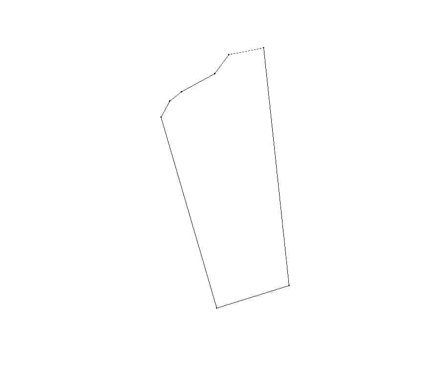
I think Paul is right, the last course is missing. Looks like it follows the creek to point 7 and then probably leaves the creek and follows a straight line back to point 1, which according to my interpretation of the bearings would yield a forced distance of 99.97 meters.
Barangay Agdao lists a current population of around 800 and GE doesn't show the barangay hall. I would say N15.891141 by E120.323606 is pretty close. The creek is plainly visible, going to see if I can plot it.
Here is my best guess.
Posted : September 22, 2017 7:21 pm
Translate
▼
English
Spanish
French
German
Italian
Portuguese
Russian
Chinese
Japanese
Korean
Arabic
Hindi
Dutch
Polish
Turkish
Vietnamese
Thai
Swedish
Danish
Finnish
Norwegian
Czech
Hungarian
Romanian
Greek
Hebrew
Indonesian
Malay
Ukrainian
Bulgarian
Croatian
Slovak
Slovenian
Serbian
Lithuanian
Latvian
Estonian
My plot above yields 17+ hectares, obviously a lot bigger than the deed....
Posted : September 22, 2017 7:26 pm

Translate
▼
English
Spanish
French
German
Italian
Portuguese
Russian
Chinese
Japanese
Korean
Arabic
Hindi
Dutch
Polish
Turkish
Vietnamese
Thai
Swedish
Danish
Finnish
Norwegian
Czech
Hungarian
Romanian
Greek
Hebrew
Indonesian
Malay
Ukrainian
Bulgarian
Croatian
Slovak
Slovenian
Serbian
Lithuanian
Latvian
Estonian
Paul in PA, post: 447912, member: 236 wrote: Starts at 1,
goes on to N61-15E 107.44 m. to point 7,
N36-34E to point ?...... (probably 8)
...... m. to point 1The course from 8 to 1 is missing, and it says along a stream, so the meanders may not be too precise.
Paul in PA
Look again. the carryover on second page is just transcription garbage carried over from first page, on first page deed makes a closing call from point 7 N 36-34 E 66.74 m to point 1, there is no point 8 the deed summery on page 2 confirms that. Plan G-21364 needs to be investigated as well as the ground monuments and improvements to find the bust. Some issues simply cant be solved from a chair.
Posted : September 22, 2017 7:41 pm
Translate
▼
English
Spanish
French
German
Italian
Portuguese
Russian
Chinese
Japanese
Korean
Arabic
Hindi
Dutch
Polish
Turkish
Vietnamese
Thai
Swedish
Danish
Finnish
Norwegian
Czech
Hungarian
Romanian
Greek
Hebrew
Indonesian
Malay
Ukrainian
Bulgarian
Croatian
Slovak
Slovenian
Serbian
Lithuanian
Latvian
Estonian
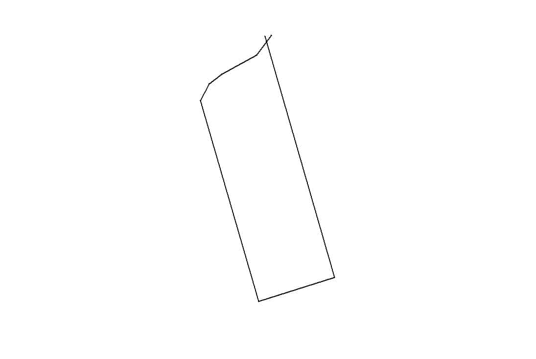
Apparently there are 2 Barangays Agdao about 8 miles apart near Malasiqui. The one I mentioned above is the wrong one. The correct WGS lat/long is N15.918384, E120.457172.
I now think all of the calls are there. Possibly the first line is S 16-10 E which almost parallels the west line of N 16-13 W. This would plot at 1:95 yielding 13.3 Hectares. Only the recorded plan will clear it up.
Posted : September 22, 2017 9:15 pm
Translate
▼
English
Spanish
French
German
Italian
Portuguese
Russian
Chinese
Japanese
Korean
Arabic
Hindi
Dutch
Polish
Turkish
Vietnamese
Thai
Swedish
Danish
Finnish
Norwegian
Czech
Hungarian
Romanian
Greek
Hebrew
Indonesian
Malay
Ukrainian
Bulgarian
Croatian
Slovak
Slovenian
Serbian
Lithuanian
Latvian
Estonian
A better closure and area result from keeping the bearing on line 1-2 and changing line 3-4 to be N 6-13 W. It still isn't good enough.
Posted : September 23, 2017 8:37 am
Translate
▼
English
Spanish
French
German
Italian
Portuguese
Russian
Chinese
Japanese
Korean
Arabic
Hindi
Dutch
Polish
Turkish
Vietnamese
Thai
Swedish
Danish
Finnish
Norwegian
Czech
Hungarian
Romanian
Greek
Hebrew
Indonesian
Malay
Ukrainian
Bulgarian
Croatian
Slovak
Slovenian
Serbian
Lithuanian
Latvian
Estonian
Kevin Davis, post: 447934, member: 6918 wrote: The correct WGS lat/long is N15.918384, E120.457172.
Can you find any lines near there that look like the sketch? None of the features seem to align near the right bearings.
Posted : September 23, 2017 9:08 am
Translate
▼
English
Spanish
French
German
Italian
Portuguese
Russian
Chinese
Japanese
Korean
Arabic
Hindi
Dutch
Polish
Turkish
Vietnamese
Thai
Swedish
Danish
Finnish
Norwegian
Czech
Hungarian
Romanian
Greek
Hebrew
Indonesian
Malay
Ukrainian
Bulgarian
Croatian
Slovak
Slovenian
Serbian
Lithuanian
Latvian
Estonian
Bill93, post: 447974, member: 87 wrote: Can you find any lines near there that look like the sketch? None of the features seem to align near the right bearings.
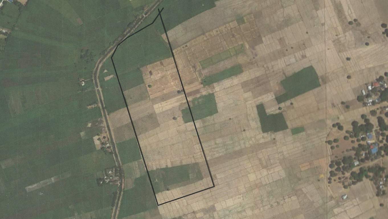
This would be my best guess. My wife is from Luzon to the northeast over in the Cagayan River valley. Very similar situation with the rice fields in the river bottoms. When I was there I looked for markers dividing the fields just to see how they do it. I didn't see many permanent markers, mostly sticks. I would image its hard to keep the divisions between the fields to conform with the property lines. Probably easier with rice than corn. In the areas where corn is grown that I saw, every square inch is plowed and planted 2 sometimes 3 times a year.
I looked for a place where the creek ran NE and the general pattern of the fields looks more like SE/NW at around16 instead of 6 for the east and west line bearings. SW cor approx. N15.9306?ø, E120.4630?ø. Could also shift it about 83 meters to the northeast to get a rough fit. The creek appears to have been straightened since 1923/1933.
Posted : September 23, 2017 3:07 pm
Translate
▼
English
Spanish
French
German
Italian
Portuguese
Russian
Chinese
Japanese
Korean
Arabic
Hindi
Dutch
Polish
Turkish
Vietnamese
Thai
Swedish
Danish
Finnish
Norwegian
Czech
Hungarian
Romanian
Greek
Hebrew
Indonesian
Malay
Ukrainian
Bulgarian
Croatian
Slovak
Slovenian
Serbian
Lithuanian
Latvian
Estonian
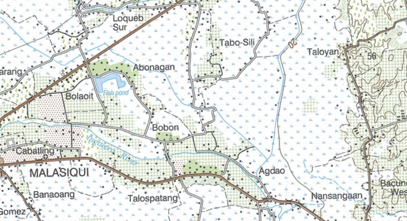
Here is a topo map of the area with the barangay of Taloyan just to the east of where this property might be. The map doesn't ID the watercourse as "Toloyan Creek" but it seems the most likely place for it, running up northerly from Agdao.
Posted : September 23, 2017 3:14 pm
Translate
▼
English
Spanish
French
German
Italian
Portuguese
Russian
Chinese
Japanese
Korean
Arabic
Hindi
Dutch
Polish
Turkish
Vietnamese
Thai
Swedish
Danish
Finnish
Norwegian
Czech
Hungarian
Romanian
Greek
Hebrew
Indonesian
Malay
Ukrainian
Bulgarian
Croatian
Slovak
Slovenian
Serbian
Lithuanian
Latvian
Estonian
It might help if some of our members from the Philippines, have any input
Posted : September 24, 2017 7:32 pm
Topic starter
Translate
▼
English
Spanish
French
German
Italian
Portuguese
Russian
Chinese
Japanese
Korean
Arabic
Hindi
Dutch
Polish
Turkish
Vietnamese
Thai
Swedish
Danish
Finnish
Norwegian
Czech
Hungarian
Romanian
Greek
Hebrew
Indonesian
Malay
Ukrainian
Bulgarian
Croatian
Slovak
Slovenian
Serbian
Lithuanian
Latvian
Estonian
Thanks for all the input. I came up with the same idea as Kevin, finding the Toloyan creek on a satellite image and looking for similar shape to the northerly part of the lot. I also thought the S16 10E looked like a better bearing giving an area that matches closer to the description.
This is all I wanted to accomplish with this exercise, to be able to show my friend a visual shape of the land, but when I was 100m out, I thought I'd get some opinions.
This is my first time using the forum. I appreciate all the comments and help. Thanks.
Posted : September 25, 2017 8:33 am