Not sure I've ever seen one quite like it:
it starts at the center of Section 17 which is a section about 2500 feet N-S and 5280 E-W.
The only way to make sense of it is to use the N1/4 as the Center1/4.
describing a tract in the W2SE4
Commencing at the center of Section 17
Then it says to go south 700' to a rimrock, thence south to the top of the rimrock, closest to the bridge (bridge is about 1/3 of a mile away), thence NE along rimrock to river, thence along river to a point below the mouth of an intersecting stream, thence along rimrock to POB.
The bridge call makes no sense, the acreage call of 20 acres is widely off, the rimrock calls are very confusing, but if you put it all together there may be as much as 60 acres in the deed instead of 20acres.
What I surmise happened is that the deed writer took the 1903 plat and used the topo shown on it for the description. The 1903 plat shows the river in the W2SE4 when it's in the E2SE4 or SE4SE4 and Lot 1. If you use the plat the 20 acres does kinda look correct. The owners have a report by a surveyor in 1974 that says the deed is impossible to survey, and he goes through the reasons why he believes so.......
I can't disagree with him too much, it really is awful.......
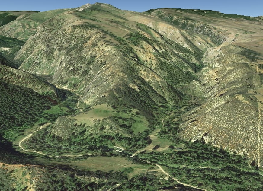
country looks like this:
It does look possible, use two of the three rimrocks and the river and there you have it, a bounded legal with lots of assumptions. There sure aren't any people left from 1921 to chat about it.
What is the legal definition of rimrock? I would not know where to begin.
[hl]COLLATERAL EVIDENCE[/hl] (Topography) and [hl]EVIDENCE ALIUNDE [/hl](Aliunde means from another place or outside source. It is often used to refer to evidence given aliunde when meaning cannot be derived from a document or instrument itself. For example, when a will contains an ambiguity, in some cases, in order to ascertain the meaning of the testator, evidence aliunde will be received.)
DDSM:beer:
lmbrls, post: 364778, member: 6823 wrote: What is the legal definition of rimrock? I would not know where to begin.
don't think you will find a legal definition
MightyMoe, post: 364786, member: 700 wrote: don't think you will find a legal definition
Oh c'mon,..for a few thousand dollars Walt Robillard will present a seminar on "the proper location of rimrock calls"...
You've got yourself a doosie there...the 1974 surveyor might have had the best opinion on the subject.
paden cash, post: 364796, member: 20 wrote: Oh c'mon,..for a few thousand dollars Walt Robillard will present a seminar on "the proper location of rimrock calls"...
You've got yourself a doosie there...the 1974 surveyor might have had the best opinion on the subject.
It's possible he did, the nice thing is that the present day neighbor owns the entire ranch that this deed was created from and the ranch deed EXCEPTS out this deed, at least I don't have THAT to deal with:-)
The County GIS tried to put it on paper, then they came up with 170 acres (lot 3-35ac, Lot 4-35ac, S2SW4-80ac. and this deed-20ac).
The plot on the GIS has everyone confused, looks to me like they either have 190 acres or 210 acres (depending on which south rimrock is used) the county went between the two south rims and entirely missed the creek call............so if you use the middle rimrock for the south line the county is showing lands entirely outside the parcel.
If you plot the thing on the old GLO plat it does make about 20acres which must be where the deed came from,,,,,,,,
A paper survey the 700 feet is nonsense. Who would use a GLO topo to actually write a description?
MightyMoe, post: 364915, member: 700 wrote: ... Who would use a GLO topo to actually write a description?
I've seen it. Not too often, but always a possibility. I mean, that's ALL they had at one point in time.
No topo calls, but here's one that took a little bit to figure out:
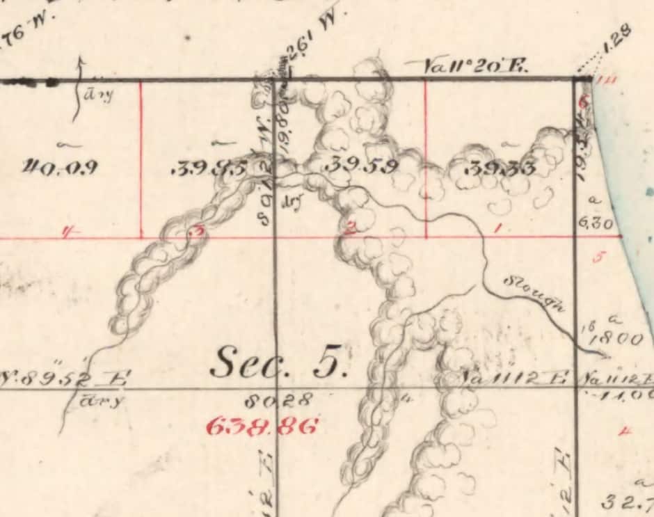
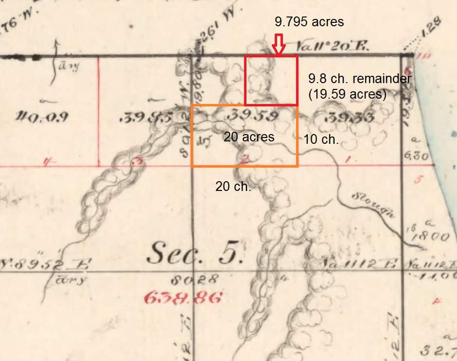
1901 Warranty Deed: "The Northeast 9.795 acres of Gov't. Lot 2 in Section 5.."
Could you post an excerpt of the 1903 Plat?
What did the grantor who created this description actually own?
The description implies the point of beginning is on the rimrock which I take to be a topographic feature as opposed to a stone lying there somewhere.
Dave Karoly, post: 364937, member: 94 wrote: Could you post an excerpt of the 1903 Plat?
What did the grantor who created this description actually own?
The description implies the point of beginning is on the rimrock which I take to be a topographic feature as opposed to a stone lying there somewhere.
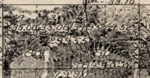
It's hard to read, the area in Lot 2 with 34 and 55 is about where the description is, it also calls the POB to be north of the stream:

the river is actually in lot 1, and it hasn't moved probably since ice was covering the area.
the ranch owned all of section 17
Interpreting the description with the information the grantor had, I would take it to mean a roughly squarish parcel surrounding the number 55 (it could be part of 299.55). That could be about 20 acres. The 55 looks like it's in a valley, maybe that's where the intersecting stream is?
But the problem is the actual topography is shifted considerably northeast.
Therefore this description would be in reality part of Lot 1, Lot 2, and the southeast 80. I wouldn't have a problem disregarding the call for the P.O.B. because it doesn't fit and fitting the parcel to the actual ground intended to be transferred.
Did the grantor have title to the area the description appears to cover. If yes, then I would fit the description to the ground out there (if that can be done, even approximately) and not worry too much about the exact relationship to the center quarter.
But since it is such a large discrepancy I think the interested owners need to be involved in the fix; a surveyor can say I think it goes here but the current owners have to agree to that (or litigate it).
Dave Karoly, post: 364954, member: 94 wrote: Interpreting the description with the information the grantor had, I would take it to mean a roughly squarish parcel surrounding the number 55 (it could be part of 299.55). That could be about 20 acres. The 55 looks like it's in a valley, maybe that's where the intersecting stream is?
But the problem is the actual topography is shifted considerably northeast.
Therefore this description would be in reality part of Lot 1, Lot 2, and the southeast 80. I wouldn't have a problem disregarding the call for the P.O.B. because it doesn't fit and fitting the parcel to the actual ground intended to be transferred.
Did the grantor have title to the area the description appears to cover. If yes, then I would fit the description to the ground out there (if that can be done, even approximately) and not worry too much about the exact relationship to the center quarter.
But since it is such a large discrepancy I think the interested owners need to be involved in the fix; a surveyor can say I think it goes here but the current owners have to agree to that (or litigate it).
They have 4 bounds, the river, the two rims, and the N-S center, figuring out the south rim and the south entrance to the river is the difficult part, there is no occupation besides two cabins and a road.
These parties aren't in any dispute over this, the ranch owns hundreds of square miles and this isn't on their radar, we would lay out the deed as described and they won't care.
The GIS isn't making it easier, they don't even include the cabin sites
MightyMoe, post: 364962, member: 700 wrote: They have 4 bounds, the river, the two rims, and the N-S center, figuring out the south rim and the south entrance to the river is the difficult part, there is no occupation besides two cabins and a road.
These parties aren't in any dispute over this, the ranch owns hundreds of square miles and this isn't on their radar, we would lay out the deed as described and they won't care.
The GIS isn't making it easier, they don't even include the cabin sit"es
I would not have a problem disregarding the call for the north-south center (natural monuments control over artificial monuments) if the other 3 bounds can be made to fit and it includes the cabin sites and the road. That is assuming the original grantor had title to the actual possessions conveyed or they gained title later (the Doctrine of After Acquired Title may apply).
I would envision the original grantee wanting to acquire a certain area of about 20 acres and the scrivener they hired used a plat to attempt to encompass that area in a description which we now find out is way off where it really is.
"If a deed is ambiguous, then it's interpretation becomes a question of fact." -å¤ 177.Questions of fact, 26A C.J.S. Deeds å¤ 177
"The main object in construing a deed is to ascertain the intention of the parties." -å¤ 178.Determination of parties' intent, 26A C.J.S. Deeds å¤ 178
"Ordinarily an interpretation which plainly leads to injustice should be rejected, where a doubt arises as to the real intention." -å¤ 184.Avoidance of injustice, 26A C.J.S. Deeds å¤ 184
"In construing a deed to ascertain the intention of the parties with respect to the property conveyed, reference may be had to the state of facts existing when the deed was made, and the court will place itself as nearly as possible in the position of the parties and interpret the language in the light of the surrounding circumstances." -å¤ 249.Attending or surrounding circumstances, 26A C.J.S. Deeds å¤ 249
"A deed should so be construed as to satisfy all of several particulars included in the description of the property where all particulars are necessary to ascertain its identity.
Where several particulars are included in the description in a deed, and they are all necessary to ascertain the identity of the land conveyed, such a construction should be given as will satisfy each particular. 1 Only such land will pass as is consistent with every particular. 2 If, however, the identity of the property may be sufficiently determined from the description thereof, including several particulars, the estate may pass, although it does not agree with some of the particulars in the description. 3" -å¤ 251.Description including several particulars, 26A C.J.S. Deeds å¤ 251
"Effect should be given to a recital as to locality where such recital is not ambiguous when applied to conditions on the ground and where it is sufficiently accurate to show the place intended.
Where a recital in a deed as to locality is not ambiguous when applied to facts on the ground and is sufficiently accurate to show what place is intended, and a construction may be adopted that will make good sense of the entry, effect should be given thereto. 1 A part of the description which recites that the land is located in a single particular county may be considered with another part in which it is correctly recited that the tract is located in several named counties. 2" -å¤ 253.Recitals as to locality, 26A C.J.S. Deeds å¤ 253
Note: most of the quotes above are the "black letter" part of the C.J.S. section. The way C.J.S. is setup there is a brief black letter paragraph or sentence (black letter=bold) then a couple of paragraphs below with more information and exceptions. I really like it because I can scroll through really fast and quickly skip over the sections I don't need right now.
paden cash, post: 364920, member: 20 wrote: I've seen it. Not too often, but always a possibility. I mean, that's ALL they had at one point in time.
No topo calls, but here's one that took a little bit to figure out:
1901 Warranty Deed: "The Northeast 9.795 acres of Gov't. Lot 2 in Section 5.."
Sounds like a triangle to me... :-O
Jim in AZ, post: 364972, member: 249 wrote: Sounds like a triangle to me... :-O
I had to read the deeds and conveyances all around to figure it out. The key was understanding someone (surveyor?) had created a "standard" 20 acre lot in the south half of the Lot. If the "remainder" acreage was divided by two it fit the deed...and BTW the fences also!
Dave Karoly, post: 364970, member: 94 wrote: I would not have a problem disregarding the call for the north-south center (natural monuments control over artificial monuments) if the other 3 bounds can be made to fit and it includes the cabin sites and the road. That is assuming the original grantor had title to the actual possessions conveyed or they gained title later (the Doctrine of After Acquired Title may apply).
I would envision the original grantee wanting to acquire a certain area of about 20 acres and the scrivener they hired used a plat to attempt to encompass that area in a description which we now find out is way off where it really is.
"If a deed is ambiguous, then it's interpretation becomes a question of fact." -å¤ 177.Questions of fact, 26A C.J.S. Deeds å¤ 177
"The main object in construing a deed is to ascertain the intention of the parties." -å¤ 178.Determination of parties' intent, 26A C.J.S. Deeds å¤ 178
"Ordinarily an interpretation which plainly leads to injustice should be rejected, where a doubt arises as to the real intention." -å¤ 184.Avoidance of injustice, 26A C.J.S. Deeds å¤ 184
"In construing a deed to ascertain the intention of the parties with respect to the property conveyed, reference may be had to the state of facts existing when the deed was made, and the court will place itself as nearly as possible in the position of the parties and interpret the language in the light of the surrounding circumstances." -å¤ 249.Attending or surrounding circumstances, 26A C.J.S. Deeds å¤ 249
"A deed should so be construed as to satisfy all of several particulars included in the description of the property where all particulars are necessary to ascertain its identity.
Where several particulars are included in the description in a deed, and they are all necessary to ascertain the identity of the land conveyed, such a construction should be given as will satisfy each particular. 1 Only such land will pass as is consistent with every particular. 2 If, however, the identity of the property may be sufficiently determined from the description thereof, including several particulars, the estate may pass, although it does not agree with some of the particulars in the description. 3" -å¤ 251.Description including several particulars, 26A C.J.S. Deeds å¤ 251
"Effect should be given to a recital as to locality where such recital is not ambiguous when applied to conditions on the ground and where it is sufficiently accurate to show the place intended.
Where a recital in a deed as to locality is not ambiguous when applied to facts on the ground and is sufficiently accurate to show what place is intended, and a construction may be adopted that will make good sense of the entry, effect should be given thereto. 1 A part of the description which recites that the land is located in a single particular county may be considered with another part in which it is correctly recited that the tract is located in several named counties. 2" -å¤ 253.Recitals as to locality, 26A C.J.S. Deeds å¤ 253
Note: most of the quotes above are the "black letter" part of the C.J.S. section. The way C.J.S. is setup there is a brief black letter paragraph or sentence (black letter=bold) then a couple of paragraphs below with more information and exceptions. I really like it because I can scroll through really fast and quickly skip over the sections I don't need right now.
I'm not going to disregard the N-S center call, that wouldn't make any sense to this deed, but I will disregard the 700' south along the line from the center which also doesn't make sense if that is what you mean, but clearly the N-S line is a bounds call.
MightyMoe, post: 364985, member: 700 wrote: I'm not going to disregard the N-S center call, that wouldn't make any sense to this deed, but I will disregard the 700' south along the line from the center which also doesn't make sense if that is what you mean, but clearly the N-S line is a bounds call.
What I am saying is that if all the other parts of the description makes sense together, particularly the calls for natural monuments, but not with the call for the north-south centerline as a bound then the centerline could be disregarded as a bound. If a 20 acre parcel could be made to fit somewhere where it answers the other calls to natural monuments but the resulting north-south west boundary is not at the centerline that could be justified under numerous principles of Deed construction. However, I agree with you that this is beyond the authority of the Surveyor to do unilaterally. I could justify it and provide persuasive reasoning but the property owners involved would have to be persuaded for me to monument the final answer.
Dave Karoly, post: 364988, member: 94 wrote: What I am saying is that if all the other parts of the description makes sense together, particularly the calls for natural monuments, but not with the call for the north-south centerline as a bound then the centerline could be disregarded as a bound. If a 20 acre parcel could be made to fit somewhere where it answers the other calls to natural monuments but the resulting north-south west boundary is not at the centerline that could be justified under numerous principles of Deed construction. However, I agree with you that this is beyond the authority of the Surveyor to do unilaterally. I could justify it and provide persuasive reasoning but the property owners involved would have to be persuaded for me to monument the final answer.
Well, it is going to be a fun one,,,,,,,,,,
Something ambiguous to one person can be another person's daily chatter.
I worked with a newly licensed surveyor in the past that had a bad case of "everything that was not done by him was ambiguous".
Some days we find ourselves somewhat out of our element and have to learn something new go keep on keepin' on.
Then the ambiguity tends to go away until another comes along......
:plumbbob:
A Harris, post: 365028, member: 81 wrote: Something ambiguous to one person can be another person's daily chatter.
I worked with a newly licensed surveyor in the past that had a bad case of "everything that was not done by him was ambiguous".
Some days we find ourselves somewhat out of our element and have to learn something new go keep on keepin' on.
Then the ambiguity tends to go away until another comes along......
:plumbbob:
I hear ya, although with this particular legal I have identified a few......
W2SE4, 20 Ac, center of section, 700', rim closest to the present bridge,,,,,,,,,,,,,
That's 5 and I could come up with a couple more depending on how you weight things.
But at the end of the day, in my opinion it's a legal that can be placed on the ground.


