Moe Shetty, post: 377622, member: 138 wrote: Bill, are you certain of this? Think about reinforced concrete; if concrete and steel (rebar) had substantially different coefficients of thermal expansion, construction as we know it would have a much shorter life expectancy.
I agree. My wording was unclear.
David Livingstone, post: 377635, member: 431 wrote: Doesn't the chain get longer the hotter it gets? If so, I think the corrected the tape in the correct direction. Imagine a 100 foot tape that is so hot it it a foot longer. If measure a distance that is 100 feet long, the tape would show 99 feet. I also would have corrected the distance to 887.36'. My opinion, over that long a period of time, the distance has changed.
Unless I am missing something, if you pull your 100' tape which is actually 101' eight times, have you not recorded 800', but have actually measured 808'?
Top notch surveying thread. Good stuff here. :gammon::plumbbob::stakeout::stakeout::totalstation:
Thermal expansion for aggregates in concrete:
http://www.engr.psu.edu/ce/courses/ce584/concrete/library/cracking/thermalexpansioncontraction/aggregate type.htm
Most are a big fraction to as much as iron, so that says you shouldn't notice much difference in the uncorrected tape reading if it is laying on concrete at any temperature. If you correct for the tape temperature, you need to also correct for the concrete temperature to know what the concrete length would be at some standard temperature. Those corrections partially cancel out.
I didn't catch that they applied the wrong sign for the correction, but you are correct.
So this wall was constructed in 1902 and 52 years of settlement until the new mark(s) were set and measured to and then has settled for an additional 62 years.
It has approximately 35 construction joints based on the discussion... it would take less that 0.01' expansion in each joint over 62 years to make up what you are seeing in your measurement today.
You haven't physically inspected the entire wall length to ensure that there isn't some place on the wall where there is a significant gap+/- 0.20'-0.30'- is that correct?
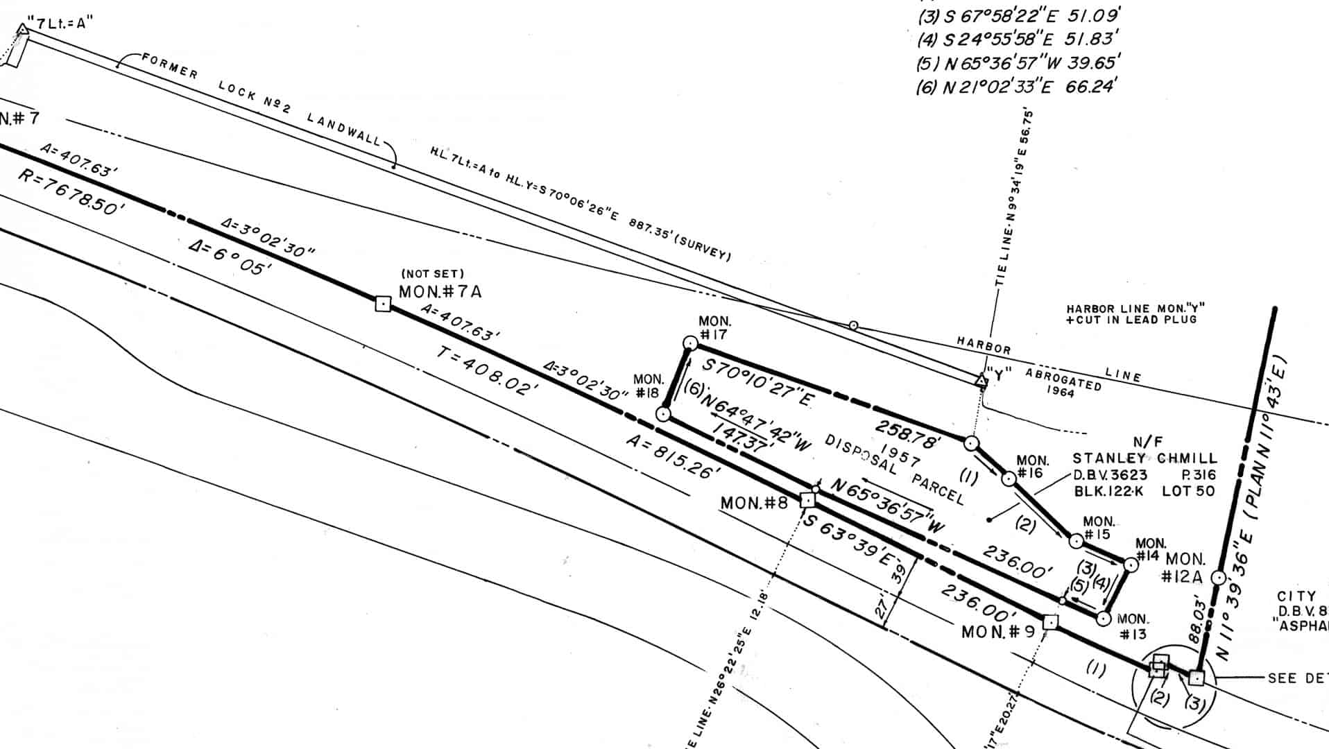
It is a complicated story, but the wall is overgrown with thick brush for about 2/3 of it. There are two adjacent property owners who are feuding, although neither actually own to the wall they both act like they do. My work has nothing to do with their feud, but once I got there it was like poking a stick into a hornets nest. Here is something else interesting that I just noticed. This is from a 1992 survey...
What is interesting is that the line between the two harbor line monuments says...887.35 (survey)! which matches the 1954 taped distance. I wonder if/how they measured it in 1992. The company that did that survey is no longer in business. The disposal parcel was subdivided in 1994, and each of them are occupying way more than what is shown, they both claim to have a "lease" from the government, but I have not been able to verify that.
The field book from the 1992 survey is missing, signed out in 1994 by who knows who.
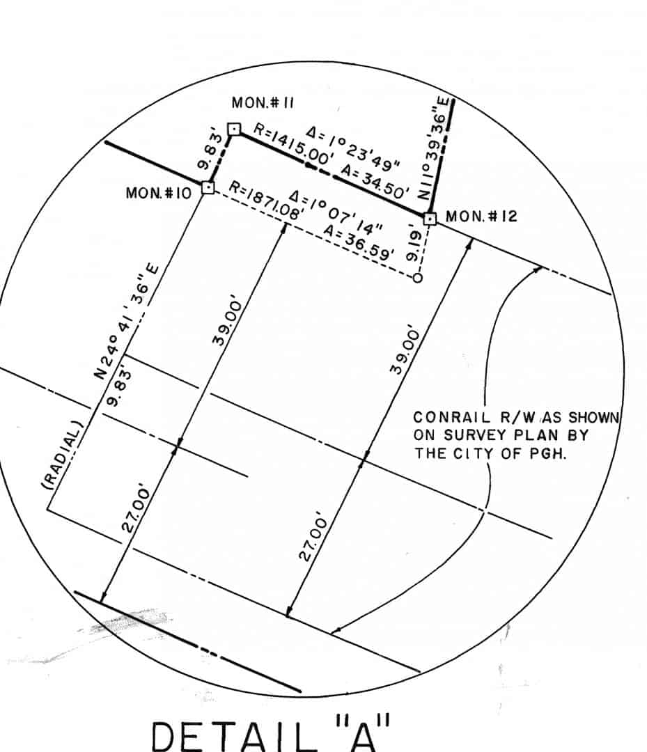
Here is another interesting thing going on out there. The circled area in the bottom right of the image above is shown below. I was able to compute it, but I say it is missing critical information (chord bearings?). Also, I got the valuation maps, and they do NOT show this jog in the RR ROW, although a similar one further west is shown on the valuation map. And, MON12 is off about 10 feet east of where the calls put it, but it definitely looks right to me. MON 10 and MON 11 are in the road (i.e. no monument), whereas MON 12 is a monument in a fence line that is city property on the other side.
Wait, you got a measurement matching within .04. Then you checked from across a river with heat waves off water surface and came up with 0.5' difference. Do you think there may be some problem with your calculations or methods?
Vern: I think you misread or misunderstood. My somewhat shaky GPS/traverse tie agrees with the shot from across the river by 0.03 feet. Therefore I have high confidence in that distance. I would trust more a distance across water than across flat ground. The distances I shot are å±0.003 m, and the angle is å±2". Centering error is 0.001 m. So, I don't know what you mean.
The computed distance disagrees with the 1954 distance by 0.5+ feet. Since I believe the temperature correction was applied with the wrong sign, that brings it down to 0.24 feet. But why does the 1992 distance (labeled as "survey" on the plat) come within 0.04 feet of the 1954 distance noted in the field book?
Maybe this wall is dancing.
When I was with the highway department there was a strong and management directed "desire" to agree with all the previous S.W.O.s (Survey Work Order). This was impossible at times due to the fact the existing monuments and the newly defined locations disagreed with record, as in your case.
The mindless division heads were adamant about reflecting the "old" record distances and locations. My only guess was that no one wanted it to appear that any record may have any error..to the point of it being ridiculous. I mean, why attempt any control at all? It really did cause unwarranted discrepancies in the construction prints that eventually followed.
My point is, you're either going to have to ignore a record distance, or your newly derived distance and location. Why they differ sometimes takes a back seat to the question "What are you going to do now?"
This is more than just resolving a difference between record and survey. As I mentioned, there are very few harbor line monuments remaining, and I wanted to use these two to extend the system several miles. So, if they are not in their original locations, that is going to be magnified as I get further away. Monday I am going to look for HL mons in a different area, about 8 miles upstream, where I previously found a few in 2003 and 2006. I would be out there today, but it is adjacent to Oakmont Country Club (US Open this week). I grew up in that area (1 block from the country club). It is all 2 lane roads around it, and traffic becomes very bad during a tournament. Actually, several of the mons in that area are on CC property, but the golf course is quite a bit above the river (about 200 or more feet in elevation.
From the original notes it was only chained one direction. So there was no redundancy! Who says they read the chain correctly. The .45 in the notes could have been .95 in the peg book, especially the way the note keeper wrote his fours.
I also agree with Paden above. In my younger years we would not argue with the record, we would just hold one end and prorate or put the error in one end. It all changed with radial staking. My 2 cents, Jp
John Hamilton, post: 377395, member: 640 wrote: I got a surface distance between them by inverse of 887.831 feet. I figured I could easily be off a few tenths considering how I tied them, so today I went to the other side of the river and observed to both using a 1" instrument, 1 mm å± 1 ppm instrument, corrected for T, P, and RH, etc. I computed a distance of 887.862 feet (side-angle-side triangle solution), so the VRS/traverse tie was not too bad, off 0.03 feet or 1 cm.
My misunderstanding stems from this paragraph. i read that to indicate the initial distance agreed with record and the across the river shots disagreed by 0.5'.
ekillo, post: 377647, member: 773 wrote: Unless I am missing something, if you pull your 100' tape which is actually 101' eight times, have you not recorded 800', but have actually measured 808'?
If you tried to layout 800 feet, you are correct, you would have layed out 808 feet. If you are measuring between two known points, it works in the opposite direction.


