Reading RPLS is free for the whole profession. Members post, reply, and get the members-only rooms.


Notifications
Clear all
Software, CAD & Mapping
10
Posts
5
Users
0
Reactions
4,174
Views

Topic starter
Translate
▼
English
Spanish
French
German
Italian
Portuguese
Russian
Chinese
Japanese
Korean
Arabic
Hindi
Dutch
Polish
Turkish
Vietnamese
Thai
Swedish
Danish
Finnish
Norwegian
Czech
Hungarian
Romanian
Greek
Hebrew
Indonesian
Malay
Ukrainian
Bulgarian
Croatian
Slovak
Slovenian
Serbian
Lithuanian
Latvian
Estonian
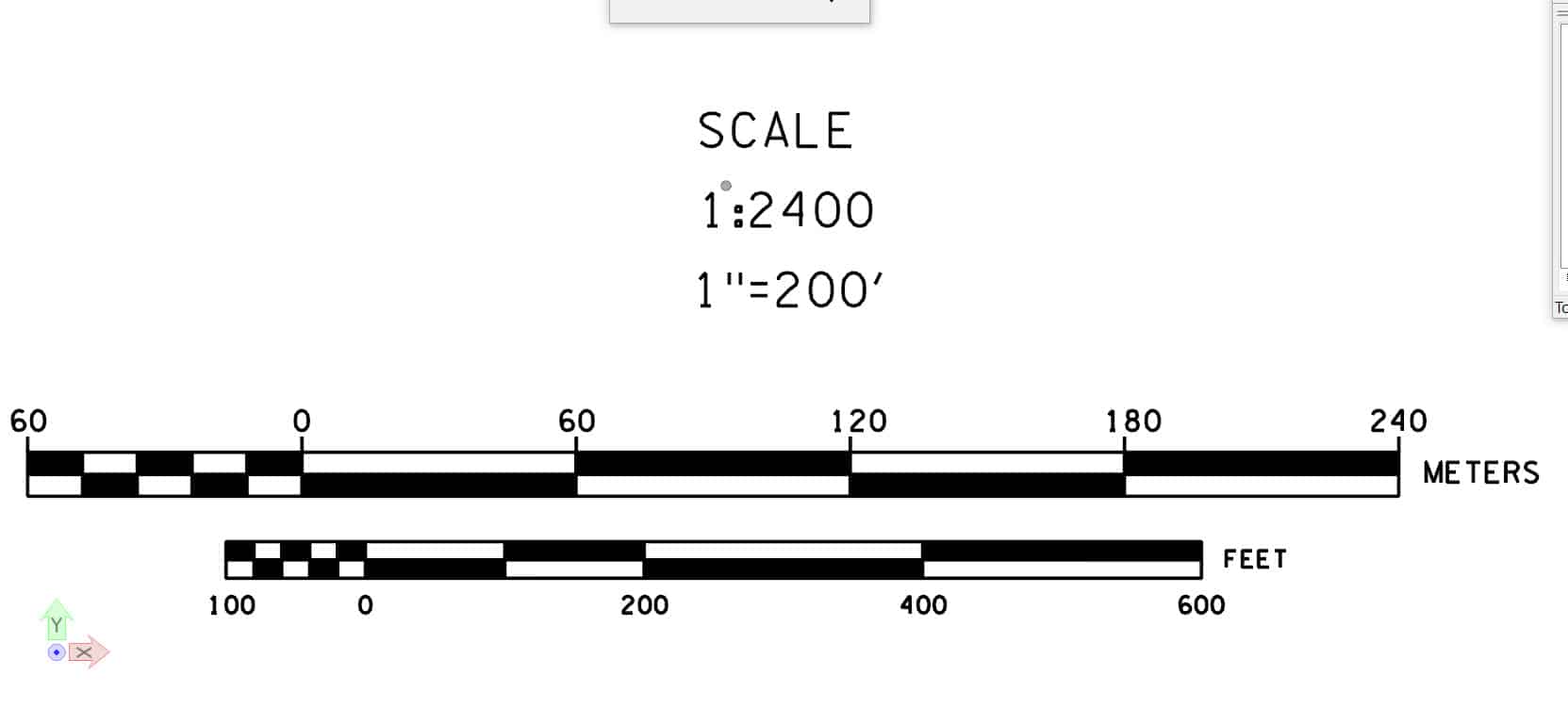
I have a client that is demanding I show both a graphic scale in meters, and in feet. I was wondering if anyone else had this issue, and what you found best way to show both scales?
I was trying to not have to show say one scale at 1"=30, and another at 1=52.24 or something similar.
Posted : May 18, 2017 10:44 am

Translate
▼
English
Spanish
French
German
Italian
Portuguese
Russian
Chinese
Japanese
Korean
Arabic
Hindi
Dutch
Polish
Turkish
Vietnamese
Thai
Swedish
Danish
Finnish
Norwegian
Czech
Hungarian
Romanian
Greek
Hebrew
Indonesian
Malay
Ukrainian
Bulgarian
Croatian
Slovak
Slovenian
Serbian
Lithuanian
Latvian
Estonian
It wouldn't be possible to show one at an even whole number and the other without some decimals.
I would make the scale of whatever units you are preparing the map in, at the whole number and the other one as a conversion.
1"= 30' = 9.144m
Posted : May 18, 2017 12:25 pm

Translate
▼
English
Spanish
French
German
Italian
Portuguese
Russian
Chinese
Japanese
Korean
Arabic
Hindi
Dutch
Polish
Turkish
Vietnamese
Thai
Swedish
Danish
Finnish
Norwegian
Czech
Hungarian
Romanian
Greek
Hebrew
Indonesian
Malay
Ukrainian
Bulgarian
Croatian
Slovak
Slovenian
Serbian
Lithuanian
Latvian
Estonian
1" = 30' would be equivalent to
1:360
1m = 360m
Shown like this.
Posted : May 18, 2017 12:44 pm
Topic starter
Translate
▼
English
Spanish
French
German
Italian
Portuguese
Russian
Chinese
Japanese
Korean
Arabic
Hindi
Dutch
Polish
Turkish
Vietnamese
Thai
Swedish
Danish
Finnish
Norwegian
Czech
Hungarian
Romanian
Greek
Hebrew
Indonesian
Malay
Ukrainian
Bulgarian
Croatian
Slovak
Slovenian
Serbian
Lithuanian
Latvian
Estonian
Is there a way for Autocad to do this, or do I have to create the scale manually?
FYI I need to have a 1"=40' scale.
Posted : May 18, 2017 1:21 pm
Translate
▼
English
Spanish
French
German
Italian
Portuguese
Russian
Chinese
Japanese
Korean
Arabic
Hindi
Dutch
Polish
Turkish
Vietnamese
Thai
Swedish
Danish
Finnish
Norwegian
Czech
Hungarian
Romanian
Greek
Hebrew
Indonesian
Malay
Ukrainian
Bulgarian
Croatian
Slovak
Slovenian
Serbian
Lithuanian
Latvian
Estonian
You don't need to do anything special in AutoCAD, just create the scale bar as a block (Acad) or Cell in (Microstation) and put it in the border.
Just multiply by 12.
You are over thinking this.
When you plot at 1"=40' it is the same as
1:480
1m = 480m
1' = 480'
1" = 480"
Posted : May 18, 2017 1:30 pm
Topic starter
Translate
▼
English
Spanish
French
German
Italian
Portuguese
Russian
Chinese
Japanese
Korean
Arabic
Hindi
Dutch
Polish
Turkish
Vietnamese
Thai
Swedish
Danish
Finnish
Norwegian
Czech
Hungarian
Romanian
Greek
Hebrew
Indonesian
Malay
Ukrainian
Bulgarian
Croatian
Slovak
Slovenian
Serbian
Lithuanian
Latvian
Estonian
Thanks for the help guys.
I did find a way that you can have Autocad do this for you. Click Layout tools/ scale bar/ metric scale, and then you choose the length of the scale and if you want it displayed in meters or feet.
Posted : May 19, 2017 8:50 am
Translate
▼
English
Spanish
French
German
Italian
Portuguese
Russian
Chinese
Japanese
Korean
Arabic
Hindi
Dutch
Polish
Turkish
Vietnamese
Thai
Swedish
Danish
Finnish
Norwegian
Czech
Hungarian
Romanian
Greek
Hebrew
Indonesian
Malay
Ukrainian
Bulgarian
Croatian
Slovak
Slovenian
Serbian
Lithuanian
Latvian
Estonian
AutoCAD has created a Copy-n-Paste, Push button society. If one can't find a place to copy it from, they have no idea how to do it or create your own style.
I would have taken a few minutes to drawn my own bar scale, and not waste time looking for a command to do it for me.
Drafting has become a lost art.
Posted : May 19, 2017 9:10 am

Translate
▼
English
Spanish
French
German
Italian
Portuguese
Russian
Chinese
Japanese
Korean
Arabic
Hindi
Dutch
Polish
Turkish
Vietnamese
Thai
Swedish
Danish
Finnish
Norwegian
Czech
Hungarian
Romanian
Greek
Hebrew
Indonesian
Malay
Ukrainian
Bulgarian
Croatian
Slovak
Slovenian
Serbian
Lithuanian
Latvian
Estonian
I had a job about 20 years ago for our State Board of Regents, who was purchasing a city block to expand their University. The State had just passed some "Go Metric" law, and was requiring that everything on drawings be shown in both Imperial and Metric Units (The thinking was that this would make it easy for us to move into the metric world). I warned them that the drawing was going to be too cluttered and busy to comprehend, but they insisted, demanding 1 foot contours as well as 1 meter contours. We performed exactly as directed and mailed off the original and the required number of prints. Several months went by and I got a call from the fellow who ordered the work. "We're looking at your drawing but its too cluttered to comprehend." I reminded him that that was exactly what I had told him. He said "Is there anyway you could produce two new drawings - one Imperial and one Metric? We'll pay whatever it costs" And they did. And our profit was fantastic. Several years later the Metric bill was either repealed or ignored.
Posted : May 19, 2017 10:48 am
Translate
▼
English
Spanish
French
German
Italian
Portuguese
Russian
Chinese
Japanese
Korean
Arabic
Hindi
Dutch
Polish
Turkish
Vietnamese
Thai
Swedish
Danish
Finnish
Norwegian
Czech
Hungarian
Romanian
Greek
Hebrew
Indonesian
Malay
Ukrainian
Bulgarian
Croatian
Slovak
Slovenian
Serbian
Lithuanian
Latvian
Estonian
Been there.
NYSDOT design survey and civil engineering projects went to metric units from 1996 to 2006. We are still working in n construction with metric units on projects designed 10 years ago.
For eminent domain processing we create ROW maps, and deed descriptions with distances, and area shown both units, Meters and US feet. Stationing was in meters. Is was quite a challenge to draft all that information on the plat. I wrote a few routines in InRoads and MicroStation to eliminate the need to manually compute between units.
I have had to work with units of chains, rods, roods, perch, US feet, inches and meters in the same project. Many old deeds in chains and rods during comps of original bounday. The map in meters and US feet. Then have to layout in inches for the carpenters on bridge's.
Posted : May 19, 2017 1:34 pm

Translate
▼
English
Spanish
French
German
Italian
Portuguese
Russian
Chinese
Japanese
Korean
Arabic
Hindi
Dutch
Polish
Turkish
Vietnamese
Thai
Swedish
Danish
Finnish
Norwegian
Czech
Hungarian
Romanian
Greek
Hebrew
Indonesian
Malay
Ukrainian
Bulgarian
Croatian
Slovak
Slovenian
Serbian
Lithuanian
Latvian
Estonian
I think all DOT's went metric for a short time in the 90's. The Fed's required it to receive federal tax dollars. That got nixed when Bush 2 came into office. Funny thing was that ODOT had gone completely metric and then switched back. For the life of me I can not figure out why we are the only country in the world that still uses the English system. For gods sake, the English don't even use it.
Posted : May 21, 2017 6:37 am