Reading RPLS is free for the whole profession. Members post, reply, and get the members-only rooms.


Notifications
Clear all
Photogrammetry, LiDAR & UAS
3
Posts
2
Users
0
Reactions
1,070
Views

Topic starter
Translate
▼
English
Spanish
French
German
Italian
Portuguese
Russian
Chinese
Japanese
Korean
Arabic
Hindi
Dutch
Polish
Turkish
Vietnamese
Thai
Swedish
Danish
Finnish
Norwegian
Czech
Hungarian
Romanian
Greek
Hebrew
Indonesian
Malay
Ukrainian
Bulgarian
Croatian
Slovak
Slovenian
Serbian
Lithuanian
Latvian
Estonian
When we have LIDAR flown for a transmission project we have obliques taken. We get a excel speadsheet that shows the following information on each photo:
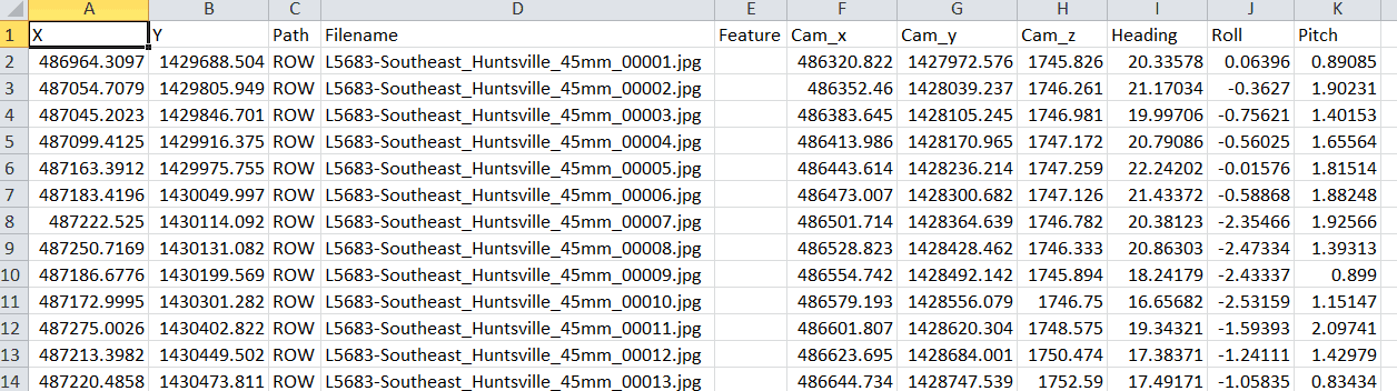
So I may have 500 photos for a route. Has anyone ever created a script or a program that would create a kml that would overlay the photos in GE? If not it will be fun to write.
Posted : May 5, 2016 12:41 pm

Translate
▼
English
Spanish
French
German
Italian
Portuguese
Russian
Chinese
Japanese
Korean
Arabic
Hindi
Dutch
Polish
Turkish
Vietnamese
Thai
Swedish
Danish
Finnish
Norwegian
Czech
Hungarian
Romanian
Greek
Hebrew
Indonesian
Malay
Ukrainian
Bulgarian
Croatian
Slovak
Slovenian
Serbian
Lithuanian
Latvian
Estonian
You can use DNR Garmin, free from Minnesota Dept. of Natural Resources, to convert spreadsheet data directly to kml. Here's the web site for the download: http://www.dnr.state.mn.us/mis/gis/DNRGPS/DNRGPS.html
The system can handle 30,000 or so points and can work with shape files, spread sheets, kml files, and data stored in many GPS receivers.
Posted : May 5, 2016 1:44 pm
Topic starter
Translate
▼
English
Spanish
French
German
Italian
Portuguese
Russian
Chinese
Japanese
Korean
Arabic
Hindi
Dutch
Polish
Turkish
Vietnamese
Thai
Swedish
Danish
Finnish
Norwegian
Czech
Hungarian
Romanian
Greek
Hebrew
Indonesian
Malay
Ukrainian
Bulgarian
Croatian
Slovak
Slovenian
Serbian
Lithuanian
Latvian
Estonian
Thanks I will have to check it out.
Posted : May 6, 2016 7:42 am