Reading RPLS is free for the whole profession. Members post, reply, and get the members-only rooms.


Notifications
Clear all

Topic starter
Translate
▼
English
Spanish
French
German
Italian
Portuguese
Russian
Chinese
Japanese
Korean
Arabic
Hindi
Dutch
Polish
Turkish
Vietnamese
Thai
Swedish
Danish
Finnish
Norwegian
Czech
Hungarian
Romanian
Greek
Hebrew
Indonesian
Malay
Ukrainian
Bulgarian
Croatian
Slovak
Slovenian
Serbian
Lithuanian
Latvian
Estonian
Did you know that two GPS receivers, In the wide open sky, (L-1 only is fine), set up 1/4 mile, to 2 miles apart, for 2+ hrs, and a storage rate of once per 10", will generate an accuracy between the two receivers, of 1/2" of bearing accuracy, and typically better than 0.03' for distance?
L-1 and L-2 receivers, is even better... as in 15 minutes is probably enough time, depending some on the current satellite configuration.
I know a guy, that set his L-1 and L-2 GPS up, to record once per second, and set his base in the wide open sky. He would take 2 observations, (usually 100' to 300' apart) all over the county. Then, come later and use a total station, to shoot corners back in the trees.
He was getting good results. Each observation was between 7 and 9 minutes long.
My point of this post is that GPS yields very accurate bearings.
Also, GPS is MORE accurate in some directions, (NE-SW, or NW-SE) than in others. Does anybody remember which direction is more accurate? Maybe it was NS, or something.
OK, post your "Did you know". I want to promote more understanding of the tools at hand.
Thank you,
Nate
Posted : August 26, 2017 12:32 pm

Translate
▼
English
Spanish
French
German
Italian
Portuguese
Russian
Chinese
Japanese
Korean
Arabic
Hindi
Dutch
Polish
Turkish
Vietnamese
Thai
Swedish
Danish
Finnish
Norwegian
Czech
Hungarian
Romanian
Greek
Hebrew
Indonesian
Malay
Ukrainian
Bulgarian
Croatian
Slovak
Slovenian
Serbian
Lithuanian
Latvian
Estonian
Did you know that OPUS RS requires a minimum of 15 minutes of data. And collected data is truncated to every 30 seconds on the interval no matter how you collect.
Sent from my SM-G955U using Tapatalk
Posted : August 26, 2017 12:37 pm
Topic starter
Translate
▼
English
Spanish
French
German
Italian
Portuguese
Russian
Chinese
Japanese
Korean
Arabic
Hindi
Dutch
Polish
Turkish
Vietnamese
Thai
Swedish
Danish
Finnish
Norwegian
Czech
Hungarian
Romanian
Greek
Hebrew
Indonesian
Malay
Ukrainian
Bulgarian
Croatian
Slovak
Slovenian
Serbian
Lithuanian
Latvian
Estonian
SOME stations are recording at different intervals... (Some even 1" rate!) but, many are doing 15".
I got that info from the Javad side of the coin.
N
Posted : August 26, 2017 1:22 pm

Translate
▼
English
Spanish
French
German
Italian
Portuguese
Russian
Chinese
Japanese
Korean
Arabic
Hindi
Dutch
Polish
Turkish
Vietnamese
Thai
Swedish
Danish
Finnish
Norwegian
Czech
Hungarian
Romanian
Greek
Hebrew
Indonesian
Malay
Ukrainian
Bulgarian
Croatian
Slovak
Slovenian
Serbian
Lithuanian
Latvian
Estonian
CORS stations record at various rates but OPUS only uses the 30 second epochs.
On a long observation, what I would consider traditional static surveying, there's no appreciable gain in recording at a rate faster than 15 seconds.
Posted : August 26, 2017 1:31 pm
Translate
▼
English
Spanish
French
German
Italian
Portuguese
Russian
Chinese
Japanese
Korean
Arabic
Hindi
Dutch
Polish
Turkish
Vietnamese
Thai
Swedish
Danish
Finnish
Norwegian
Czech
Hungarian
Romanian
Greek
Hebrew
Indonesian
Malay
Ukrainian
Bulgarian
Croatian
Slovak
Slovenian
Serbian
Lithuanian
Latvian
Estonian
Lee D, post: 443401, member: 7971 wrote: CORS stations record at various rates but OPUS only uses the 30 second epochs.
On a long observation, what I would consider traditional static surveying, there's no appreciable gain in recording at a rate faster than 15 seconds.
In this part of the world, reps of OPUS RS 15 min with separations work every bit as good as long observations. But ymmv
Sent from my SM-G955U using Tapatalk
Posted : August 26, 2017 1:46 pm
Topic starter
Translate
▼
English
Spanish
French
German
Italian
Portuguese
Russian
Chinese
Japanese
Korean
Arabic
Hindi
Dutch
Polish
Turkish
Vietnamese
Thai
Swedish
Danish
Finnish
Norwegian
Czech
Hungarian
Romanian
Greek
Hebrew
Indonesian
Malay
Ukrainian
Bulgarian
Croatian
Slovak
Slovenian
Serbian
Lithuanian
Latvian
Estonian
IF you are in an area where 15" or 5" or 1" data is available, and the DISTANCE to your CORS stations, is not very far, you can do alot with it.
Nate
Posted : August 26, 2017 1:48 pm

Translate
▼
English
Spanish
French
German
Italian
Portuguese
Russian
Chinese
Japanese
Korean
Arabic
Hindi
Dutch
Polish
Turkish
Vietnamese
Thai
Swedish
Danish
Finnish
Norwegian
Czech
Hungarian
Romanian
Greek
Hebrew
Indonesian
Malay
Ukrainian
Bulgarian
Croatian
Slovak
Slovenian
Serbian
Lithuanian
Latvian
Estonian
Nate The Surveyor, post: 443393, member: 291 wrote: Did you know that two GPS receivers, In the wide open sky, (L-1 only is fine), set up 1/4 mile, to 2 miles apart, for 2+ hrs, and a storage rate of once per 10", will generate an accuracy between the two receivers, of 1/2" of bearing accuracy, and typically better than 0.03' for distance?
Did you know that 2 receiver phase differential baseline processing, L1, subsecond azimuths, 5mm was normal results in 1989 with Trimvec?
Posted : August 27, 2017 7:16 pm
Topic starter
Translate
▼
English
Spanish
French
German
Italian
Portuguese
Russian
Chinese
Japanese
Korean
Arabic
Hindi
Dutch
Polish
Turkish
Vietnamese
Thai
Swedish
Danish
Finnish
Norwegian
Czech
Hungarian
Romanian
Greek
Hebrew
Indonesian
Malay
Ukrainian
Bulgarian
Croatian
Slovak
Slovenian
Serbian
Lithuanian
Latvian
Estonian
Many hundreds of surveyors don't know that 2 gps units can yield faithful bearings. Better than a sunshot. Consistently. I'd say 50% or more of surveyors don't know it.
Nate
Posted : August 27, 2017 9:27 pm
Topic starter
Translate
▼
English
Spanish
French
German
Italian
Portuguese
Russian
Chinese
Japanese
Korean
Arabic
Hindi
Dutch
Polish
Turkish
Vietnamese
Thai
Swedish
Danish
Finnish
Norwegian
Czech
Hungarian
Romanian
Greek
Hebrew
Indonesian
Malay
Ukrainian
Bulgarian
Croatian
Slovak
Slovenian
Serbian
Lithuanian
Latvian
Estonian
Many hundreds of surveyors don't know that 2 gps units can yield faithful bearings. Better than a sunshot. Consistently. I'd say 50% or more of surveyors don't know it.
Nate
Posted : August 27, 2017 9:30 pm

Translate
▼
English
Spanish
French
German
Italian
Portuguese
Russian
Chinese
Japanese
Korean
Arabic
Hindi
Dutch
Polish
Turkish
Vietnamese
Thai
Swedish
Danish
Finnish
Norwegian
Czech
Hungarian
Romanian
Greek
Hebrew
Indonesian
Malay
Ukrainian
Bulgarian
Croatian
Slovak
Slovenian
Serbian
Lithuanian
Latvian
Estonian
#'GPS, GPS, so good Nate praised it twice'!
I will post a link if I can find it for an article on using two RTK receivers on ships, one near the bow and one near the stern to give precise real time position and orientation for manoeuvring and docking in busy harbours.
Posted : August 28, 2017 8:07 am

Translate
▼
English
Spanish
French
German
Italian
Portuguese
Russian
Chinese
Japanese
Korean
Arabic
Hindi
Dutch
Polish
Turkish
Vietnamese
Thai
Swedish
Danish
Finnish
Norwegian
Czech
Hungarian
Romanian
Greek
Hebrew
Indonesian
Malay
Ukrainian
Bulgarian
Croatian
Slovak
Slovenian
Serbian
Lithuanian
Latvian
Estonian
Nate The Surveyor, post: 443405, member: 291 wrote: IF you are in an area where 15" or 5" or 1" data is available, and the DISTANCE to your CORS stations, is not very far, you can do alot with it.
Nate
You can use CORS stations to post-process field topo data, from long distances, it's amazing how well it works.
I rented units to the county to "drive" the county roads and collect data. This was back in the late 1990's. Looking at the data even 60 miles away it held up very well. This was all done base/rover, but there is no difference between CORS/rover and base/rover as far as the post-processing goes.
I used the close CORS on a site to collect some location data last year, the power supply for my base wasn't working so I was stuck. Checked into control points less that .07' using the continuous topo mode in PPK, those were just one click shots to a CORS point 50 miles to the west, and all the topo shots were good.
PPK is a very powerful underused tool for surveyors.
This type of data is collected PPK continuous topo. I will do it every 5 seconds but you can do it every 1 second if the CORS point is also collecting at that rate, can't really see the advantage of doing that however.
I've never heard of the NE-SW accuracy thing, sounds more like an XY issue in a projection than a true bearing issue.
Posted : August 28, 2017 8:37 am
Translate
▼
English
Spanish
French
German
Italian
Portuguese
Russian
Chinese
Japanese
Korean
Arabic
Hindi
Dutch
Polish
Turkish
Vietnamese
Thai
Swedish
Danish
Finnish
Norwegian
Czech
Hungarian
Romanian
Greek
Hebrew
Indonesian
Malay
Ukrainian
Bulgarian
Croatian
Slovak
Slovenian
Serbian
Lithuanian
Latvian
Estonian
gschrock, post: 443590, member: 556 wrote: Got that right Larry, high precision baseline processing was not invented in the past few years. Kids of today just don't believe it (and they should get also off my lawn). 😀 All kidding aside, there are some great books and manuals that evidence the history of GPS, GNSS, and all of the amazing things folks have done with it for decades...I really wish folks would learn more about that history and honor it...
Baseline post processing at 1000 ft was better than Invar chaining, and same-same as EDM.
___________
In about 1996 I got stuck with no NGS control for a hundred miles. That was back when displayed lat long was +/- 100 M or more. I was lost. I did have one point on site that was SPC, but no description. I occupied the only mark I could find on a gamble with good old Z12, 6+ hrs.
There was this new fangled service acronym of CORS. There were probably only 8 stations nationwide at the time. And a new, spooky, hard to use thing called Internet. I managed to find 2 CORS stations in operation on that day. (CORS data wasn't 24/7 by a long shot.) 900 mile baseline SW, and another 350 miles NW.
After an hour or two of downloading, and an hour of processing, the post-processed base baseline from Pie Town, NM, 900 mile baseline, returned a coord only 40 cm different than the un-described point I occupied. And about the same from a CORS in Nebraska, 350 miles. So I could at least confirm the point I occupied was the point on the map.
That impressed me. Shocking to think that was 21 yrs ago.
Posted : August 28, 2017 11:17 pm

Translate
▼
English
Spanish
French
German
Italian
Portuguese
Russian
Chinese
Japanese
Korean
Arabic
Hindi
Dutch
Polish
Turkish
Vietnamese
Thai
Swedish
Danish
Finnish
Norwegian
Czech
Hungarian
Romanian
Greek
Hebrew
Indonesian
Malay
Ukrainian
Bulgarian
Croatian
Slovak
Slovenian
Serbian
Lithuanian
Latvian
Estonian
Nate The Surveyor, post: 443393, member: 291 wrote: Also, GPS is MORE accurate in some directions, (NE-SW, or NW-SE) than in others. Does anybody remember which direction is more accurate? Maybe it was NS, or something.
I believe the error ellipse for a vector is what will generally dictate this. My understanding (which could be wrong) is that the error ellipse is longer in the North-South axis and shorter in the East-West axis. So a direction is going to be slightly more accurate between two points positioned in a North-South direction and the distance will have more uncertainty. Inversely, the distance between two points will have slightly better accuracy between points positioned East-West and the direction will have more uncertainty in this orientation. This is assuming that my memory is correct regarding the usual error ellipse pattern of GNSS derived positions.
Posted : August 29, 2017 8:20 am

Translate
▼
English
Spanish
French
German
Italian
Portuguese
Russian
Chinese
Japanese
Korean
Arabic
Hindi
Dutch
Polish
Turkish
Vietnamese
Thai
Swedish
Danish
Finnish
Norwegian
Czech
Hungarian
Romanian
Greek
Hebrew
Indonesian
Malay
Ukrainian
Bulgarian
Croatian
Slovak
Slovenian
Serbian
Lithuanian
Latvian
Estonian
gschrock, post: 443868, member: 556 wrote: Hi Nate, I'd have to do some digging to find the specific on this, there is a more pronounced Sagnac effect in E-W. In short, The relativistic differences in clock between the orbits and the ground is taken into account for us by the rocket scientists, but as the earth rotation is W-E and the orbits are inclined planes, there is more of a bias to account for along the path of rotation. Nice presentation at ION on this years ago.... I'll see if I can find the paper.
http://areeweb.polito.it/ricerca/relgrav/solciclos/ashby_d.pdf
Posted : August 29, 2017 8:50 am
Translate
▼
English
Spanish
French
German
Italian
Portuguese
Russian
Chinese
Japanese
Korean
Arabic
Hindi
Dutch
Polish
Turkish
Vietnamese
Thai
Swedish
Danish
Finnish
Norwegian
Czech
Hungarian
Romanian
Greek
Hebrew
Indonesian
Malay
Ukrainian
Bulgarian
Croatian
Slovak
Slovenian
Serbian
Lithuanian
Latvian
Estonian
gschrock, post: 443873, member: 556 wrote: We have to reinstate your geek merit badge
Nope...just the Distinguished Google Award with Oak Leaf Clusters
Posted : August 29, 2017 9:18 am
Translate
▼
English
Spanish
French
German
Italian
Portuguese
Russian
Chinese
Japanese
Korean
Arabic
Hindi
Dutch
Polish
Turkish
Vietnamese
Thai
Swedish
Danish
Finnish
Norwegian
Czech
Hungarian
Romanian
Greek
Hebrew
Indonesian
Malay
Ukrainian
Bulgarian
Croatian
Slovak
Slovenian
Serbian
Lithuanian
Latvian
Estonian
gschrock, post: 443872, member: 556 wrote: It was amazing what could be done with a handful of satellites and some clunky equipment. After almost 2 decades this old TI4100 (below) resurfaced in some university basement. Folks found my name in some old notes and sent it to me around 07. Without the original phase-matched antenna pair I can't do much with it, but in its day it was the cats meow. 4 SV for 4 hours max, cassette storage, and it produced enough heat to warm up the tent (and lunch). The DoD and NGS were among the first users, but plenty of these were used by universities and private entities as well (e.g. oil/gas).
Three decades passed since these came out and this thing makes me feel quite old...
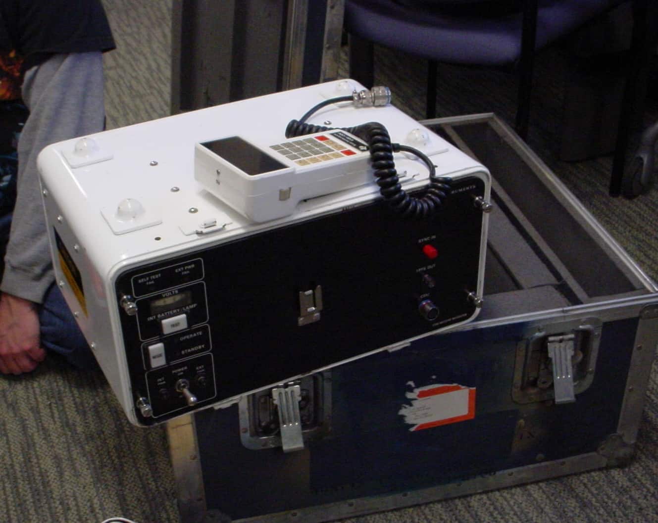
Wild WM101 had tape.
The first Trimble 4000, 5 channel L1, required a Grid portable computer for data recording, before they were called laptops. About $10K extra.
Magnavox was an early player. Codeless, phase data only. Didn't make the cut.
Whatever happened to Allen Osborne Turbo Rogue codeless receivers? You had to subscribe to companies like John Chance for ephemeris data.
The early white-papers had 4 and 5 satellite results.
Anyone remember satellite 8, block 1? Reduced to its quartz clock, you had to set 'disable navigation, survey only' because there were only 4-5 satellites.
In Argentina the only control available was established using US Navy Transit satellites.
Gps satellites were repackaged for the space shuttle. Then it blew up, and they had to revert to Delta-II. That was multi yr setback.
Oh the 80s. Tough time to make a $100K investment in gps.
Posted : August 29, 2017 10:22 am

Translate
▼
English
Spanish
French
German
Italian
Portuguese
Russian
Chinese
Japanese
Korean
Arabic
Hindi
Dutch
Polish
Turkish
Vietnamese
Thai
Swedish
Danish
Finnish
Norwegian
Czech
Hungarian
Romanian
Greek
Hebrew
Indonesian
Malay
Ukrainian
Bulgarian
Croatian
Slovak
Slovenian
Serbian
Lithuanian
Latvian
Estonian
Jawja, post: 443394, member: 12766 wrote: Did you know that OPUS RS requires a minimum of 15 minutes of data. And collected data is truncated to every 30 seconds on the interval no matter how you collect.
Sent from my SM-G955U using Tapatalk
I did know that years ago when I was doing OPUS RS session with Leica 530 units (not that it makes a difference) but I also submitted 8 minute observation files and received results. I haven't done any OPUS RS for about 8 years but if somebody would submit an 8 minute file, I would like to know if it gets rejected or processed.
Posted : August 29, 2017 10:36 am

Translate
▼
English
Spanish
French
German
Italian
Portuguese
Russian
Chinese
Japanese
Korean
Arabic
Hindi
Dutch
Polish
Turkish
Vietnamese
Thai
Swedish
Danish
Finnish
Norwegian
Czech
Hungarian
Romanian
Greek
Hebrew
Indonesian
Malay
Ukrainian
Bulgarian
Croatian
Slovak
Slovenian
Serbian
Lithuanian
Latvian
Estonian
Dave Tlusty, post: 443891, member: 311 wrote: but if somebody would submit an 8 minute file, I would like to know if it getsrejected or processed.
OPUS-RS requires a minimum of 7-1/2 minutes or it won't even try.
Posted : August 29, 2017 2:09 pm

Translate
▼
English
Spanish
French
German
Italian
Portuguese
Russian
Chinese
Japanese
Korean
Arabic
Hindi
Dutch
Polish
Turkish
Vietnamese
Thai
Swedish
Danish
Finnish
Norwegian
Czech
Hungarian
Romanian
Greek
Hebrew
Indonesian
Malay
Ukrainian
Bulgarian
Croatian
Slovak
Slovenian
Serbian
Lithuanian
Latvian
Estonian
Have you run a 7.5 min file? The submission page says 15 minutes minimum.
Posted : August 29, 2017 7:48 pm

Translate
▼
English
Spanish
French
German
Italian
Portuguese
Russian
Chinese
Japanese
Korean
Arabic
Hindi
Dutch
Polish
Turkish
Vietnamese
Thai
Swedish
Danish
Finnish
Norwegian
Czech
Hungarian
Romanian
Greek
Hebrew
Indonesian
Malay
Ukrainian
Bulgarian
Croatian
Slovak
Slovenian
Serbian
Lithuanian
Latvian
Estonian
[SARCASM]GNSS- Did you know that the average distance a crew will travel before they realize they left the data collector in the office is approximately 60 miles.... greater if the direction of travel is along a route with poor cell coverage...
did you know the distance the crew will park away from the office when they return and try to sneak in to get the data collector without being heard is about 150 ft.
[/SARCASM]
Posted : August 29, 2017 8:59 pm
Page 1 / 2
Next