thebionicman, post: 442217, member: 8136 wrote: One caveat ti the usefulness of notes..
The original notes tell you what route the original surveyor took, which makes "following the footsteps" possible.
Monte, post: 442221, member: 11913 wrote: Hmm, ok, well, I'm trying to approach this carefully, under my body armor and such... Yes, I am from Texas, so we do have our differences. I'll explain out what I can of the job I am working on this week/month. Customer called up, and says they think they have a vacancy in their land they are trying to sell. The buyer wants to clear up this piece of land before he buys. By vacancy I mean a piece of Unpatented Public School Land that was never properly surveyed out from the Republic or State of Texas and granted to a landowner, which happens by mis-survey, or by leaving a gap between railroad blocks, or by poor field notes and plats. (And yes, we have our own discussions here in the office, and we know what each other means, so I might use a wrong term here and there, but it is from habit). The owners knew of this vacancy due to there being a mineral deed having been issued in the early 1900's on this piece of State Land. The last survey they had done, found this mineral deed, so good for him for research, but then the surveyor ignored calls to survey lines, and went to the fences, taking in several acres from adjoinders that were under fence, so that will have to be addressed too. Back to the big problem. No one knows just exactly where this gap in the recorded surveys are. So we are hired to come out and figure out the mess. It starts with research. Lots of time putting together old deeds, patent records, Official copies of Field Notes, even canceled field notes, old judgements, and discussions with old-timers. After building a working sketch coming from all four directions, with possible places corners should be from all four directions, because they do not hit lines of occupation, we start looking for patterns of why they do or don't fit, and see if we can find reasons to apply magnitudes of error, such as a stretched chain, or a transit that was maybe off a couple of degrees. In this case, we found the vacancy to leave a gap that was the same size as a error in a senior survey to the north, where for some reason it fumbled over itself as it had a piece cut out. The problem is this makes the vacancy twice as large as it has ever been reported on any map previous. Our first trip to the field with this knowledge landed us 2 possible stone mounds, both in poor shape, but both the only pile of rocks anywhere in the area for over 300 yards. The search for a 3rd pile of rocks proved friutless, as it fell in the front yard of an old homesite. The 4th corner we hoped to find was in a pasture that had been cleared by a bulldozer many years ago. The dogleg portion of this vacancy we still question, as we are not certain how this part even came to exist.But, upon returning to the office, and placing what we did find in the computer, we got a call from the landowner, who had seen us in front of the old homesite. he stated he recalls cleaning up a pile of rocks there many years ago when he was younger and lived in the house. He was afraid of snakes making a den in the rocks. So far, it appears we have evidence of 3 surverys being laid out as excessive, one by about 10%, and then being ovelapped by a junior survey, which then had junior surveys placed from it's corners, and surveyed short to boot, leaving an even bigger gap before we get to the next senior survey, leaving a nice gap of Public School Land. Of course, being junior surveys, The Opinion of the Land Office may be to Adjust them to cover the gap, but we won't know that until we run the report to those guys. Same with fixing the senior junior overlap to the north. In this whole thing, we found not one witness tree, although we found several that other surveyors have claimed to be witness tress, but unless trees move, the tree at S18*E that is 22' away should not be closer than the tree that is at S 08*E at 11' away... Ok, now, if that's clear as mud, I'm sorry. If I tried to explain it better, Wendell would shoot me for having a post that took up half the internet (I'm long winded). But that's a general idea of the type of surveys we are tasked with.
An excellent response Monte, many similarities with me on the research. Interesting to note that the Crown and now NYS here also reserved gold and silver rights not that there is any of that around. I also see frequent mentions in posts from Texas about school lands and RR lands. I'm assuming that when the land was Patented a certain percentage was reserved for such? Here in NY there is usually a percentage reserved for roads and the cost of the survey "surveyors lot"
Jim
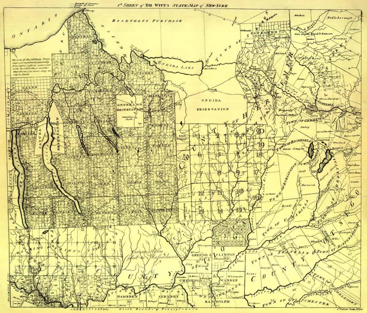
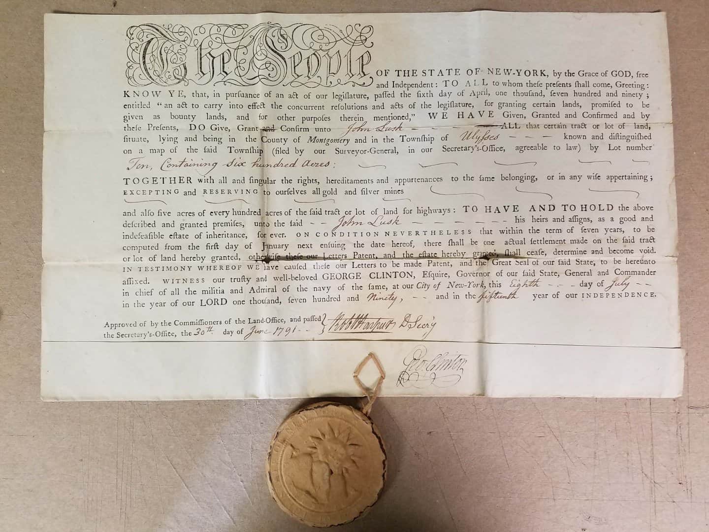
Stepping outside of the geographical area mentioned in the OP a little here but thought this map of central NY shows some interesting areas. Note the more random direction of the earlier Patents located to the East (firstly settled) and as development spread westerly, a change to something similar to the PLSS (see note in the top left corner). The "Military Tracts" are an interesting area in that the first parcels set aside for this were in the Adirondacks where it was impossible to farm. Those areas are called "the old military tract". Apparently the revolutionary war veterans demanded proper land to work and forced the state to survey and Patent off the "new military tract". Below is a Patent for just such I have in my office and a some background on it.
Jim
??John Lusk? Patent
600 Ac.
Being Lot 10 in the ??New Military Tract?, County of Montgomery
(Now Tompkins Co.) and Township of Ulysses,
Excepting all gold & silver mines and 30 ac. for road purposes
(Lake front property located on the west side of Cayuga Lake)
Issued as payment for services rendered in the ??Hamtramck? Company during the Revolutionary War.
From Appleton??s Cyclopedia of American Biography, D. Appleton and Company, New York, 1887-1889:
??Mr. Lusk was born on Staten Island on November 5, 1734; died near McMinnville, Tennessee on the June 8, 1838. He began his military career when he was about twenty years old at the conquest of Acadia. He was present at the siege of Quebec, saw General Wolfe fall on the plains of Abraham, and served in Arnold??s expedition to Canada. He was engaged in the erection of Fort Edward and was wounded there; He was at the battle of Saratoga, the surrender of Burgoyne, and also that of Cornwallis, and subsequently served under Wayne in the campaign against the Indians?
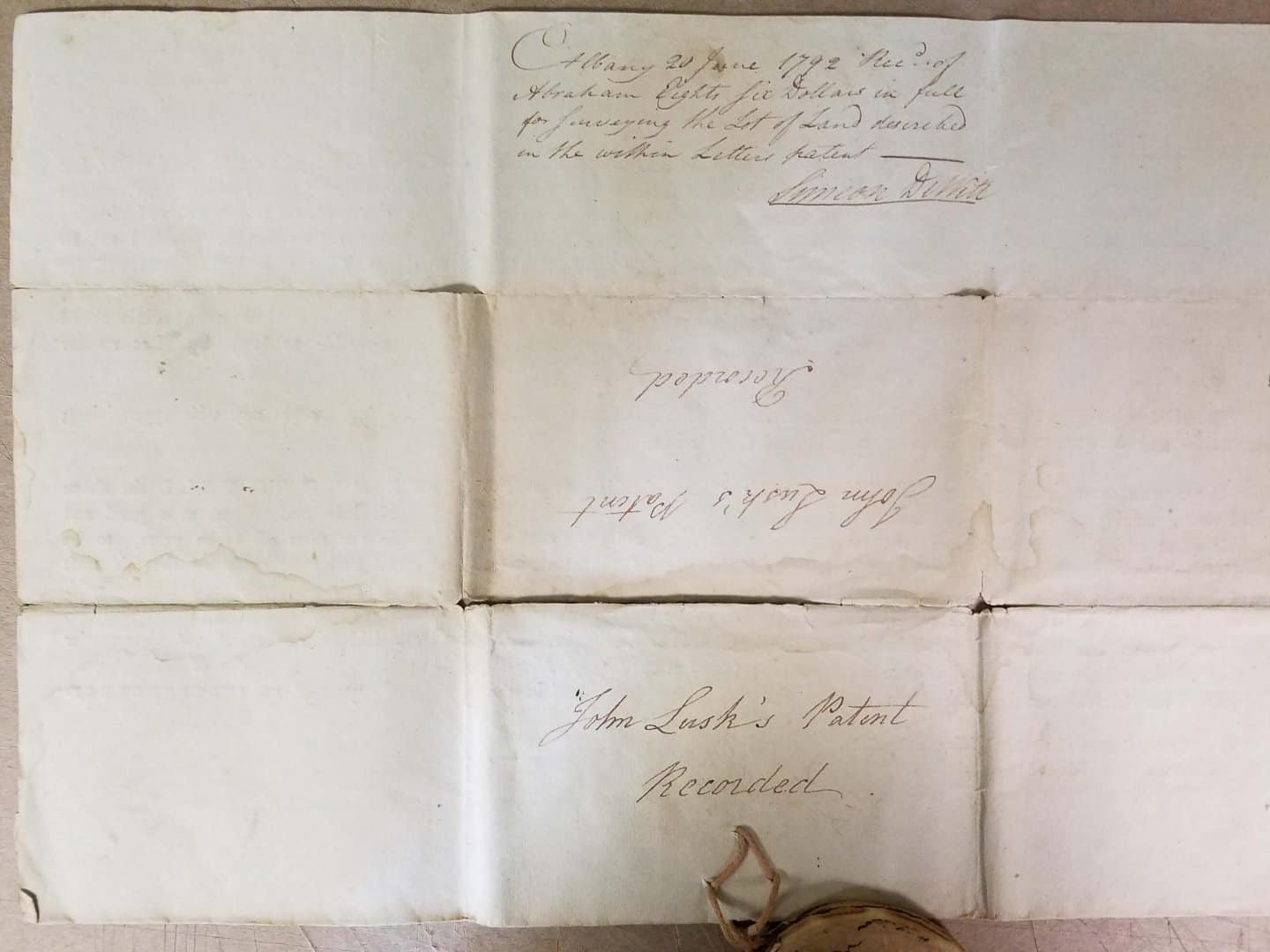
The Patent was printed in 1777 (see seal) and handed to soldiers at time of enlistment un-signed. Payment of bounties was approved by act of the state legislature, April 6, 1790. Patent signed by the first Governor of NY, George Clinton on July 8, 1790 and lastly signed (on reverse) by the second Surveyor General, Simeon DeWitt on June 20, 1792 acknowledging payment in full of $86 dollars for surveying costs.
Of special note is the rare great seal of 1777, being only in existence for one year as the design was changed in 1778.
??So, if you survived the war, lived long enough thereafter to wait for the state to approve what they promised you and paid $86 dollars for the surveying costs, the land was yours (subject to taxes of course),
Mark Mayer, post: 442230, member: 424 wrote: The original notes tell you what route the original surveyor took, which makes "following the footsteps" possible.
While that is true in THEORY, it is (unfortunately) not always the case. What the GLO/BLM refer to as "Field Notes," are in fact a highly formatted narrative strongly influenced by the Manual in effect at the time of the Original Survey. Generally speaking, the "good guys" actually ran the lines as described, unfortunately, many others did not.
That said, acquiring the "Field Notes" of a given survey is an ABSOLUTE prerequisite regardless of the veracity of said narrative.
Loyal
One thing experienced in PLSSia is related to most citizens knowing that a mile is 5280 feet so each side of a quarter section is surely 2640 and each subdivision of that will be a nice number like 1320 or 660 or 330 or 165 or 82.5. The obvious problem being that the odds of any of the true numbers agreeing with those magic numbers are incredibly small. So, Mr. Landowner has made some sort of measurement using whatever commons means available and has laid out fences or some similar evidence of possession at those distances. Then that damned surveyor comes along and tells everyone that they are in the wrong place. The instructions for initial layout of section lines by the Government contractors in my area, and many others, would have the east line of a section already established. Then the survey party would start out from what they believed to be the southwest corner of the subject section, which had already been set. Next they would traverse north 40 chains, set a monument for the west quarter corner, continue another 40 chains north and set a monument to be the northwest corner of the section. That would be followed by traversing eastward 40 chains, set a temporary north quarter corner, then traverse on until they encountered the previously set northeast corner. They would note their measurement and by how much they missed the existing monument in links to the north or south. They then headed west to the temporary north quarter corner and adjusted it to be at what they took to be the true midpoint and alignment. Their measurement may have been long or short by some number of links. Rarely was it precisely 80.00 chains unless so written in the tent later that night after the imaginary line was never run or the quarter corner was stubbed in. Thus, a large number of our east-west section lines do not measure anywhere close to 5280 feet. The north-south lines have a better chance to be very close to 80 chains, but even that was largely dependent on the terrain encountered. Corners stubbed in at 40 chains routinely introduce a nice bend point to finally reach the northeast corner, so the concept of being straight from section corner to section corner flies out the window. Thus, what is supposed to be a four-sided section is actually an 8-sided section in reality.
[USER=120]@James Vianna[/USER]
I believe James V. works in the area somewhat near where my great-great-great grandfather, Joseph A. Sweet, spent his lifetime. He represented the metropolis of Moreau on the board of supervisors for Saratoga County off and on between 1834 and 1856 as well as being the Justice of the Peace for over 30 years there. One son stayed there and followed in his father's footsteps in both roles. That was S. Mott Sweet. Another son got the heck out of there and found his way to the blissful life of PLSSia in central Illinois. That was a very good decision from my very biased viewpoint as he there met my great-great grandmother. Otherwise there would be no Holy Cow to make this post. I now own one-fourth of the quarter section they acquired as part of his compensation for spending nearly four years of his life wearing a blue uniform and visiting such friendly places as Vicksburg.
Cool stuff in this post.
1 request: Could a couple of you guys use the "enter" (or "return") key at least a few times within your posts? :imp:
Seems to effect some colonialists, expansionists and PLSSiers with equal regard. :p
Thx.
Quilty as kin bee.
Affect
PLSSians
Thanks for shearing.
Best regards
:p:p:p
Holy Cow, post: 442243, member: 50 wrote: [USER=120]@James Vianna[/USER]
I believe James V. works in the area somewhat near where my great-great-great grandfather, Joseph A. Sweet, spent his lifetime. He represented the metropolis of Moreau on the board of supervisors for Saratoga County off and on between 1834 and 1856 as well as being the Justice of the Peace for over 30 years there. One son stayed there and followed in his father's footsteps in both roles. That was S. Mott Sweet. Another son got the heck out of there and found his way to the blissful life of PLSSia in central Illinois. That was a very good decision from my very biased viewpoint as he there met my great-great grandmother. Otherwise there would be no Holy Cow to make this post. I now own one-fourth of the quarter section they acquired as part of his compensation for spending nearly four years of his life wearing a blue uniform and visiting such friendly places as Vicksburg.
Cow,
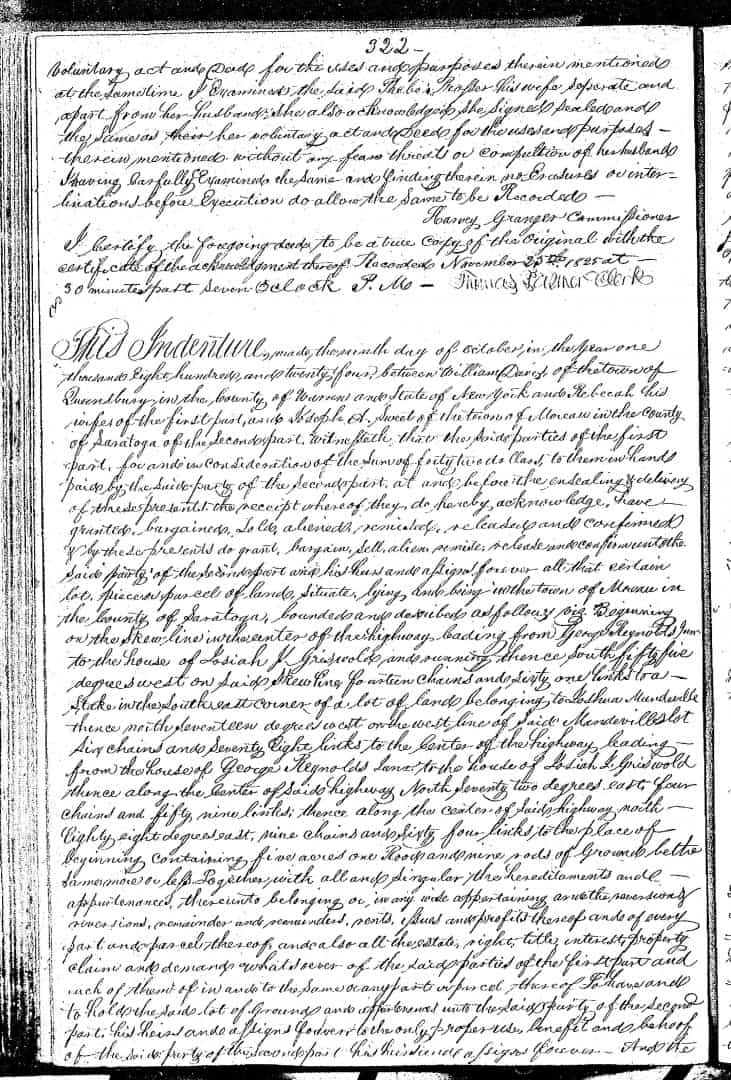
you made this to easy, I found 7 conveyances into Joseph A. Sweet between 1791 (When Saratoga County was formed) and 1869. I did not look for later ones or at the earlier Albany County records before 1791. Here are the first two:
Mark Mayer, post: 442230, member: 424 wrote: The original notes tell you what route the original surveyor took, which makes "following the footsteps" possible.
Agreed. My point related to resolving multiple sets of tracks and was intended for those unfamiliar with current BLM policy. A common theme is to accept things with a connection to the original corner. A monument set in place of a stone may be held meaningless if the original corner was a post...
Holy Cow, post: 442248, member: 50 wrote: Quilty as kin bee.
Affect
PLSSians
Thanks for shearing.
Best regards
:p:p:p
Cow send me an e-mail jviannapls at aol.com I have a few items on your ancestry you may be interested in.
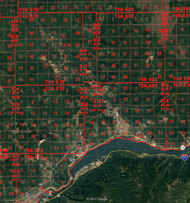
Mark Mayer, post: 442176, member: 424 wrote: I'm going to have to spend a little time looking into this. That s the Columbia River to the south. Section 54?
The aerial Mark posted is misleading since it shows Donation Land Claims with the tract number which appear like a section number (37, 39 etc.) The area I hate is where I'm working on a court case currently. Range 7-1/2 has the same sections numbers as Range 7 so you have a Section 36 corner to a Section 36-1/4 corner and Section 36 Closing Corners for the adjoining Range on the same line. It reads like Section 36-3n-7e SW corner, Section 36-3n-7-1/2e SW corner (CC) and so on to the north. Donation Land Claims mixed in, steep ground with poison oak to grab when you slip, occupation lines which don't fit anything. One area has a slide which has be documented from the Oregon side of the river since no monuments stay where set, and the distance changes from the section corners to the accessories by feet after a few years. Absolutely heaven for field work.
Son of a gun! According to James V., one of the old surveyors whose work he follows must be some sort of cousin of mine. He has the same surname as my great-great-great grandmother's family. They were among some of the earliest settlers there, so that makes sense.
Imagine that! Me with a Colonial States surveyor in the family, even if it was a long time ago.
In thinking over some of the responses, one interesting difference has come up. Namely, in the particular Patent I mentioned and most of the original 1700's era surveys I am familiar with in the Adirondacks, the idea of marking corners with permanent markers did not exist. The standard practice seems to have just been blazing and scribing of corner trees. In PLSS areas it seems corners were actual set with some being marked stones found today.
This was a major problem for Verplanck Colvin in the late 1800's trying to retrace the original surveys done 100 years prior. Fortunately he had the presence to set permanent monuments that can be found today.
In my area, we are left with second, third and fourth generation assumed perpetuations of the original evidence.
Jim
