Hello family!!!
I am yet a novice in the surveying world...seeking assistance on this area regarding tropospheric models used in different network adjustment software packages.
I am using Trimble Business Center (TBC) version 3.5, Carlson SurveyGNSS 2016 (demo),GNSS Solutions Version 3.8.0 and Leica Geo Office (LGO) for doing my final year research project at undergraduate level.
I would like to get some assistance on the tropospheric models used by any of the above software packages, amongst the models; Hopfield, Sastamoinen and Neil.
- Which model is used for tropospheric corrections in TBC, LGO, GNSS Solutions and Carlson SureyGNSS?
- Can a user of any of the packages choose a model of his/her choice to apply on static observation data?
- How do I check the models used by the different software packages?
Any other assistance in reference to the above is highly appreciated
Thanks in advance for any assistance
Kind Regards
I think you mean baseline processing packages, not network adjustment, although the baseline processors do use least squares in the processing.
I can only speak as a user of TBC. As far as I know, they do not give a choice of models, nor do they specify which one is being used.
John Hamilton, post: 453073, member: 640 wrote: I think you mean baseline processing packages, not network adjustment, although the baseline processors do use least squares in the processing.
I can only speak as a user of TBC. As far as I know, they do not give a choice of models, nor do they specify which one is being used.
Thanks Mr Hamilton for the correction and for your idea.... am grateful
You might want to look into PAGES, which is from the National Geodetic Survey. It does have a number of choices for tropospheric modeling. Free.
ftp.ngs.noaa.gov/pub/pnt6
John Hamilton, post: 453076, member: 640 wrote: You might want to look into PAGES, which is from the National Geodetic Survey. It does have a number of choices for tropospheric modeling. Free.
ftp.ngs.noaa.gov/pub/pnt6
Checking out PAGES... thank you sir
A good tropospheric model requires meteorological input that is outside the GPS receiver's capabilities. I am aware of no commercial product that allows such input.
Tropospheric delay is most important for good elevations. Here in the US we have an alternative for good elevations and that is to use OPUS-RS. The software used by OPUS-RS uses GPS receiver capability beyond the L1 and L2 signal. It also uses the C1 or P1 and the P2 and/or C2(newest satellites) to build a tropospheric delay for each CORS location. Before it solves your location it solves for up to 9 CORS that surround your receiver, then uses your receiver's reported raw position to create a tropo delay for your position. with that delay model it can do a second solution including you receiver and report much better elevations with shorter than OPUS receiver files. If the reported raw position is wrong in your files it can incorrectly pick the surrounding CORS to use.
Paul in Pa
I would expect that the user manuals would at least list the model used or those available.
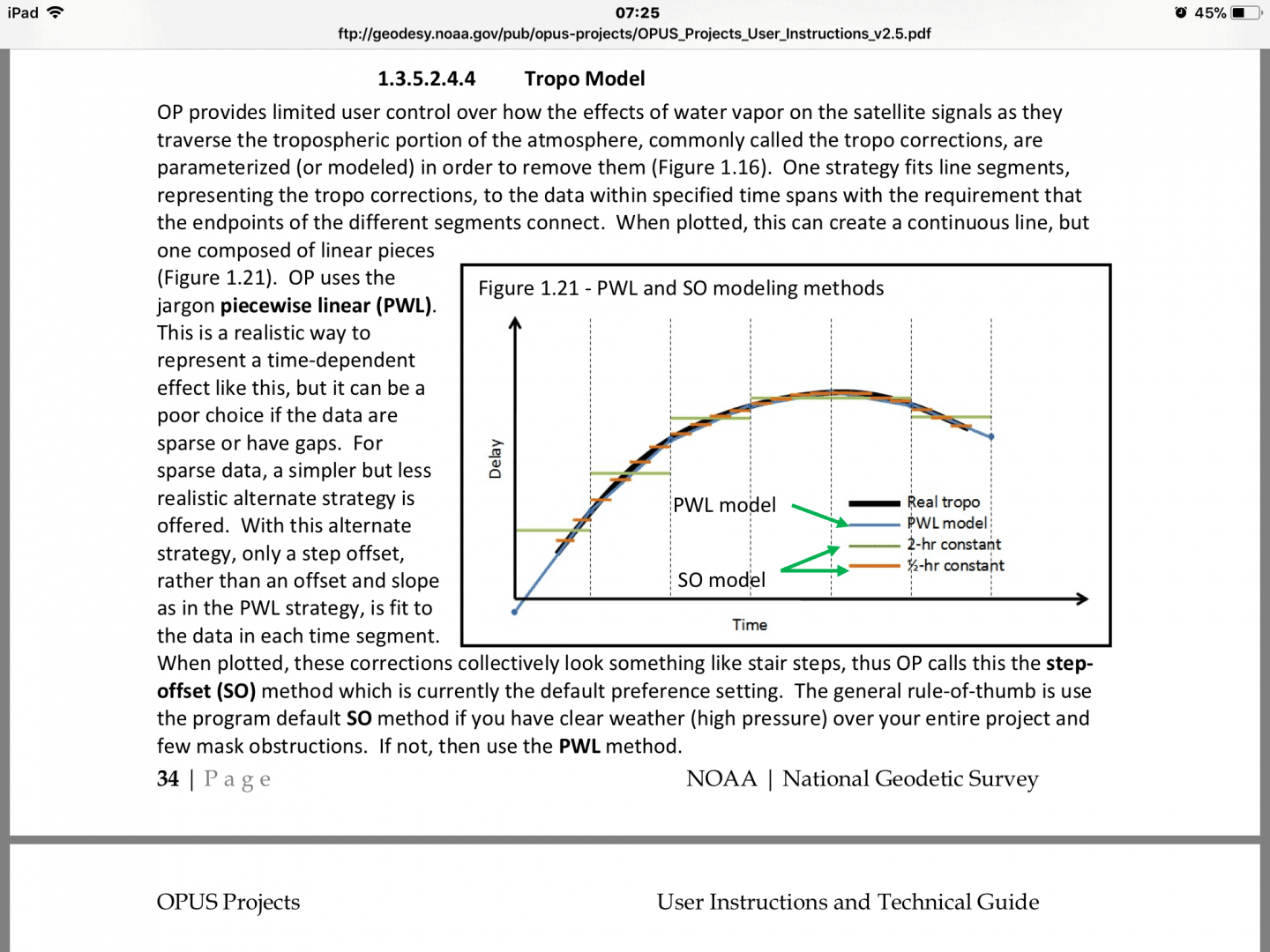
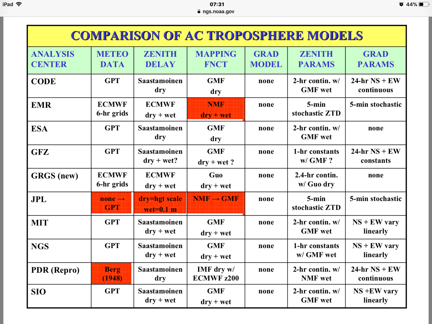
As for the government/university tropo modeling and the related issue of time parameterization, see the image files and https://www.ngs.noaa.gov/IGSWorkshop2008/docs/models-ray.pdf As you are pursuing an academic interest, use these as starting points.
I seem to remember that TGO (predecessor to TBC) had choices. I looked in the help file for TBC 3.82, could not find any mention, but I just did a cursory search only
From the help file for TBC v4.0 -
tropospheric correction (tropo correction)
The correction applied to a satellite measurement to correct for tropospheric delay. This value is obtained from the modified Hopfield model.
GeeOddMike, post: 453096, member: 677 wrote: I would expect that the user manuals would at least list the model used or those available.
As for the government/university tropo modeling and the related issue of time parameterization, see the image files and https://www.ngs.noaa.gov/IGSWorkshop2008/docs/models-ray.pdf As you are pursuing an academic interest, use these as starting points.
Thanks for this material Mr Mike
FairleyWell, post: 453142, member: 12279 wrote: From the help file for TBC v4.0 -
tropospheric correction (tropo correction)
The correction applied to a satellite measurement to correct for tropospheric delay. This value is obtained from the modified Hopfield model.
I appreciate that sir...thanks
Correctly estimating the impact of the wet part of the troposphere remains a significant impediments to achieving accurate ellipsoid heights using GNSS.
TGO did allow users to distort their results by allowing them to manipulate tropo parameters. I did a little testing years ago using TGO (circa 1997) to determine the impact of modifying the defaults; it showed me they were there for a reason.
As can be seen in the approaches to tropo estimation by the various IGS Analysis Centers (see image in post above), there are still differing approaches. Most have adopted the Saastamoein model for wet effects. The dry effect is well determined.
Note as well the use of mapping functions.
An interesting article on the issue is here: https://www.ncbi.nlm.nih.gov/pmc/articles/PMC4801563/
As for the recommendation to learn the ??free? PAGE-NT GPS processing software package, it is free only if you don??t account for the significant amount of time to learn to use it properly. In fact, it can take a significant amount of time to get it up and running on Windoze systems.
HTH,
DMM
GeeOddMike, post: 453166, member: 677 wrote:
As for the recommendation to learn the ??free? PAGE-NT GPS processing software package, it is free only if you don??t account for the significant amount of time to learn to use it properly. In fact, it can take a significant amount of time to get it up and running on Windoze systems.HTH,
DMM
Roger that!
I participated in a 16 hour PAGES NT training session @ the Jedi Temple in Silver Spring back in 2007.
Peter Lazio arranged the session, Richard Foote (NGS) was the instructor, and it was attended by Peter, John Hamilton, Mike Potterfield, and yours truly.
It was certainly worth the trip, and there is more to PAGES than just "mashing the ENTER Key."
Loyal
I agree, I have used PAGES to process data for PACS/SACS (not my choice, it was a requirement). The troposheric parameter choices are very confusing and, in my opinion, poorly documented. Not just which model, but there are some options that are not well understood by me, at least.
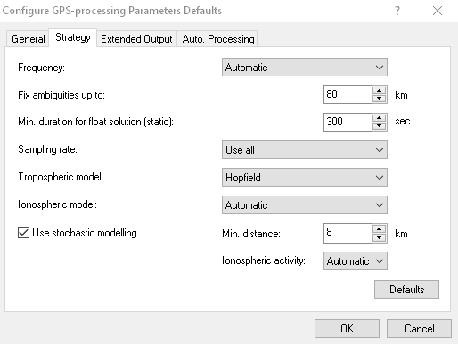
You have a few choices in Leica LGO and also can choose the iono model:
Tropospheric model:
The troposphere, that part of the atmosphere up to a height of about 30 kilometers causes a delay in the propagation of electromagnetic waves such as those used in GPS. To compute this delay the behavior of the refractive index for the troposphere must be known. Various models exist (all based on information of pressure, temperature and relative humidity of the ground station) which allow this path delay to be computed.
LGO offers the following choice of models:
- Hopfield
- Simplified Hopfield
- Saastamoinen
- No troposphere
- Computed
The differences that result from using different models are small (a few millimeters). It is recommended that the locally??used model is adopted for all computations in a particular country or area. If you are not familiar with any of these models use the system default Hopfield.
The model No troposphere does not apply any corrections and should not be used for practical purposes. It might however be interesting for investigation purposes.
Select Computed if you want to calculate variations of the tropospheric zenith delay between reference and rover from epoch to epoch. This may be advisable for longer baselines or for baselines with a larger height difference. In these cases tropospheric conditions are assumed to vary over the time or to be different on reference and rover. Selecting the option Computed will improve the height component of the processed baseline.
SHG
Shelby H. Griggs PLS, post: 453208, member: 335 wrote: You have a few choices in Leica LGO and also can choose the iono model:
Tropospheric model:
The troposphere, that part of the atmosphere up to a height of about 30 kilometers causes a delay in the propagation of electromagnetic waves such as those used in GPS. To compute this delay the behavior of the refractive index for the troposphere must be known. Various models exist (all based on information of pressure, temperature and relative humidity of the ground station) which allow this path delay to be computed.LGO offers the following choice of models:
- Hopfield
- Simplified Hopfield
- Saastamoinen
- No troposphere
- ComputedThe differences that result from using different models are small (a few millimeters). It is recommended that the locally??used model is adopted for all computations in a particular country or area. If you are not familiar with any of these models use the system default Hopfield.
The model No troposphere does not apply any corrections and should not be used for practical purposes. It might however be interesting for investigation purposes.
Select Computed if you want to calculate variations of the tropospheric zenith delay between reference and rover from epoch to epoch. This may be advisable for longer baselines or for baselines with a larger height difference. In these cases tropospheric conditions are assumed to vary over the time or to be different on reference and rover. Selecting the option Computed will improve the height component of the processed baseline.
SHG
Thank you so much Mr Griggs, I think I now know what to do in LGO thanks to such an elaborate explanation......am sincerely grateful
Ochen Ronald Keddy, post: 453240, member: 13019 wrote: Thank you so much Mr Griggs, I think I now know what to do in LGO thanks to such an elaborate explanation......am sincerely grateful
In fairness, most of the post was a cut and paste from the LGO help files, glad it is of some benefit, however I can't take the credit for the content.
SHG
Shelby H. Griggs PLS, post: 453244, member: 335 wrote: In fairness, most of the post was a cut and paste from the LGO help files, glad it is of some benefit, however I can't take the credit for the content.
SHG
I appreciate the fact that you shared it sir


