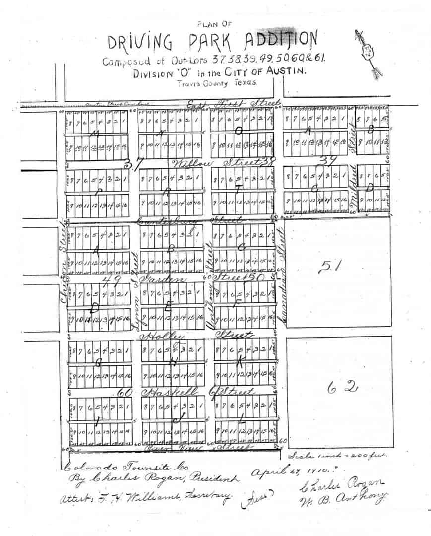
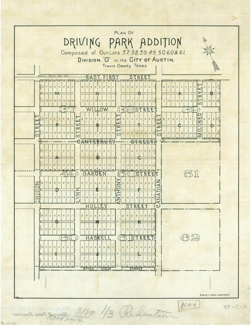
From time to time, I've posted examples of surveyor's reports that give a sense of what level of investigation is sometimes required in Texas surveying. This is an another example in that continuing series, but from an urban setting dealing with a small lot in a 1910-vintage subdivision. The attached report describes the findings of a survey that I made last year in connection with a dispute that had arisen as to the location of the common boundary between two lots in what is known as DRIVING PARK ADDITION laid out in 1910. The land subdivided is bounded by streets originally laid out in 1840 as a part of the subdivision of the so-called Government Tract that the Republic of Texas had acquired for the establishment of the City of Austin as the new capital of Texas.
In case they are of interest, here are the map and the accompanying report. Yes, the map was plotted on a pen plotter and, yes, they both it and the report are an argument in favor of the recording of such things. Since we do not have the means to do that aside from the subdivision process or in connection with land transactions, the second best option was to provide these digital copies to the surveying section of the City of Austin Public Works Department where they should be available to anyone else researching surveys in that area. That at least is the theory.
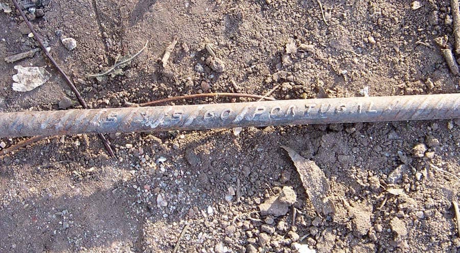
One of the bits of evidence that I didn't discuss in the report linked above was this #3 rebar that had been considered by a surveyor to control the Northwest corner of Lot 8. There was just one tiny, little problem with the rebar being some ancient survey marker. Can you tell what it is?
Looks like 2015 vintage regarding or newer. Not sure when Portuguese regarding became available stateside. That looks fresh out of home depot.
Andy Nold, post: 387342, member: 7 wrote: Looks like 2015 vintage regarding or newer. Not sure when Portuguese regarding became available stateside. That looks fresh out of home depot.
Federal records show that rebar has only been imported into the US from Portugal since 2013, which is confirmed by the mostly fresh corrosion-free surfaces on the bars. So both are of very recent origin.
Kent McMillan, post: 387341, member: 3 wrote: One of the bits of evidence that I didn't discuss in the report linked above was this #3 rebar that had been considered by a surveyor to control the Northwest corner of Lot 8. There was just one tiny, little problem with the rebar being some ancient survey marker. Can you tell what it is?
Maybe I missed something but what would the age of the rebar have to do with the acceptance. If we based our acceptance only on the age of the monumentation, what makes yours any better.
Jones, post: 387350, member: 10458 wrote: Maybe I missed something but what would the age of the rebar have to do with the acceptance. If we based our acceptance only on the age of the monumentation, what makes yours any better.
I'm not sure what you mean by "acceptance" in this situation where the West corners of Lot 8 that a surveyor reported finding marked by the new #3 rebars would fall along the East line of a public street and the other boundaries of the lot are in dispute.
Surely you don't mean that a surveyor should consider any recently set rebar with plastic ribbon tied to it as definitely fixing any property corner that it falls in the vicinity of in a subdivision laid out a century earlier.
Kent McMillan, post: 387354, member: 3 wrote: I'm not sure what you mean by "acceptance" in this situation where the West corners of Lot 8 that a surveyor reported finding marked by the new #3 rebars would fall along the East line of a public street and the other boundaries of the lot are in dispute.
Surely you don't mean that a surveyor should consider any recently set rebar with plastic ribbon tied to it as definitely fixing any property corner that it falls near in a subdivision laid out a century earlier.
Actually I do, I find it important to consider all of the evidence. When I read your other statement, it appears you disregarded it based solely on its age. I was just asking what made you disregard it, other than its age.
Jones, post: 387356, member: 10458 wrote: Actually I do, I find it important to consider all of the evidence. When I read your other statement, it appears you disregarded it based solely on its age. I was just asking what made you disregard it, other than its age.
Well, the most important fact is that it was mislocated about 0.83 ft. from where the corner was originally established and to "accept" it would slice about 0.83 ft. off of Lot 8. That and the fact that it most likely had been set by a construction subcontractor and foolishly considered by a recent survey to represent something other than a new rebar most likely set by a construction subcontractor I'm sure figured into my decision :>
From the standpoint of land surveying, the first question is "Where was the East line of Comal Street bounding Lot 8 recognized as being located by the municipal corporation having control of the same in the period between 1910 and about 1912 when the subdivision was laid out and lots originally sold?" Everything else flows from the answer to that question.
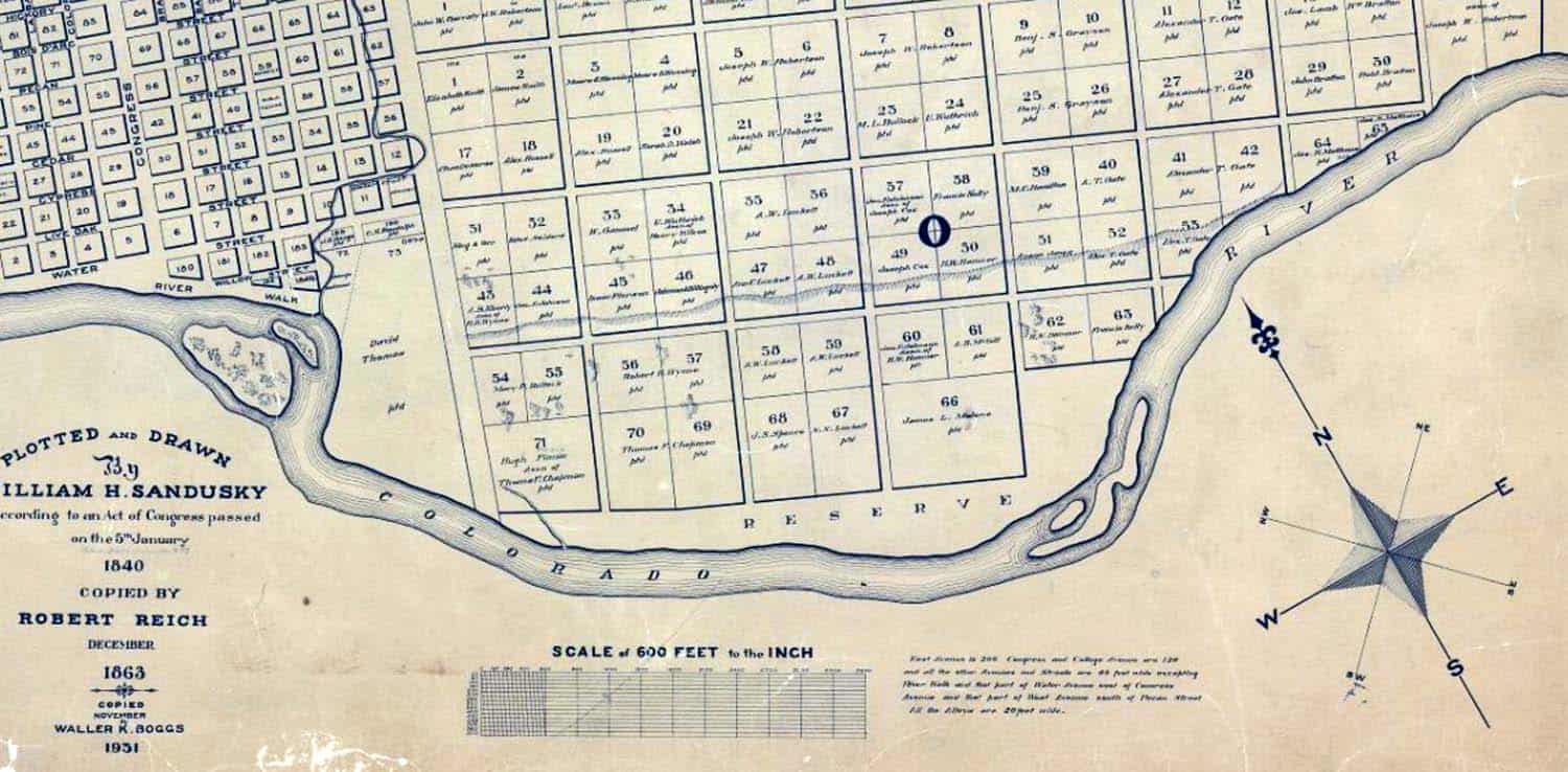
BTW, here is a detail shown what the 1840 map of the Subdivision of the Government Tract around the Original City of Austin looks like as redrawn a couple of times when the previous copy wore out from use at the Texas GLO. The numbers of the Outlots identify the locality which surrounds the "O" in Division "O" on the 1840 map.
Back in the first half of the 20th century, the Engineering Department of the City of Austin had a staff who were active in organizing the surveying of the public streets. Monument lines were established and locations were formally fixed by City Council resolutions and ordinances pursuant to those surveys. One of the ways in which the City Engineer documented the work of his department was by District Maps that showed the grid of streets, blocks, and lots according to resurveys. The District Maps (a portion of which showing the vicinity of Lot 8 in Block P of DRIVING PARK ADDITION appears below) typically give the bearings of the monument lines as well as the measured distances between the various markers along them.
For reasons that probably made sense at the time, the bearings of lines on the District Maps typically refer to the centerline of Congress Avenue, the main street of the original city as laid out in 1839, but assuming the centerline of Congress to have a bearing of N19å¡00'E. So the bearing of N22å¡53ÛªE noted on the centerline of Chicon Street as appears on one of the District Maps compiled by the City Engineer's office in 1940 really means that it has a bearing that is 3å¡53' to the right of a line parallel with Congress Avenue more than a mile to the West.
Knowing, however, that the centerline of Congress actually has a bearing of N16å¡33Ûª55ÛE with respect to grid North of the Texas Coordinate System of 1983, the grid bearing for Chicon Street would be expected from City records to be approximately N20å¡27ÛªE. I determined the East line of Chicon Street to actually have a grid bearing of N20å¡25Ûª43ÛE in relation to grid North of the Texas Coordinate System of 1983 (Central Zone), which is quite close to what one would expect from the City records.
Fast forward to 2014 and a quickie-dickie survey of Lot 8 reports a bearing of N29å¡02'10"E for the West line of Lot 8, noting that "BEARING BASIS DERIVED FROM STATE PLAIN [sic] COORDINATE SYSTEM". That line of Lot 8 is, of course, the East line of Chicon Street which actually has a grid bearing of N20å¡25'43"E in the Texas Coordinate System of 1983 (Central Zone).
Fast forward to 2015 and another quickie-dickie survey of Lot 8 (disagreeing with the 2014 survey as to the location of the common line of Lots 7 and 8 in Block P) reports a bearing of N29å¡00'00"E for the West line of Lot 8, noting that this value used as the bearing basis for the survey was "SCALED FROM TAX MAP".
Who could have ever predicted that a resurvey costing $350.00 in a 1910-vintage subdivision might not be completely reliable?
There is an area in Oklahoma City that was platted pre-statehood (1907). Apparently due to the field procedures at the time the surveyor kept projecting his meridians from block to block without any sort of major control. As the blocks approach the north and west boundary of the plat these lines became somewhat distorted. What had originally began as block corners with 90 degrees plus or minus a few minutes mutated to somewhere between 87 and 88 degrees. One of those places you have to be aware of when working in there.
A few years ago I followed a recently licensed young man's work in the area. It became evident he had used a strict 90 degree rule when laying out a portion of a block (AND ignoring 100 year old pipes that were still right where they belonged). 100 year old houses were shown as hanging off their respective lot by 5 feet or so on his survey. I eventually cleaned up his little mess.
Now for the punch line: Guess what multi-state surveying firm based in Oklahoma with which he is now employed?? 😉
paden cash, post: 387436, member: 20 wrote: A few years ago I followed a recently licensed young man's work in the area. It became evident he had used a strict 90 degree rule when laying out a portion of a block (AND ignoring 100 year old pipes that were still right where they belonged). 100 year old houses were shown as hanging off their respective lot by 5 feet or so on his survey. I eventually cleaned up his little mess.
Now for the punch line: Guess what multi-state surveying firm based in Oklahoma with which he is now employed??
Ah, I'm going to guess that it is yet another of the multi-state surveying firms that offer to sell maps that say "ALTA" on them in order to spread the awesome around!
paden cash, post: 387436, member: 20 wrote: There is an area in Oklahoma City that was platted pre-statehood (1907). Apparently due to the field procedures at the time the surveyor kept projecting his meridians from block to block without any sort of major control. As the blocks approach the north and west boundary of the plat these lines became somewhat distorted. What had originally began as block corners with 90 degrees plus or minus a few minutes mutated to somewhere between 87 and 88 degrees. One of those places you have to be aware of when working in there.
A few years ago I followed a recently licensed young man's work in the area. It became evident he had used a strict 90 degree rule when laying out a portion of a block (AND ignoring 100 year old pipes that were still right where they belonged). 100 year old houses were shown as hanging off their respective lot by 5 feet or so on his survey. I eventually cleaned up his little mess.
Now for the punch line: Guess what multi-state surveying firm based in Oklahoma with which he is now employed?? 😉
Welcome to San Francisco where everything is at a perfect 90 and measurements on 30% sloped streets are perfect despite 100 years of occupation.
Kent, I'm always amazed by these Texas surveys and your deep analysis of the problems. The time spent on these seems to be overwhelming and I constantly wonder at how you can charge the worth of your efforts, especially in this case of a small lot survey. It's much like a survey company around here (Chicago) that I bought their records extending back to around 1900. You can look at page after page (both sides) of running notes, some going on for 10 or more pages and turn to the last page and the survey was for a 25 foot lot. They resurveyed and monumented to whole subdivision, and tied in building corners along they way. I wonder at how they could do that and spend the time and money. Today, many (most) of the monuments are long gone, but the same brown stone building is on the corner, with building ties to help recreate your subdivision. -- Sorry for ramblings on, just some Sunday thoughts....
SURVEYLTD, post: 387447, member: 319 wrote: Kent, I'm always amazed by these Texas surveys and your deep analysis of the problems. The time spent on these seems to be overwhelming and I constantly wonder at how you can charge the worth of your efforts, especially in this case of a small lot survey.
These investigations are typically work I get hired to perform when there is a dispute or a claim being made with a big price tag. That was the case on the above project. My original assignment was to determine which of the two surveys was correct and the precise answer was "neither". I bill based on time and expenses and did so on that one. The client said it was great value for money considering that the dispute reportedly evaporated after my work.
I'm going to agree with Kent (?!) with his process of investigation with a "small lot survey", especially in an older urban setting. Although Texas and Oklahoma seem to be separated by more than just a riverbed when it comes to most surveying, ancient urban lots are apparently similar. And that probably applies all over the country.
Understanding how plats were laid out 100 years ago is knowledge that can take years to understand. A lot of surveying effort went into some of those early platted areas. The world was young and there was an esprit de corps in a lot of cases to perform some of the better work of the era. Sadly during the next 100 years I would bet almost every retracement survey looked upon it as a "small lot survey". So most of the post-creation surveys have probably been done in an abbreviated manner, at their best.
What makes them most interesting (at least up here in Okie-Homie) is a lot of the original monumentation still exists. And discovery is an art that a lot of surveyors slip over quickly with just a wag of a the Schonstedt. But there exists a plethora of records. And in some cases the original occupying structures still grace the properties. It can be a wonderful and evidence rich environment that requires a seasoned eye and mind to literally dig through the layers of the past that may have obscured the original geometry and field work to arrive at the truth.
I know a lot of surveyors (including myself) love expansive surveys in rural areas. But an older urban "small lot survey" can be some of the most interesting surveying out there.
I know I've eaten a lot of time on these types of surveys. I'm gonna guess if the client hired Kent, he wasn't shopping for anything that was going to happen in a day or two. 😉
paden cash, post: 387452, member: 20 wrote: I'm gonna guess if the client hired Kent, he wasn't shopping for anything that was going to happen in a day or two.
Yes, the way I usually take on projects like that is to get a retainer to cover the research and then dig into enough of the records to have some idea what will need to be done on the ground. That is what allows me to make a mildly informed guess as to how much of the world will need to be resurveyed to get a defensible answer to various questions. In that particular addition, the questions included (a) whether there was any reason to think that the lots had originally been marked by more than wood stakes when they were laid out for sale and (b) whether title to the two lots whose common line was in dispute had merged in common ownership after leaving the subdivider before reaching the present owners.
paden cash, post: 387452, member: 20 wrote: Understanding how plats were laid out 100 years ago is knowledge that can take years to understand. A lot of surveying effort went into some of those early platted areas. The world was young and there was an esprit de corps in a lot of cases to perform some of the better work of the era. Sadly during the next 100 years I would bet almost every retracement survey looked upon it as a "small lot survey". So most of the post-creation surveys have probably been done in an abbreviated manner, at their best.
Yes, that is pretty much what accounts for the nutty patchwork of little islands of land that don't fit together terribly well that tend to form in older additions. The parcel surveys have typically been regarded as separate things to be whipped together from the barest possible amount of evidence, hoping for the best. At $350 a pop, that isn't particularly any surprise.
Before about 1960 in the City of Austin, the City Engineering Department actually did a moderately good job of maintaining centerline monumentation in different older parts of the City. It wasn't perfect, but it was at least something. Those records of the period from about 1909 through 1965 continue to be of tremendous value by perpetuating evidence that is now long gone. Research usually means making a deep dive into those maps, field books, and other documents that reside in the files of former City Engineers.


