Can someone explain to me the ramifications of the project height on a GPS survey when you are setting up the coordinate system? I have never really understood what exactly this does and have always set it to the nearest 100' of the elevation at the base.
The guy that trained me told me to do it that way and it seems to work fine but then again I am not doing really precision critical work.
Are you using a local coordinate system or a predefined coordinate system? If you create a system that is to be related to the ground, then every 21 feet of elevation difference creates a 1 ppm difference in scale factor.
If you are using a predefined coordinate system, then I don't know why it matters, unless your software uses it for calculated points without a valid elevation to calculate a horizontal surface distance.
Shawn said it well; Michael Dennis gives the distortion due to changes in elevation in terms of 30 meter (100 foot) increments on page 10 (15 pdf) here: http://www.iowadot.gov/rtn/pdfs/IaRCS_Handbook.pdf
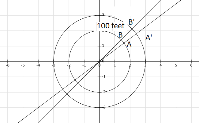
I look at it like this:
Consider the inner circle to have the equatorial radius of the GRS80 ellipsoid, 6,378,137 meters. Then consider the outer circle to have a radius that is 30 meters more, or 6,378,167 meters.
If you use the distance AB to represent the distance A'B', your error will be 4.8 parts per million. Rounding to the nearest 100 feet introduces, on average, 50 feet of error in the radius of the proper circle, or about 2.4 parts per million in computed distances.
To calculate the 4.8 ppm, consider the differences in the circumferences of the two circles. The smaller circumference is 40,075,017 meters and the larger circumference is 40,075,205 meters.
If you use the smaller one to represent the larger one, the ppm error is:
1,000,000 * (40,075,205 - 40,075,017)/40,075,205 = 4.69 ppm. This is below 4.8 because 100 feet is actually 30.48 meters, not exactly 30. Using 30.48 gives 4.77 ppm.
Drilldo, post: 367829, member: 8604 wrote: Can someone explain to me the ramifications of the project height on a GPS survey when you are setting up the coordinate system? I have never really understood what exactly this does and have always set it to the nearest 100' of the elevation at the base.
The guy that trained me told me to do it that way and it seems to work fine but then again I am not doing really precision critical work.
I know what you are talking about, it seems to be meaningless, but if you don't imput it then the file won't work.
I can put 4000 or 1000 in the same file and it doesn't change anything. As long as you chose the parameters.
I use 99999 as a dummy elevation value in my COGO calculated points, so they are obviously not on a good elevation. Once (just once) I imported into a GPS file and used those 99999 elevations to stake points out. They were all wrong, but relatively correct. I try to keep the imported calculated points within ten feet of true elevations, easy to do with the county GIS.
Thanks guys for the explanations. We are using a predefined coordinate system (SPC).
Drilldo, post: 367936, member: 8604 wrote: Thanks guys for the explanations. We are using a predefined coordinate system (SPC).
Are you having an issue with DC's in the field wanting a project height?


