AI Assistant
Notifications
Clear all

PLSS question

19 Posts
13 Users
0 Reactions
837 Views
Kris Morgan
(@kris-morgan)
Posts: 3855
Member
Topic starter
Translate
English
Spanish
French
German
Italian
Portuguese
Russian
Chinese
Japanese
Korean
Arabic
Hindi
Dutch
Polish
Turkish
Vietnamese
Thai
Swedish
Danish
Finnish
Norwegian
Czech
Hungarian
Romanian
Greek
Hebrew
Indonesian
Malay
Ukrainian
Bulgarian
Croatian
Slovak
Slovenian
Serbian
Lithuanian
Latvian
Estonian
 

Recently, a good client asked that I find him some aerials for a tract in new Mexico.

He gave me the township range section etc. When I found the gis files for the state by township, then the ranges, I found something funny. The township I was researching was only 1mile wide and six miles deep.

Is this common? It appeard to run the entire length, north to south of Lincoln county. Each township north and south only 1 mile east west with six miles north-south.

Id never even read about stuff like this in plss areas.


Posted : February 19, 2011 2:40 pm
RADAR
(@dougie)
Posts: 7880
Member
Translate
English
Spanish
French
German
Italian
Portuguese
Russian
Chinese
Japanese
Korean
Arabic
Hindi
Dutch
Polish
Turkish
Vietnamese
Thai
Swedish
Danish
Finnish
Norwegian
Czech
Hungarian
Romanian
Greek
Hebrew
Indonesian
Malay
Ukrainian
Bulgarian
Croatian
Slovak
Slovenian
Serbian
Lithuanian
Latvian
Estonian
 

I wouldn't say it's common, but I have seen this in Washington.

Sometimes, the GLO surveyor started out in the middle somewhere, and not off the Meridian or Base line, like he was supposed to. Settlement was going on in certain parts of that region and the land need to be surveyed.

They used the stars as satellites, measured their Lat/Lon and went from there. Sometimes they weren't very close.

At least that's the way I see it, someone with a better understanding might have another point of view.

Dugger


Posted : February 19, 2011 2:59 pm
tyler-parsons
(@tyler-parsons)
Posts: 554
Member
Translate
English
Spanish
French
German
Italian
Portuguese
Russian
Chinese
Japanese
Korean
Arabic
Hindi
Dutch
Polish
Turkish
Vietnamese
Thai
Swedish
Danish
Finnish
Norwegian
Czech
Hungarian
Romanian
Greek
Hebrew
Indonesian
Malay
Ukrainian
Bulgarian
Croatian
Slovak
Slovenian
Serbian
Lithuanian
Latvian
Estonian
 

We have some "half townships" in Oregon too, but I've never seen one only 1 mile wide.

I just looked at a couple of 5-1/2 mile wide townships, T21S R32-1/2E, Willamette Meridian, and I've seen some with elongated sections 1-3/4 mile wide on the west tier.


Posted : February 19, 2011 3:03 pm
Joe M
(@joe-m)
Posts: 427
Member
Translate
English
Spanish
French
German
Italian
Portuguese
Russian
Chinese
Japanese
Korean
Arabic
Hindi
Dutch
Polish
Turkish
Vietnamese
Thai
Swedish
Danish
Finnish
Norwegian
Czech
Hungarian
Romanian
Greek
Hebrew
Indonesian
Malay
Ukrainian
Bulgarian
Croatian
Slovak
Slovenian
Serbian
Lithuanian
Latvian
Estonian
 

Political township?


Posted : February 19, 2011 3:07 pm
charles-l-dowdell
(@charles-l-dowdell)
Posts: 817
Member
Translate
English
Spanish
French
German
Italian
Portuguese
Russian
Chinese
Japanese
Korean
Arabic
Hindi
Dutch
Polish
Turkish
Vietnamese
Thai
Swedish
Danish
Finnish
Norwegian
Czech
Hungarian
Romanian
Greek
Hebrew
Indonesian
Malay
Ukrainian
Bulgarian
Croatian
Slovak
Slovenian
Serbian
Lithuanian
Latvian
Estonian
 

Wyoming has several 1/2 Townships and 1/2 Ranges. These are in some instances trangular in shape and are a sliver at one end and maybe a mile more or less at the other end. Look at the Wyoming BLM site for Campbell and Converse Counties.


Posted : February 19, 2011 3:29 pm

jules-j
(@jules-j)
Posts: 724
Member
Translate
English
Spanish
French
German
Italian
Portuguese
Russian
Chinese
Japanese
Korean
Arabic
Hindi
Dutch
Polish
Turkish
Vietnamese
Thai
Swedish
Danish
Finnish
Norwegian
Czech
Hungarian
Romanian
Greek
Hebrew
Indonesian
Malay
Ukrainian
Bulgarian
Croatian
Slovak
Slovenian
Serbian
Lithuanian
Latvian
Estonian
 

The Official Federal Land Records Site

The Official Federal Land Records Site

What section, township & range, and county? That way we can all see!


Posted : February 19, 2011 3:33 pm
Darrell Andrews
(@darrell-andrews)
Posts: 422
Member
Translate
English
Spanish
French
German
Italian
Portuguese
Russian
Chinese
Japanese
Korean
Arabic
Hindi
Dutch
Polish
Turkish
Vietnamese
Thai
Swedish
Danish
Finnish
Norwegian
Czech
Hungarian
Romanian
Greek
Hebrew
Indonesian
Malay
Ukrainian
Bulgarian
Croatian
Slovak
Slovenian
Serbian
Lithuanian
Latvian
Estonian
 

The Official Federal Land Records Site

:good:


Posted : February 19, 2011 3:40 pm
jules-j
(@jules-j)
Posts: 724
Member
Translate
English
Spanish
French
German
Italian
Portuguese
Russian
Chinese
Japanese
Korean
Arabic
Hindi
Dutch
Polish
Turkish
Vietnamese
Thai
Swedish
Danish
Finnish
Norwegian
Czech
Hungarian
Romanian
Greek
Hebrew
Indonesian
Malay
Ukrainian
Bulgarian
Croatian
Slovak
Slovenian
Serbian
Lithuanian
Latvian
Estonian
 

The Official Federal Land Records Site

YEA! That is a GOOD one! My first look to of every survey.

I just wish they had the Mississippi Field Notes on line. We have to get them in state. 😐


Posted : February 19, 2011 3:51 pm
charles-l-dowdell
(@charles-l-dowdell)
Posts: 817
Member
Translate
English
Spanish
French
German
Italian
Portuguese
Russian
Chinese
Japanese
Korean
Arabic
Hindi
Dutch
Polish
Turkish
Vietnamese
Thai
Swedish
Danish
Finnish
Norwegian
Czech
Hungarian
Romanian
Greek
Hebrew
Indonesian
Malay
Ukrainian
Bulgarian
Croatian
Slovak
Slovenian
Serbian
Lithuanian
Latvian
Estonian
 

The Official Federal Land Records Site

If you click in the county, you can see where the 1/2 Townships & Ranges are.

Wyoming has the best setup to view GLO/BLM plats and records. http://www.blm.gov/wo/st/en.html

Use the link above, then when it opens up, click on Plats & Records, then on Township Plats & notes, then on the county.


Posted : February 19, 2011 3:52 pm
MightyMoe
(@mightymoe)
Posts: 10534
Member
Translate
English
Spanish
French
German
Italian
Portuguese
Russian
Chinese
Japanese
Korean
Arabic
Hindi
Dutch
Polish
Turkish
Vietnamese
Thai
Swedish
Danish
Finnish
Norwegian
Czech
Hungarian
Romanian
Greek
Hebrew
Indonesian
Malay
Ukrainian
Bulgarian
Croatian
Slovak
Slovenian
Serbian
Lithuanian
Latvian
Estonian
 

It does Happen. It could be an Independent Resurvey. However, the majority of trimed townships are along state lines between states set up using different Principal Meridians.

There are other times when there are no longer any surveys on one side of the Plat. For instance along a mountain range where they quit surveying because of terrian.

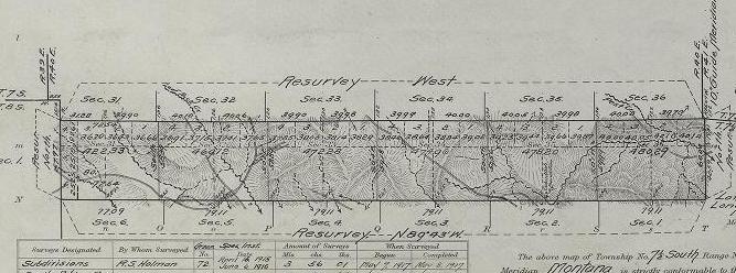
Here is a rare small township in Montana that is surrounded by townships in the same Principal Meridian

T7-1/2S R40E


Posted : February 19, 2011 6:00 pm

tyler-parsons
(@tyler-parsons)
Posts: 554
Member
Translate
English
Spanish
French
German
Italian
Portuguese
Russian
Chinese
Japanese
Korean
Arabic
Hindi
Dutch
Polish
Turkish
Vietnamese
Thai
Swedish
Danish
Finnish
Norwegian
Czech
Hungarian
Romanian
Greek
Hebrew
Indonesian
Malay
Ukrainian
Bulgarian
Croatian
Slovak
Slovenian
Serbian
Lithuanian
Latvian
Estonian
 

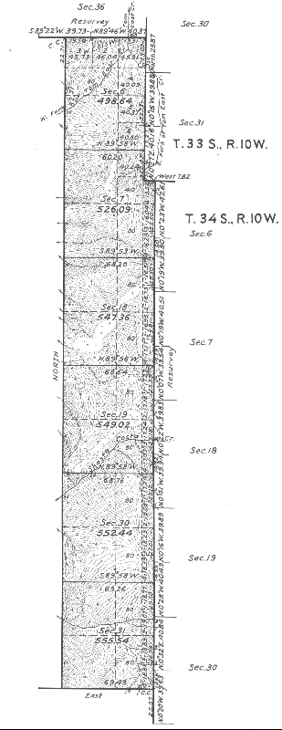
Another in Oregon: T34S R10-1/2W WM


Posted : February 19, 2011 6:08 pm
Kris Morgan
(@kris-morgan)
Posts: 3855
Member
Topic starter
Translate
English
Spanish
French
German
Italian
Portuguese
Russian
Chinese
Japanese
Korean
Arabic
Hindi
Dutch
Polish
Turkish
Vietnamese
Thai
Swedish
Danish
Finnish
Norwegian
Czech
Hungarian
Romanian
Greek
Hebrew
Indonesian
Malay
Ukrainian
Bulgarian
Croatian
Slovak
Slovenian
Serbian
Lithuanian
Latvian
Estonian
 

Jules

SE 1/4 of Sec. 13, T9S, R12 E of the New Mexico P.M?

Make sure you remember I'm in Texas and I've never surveyed a section ever.

🙂


Posted : February 19, 2011 6:29 pm
jules-j
(@jules-j)
Posts: 724
Member
Translate
English
Spanish
French
German
Italian
Portuguese
Russian
Chinese
Japanese
Korean
Arabic
Hindi
Dutch
Polish
Turkish
Vietnamese
Thai
Swedish
Danish
Finnish
Norwegian
Czech
Hungarian
Romanian
Greek
Hebrew
Indonesian
Malay
Ukrainian
Bulgarian
Croatian
Slovak
Slovenian
Serbian
Lithuanian
Latvian
Estonian
 

Jules

SE 1/4 of Sec. 13, T9S, R12 E of the New Mexico P.M


Posted : February 19, 2011 6:48 pm
MightyMoe
(@mightymoe)
Posts: 10534
Member
Translate
English
Spanish
French
German
Italian
Portuguese
Russian
Chinese
Japanese
Korean
Arabic
Hindi
Dutch
Polish
Turkish
Vietnamese
Thai
Swedish
Danish
Finnish
Norwegian
Czech
Hungarian
Romanian
Greek
Hebrew
Indonesian
Malay
Ukrainian
Bulgarian
Croatian
Slovak
Slovenian
Serbian
Lithuanian
Latvian
Estonian
 

Jules

Nice Section. You've got M.S. mixed with Lots. To be really picky I would never write a description for that area with SE1/4 in it. I would use the Lot# and the M.S.#. It looks like it would be a fun survey. The notes will tell a surveyor quite a bit for that area (or any area actually). And there will be blown up plats for the M.S, surveys. Your friend could probably use copies of all the plats for that area. I don't know how far the scanning process is in New Mexico, but from my experience that web site often is lacking many of the plats for a township. I would contact the BLM field office and order the Plats.


Posted : February 19, 2011 7:16 pm
jlwahl
(@jlwahl)
Posts: 204
Member
Translate
English
Spanish
French
German
Italian
Portuguese
Russian
Chinese
Japanese
Korean
Arabic
Hindi
Dutch
Polish
Turkish
Vietnamese
Thai
Swedish
Danish
Finnish
Norwegian
Czech
Hungarian
Romanian
Greek
Hebrew
Indonesian
Malay
Ukrainian
Bulgarian
Croatian
Slovak
Slovenian
Serbian
Lithuanian
Latvian
Estonian
 

My short answer is that it is actually pretty common.

I guess you would have to define common though.

It's the kind of thing that probably has thousands and thousands of occurances, when ever surveys coming from different origins come together, or close into other things like state boundaries, reservations, other surveys done earlier and extended from a distance, or a resolution for accumulated survey errors for several dozen reasons.

- jlw


Posted : February 19, 2011 8:42 pm

Pablo
(@pablo)
Posts: 444
Member
Translate
English
Spanish
French
German
Italian
Portuguese
Russian
Chinese
Japanese
Korean
Arabic
Hindi
Dutch
Polish
Turkish
Vietnamese
Thai
Swedish
Danish
Finnish
Norwegian
Czech
Hungarian
Romanian
Greek
Hebrew
Indonesian
Malay
Ukrainian
Bulgarian
Croatian
Slovak
Slovenian
Serbian
Lithuanian
Latvian
Estonian
 

Looks pretty common. The connection between the original surveys on each side of T9S R12E was not made until 1922 between original surveys circa 1880's. A 1/2 Township or Range is made when official surveys between previous original surveys were not actually connected thus leaving a gap between the two surveys and creating a gap thus 1/2 Twp's Rg's.

Pablo


Posted : February 19, 2011 9:17 pm
Keith
(@keith)
Posts: 2049
Member
Translate
English
Spanish
French
German
Italian
Portuguese
Russian
Chinese
Japanese
Korean
Arabic
Hindi
Dutch
Polish
Turkish
Vietnamese
Thai
Swedish
Danish
Finnish
Norwegian
Czech
Hungarian
Romanian
Greek
Hebrew
Indonesian
Malay
Ukrainian
Bulgarian
Croatian
Slovak
Slovenian
Serbian
Lithuanian
Latvian
Estonian
 

Pablo

And of course that is a real gap! Not like the ones that are created by the measurement experts on attempting to lay out a deed by the record.

Keith


Posted : February 19, 2011 10:43 pm
dave-karoly
(@dave-karoly)
Posts: 11990
Member
Translate
English
Spanish
French
German
Italian
Portuguese
Russian
Chinese
Japanese
Korean
Arabic
Hindi
Dutch
Polish
Turkish
Vietnamese
Thai
Swedish
Danish
Finnish
Norwegian
Czech
Hungarian
Romanian
Greek
Hebrew
Indonesian
Malay
Ukrainian
Bulgarian
Croatian
Slovak
Slovenian
Serbian
Lithuanian
Latvian
Estonian
 

Pablo

Jim McCavitt told us they are working a problem with a 1970s era dependent resurvey which involves two sets of monuments, I think on a Range line. He said the 1970s survey found one of the rows of monuments and understandably it didn't occur to anyone there could be another set of monuments lurking out there. A fire burned the brush down and well, heck, there's another set of monuments so apparently there is a physical gap between the two townships. It seems like he said one of the 19th century surveyors said he found the monuments but evidently didn't and set new ones.


Posted : February 20, 2011 7:01 pm
scotland
(@scotland)
Posts: 903
Member
Translate
English
Spanish
French
German
Italian
Portuguese
Russian
Chinese
Japanese
Korean
Arabic
Hindi
Dutch
Polish
Turkish
Vietnamese
Thai
Swedish
Danish
Finnish
Norwegian
Czech
Hungarian
Romanian
Greek
Hebrew
Indonesian
Malay
Ukrainian
Bulgarian
Croatian
Slovak
Slovenian
Serbian
Lithuanian
Latvian
Estonian
 

Looks like something went bad because the right side of that township is shown at a first auxillary meridian. Have to get the notes and follow up on that.


Posted : February 20, 2011 9:18 pm