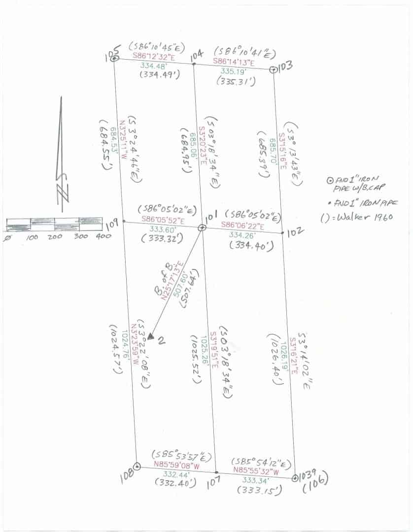
A lookout and radio repeater site on top of a mountain consists of four 5 acre aliquots (nominally 330' east-west by 660' north-south, the center quarter section corner is the common corner, plus two 2.5 acre aliquots (nominally 330x330) acquired from the railroad in 1935 (railroad grant). This is in Section 27.
Surveyor Charles O. Walker, LS2877, whom I have found to be a very good surveyor the few times I have followed him, surveyed Section 27 in 1956 and set monuments around the lookout property. Then in 1960 he surveyed it again, he determined some of the corners he used in 1956 were incorrect so he moved his monuments to the correct positions of the aliquot corners (we have the field notes). He found 3 section corners and one quarter section corner; he reeestablished the southeast corner of Section 27 by single proportion for easting and by GLO distance call to ravine northing. This is at least partially supported by California Supreme Court opinions which state approximate positions from topo calls is better than proportioning. He single proportioned the three missing quarter section corners.
There is National Forest lands touching some of the Section boundaries (but not our aliquots which is all surrounded by a private timber company, the successor in interest of the railroad). The BLM did a dependent resurvey of Section 27 (and others) in 1984 and accepted all of the corners of local control except Walker's southeast corner (and the quarter between 26 and 27 which is dependent on it) saying Walker used improper procedure. I don't agree with this; I believe Walker used the best evidence available to restore the corner. Nonetheless BLM double proportioned the southeast corner of Section 27 and re-single proportioned the east quarter section corner north of it. We don't have a direct beef with them over this because their Forest boundary does not touch our lookout site boundary.
Theoretically, this shoves our aliquots 42' north (and possible makes them slightly smaller). My opinion is that our corners were established and set by Walker using proper and reasonable procedure in 1960 (56 years ago) and they are the established corners of our property. There is a note in the file wherein one of my predecessors talked with the private timber company and they agreed the existing monuments are the corners and mark the boundaries. I have personally talked to Forestry company managers who say in a panicked voice, "you aren't going to move all those corners, are you?" referring to monuments set by my department over 50 years ago which have been in use as the boundaries ever since. Apparently surveyors don't have the best reputation in some circles.
If BLM thinks their boundary corner remote from our property is in a different place then more power to them but our monuments stay. They are all right where Walker said he set them, I mean amazingly close for the transit tape era in rough forest terrain; a couple of tenths per mile.
A few years ago I performed a survey for a family trust that involved the best part of a section. The section had originally been subdivided into 40 acre surplus allotment for Arapaho tribal members ownership. The estate had been built over a period of time by the now deceased patriarch by purchasing up a number of 10,20 and 40 acre tracts, all with aliquot descriptions. I think the property had almost twenty corners. Most of the 'government' corner were restored from the old County Surveyor's notes. This old man's notes are generally held as "gold" around these parts and perpetuated from as far back as the 1920s and a few even documented the original GLO corners. I did not consider any part of the boundary to be anything other than established.
About a year later the remainder of the section was collectively purchased and donated into a larger Federal Wildlife Sanctuary in concert with the Cheyenne Arapaho Tribe. A "dependent resurvey" was performed by the joint BIA/BLM office. For some "unknown reason" the resurvey corners did not jive with old man Holcomb's historic locations...lots of single and double proportion insanity going on.
To this day there are several corners between the two properties that have double corners, some with 12' to 15' differences. Some gores and some hiatuses. A phucked up mess. Most of us "private" surveyors that work in the area still hold with the historic locations out there.
Some of the BLM's pretty bronze monuments have disappeared, but I wouldn't know anything about that.
They do love to prorate
This case demonstrates the paradox of too much information. If a monument has existed for a long time and no one knows exactly its origin then it can safely be assumed it's a perpetuation of the original.
But if detailed information is available due to someone keeping good records then the monument can more readily be rejected due to improper procedure or other reasons.
I saw a Tesla the other day with the vanity plate PERADOX. Dan guessed the owners are a pair of doctors.
If you belive the radio repeater boundary is suppress by state law and there is no boundary in common with any federal interest there is no conflict with holding it.


