Reading RPLS is free for the whole profession. Members post, reply, and get the members-only rooms.

Notifications
Clear all

Topic starter
Translate
▼
English
Spanish
French
German
Italian
Portuguese
Russian
Chinese
Japanese
Korean
Arabic
Hindi
Dutch
Polish
Turkish
Vietnamese
Thai
Swedish
Danish
Finnish
Norwegian
Czech
Hungarian
Romanian
Greek
Hebrew
Indonesian
Malay
Ukrainian
Bulgarian
Croatian
Slovak
Slovenian
Serbian
Lithuanian
Latvian
Estonian
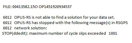
First time I have had this happen and it happened with two successive sessions, but everything was okay before and after. Both were in areas with very clear horizons. Both sessions were 20 minutes which is normally enough for me to get a good location to obtain a rapid-static position through OPUS and I have done it many times. The positions are used only to triangulate and locate nearby buried 1889 Missouri River Commission historical stones (18" square), so if I am within a few tenths that is sufficient. The problem is that these two points are about 350 miles away, so I cannot easily redo them. The hope was on my next trip to find the buried points using this data. I assume something was going on with the satellites? I was using a Sokkia GSR2700ISX receiver. If anyone thinks the data can be massaged to make it work I can send the raw PDC file or the Rinex created "O" file. I've tried resending the files multiple times and they won't get a solution.
Posted : January 4, 2016 9:58 am

Translate
▼
English
Spanish
French
German
Italian
Portuguese
Russian
Chinese
Japanese
Korean
Arabic
Hindi
Dutch
Polish
Turkish
Vietnamese
Thai
Swedish
Danish
Finnish
Norwegian
Czech
Hungarian
Romanian
Greek
Hebrew
Indonesian
Malay
Ukrainian
Bulgarian
Croatian
Slovak
Slovenian
Serbian
Lithuanian
Latvian
Estonian
J. Penry, post: 351591, member: 321 wrote: First time I have had this happen and it happened with two successive sessions, but everything was okay before and after. Both were in areas with very clear horizons. Both sessions were 20 minutes which is normally enough for me to get a good location to obtain a rapid-static position through OPUS and I have done it many times. The positions are used only to triangulate and locate nearby buried 1889 Missouri River Commission historical stones (18" square), so if I am within a few tenths that is sufficient. The problem is that these two points are about 350 miles away, so I cannot easily redo them. The hope was on my next trip to find the buried points using this data. I assume something was going on with the satellites? I was using a Sokkia GSR2700ISX receiver. If anyone thinks the data can be massaged to make it work I can send the raw PDC file or the Rinex created "O" file. I've tried resending the files multiple times and they won't get a solution.
I'd try to select your own CORS and see if that will help. Sometimes one is funky and can hurt the solution.
Posted : January 4, 2016 10:24 am
Topic starter
Translate
▼
English
Spanish
French
German
Italian
Portuguese
Russian
Chinese
Japanese
Korean
Arabic
Hindi
Dutch
Polish
Turkish
Vietnamese
Thai
Swedish
Danish
Finnish
Norwegian
Czech
Hungarian
Romanian
Greek
Hebrew
Indonesian
Malay
Ukrainian
Bulgarian
Croatian
Slovak
Slovenian
Serbian
Lithuanian
Latvian
Estonian
I've tried every combination of holding and deleting stations and nothing will process. Usually I set two points near the station I want to find and then do a distance/distance to find the buried point. Unfortunately, I am missing one solution each from two different sites.
Posted : January 4, 2016 10:51 am

Translate
▼
English
Spanish
French
German
Italian
Portuguese
Russian
Chinese
Japanese
Korean
Arabic
Hindi
Dutch
Polish
Turkish
Vietnamese
Thai
Swedish
Danish
Finnish
Norwegian
Czech
Hungarian
Romanian
Greek
Hebrew
Indonesian
Malay
Ukrainian
Bulgarian
Croatian
Slovak
Slovenian
Serbian
Lithuanian
Latvian
Estonian
J. Penry, post: 351591, member: 321 wrote: First time I have had this happen and it happened with two successive sessions, but everything was okay before and after. Both were in areas with very clear horizons. Both sessions were 20 minutes which is normally enough for me to get a good location to obtain a rapid-static position through OPUS and I have done it many times. The positions are used only to triangulate and locate nearby buried 1889 Missouri River Commission historical stones (18" square), so if I am within a few tenths that is sufficient. The problem is that these two points are about 350 miles away, so I cannot easily redo them. The hope was on my next trip to find the buried points using this data. I assume something was going on with the satellites? I was using a Sokkia GSR2700ISX receiver. If anyone thinks the data can be massaged to make it work I can send the raw PDC file or the Rinex created "O" file. I've tried resending the files multiple times and they won't get a solution.
Jerry,
Feel free to shoot me your .15o files, and I'll take a look at them.
LDOGEO at aol dot com
Loyal
Posted : January 4, 2016 11:22 am

Translate
▼
English
Spanish
French
German
Italian
Portuguese
Russian
Chinese
Japanese
Korean
Arabic
Hindi
Dutch
Polish
Turkish
Vietnamese
Thai
Swedish
Danish
Finnish
Norwegian
Czech
Hungarian
Romanian
Greek
Hebrew
Indonesian
Malay
Ukrainian
Bulgarian
Croatian
Slovak
Slovenian
Serbian
Lithuanian
Latvian
Estonian
Send me your obs files at ldrennan AT mphinc DOT com
Posted : January 4, 2016 4:44 pm

Translate
▼
English
Spanish
French
German
Italian
Portuguese
Russian
Chinese
Japanese
Korean
Arabic
Hindi
Dutch
Polish
Turkish
Vietnamese
Thai
Swedish
Danish
Finnish
Norwegian
Czech
Hungarian
Romanian
Greek
Hebrew
Indonesian
Malay
Ukrainian
Bulgarian
Croatian
Slovak
Slovenian
Serbian
Lithuanian
Latvian
Estonian
Jerry,
I sent you some useable coordinates.
As per the others, I did not see cycle slips. Of note is your two bad? files were in between 2 good? files. I would suggest you contact NGS and ask them to take a look at your submissions.
I also note that my OPUS-RS solution for chamberlain1 did not use SDPI CORS the nearest CORS to the North and that the NS position had large deviations. Using GPS Planning for your location the NS geometry was not too strong at your observation time.
Paul in PA
Posted : January 5, 2016 11:22 am
Topic starter
Translate
▼
English
Spanish
French
German
Italian
Portuguese
Russian
Chinese
Japanese
Korean
Arabic
Hindi
Dutch
Polish
Turkish
Vietnamese
Thai
Swedish
Danish
Finnish
Norwegian
Czech
Hungarian
Romanian
Greek
Hebrew
Indonesian
Malay
Ukrainian
Bulgarian
Croatian
Slovak
Slovenian
Serbian
Lithuanian
Latvian
Estonian
Many thanks to D. Ingram, Lee D., Loyal, and Paul in PA for assisting me in coming up with a position for these two points. While the positions do not agree exactly, they all agree within a very small radius which will help me accomplish my future goal. The knowledge and willingness to help from people here is outstanding! :stakeout:
Posted : January 5, 2016 2:30 pm