AI Assistant
Notifications
Clear all

How many state corners have you visited?

21 Posts
17 Users
0 Reactions
727 Views
Dave Ingram
(@dave-ingram)
Posts: 2140
Member
Topic starter
Translate
English
Spanish
French
German
Italian
Portuguese
Russian
Chinese
Japanese
Korean
Arabic
Hindi
Dutch
Polish
Turkish
Vietnamese
Thai
Swedish
Danish
Finnish
Norwegian
Czech
Hungarian
Romanian
Greek
Hebrew
Indonesian
Malay
Ukrainian
Bulgarian
Croatian
Slovak
Slovenian
Serbian
Lithuanian
Latvian
Estonian
 

Now I'm not talking about meanders along rivers or things like Mason-Dixon stones along the MD/PA boundary, but actual corners where 2 or more states come together.

In my case - 4 -- MD/WV, MD/WV/PA, CO/KS/OK, CO/NE/KS


Posted : August 18, 2013 10:29 am
Bob Westerman
(@bobwesterman)
Posts: 259
Member
Translate
English
Spanish
French
German
Italian
Portuguese
Russian
Chinese
Japanese
Korean
Arabic
Hindi
Dutch
Polish
Turkish
Vietnamese
Thai
Swedish
Danish
Finnish
Norwegian
Czech
Hungarian
Romanian
Greek
Hebrew
Indonesian
Malay
Ukrainian
Bulgarian
Croatian
Slovak
Slovenian
Serbian
Lithuanian
Latvian
Estonian
 

Just one, PA/WV


Posted : August 18, 2013 10:56 am
holy-cow
(@holy-cow)
Posts: 25672
Member
Translate
English
Spanish
French
German
Italian
Portuguese
Russian
Chinese
Japanese
Korean
Arabic
Hindi
Dutch
Polish
Turkish
Vietnamese
Thai
Swedish
Danish
Finnish
Norwegian
Czech
Hungarian
Romanian
Greek
Hebrew
Indonesian
Malay
Ukrainian
Bulgarian
Croatian
Slovak
Slovenian
Serbian
Lithuanian
Latvian
Estonian
 

At least seven, to be directly at the marker. Another, I could see the corner, but didn't go over to it. (KS/MO/OK) And, another, I was as close as you can get by road, but wasn't going to trespass over two miles across swampy river bottom and then swim out to the middle of the river. (KS/NE/MO)

I didn't count the four corners marker of UT/CO/AZ/NM as I was only three and don't really remember anything about it.

Probably got as close as reasonable to another, but, I'm not sure just how far out into Lake Michigan the Michigan-Indiana line runs. Same is true of the Illinois-Wisconsin line and Lake Michigan.

The seven where I have been and circled the actual marker are:

Where the northeast corner of Colorado borders only Nebraska.
The NE/KS/CO corner.
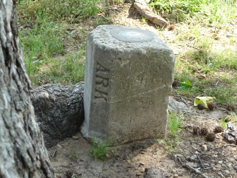
The KS/OK/CO corner featured in the thread below.
The OK/NM/CO corner
Where the northwest corner of the Texas Panhandle borders only New Mexico
The OK/NM/TX corner about two miles further east.
Where the northeast corner of the Texas Panhandle borders only Oklahoma.


Posted : August 18, 2013 11:00 am
paden-cash
(@paden-cash)
Posts: 11086
Member
Translate
English
Spanish
French
German
Italian
Portuguese
Russian
Chinese
Japanese
Korean
Arabic
Hindi
Dutch
Polish
Turkish
Vietnamese
Thai
Swedish
Danish
Finnish
Norwegian
Czech
Hungarian
Romanian
Greek
Hebrew
Indonesian
Malay
Ukrainian
Bulgarian
Croatian
Slovak
Slovenian
Serbian
Lithuanian
Latvian
Estonian
 

I've been here:

The photo BTW is courtesy Lee Schroeder.

As to whether or not it is really the State boundary, you would have to check the Supreme Court's Records:

Texas and Oklahoma Boundaries have been surveyed to death. If you have trouble sleeping, try to read this interesting publication:

Texas Boundary Report

I've also been to the I.P. of the Cimarron Meridian, but I believe it is not technically a State Boundary "Corner".


Posted : August 18, 2013 11:28 am
paul-in-pa
(@paul-in-pa)
Posts: 6034
Member
Translate
English
Spanish
French
German
Italian
Portuguese
Russian
Chinese
Japanese
Korean
Arabic
Hindi
Dutch
Polish
Turkish
Vietnamese
Thai
Swedish
Danish
Finnish
Norwegian
Czech
Hungarian
Romanian
Greek
Hebrew
Indonesian
Malay
Ukrainian
Bulgarian
Croatian
Slovak
Slovenian
Serbian
Lithuanian
Latvian
Estonian
 

Why Would They Have To Repurchase The Land From Texas ?

Until the Supreme Court ruled the land was in OK.

The land was purchased in good faith. Absent fraud by OK the only status that should have changed after the ruling was the County and State. Ownership should not have changed.

Paul in PA


Posted : August 18, 2013 12:23 pm

holy-cow
(@holy-cow)
Posts: 25672
Member
Translate
English
Spanish
French
German
Italian
Portuguese
Russian
Chinese
Japanese
Korean
Arabic
Hindi
Dutch
Polish
Turkish
Vietnamese
Thai
Swedish
Danish
Finnish
Norwegian
Czech
Hungarian
Romanian
Greek
Hebrew
Indonesian
Malay
Ukrainian
Bulgarian
Croatian
Slovak
Slovenian
Serbian
Lithuanian
Latvian
Estonian
 

Texhoma, OK and Texhoma, TX

The difference between the baseline and the current TX/OK line is easy to see by looking at a view of the two Texhoma's. This is a little west of the center of then north line of the Texas Panhandle where US54 slices through. The difference is a bit more than one block. That little sliver along the south side of Texhoma, OK is in Section 5 while the rest of the OK side is in Section 32. The north-south dimension of the section is only a few hundred feet.

Over 25 years ago I met a fellow who had spent most of his life in that area. He owned a machine shop there. He said when it was built it was in one State, but, when he bought it, it was in another State.


Posted : August 18, 2013 12:28 pm
rich-leu
(@rich-leu)
Posts: 850
Member
Translate
English
Spanish
French
German
Italian
Portuguese
Russian
Chinese
Japanese
Korean
Arabic
Hindi
Dutch
Polish
Turkish
Vietnamese
Thai
Swedish
Danish
Finnish
Norwegian
Czech
Hungarian
Romanian
Greek
Hebrew
Indonesian
Malay
Ukrainian
Bulgarian
Croatian
Slovak
Slovenian
Serbian
Lithuanian
Latvian
Estonian
 

Dave...

What about this one? I know you were there. I saw you.


Posted : August 18, 2013 12:39 pm
Dave Ingram
(@dave-ingram)
Posts: 2140
Member
Topic starter
Translate
English
Spanish
French
German
Italian
Portuguese
Russian
Chinese
Japanese
Korean
Arabic
Hindi
Dutch
Polish
Turkish
Vietnamese
Thai
Swedish
Danish
Finnish
Norwegian
Czech
Hungarian
Romanian
Greek
Hebrew
Indonesian
Malay
Ukrainian
Bulgarian
Croatian
Slovak
Slovenian
Serbian
Lithuanian
Latvian
Estonian
 

Dave...

Plumb forgot about that one.


Posted : August 18, 2013 12:41 pm
Scott McLain
(@scott-mclain)
Posts: 782
Member
Translate
English
Spanish
French
German
Italian
Portuguese
Russian
Chinese
Japanese
Korean
Arabic
Hindi
Dutch
Polish
Turkish
Vietnamese
Thai
Swedish
Danish
Finnish
Norwegian
Czech
Hungarian
Romanian
Greek
Hebrew
Indonesian
Malay
Ukrainian
Bulgarian
Croatian
Slovak
Slovenian
Serbian
Lithuanian
Latvian
Estonian
 

This must be the most famous one.

Was a different monument last time I was there. About 1972. Stood in one state, holding hands with two brothers and a sister. All in different states of coarse.
Thanks for jogging the memories out. Good times.


Posted : August 18, 2013 1:11 pm
holy-cow
(@holy-cow)
Posts: 25672
Member
Translate
English
Spanish
French
German
Italian
Portuguese
Russian
Chinese
Japanese
Korean
Arabic
Hindi
Dutch
Polish
Turkish
Vietnamese
Thai
Swedish
Danish
Finnish
Norwegian
Czech
Hungarian
Romanian
Greek
Hebrew
Indonesian
Malay
Ukrainian
Bulgarian
Croatian
Slovak
Slovenian
Serbian
Lithuanian
Latvian
Estonian
 

Here's a potentially expensive one to visit

The east-west gray line in the photo below is the Kansas/Oklahoma border. The north-south gray line at the right is the west line of Missouri as it borders both States. The junction therefore is the KS/MO/OK corner. The road shown going to it doesn't actually go quite that far, as far as vehicle accessibility is concerned. The City of Joplin, Missouri is located a very short distance to the east and northeast of this corner.

The western half of the pic shows Downsteam Casino, which is owned by the Quapaw Indian Tribe. Note that all the gambling, etc. is located in Oklahoma and the vast majority of the parking lot is located in Kansas. That is because the ability to get approved by the Great White Fathers in Topeka is much, much difficult than it is in Oklahoma City. Former Oklahoma University football coach, Barry Switzer and a host of famous collegiate/pro footballer's are featured in the TV commercials promoting a Las Vegas-like atmosphere. Golfer John Daley is another celebrity spokesman, usually seen harassing Switzer.


Posted : August 18, 2013 1:45 pm

jaro
 jaro
(@jaro)
Posts: 1722
Member
Translate
English
Spanish
French
German
Italian
Portuguese
Russian
Chinese
Japanese
Korean
Arabic
Hindi
Dutch
Polish
Turkish
Vietnamese
Thai
Swedish
Danish
Finnish
Norwegian
Czech
Hungarian
Romanian
Greek
Hebrew
Indonesian
Malay
Ukrainian
Bulgarian
Croatian
Slovak
Slovenian
Serbian
Lithuanian
Latvian
Estonian
 

The four corners marker, NM, CO, UT, and AZ in 1987 and the corner of Virginia and Kentucky on the north Tennessee line in 1980.

James


Posted : August 18, 2013 2:11 pm
RADAR
(@dougie)
Posts: 7880
Member
Translate
English
Spanish
French
German
Italian
Portuguese
Russian
Chinese
Japanese
Korean
Arabic
Hindi
Dutch
Polish
Turkish
Vietnamese
Thai
Swedish
Danish
Finnish
Norwegian
Czech
Hungarian
Romanian
Greek
Hebrew
Indonesian
Malay
Ukrainian
Bulgarian
Croatian
Slovak
Slovenian
Serbian
Lithuanian
Latvian
Estonian
 

To bad the marker is in the wrong spot.....;-)

Miles away from the true intersection


Posted : August 18, 2013 3:42 pm
base9geodesy
(@base9geodesy)
Posts: 254
Member
Translate
English
Spanish
French
German
Italian
Portuguese
Russian
Chinese
Japanese
Korean
Arabic
Hindi
Dutch
Polish
Turkish
Vietnamese
Thai
Swedish
Danish
Finnish
Norwegian
Czech
Hungarian
Romanian
Greek
Hebrew
Indonesian
Malay
Ukrainian
Bulgarian
Croatian
Slovak
Slovenian
Serbian
Lithuanian
Latvian
Estonian
 

I had to think about this one. I get 9, MD/DE, MD/DE/PA, NJ/NY/PA, VA/NC, LA/AR/TX, AZ/CO/NV/UT, CO/NE/WY, CO/NE/KS and CA/OR/NV


Posted : August 18, 2013 6:38 pm
Perry Williams
(@perry-williams)
Posts: 2183
Member
Translate
English
Spanish
French
German
Italian
Portuguese
Russian
Chinese
Japanese
Korean
Arabic
Hindi
Dutch
Polish
Turkish
Vietnamese
Thai
Swedish
Danish
Finnish
Norwegian
Czech
Hungarian
Romanian
Greek
Hebrew
Indonesian
Malay
Ukrainian
Bulgarian
Croatian
Slovak
Slovenian
Serbian
Lithuanian
Latvian
Estonian
 

State HIghpoints

no corners but highpoints of:

NH, VT, ME, NY, MI, MN, WI, IA, NE, CO, TX & SD


Posted : August 18, 2013 7:38 pm
Doug Crawford
(@doug-crawford)
Posts: 681
Member
Translate
English
Spanish
French
German
Italian
Portuguese
Russian
Chinese
Japanese
Korean
Arabic
Hindi
Dutch
Polish
Turkish
Vietnamese
Thai
Swedish
Danish
Finnish
Norwegian
Czech
Hungarian
Romanian
Greek
Hebrew
Indonesian
Malay
Ukrainian
Bulgarian
Croatian
Slovak
Slovenian
Serbian
Lithuanian
Latvian
Estonian
 

State HIghpoints

Likewise, no corners, but made it here.


Posted : August 18, 2013 8:02 pm

Kris Morgan
(@kris-morgan)
Posts: 3855
Member
Translate
English
Spanish
French
German
Italian
Portuguese
Russian
Chinese
Japanese
Korean
Arabic
Hindi
Dutch
Polish
Turkish
Vietnamese
Thai
Swedish
Danish
Finnish
Norwegian
Czech
Hungarian
Romanian
Greek
Hebrew
Indonesian
Malay
Ukrainian
Bulgarian
Croatian
Slovak
Slovenian
Serbian
Lithuanian
Latvian
Estonian
 

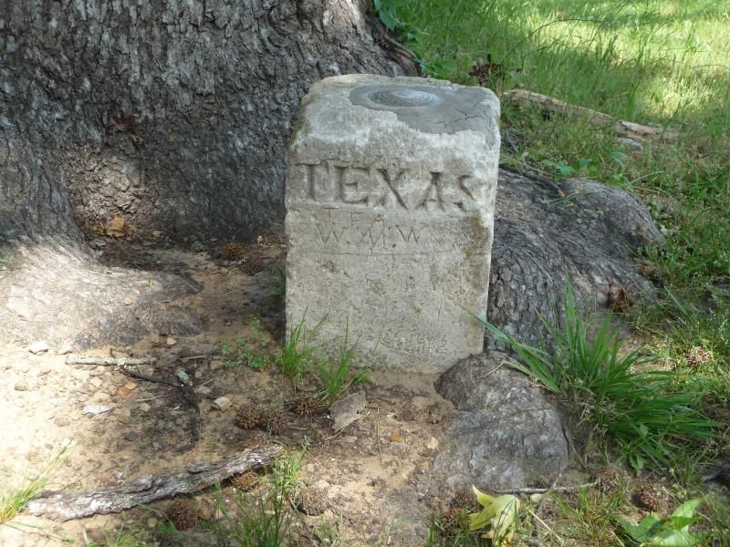
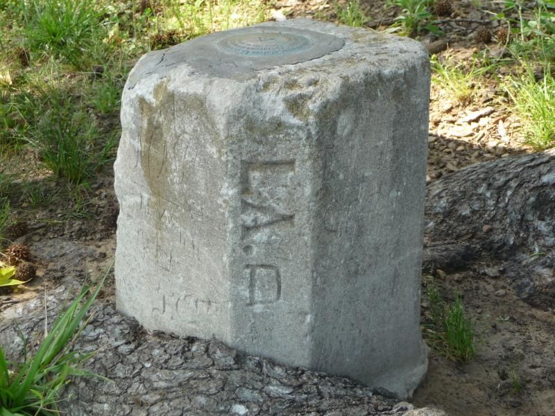
I have been to the common corner between Texas and Louisiana where the East line intersects the Sabine River and runs downstream to the Gulf. To the North of the corner, two miles, I found, what is purported to be, the only International Boundary Marker left within the lower 48 when the Republic of Texas was not part of the Union.


Posted : August 19, 2013 6:54 am
paul-in-pa
(@paul-in-pa)
Posts: 6034
Member
Translate
English
Spanish
French
German
Italian
Portuguese
Russian
Chinese
Japanese
Korean
Arabic
Hindi
Dutch
Polish
Turkish
Vietnamese
Thai
Swedish
Danish
Finnish
Norwegian
Czech
Hungarian
Romanian
Greek
Hebrew
Indonesian
Malay
Ukrainian
Bulgarian
Croatian
Slovak
Slovenian
Serbian
Lithuanian
Latvian
Estonian
 

Highpoint, New Jersey

Easy to get to, just a few miles off I-84 at Port Jervis, NY.

From Highpoint you can look down on the NJ-NY-PA corner in the middle of the Delaware, which I have canoed over quite a few times.

Numerous times we have driven on the highest point on I-80 East of the Mississippi but I never considered the high point of PA. Which I'll have to Google now.

Paul in PA


Posted : August 19, 2013 6:56 am
j-penry
(@j-penry)
Posts: 1396
Member
Translate
English
Spanish
French
German
Italian
Portuguese
Russian
Chinese
Japanese
Korean
Arabic
Hindi
Dutch
Polish
Turkish
Vietnamese
Thai
Swedish
Danish
Finnish
Norwegian
Czech
Hungarian
Romanian
Greek
Hebrew
Indonesian
Malay
Ukrainian
Bulgarian
Croatian
Slovak
Slovenian
Serbian
Lithuanian
Latvian
Estonian
 

Nebraska's Six State Corners

http://www.penryfamily.com/surveying/statecorners.html


Posted : August 19, 2013 7:45 am
stephen-johnson
(@stephen-johnson)
Posts: 2326
Member
Translate
English
Spanish
French
German
Italian
Portuguese
Russian
Chinese
Japanese
Korean
Arabic
Hindi
Dutch
Polish
Turkish
Vietnamese
Thai
Swedish
Danish
Finnish
Norwegian
Czech
Hungarian
Romanian
Greek
Hebrew
Indonesian
Malay
Ukrainian
Bulgarian
Croatian
Slovak
Slovenian
Serbian
Lithuanian
Latvian
Estonian
 

> To bad the marker is in the wrong spot.....;-)
>
> Miles away from the true intersection

So they missed the called for geographical coordinates, it is still exactly where the original party set it.:-P


Posted : August 19, 2013 9:36 am
DeletedUser
(@deleted-user)
Posts: 8340
Member
Translate
English
Spanish
French
German
Italian
Portuguese
Russian
Chinese
Japanese
Korean
Arabic
Hindi
Dutch
Polish
Turkish
Vietnamese
Thai
Swedish
Danish
Finnish
Norwegian
Czech
Hungarian
Romanian
Greek
Hebrew
Indonesian
Malay
Ukrainian
Bulgarian
Croatian
Slovak
Slovenian
Serbian
Lithuanian
Latvian
Estonian
 

State HIghpoints

been to AR, NJ and AL high points..
no corners


Posted : August 19, 2013 12:20 pm

Page 1 / 2