AI Assistant
Notifications
Clear all

GEOID12 errors found in Louisiana and Mississipp

26 Posts
16 Users
0 Reactions
876 Views
geeoddmike
(@geeoddmike)
Posts: 1556
Member
Topic starter
Translate
English
Spanish
French
German
Italian
Portuguese
Russian
Chinese
Japanese
Korean
Arabic
Hindi
Dutch
Polish
Turkish
Vietnamese
Thai
Swedish
Danish
Finnish
Norwegian
Czech
Hungarian
Romanian
Greek
Hebrew
Indonesian
Malay
Ukrainian
Bulgarian
Croatian
Slovak
Slovenian
Serbian
Lithuanian
Latvian
Estonian
 

Howdy,

See the linked page for details about GEOID12 errors found in Louisiana and Mississippi.

http://www.ngs.noaa.gov/web/news/GEOID12_Error_Notice.shtml

Looks like big 30cm problems. From the linked page:

The National Geodetic Survey (NGS) has determined that the new hybrid geoid model, GEOID12, contains localized errors in Louisiana and Mississippi. The Louisiana area is centered in Alexandria and covers a roughly circular area about 160 km (100 miles) across. The Mississippi area is centered about 30 km (20 mi) south of Meridian and is about 60 km (35 mi) across.

See the page for map and more details.

Cheers,

DMM


Posted : August 5, 2012 8:59 pm
jhframe
(@jim-frame)
Posts: 7465
Member
Translate
English
Spanish
French
German
Italian
Portuguese
Russian
Chinese
Japanese
Korean
Arabic
Hindi
Dutch
Polish
Turkish
Vietnamese
Thai
Swedish
Danish
Finnish
Norwegian
Czech
Hungarian
Romanian
Greek
Hebrew
Indonesian
Malay
Ukrainian
Bulgarian
Croatian
Slovak
Slovenian
Serbian
Lithuanian
Latvian
Estonian
 

Oops!


Posted : August 5, 2012 9:11 pm
Kent McMillan
(@kent-mcmillan)
Posts: 11416
Member
Translate
English
Spanish
French
German
Italian
Portuguese
Russian
Chinese
Japanese
Korean
Arabic
Hindi
Dutch
Polish
Turkish
Vietnamese
Thai
Swedish
Danish
Finnish
Norwegian
Czech
Hungarian
Romanian
Greek
Hebrew
Indonesian
Malay
Ukrainian
Bulgarian
Croatian
Slovak
Slovenian
Serbian
Lithuanian
Latvian
Estonian
 

Louisiana and Mississippi errors found in GEOID12

> The National Geodetic Survey (NGS) has determined that the new hybrid geoid model, GEOID12, contains localized errors in Louisiana and Mississippi.

Probably the better statement would be "Louisiana and Mississippi have been found incompatible with GEOID12 at the 30cm level." This is big news?


Posted : August 6, 2012 12:10 am
Frank Willis
(@frank-willis)
Posts: 798
Member
Translate
English
Spanish
French
German
Italian
Portuguese
Russian
Chinese
Japanese
Korean
Arabic
Hindi
Dutch
Polish
Turkish
Vietnamese
Thai
Swedish
Danish
Finnish
Norwegian
Czech
Hungarian
Romanian
Greek
Hebrew
Indonesian
Malay
Ukrainian
Bulgarian
Croatian
Slovak
Slovenian
Serbian
Lithuanian
Latvian
Estonian
 

Louisiana and Mississippi errors found in GEOID12

I am hearing of errors in excess of 1 foot in north Louisiana. 09 was good, but 12 terrible.


Posted : August 6, 2012 7:22 am
Daniel S. McCabe
(@daniel-s-mccabe)
Posts: 1455
Member
Translate
English
Spanish
French
German
Italian
Portuguese
Russian
Chinese
Japanese
Korean
Arabic
Hindi
Dutch
Polish
Turkish
Vietnamese
Thai
Swedish
Danish
Finnish
Norwegian
Czech
Hungarian
Romanian
Greek
Hebrew
Indonesian
Malay
Ukrainian
Bulgarian
Croatian
Slovak
Slovenian
Serbian
Lithuanian
Latvian
Estonian
 

Oh joy.


Posted : August 6, 2012 9:00 am

alan-chavers
(@alan-chavers)
Posts: 257
Member
Translate
English
Spanish
French
German
Italian
Portuguese
Russian
Chinese
Japanese
Korean
Arabic
Hindi
Dutch
Polish
Turkish
Vietnamese
Thai
Swedish
Danish
Finnish
Norwegian
Czech
Hungarian
Romanian
Greek
Hebrew
Indonesian
Malay
Ukrainian
Bulgarian
Croatian
Slovak
Slovenian
Serbian
Lithuanian
Latvian
Estonian
 

I ran some sessions through both reference frames right before the mandatory change. The difference was 0.44'- quite a bit more than I was expecting. I bet there are problems here also.


Posted : August 6, 2012 9:07 am
Goddsc
(@goddsc)
Posts: 87
Member
Translate
English
Spanish
French
German
Italian
Portuguese
Russian
Chinese
Japanese
Korean
Arabic
Hindi
Dutch
Polish
Turkish
Vietnamese
Thai
Swedish
Danish
Finnish
Norwegian
Czech
Hungarian
Romanian
Greek
Hebrew
Indonesian
Malay
Ukrainian
Bulgarian
Croatian
Slovak
Slovenian
Serbian
Lithuanian
Latvian
Estonian
 

Alan,

Where are you located?

Thanks.


Posted : August 6, 2012 9:09 am
DeletedUser
(@deleted-user)
Posts: 8340
Member
Translate
English
Spanish
French
German
Italian
Portuguese
Russian
Chinese
Japanese
Korean
Arabic
Hindi
Dutch
Polish
Turkish
Vietnamese
Thai
Swedish
Danish
Finnish
Norwegian
Czech
Hungarian
Romanian
Greek
Hebrew
Indonesian
Malay
Ukrainian
Bulgarian
Croatian
Slovak
Slovenian
Serbian
Lithuanian
Latvian
Estonian
 

strange that it is so close to 1 foot. That could screw a lot of people up.


Posted : August 6, 2012 9:33 am
alan-chavers
(@alan-chavers)
Posts: 257
Member
Translate
English
Spanish
French
German
Italian
Portuguese
Russian
Chinese
Japanese
Korean
Arabic
Hindi
Dutch
Polish
Turkish
Vietnamese
Thai
Swedish
Danish
Finnish
Norwegian
Czech
Hungarian
Romanian
Greek
Hebrew
Indonesian
Malay
Ukrainian
Bulgarian
Croatian
Slovak
Slovenian
Serbian
Lithuanian
Latvian
Estonian
 

I'm sorry, "pay no attention to that man behind the curtain". What I looked at was the new reference system that is coming. Then, a month or so later someone mentions a difference in the two geoids and my old brain makes a false connection causing me to post something stupid. It was hundredths from '09 to '12. It's what is coming that will be significantly different. Below is what I misremembered.

** Orthometric Heights Above Future Geopotential Datum.

Prototype orthometric heights are now being made available as a precursor to the completion
of GRAV-D and the replacement of NAVD 88 with a new geopotential reference system. The
following height reflects the current best estimate of the true orthometric height, based on
the existing gravimetric geoid model. This height is subject to change as data and modeling
for the gravimetric geoid change throughout the lifetime of the GRAV-D project, or as new
realizations of the ITRF are adopted. However, at the completion of GRAV-D, these heights will
supersede the NAVD 88 heights

APPROX ORTHO HGT: 44.838 (m) [PROTOTYPE (Computed using USGG2009,GRS80,ITRF2000)]


Posted : August 6, 2012 9:42 am
Scott Wallace
(@scott-wallace)
Posts: 9
Member
Translate
English
Spanish
French
German
Italian
Portuguese
Russian
Chinese
Japanese
Korean
Arabic
Hindi
Dutch
Polish
Turkish
Vietnamese
Thai
Swedish
Danish
Finnish
Norwegian
Czech
Hungarian
Romanian
Greek
Hebrew
Indonesian
Malay
Ukrainian
Bulgarian
Croatian
Slovak
Slovenian
Serbian
Lithuanian
Latvian
Estonian
 

It seems like this problem could have been caught early on had someone written a simple test program to compare Geoid09 results against Geoid12 results (at one second intervals (lat/lon)). Any delta greater than X cm (say 5-15?) could have been flagged as a possible problem. This should be standard procedure going forward. These people are brilliant, but some of the mundane work must not be getting done. They should hire someone for just this purpose - unit testing of all software and data repositories.


Posted : August 6, 2012 10:47 am

Frank Willis
(@frank-willis)
Posts: 798
Member
Translate
English
Spanish
French
German
Italian
Portuguese
Russian
Chinese
Japanese
Korean
Arabic
Hindi
Dutch
Polish
Turkish
Vietnamese
Thai
Swedish
Danish
Finnish
Norwegian
Czech
Hungarian
Romanian
Greek
Hebrew
Indonesian
Malay
Ukrainian
Bulgarian
Croatian
Slovak
Slovenian
Serbian
Lithuanian
Latvian
Estonian
 

Scott, I absolutely, totally agree with your comment. This is really something.


Posted : August 6, 2012 2:05 pm
Cliff Mugnier
(@cliff-mugnier)
Posts: 1220
Member
Translate
English
Spanish
French
German
Italian
Portuguese
Russian
Chinese
Japanese
Korean
Arabic
Hindi
Dutch
Polish
Turkish
Vietnamese
Thai
Swedish
Danish
Finnish
Norwegian
Czech
Hungarian
Romanian
Greek
Hebrew
Indonesian
Malay
Ukrainian
Bulgarian
Croatian
Slovak
Slovenian
Serbian
Lithuanian
Latvian
Estonian
 

http://bit.ly/RRUjx4


Posted : August 6, 2012 9:03 pm
geeoddmike
(@geeoddmike)
Posts: 1556
Member
Topic starter
Translate
English
Spanish
French
German
Italian
Portuguese
Russian
Chinese
Japanese
Korean
Arabic
Hindi
Dutch
Polish
Turkish
Vietnamese
Thai
Swedish
Danish
Finnish
Norwegian
Czech
Hungarian
Romanian
Greek
Hebrew
Indonesian
Malay
Ukrainian
Bulgarian
Croatian
Slovak
Slovenian
Serbian
Lithuanian
Latvian
Estonian
 

Howdy,

For what it's worth, I took a look at the data related to LA and thought those following the issue might find the following links to be of interest.

The first link is to a map showing the differences between the two most recent hybrid geoid models.

http://www.openheatmap.com/view.html?map=CochairpersonsMistrystedEurodollar - Map showing differences between Geoid2009 and Geoid2012

The next link is to the GPS on BM data used for the hybrid geoid model. By my count ONLY 194 points in Louisiana are used; of this number 124 are labeled VTDP. Looks to me that there is not enough good data to create the hybrid model from the gravimetric. Not being an expert on the VTDP model, I am unable to assess its accuracy. That said, I do not see how vertical modeling given its non-linear nature and the sparsity and "unrepresentativeness" of the area modeled can be expected to work. In other words, if the only points available for modeling are along roadways and railroads how can they capture the vertical deformation over large areas without data points? Perhaps someone more familiar with VTDP can correct me.

One other observation about this data set is the fact that unlike states with a NGS Advisor, there are only two points specified as "Not to be used" in this data set. Looking at states with Advisors we see that they provided input into the BM selection process.

http://www.ngs.noaa.gov/GEOID/GEOID12/GPSonBM12.shtml - GPS on BM data set used for GEOID 2012

The next link is to a graphic showing the contour map of the hybrid geoid model over the Continental US. Note the "bubble" at Shreveport (oops meant Alexandria).

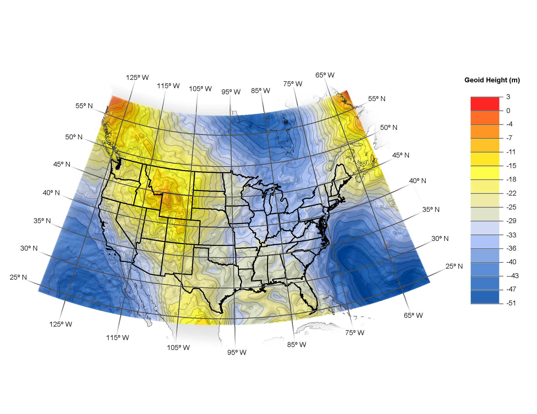
- graphic showing GEOID 2012

Finally compare the structure of the geoid in the gravimetric model. The bubble does not appear.

- graphic showing USGG 2012

Given the problem inherit in "correcting" the gravimetric model to fit the NAVD88 height network (which is not well monitored to say the least), any hybrid geoid model should be used with care. The obvious advantage of using GPS ellipsoid heights with the hybrid geoid model to generate NAVD 88 compatible heights should not blind us to the problems with the underlying data.


Posted : August 6, 2012 9:06 pm
Norman_Oklahoma
(@norman-oklahoma)
Posts: 8310
Member
Translate
English
Spanish
French
German
Italian
Portuguese
Russian
Chinese
Japanese
Korean
Arabic
Hindi
Dutch
Polish
Turkish
Vietnamese
Thai
Swedish
Danish
Finnish
Norwegian
Czech
Hungarian
Romanian
Greek
Hebrew
Indonesian
Malay
Ukrainian
Bulgarian
Croatian
Slovak
Slovenian
Serbian
Lithuanian
Latvian
Estonian
 

No legend on that map. I presume the bright white and dark spots represent areas of separation between the 2 models?


Posted : August 6, 2012 9:44 pm
Norman_Oklahoma
(@norman-oklahoma)
Posts: 8310
Member
Translate
English
Spanish
French
German
Italian
Portuguese
Russian
Chinese
Japanese
Korean
Arabic
Hindi
Dutch
Polish
Turkish
Vietnamese
Thai
Swedish
Danish
Finnish
Norwegian
Czech
Hungarian
Romanian
Greek
Hebrew
Indonesian
Malay
Ukrainian
Bulgarian
Croatian
Slovak
Slovenian
Serbian
Lithuanian
Latvian
Estonian
 

> It seems like this problem could have been caught early on had someone written a simple test program ....
I agree, but remember that the model was released months after it was promised. I bet there is a back story to this.


Posted : August 6, 2012 9:46 pm

Frank Willis
(@frank-willis)
Posts: 798
Member
Translate
English
Spanish
French
German
Italian
Portuguese
Russian
Chinese
Japanese
Korean
Arabic
Hindi
Dutch
Polish
Turkish
Vietnamese
Thai
Swedish
Danish
Finnish
Norwegian
Czech
Hungarian
Romanian
Greek
Hebrew
Indonesian
Malay
Ukrainian
Bulgarian
Croatian
Slovak
Slovenian
Serbian
Lithuanian
Latvian
Estonian
 

Worse than a bad altimeter in an airplane. Would rather not even have it.


Posted : August 7, 2012 5:38 am
Norman_Oklahoma
(@norman-oklahoma)
Posts: 8310
Member
Translate
English
Spanish
French
German
Italian
Portuguese
Russian
Chinese
Japanese
Korean
Arabic
Hindi
Dutch
Polish
Turkish
Vietnamese
Thai
Swedish
Danish
Finnish
Norwegian
Czech
Hungarian
Romanian
Greek
Hebrew
Indonesian
Malay
Ukrainian
Bulgarian
Croatian
Slovak
Slovenian
Serbian
Lithuanian
Latvian
Estonian
 

I wonder if OPUS will reopen access to Geoid09. Users in the affected areas are in a tough spot without it.

And I'm left wondering if problems in other areas will emerge.


Posted : August 7, 2012 8:06 am
Frank Willis
(@frank-willis)
Posts: 798
Member
Translate
English
Spanish
French
German
Italian
Portuguese
Russian
Chinese
Japanese
Korean
Arabic
Hindi
Dutch
Polish
Turkish
Vietnamese
Thai
Swedish
Danish
Finnish
Norwegian
Czech
Hungarian
Romanian
Greek
Hebrew
Indonesian
Malay
Ukrainian
Bulgarian
Croatian
Slovak
Slovenian
Serbian
Lithuanian
Latvian
Estonian
 

no kidding. I forgot about opus being messed up by this.


Posted : August 7, 2012 4:50 pm
DaveD
(@daved)
Posts: 50
Member
Translate
English
Spanish
French
German
Italian
Portuguese
Russian
Chinese
Japanese
Korean
Arabic
Hindi
Dutch
Polish
Turkish
Vietnamese
Thai
Swedish
Danish
Finnish
Norwegian
Czech
Hungarian
Romanian
Greek
Hebrew
Indonesian
Malay
Ukrainian
Bulgarian
Croatian
Slovak
Slovenian
Serbian
Lithuanian
Latvian
Estonian
 

Hire someone - what a great idea. Wouldn't that be nice. Everyone wants smaller government - here it is.


Posted : August 8, 2012 8:07 am
geeoddmike
(@geeoddmike)
Posts: 1556
Member
Topic starter
Translate
English
Spanish
French
German
Italian
Portuguese
Russian
Chinese
Japanese
Korean
Arabic
Hindi
Dutch
Polish
Turkish
Vietnamese
Thai
Swedish
Danish
Finnish
Norwegian
Czech
Hungarian
Romanian
Greek
Hebrew
Indonesian
Malay
Ukrainian
Bulgarian
Croatian
Slovak
Slovenian
Serbian
Lithuanian
Latvian
Estonian
 

Howdy,

I do not understand this comment. Geoid 2009 (as well as all previous versions back to Geoid 1999) is available on the NGS web site. I just checked.

While an option to select the geoid model could be implemented the question remains how to choose the appropriate model. In the limited area mentioned in the NGS notice, use of the previous model is justified. If users merely play with the selection of the model to get agreement with the values they want, not so much. Transcribing the output of an OPUS solution doesn't seem to me to be a "professional service."

I think the NGS should be commended for providing public notice of the problem and stating that a fix is a priority.

The more fundamental question for me is how to get the data NGS needs to them. With limited and dated data there is only so much a modeler can do. I was hopeful that OPUS-DB would have been more widely used in a nationwide campaign to monitor and update values on NGS-published benchmarks. OPUS-DB does not require the level of effort that a level project represents. Of course this presumes that this data would be incorporated into the creation of the hybrid model.

Making observations on NGS benchmarks is even more critical in deforming areas.

Crankily,

DMM


Posted : August 8, 2012 10:50 am

Page 1 / 2