
> Hire someone - what a great idea. Wouldn't that be nice. Everyone wants smaller government - here it is.
Geez Dave, couldn't you find someone to drive around the backroads of Louisiana and Mississippi in an Austin Healy looking for geoid problems. 😛
Thanks Mike - as you so aptly stated we need more data - a good quality data with reliable redundancy. My own estimate is that NGS receives less than 1% of the good geodetic quality measurements that have been made with GPS in the country. While realizing that "Blue Booking" is a process that requires effort and time, none the less we are the only country in the world in which anyone can submit their data for inclusion in the national reference frame. Every community wants a better geoid model but regrettably only a very small percentage are willing to make the effort to ensure that projects in their area will contribute to the effort. This is the first model in which OPUS-DB has been able to contribute and the NGS geoid team has been somewhat reluctant to take full advantage of it primarily because of the lack of redundancy. As the database is populated by more data in the coming years and especially once OPUS-Projects goes live this will be a way in which more users will be able to contribute their data.

Nobody mentioned the issue of using absolute geoid heights versus relative geoid heights.
There are two ways to use a geoid model:
1) use ellipsoidal heights and apply the separation from the model (i.e. absolute)
2) fix some orthometric heights and use the separations. What this does is basically use the differences in geoid heights between points. In my opinion this is a much better way to get accurate GPS derived orthometric heights. In the past, when geoid models were biased, this was the only way to go. But, since NGS started creating hybrid models, and incorporating more BM's into the model, the bias has gotten much smaller. In the past we would see this on data sheets, where HN+h by smetimes decimeters or more. Now it is typically cm's. But, as Dave points out, it is of course better in areas where there are more GPS-on-benchmark observations.
In the past 2 is the method I always used. I will admit that some more recent small projects have used method 1, which is USUALLY pretty accurate. However, I still try whenever possible to use #2, which means I must recover some BM's or HARN stations with good elevations that are stable.

In the past, when geoid models were biased, this was the only way to go. But, since NGS started creating hybrid models, and incorporating more BM's into the model, the bias has gotten much smaller.
It must be a regional situation. I’ve experience the opposite of your observations. In one area a tie from a HARN point to a set of first order bench marks 25 miles north of the HARN point found +-.12’ of elevation difference between using GEOID99 applied to ellipsoid heights and the published NAVD88 ortho elevations. That was in 2001. Updating to GEOID03 in the mid 2000’s the difference increased to +-.4’. Then with OPUS and GEOID09 the difference has ballooned to almost .7’.
However, if the difference in ortho elevations between each bench mark is calculated the newer GEIOD is better at modeling the GEOID contours. So, I have always used the process you have described to “get on” the actual NAVD88 elevation system. It would be nice to occupy a bench mark, run an OPUS solution apply the GEOID model and obtain the same elevation that’s on the data sheet. I’ve never seen that happen but it would be nice. Maybe in some parts of the country that works.
I’ve done extensive checks between my own level runs in areas where the GEIOD contours are close together against the GEOID models and I can say that GEOID09 is more accurate than GEOID03 and they both are much better than GEOID99. GEOID96 never seemed to work and back in those days I always calibrated projects. Calibration has many issues, in particular where GEOID heights change quickly.
I wasn’t expecting GEOID12 and CORS to get right on the published NAVD88 bench mark numbers. I would love to see that, but I can’t see how that could be accomplished without more GPS data on the bench mark system. But, I did expect to see GEOID12 getting closer to modeling the differences between marks and it’s always simple enough to adjust heights on a project to get closer to the NAVD88 values in an area; if that's what you need to do.
Alabama is now included. Where will it stop?
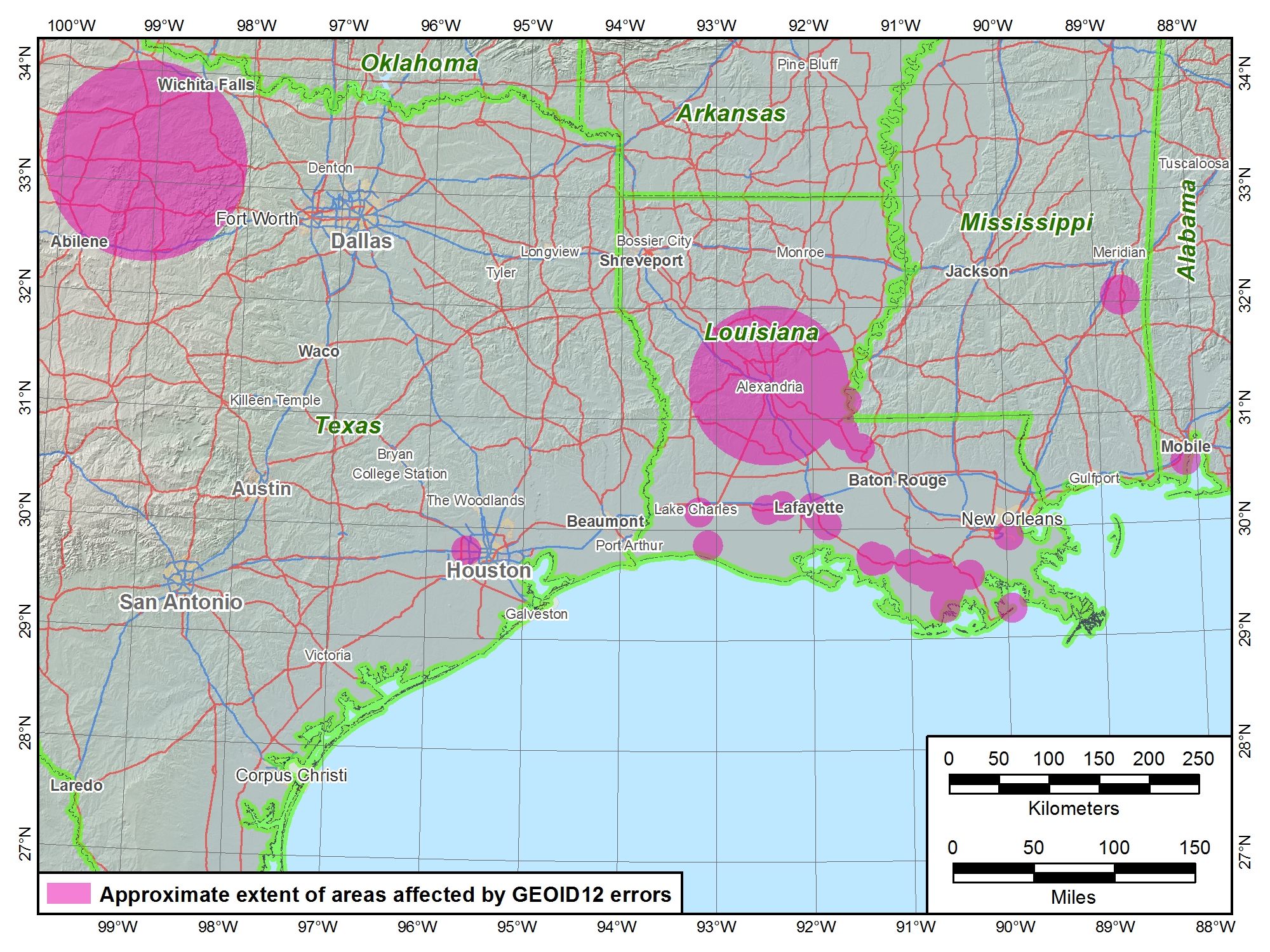
The National Geodetic Survey (NGS) has determined that the new hybrid geoid model, GEOID12, contains localized errors in Louisiana, Mississippi, Texas, and Alabama. Some of these errors are in addition to those identified in the previous notice. Click here for more information.
Well a good chunk of the area we work in are in the pink so to speak...