

I was looking at an old map a few days ago, and saw a portion of a map that showed Sections, Townships, and Ranges in Tennessee.
I have looked around a little, and have not been able to track down any information on this. I have also seen a few descriptions that have referenced STR in Tennessee.
Does anyone have any information that they would care to share on this subject? I have just started my research into this subject.
Thanks in advance,
Jimmy
I left Texas for 2 years during '87-'88, when one of the last slumps hit.
I worked for a firm in south Memphis, just north of State Line Road. They told me the road was off by a mile, that it was laid out wrong by a misreading of latitude. For the south mile of SE Memphis, the roads were set in mile squares. I found some surveys by St. George Richardson dated to the early 1900's that seemed to be "sectionalized". He was highly regarded there. If St. George said he set something, I told the boys to dig until they found it. We would find his corners in center of roads, or deep in plowed fields.
I found a number of informative links about township surveys in Tennessee a few years back on some geneology sites. The links may no longer exist, but if I find them I will post them.
- jerry
here are some links you can probably expand on quickly.
http://www.tn.gov/tsla/history/guides/guide10.htm
http://www.tngenweb.org/tnland/tn2dmap.htm
http://tngenweb.org/warrentn/d123map.htm
http://www.tngenweb.org/tnland/survdist.htm
As you might research PLSS history, the colonies agreed to relinquish their western lsnds in favor of the central government circa 1789. But states were allowed some consideration for existing state obligations, often for the purpose of paying off officers and enlistees of revolutionary war soldiers.
Many states did so and issued patents to their western lands. Tennesee is largely the western lands of North Carolina who continued to issue patents based on metes and bounds for a long time. Those patents were often in conflict on paper with the rectangular system which was not fully carried out, or at least you can say was never fully implemented.
Townships in the western side of the state were not freed from Indian interests until later. The framework of townships over there is more evident on the ground having perhaps less conflicts with state prior state grants.
Note also that some Alabama Land office surveys now fall in Tennesee due to a change in the state line. You can see lines of occupation from those surveys continuing well up into TN on topo maps and aerial photos.
- jlw
The Chickasaw Indians ceded western Tennessee and far western Kentucky in 1818. This tract was bounded by the Tennessee, Ohio, and Mississippi Rivers, and on the south by the state line as later run by General James Winchester.
However, the Winchester line was too far north, and Tennessee later had the line re-run further south.
In 1832 the Chickasaw Nation ceded all their lands in Mississippi. As part of this deal, they were to receive the proceeds from the land sales of the ceded area. This secession went to the Winchester line, therefore, everything south of that line had to be sectionalized prior to the sale.
The Initial Point of the Chickasaw Meridian was a point on the Wolf River south of what is now Lagrange. The difference in the Winchester line and the current state line increases as you go west toward Memphis, but along the Chickasaw Meridian, there are about 2.5 sections within Tennessee.
Information take from "Initial Point of the Rectangular Survey System" by C. Albert White.
Excellent set of links. Much obliged.
As an aside, I think I recall that it was fairly clear that Al White did not make it to the true initial point as it looked to me like he visited in intersection of the meridian with the newer state line which is several miles south of the actual initial point.He must not have had his research done yet when he made his field visit.
Recovering or restoring that point might be a good project for the state societies to undertake unless someone has done it already. The old state line can be roughly followed on aerial photos as are points on section lines in the area.
- Jerry
I have a hard time believing that point is still there. The Wolf River is a slow, meandering stream. It's very likely that the former bank is now in the center of the channel. It would be an interesting project though.
I would love to see the recovery and the installation of a permanent marker for the Chickasaw Meridian initial point done, if possible. I work primarily in the Chickasaw Meridian area in Northeast Mississippi. I helped some with the re-establishment of the Choctaw Meridian initial point in Copiah County many years ago. It was a very interesting piece of work that the BLM and the Mississippi Association of Professional Surveyors did to re-monument that historical mark.
My father in law teaches surveying in Knoxville. It's a meets and bounds state.
> My father in law teaches surveying in Knoxville. It's a meets and bounds state.
Then explain this:

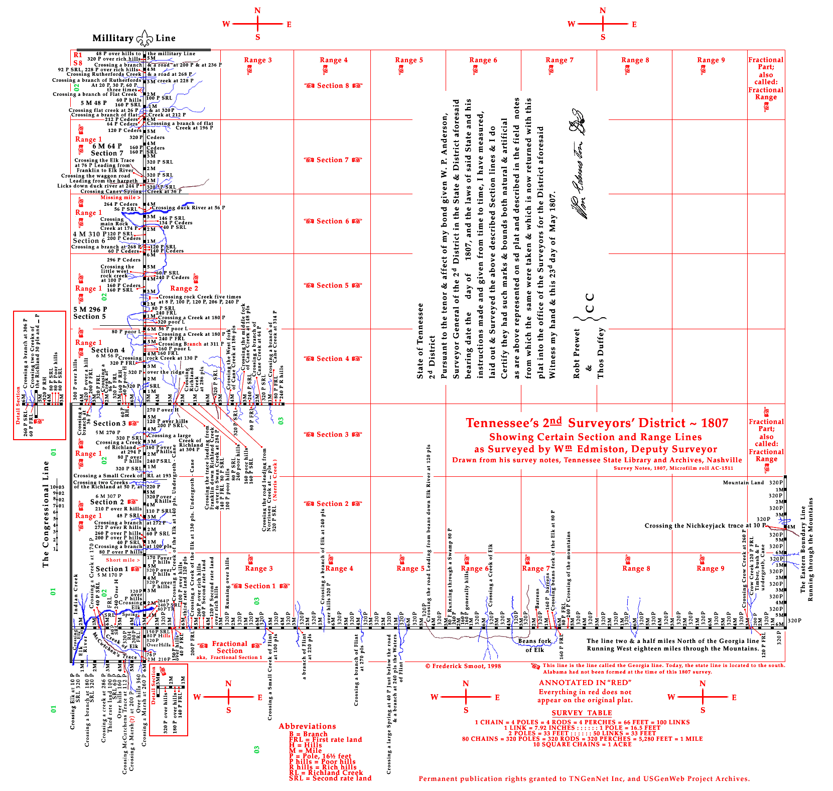
Early PLSS System in Tennessee> in 1980
When I took the exam there was actually a question regarding Townships. Because a small portion of TN was laid out in townships we had to demonstrate our superior knowledge of Sectioned land by breaking a township into sections, OK, not really break it down but at least show that we knew how to number one! LOL
Easiest question on the exam, at least the only non-subjective one!
Stone Hound,
Thank you for the reply.
I started my surveying career in Tennessee in 1995, and have been licensed here since 2001. Occasionally we do run across deeds that reference PLSS references in Tennessee. As Foggy indicated below, there were portions of Tennessee that were initially laid out in PLSS fashion, but it went away over time.
I am in the process if researching a parcel, in Tennessee, that has a few references to the PLSS system, so that is why I asked the question.
What is your father in law's name? We have a professor from UT Knoxville on the the TAPS Board of Directors. Dr. Freeland is a very nice gentleman, and he brings a lot of valuable insight to the Board.
Take care,
Jimmy
Jerry,
Thank you for the links. I have them bookmarked, and will be looking into them over the weekend. It is supposed to be raining here, so I can get caught up on some office stuff.
Tommy, thank you for the email.
Thanks everybody for the replies.
Jimmy