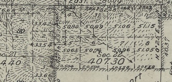
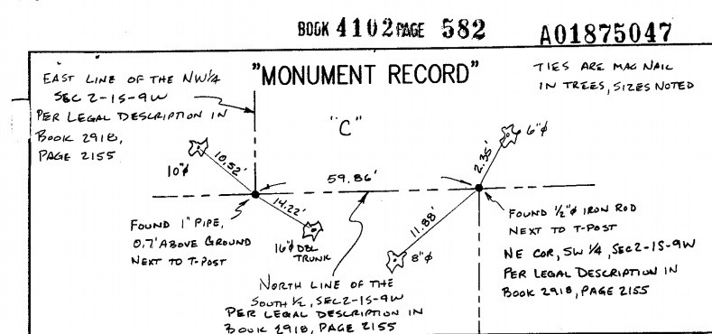
My sister bought a house on an acreage, and I'm looking at what surveys are recorded in the neighborhood. I found this one that has me puzzled.
It appears to show separate monuments set for the SW corner SE 1/4 sec 2 and NW corner NE 1/4 sec 11. I thought those would be the same point - it's not a township line. It's all in a blob of ink with a railroad ROW line and really needed a detail drawing. There doesn't seem to be enough information to calculate anything but his traverse around the parcel surveyed [no bearings on section lines or north-south distances to quarter corner(s) ], and the parcel description makes no reference to the quarter corner(s).
I might understand if somehow he FOUND separate accepted corners for opposite quadrants due to offset ancient fences coming from different directions, but I cannot imagine him SETTING separate corners with no explanation. I guess I need to go to the courthouse and find the corner records - they don't seem to be on line.
Other ideas?
Portion of plat: note North to right
I see a big oblong blob which may indicate two monuments but it could just be a confusing way to annotate a map with two notes and leaders like that.
Are you sure there are two monuments out there, or perhaps are there two labels for the same monument. That would be a strange way to label it, but maybe that's the case. (I would have just said S.1/4Cor Section 2/N1/4 Cor Sec. 11 on one label.
Edit, I hadn't seen Dave's response while I was typing. I am thinking the same thing.
Have you looked at the original survey? Double corners do happen inside townships.
Another hint is that if there were double-corners, there would be different dimensions to each corner, and, more likely than not, a "detail" showing how the corners are situated to each other.
Dave Karoly, post: 339298, member: 94 wrote: I see a big oblong blob which may indicate two monuments but it could just be a confusing way to annotate a map with two notes and leaders like that.
It looks to me that he is being thorough, there are probably two deeds, one that calls the NW corner of the NE1/4, and another that calls the SW corner of the SE1/4, so he labels the same point with both descriptions, but it's one monument. I would not think it's two monuments
The more common situation is a surveyor, or the county surveyor, set a 1/16th corner and the property owners use it for their boundaries and Deed transactions.
Sometimes a Surveyor comes along decades later with a better answer upsetting the apple cart and creating multiple corners.
aliquot, post: 339319, member: 2486 wrote: Have you looked at the original survey? Double corners do happen inside townships.
What circumstances would cause this in the original survey?
Bill93, post: 339331, member: 87 wrote: What circumstances would cause this in the original survey?
I've seen an example in a seminar where a quarter-corner was stubbed in without all the other corners being set for one section, and years later they did an original survey of the other section and set their corner for the other section. Something like that. I don't remember the specifics of the circumstances. It would be shown that way on the original township plat with dates when one was established and when the other one was established.
In my minds eye, the GLO should have held the first corner set. But mistake or not, original surveys are presumed to be error-free.
It can and does happen. You need to research the original GLO surveys. I did a survey that had two brass caps (1/4's) set by the GLO between Sec 1 and Section 12 more than two chains apart. It came about becasue of a partial subdivision of the township and then a later completion survey. It did cause a problem because the landowners long ago only found one corner and used it. In Section 1 they used the wrong corner gong back more than 70 years. When I went out there the landowner, which had found the unused corner over the time, wanted to know what the deal was with this other corner.
3 double corners I know of in Washington state.
1. Two corners 30+/- feet apart.
Circa 1985, surveyor set corner, subdivided lands, and 4 additional surveys hold this corner as the section corner. My firm (before I was hired) go out and find the original evidence, dated 1933. Notify the 1985 surveyor, says he isn't going to correct it, goes before a judge, and determination is to use both corners.
2. Similar to above, but a smaller scale. Multiple surveys found referencing two different distances to the section corner (about 0.5' difference). Find the corner, and determine two surveys reference the top of a bent pipe, three others either refer to the pipe bend or top prior to bend. Due to the historic nature of both locations, I leave the pipe undisturbed and file a land corner record describing the differences.
3. Not relevant to you, but interesting and a unique situation. The section corner falls at the base of an overhanging cliff. The original corner is on top of the cliff, and another corner was set directly underneath it by about 50 feet,.... Likely to avoid hiking up and down the hill... Or perhaps because it's just kinda cool.
summerprophet, post: 339365, member: 8874 wrote: The section corner falls at the base of an overhanging cliff.... it's just kinda cool.
Now that's a great reason for double corner.:good:
I've seen it a couple of times in Illinois, but it was the original survey work that did it. I always suspected it was a occupation thing where no one wanted to call a fence wrong. The couple of cases I remember it wasn't shown on a newer survey but had probably been that way for over a 100 years.
Dave Karoly, post: 339328, member: 94 wrote: The more common situation is a surveyor, or the county surveyor, set a 1/16th corner and the property owners use it for their boundaries and Deed transactions.
Sometimes a Surveyor comes along decades later with a better answer upsetting the apple cart and creating multiple corners.
My favorite... Sec 2, T1N-R9w-3rd PM, St. Clair County, IL.... County Surveyor surveyed the NW 1/4 - started at the W1/4, went east 40 chains and set a post. Then went north to the Township Line and set a post. A few years later, same surveyor surveys the SE and SW 1/4's.....Starts at the S 1/4 and goes north 40 chains and sets a post. One of these corners he calls the center of section, the other is the northeast corner of the southwest quarter.
I agree with MightyMoe that there are probably two different deeds and one begins by labeling the corner one way and the other the other way. I think the surveyor was just being thorough here and not noting two separate corners.
I'm pretty well convinced, given that possible reason, there is only one distance north-south to a quarter corner, and there is no indication of a second triangle symbol.
But if I was doing it and thought it necessary to describe it both ways, I'd put both designations in one label and only say I set the monument once.
The most common reason for double interior GLO/BLM corners are completion surveys and independent resurveys that require a patantee's bona fide rights be protected.
do some research, I have seen the following: original survey of Part of the township, then a completion of the remainder.
the "first" 1/4 lines are protracted, parallel to the surveyed lines as they only need 3 corners to be Patented...those lines control that 1/4.
the completion survey sets the other corners, then the 1/4's are slightly different, but do not control the "first" 1/4, as it is senior and patented prior to the second survey. (both are original GLO surveys)
Weird stuff began to happening shortly after State licensing of land surveyors. Surveyor A believes such and such to be true and works in that manner. Surveyor B has a different view of things. Sooner or later, things aren't going to match perfectly.
I know of a case where the west quarter corner of the section to the east is about 70 feet north of the east quarter corner of the section to the west. Aliquot parts have been created in both sections. Grab the wrong quarter corner and all heck breaks lose pretty quick.


