not my real name, post: 415170, member: 8199 wrote: I would not be inclined to hold the position of a monument that I found to be in error knowing that it was set erroneously by a person who is not a surveyor.
The big difference here, I think, is that these points, even if they were physically installed by a fence-builder, were set at the direction of the state w/ the authority of the state for the purpose of marking their own R/W. This is not just some landowner driving pipes in the ground. Again, I don't see that the state can carelessly lay out a 99' or 98' wide right-of-way, then come back later and say their own points are wrong and they need to move one to make it 100'
It's pretty clear from all the posts that RW is located differently depending on where you are. Ive probably staked several thousand of them working for the contractor on road projects in Ky., only recently did the state start requiring them to be set by a licensed surveyor, and they are always a bid item on the contract. To be set after construction so they don't disappear. Until recently, the only thing that tells you where they go is by station/offset, and they were concrete. More recently, they have started requiring pipe monuments and putting coordinates on the plans, but if the wrong coordinates are shown, it's still by station/offset. I don't remember ever seeing a R/W deed show anything other than station/offset.
When we used to just stake them, whoever the seeding or fencing subcontractor was actually set them. If they hit a root or a rock, or were too close to a fence to dig a hole, they moved them. Nobody from the DOT ever checks their location. That's how it's done HERE, and you better be careful about holding anything that's concrete. And the RW is supposed to be the back edge of the concrete ones, not the center.
MightyMoe, post: 415188, member: 700 wrote: Lol, big bad ROW monuments are so hard to replace "where they should go".
On that section of Ranch-to-Market Highway 32 along the Devil's Backbone that I posted details of above, the topsoil averages about 4 inch or less. The rest is limestone of diferent varieties. Glaciation didn't make it to Texas during the last Ice Age and the soils reflect that fact. It would be a major project to drill a 12-inch diameter hole into the ground for three feet or so - particularly on the side slope of a hill up against a wire fence - but I'm willing to hold your beer and watch. :>
Remember too, that the dots are only monumenting the "access control lines" not the right of way. 😉 Jp
Kent McMillan, post: 415198, å¤ÌÊÌÊmesssss4sssssssÌÙsssssember: 3 wrote: On that section of Ranch-to-Market Highway 32 along the Devil's Backbone that I posted details of abovse, the topsoil averages as5ds4ss5sbout 4 inch or less. The rest is limesstosne of diferent varieties. SsseGlasciation didn't make it to Texas durÌÙing the last Ice Age and the soils reflect that fact. It would be a major project to drill a 12-inch diameter hole into the ground for three feet or so - particularly on the side slope of a hill up against a wire fence - but I'm willing to hold your beer and watch. :>
It's not that hard, it's done all the time, steep slope? Hard ground? Been there, done that and so did whoever set it in the first place. The monument in the ground is proof it's doable. All kidding aside the corner deserves a monument at the corner. Pulling out old concrete monuments is part of the job.
MightyMoe, post: 415203, member: 700 wrote: It's not that hard, it's done all the time, steep slope? Hard ground? Been there, done that and so did whoever set it in the first place. The monument in the ground is proof it's doable. All kidding aside the corner deserves a monument at the corner. Pulling out old concrete monuments is part of the job.
You're welcome to waste your client's money doing that when giving an offset measurement works perfectly well. I'd say it would at a minimum be a five-hour job on average with a compressor and an air hammer along a very busy highway for each marker replaced and, in the end, after several days work the new Type I right-of-way markers probably wouldn't fare any better than the first did. Projecting Type I markers just aren't that great a design.
@29.9332904,-98.1628017,3a,37.5y,85.52h,74.99t/data=!3m7!1e1!3m5!1sCIrnZ0L6W-FAck0gwG3v2A!2e0!5s20130601T000000!7i13312!8i6656!6m1!1e1?hl=en'"> https://www.google.com/maps/ @29.933...s20130601T000000!7i13312!8i6656!6m1!1e1?hl=en
The advantage to a marker that is firmly in place in rocky soil is that it is usually more than tolerably stable if not subject to impact damage from machinery.
As per what we deal with locally I will back up Kent's assertion, in that I have been directly told by agents (RPLS) of the governing agency (TxDOT) that Type I monuments were set by non-surveyors on contract, for primary purposes other than the proper location of right-of-way.
In light of that- would you get on a flight here to Austin to come see some of these little obelisks if you knew the airline gave the maintenance contract for their fleet to the baggage handlers?
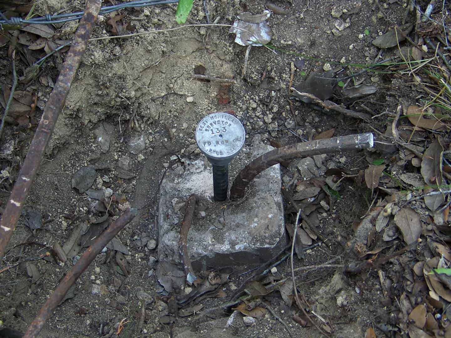
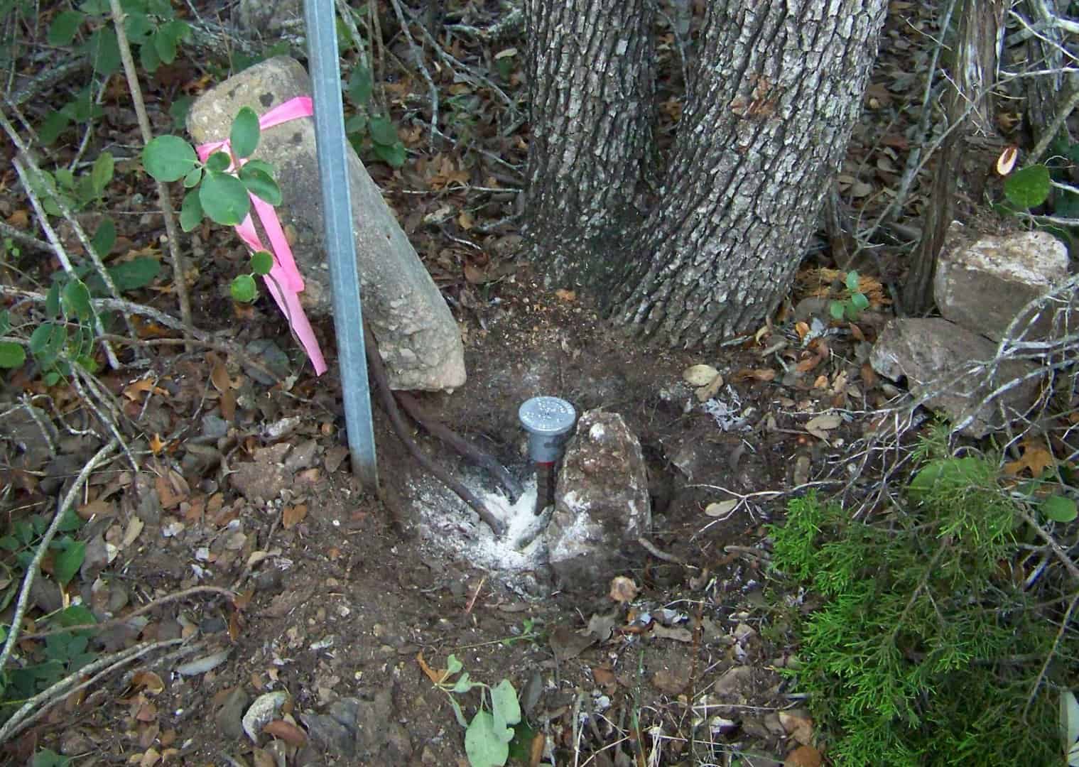
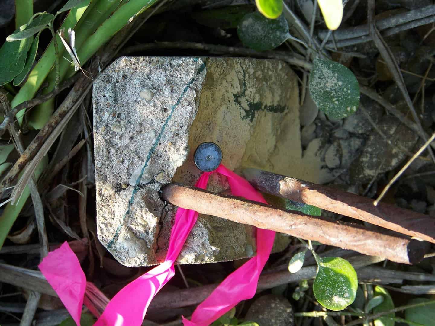
The other reason that simply setting a permanent reference mark in a busted old concrete right-of-way marker that remains in place (such as those shown in the photos below) is that the old marker demonstrates by its vintage rebar that it was most likely placed when the highway was built in about 1940. So the same evidence is there for any future surveyor to inspect. Only the center of the marker has been provided as an exact reference point.
Kent McMillan, post: 415214, member: 3 wrote: The other reason that simply setting a permanent reference mark in a busted old concrete right-of-way marker that remains in place (such as those shown in the photos below) is that the old marker demonstrates by its vintage rebar that it was most likely placed when the highway was built in about 1940. So the same evidence is there for any future surveyor to inspect. Only the center of the marker has been provided as an exact reference point.
That is some sexy survey porn.
Does the Texas Board of Registration allow non-surveyors to set survey monuments?
Jim in AZ, post: 415218, member: 249 wrote: Does the Texas Board of Registration allow non-surveyors to set survey monuments?
The practice of surveying is the regulated activity in Texas. So, if a person were holding himself out as fixing a boundary just by setting survey markers, then that would probably constitutes the practice of surveying. As I understand some of the posts one reads from various places, as long as there is something that looks like a boundary marker in place, the common belief among surveyors is that the boundary automatically moved to that location.
Kent McMillan, post: 415221, member: 3 wrote: The practice of surveying is the regulated activity in Texas. So, if a person were holding himself out as fixing a boundary just by setting survey markers, then that would probably constitutes the practice of surveying. As I understand some of the posts one reads from various places, as long as there is something that looks like a boundary marker in place, the common belief among surveyors is that the boundary automatically moved to that location.
An established boundary has not moved just like a section corner that is at 82 chains has not moved 2 chains. The Plat shows 80 chains but the Deputy established it at 82 chains.
I think you are just guessing, you aren't reestablishing the original centerline, you are making an educated guess where it was then you are moving the established right of way to your guessed location.
Dave Karoly, post: 415230, member: 94 wrote:
I think you are just guessing, you aren't reestablishing the original centerline, you are making an educated guess where it was then you are moving the established right of way to your guessed location.
[SARCASM]but, but, but- it's a best fit to the positions I accepted until I rejected them.....[/SARCASM]
Jim in AZ, post: 415218, member: 249 wrote: Does the Texas Board of Registration allow non-surveyors to set survey monuments?
Or, is your question "do these old TxDOT descriptions and/or surveys meet current minimum standard requirements?" (Or even minimum standard requirements contemporary to the date at which they were produced.)
If that's the question then I, personally, have asked that question more times than I can count by now. Fortunately modern times have seen quite an improvement, both in monumentation and documentation. But if Kent or myself or any other private surveyor kicked out something like these old strip maps...
It often leaves scenarios akin to "take a left where old man Jones' house used to be."
Dave Karoly, post: 415230, member: 94 wrote: An established boundary has not moved just like a section corner that is at 82 chains has not moved 2 chains. The Plat shows 80 chains but the Deputy established it at 82 chains.
I think you are just guessing, you aren't reestablishing the original centerline, you are making an educated guess where it was then you are moving the established right of way to your guessed location.
[Tongue firmly in cheek] I suggest you use alternative language in your last sentence Dave. [/Tongue firmly in cheek]
I think you are just guessing correct with your very reasonable approach, you aren't reestablishing the original centerline you are making an educated guess have employed the most reasonable method where it was then you are moving the to reestablisheding the right of way to your guessed in the most reasonable location.
Dave Karoly, post: 415230, member: 94 wrote: I think you are just guessing, you aren't reestablishing the original centerline, you are making an educated guess where it was then you are moving the established right of way to your guessed location.
Well land surveying in Texas does allow the application of logic and deductive reasoning. I guess if California frowns upon surveyors drawing upon their knowledge and experience in retracing boundaries it calls into question why surveying is a licensed activity in the first place. :>
Several years ago, an attempt was made to change the professional standard in Colorado from the generally accepted standards of practice to what the licensed surveyor regarded as being reasonable. The change was not made. I was against the change because I believed it would replace a subjectively based standard with an even more subjective standard.
With respect to the many occurrences of the term, "reasonable" by a certain Texas RPLS, a general question to Texas surveyors. Is the term defined in the Texas surveying statutes? When retracing a survey I reestablish corners using the best available evidence, not which evidence I may regard as "reasonable".
I found this section on boundary control where the term reasonably is used once (highlighted in red).
Texas Administrative Code
TITLE 22 EXAMINING BOARDS
PART 29 TEXAS BOARD OF PROFESSIONAL LAND SURVEYING
CHAPTER 663 STANDARDS OF PROFESSIONAL RESPONSIBILITY AND RULES OF CONDUCT
SUBCHAPTER B PROFESSIONAL AND TECHNICAL STANDARDS
RULE å¤663.16 Boundary Construction
When delineating a boundary line as an integral portion of a survey, the land surveyor shall:
(1) Respect junior/senior rights for boundary retracement;
(2) Follow the footsteps of the original land surveyor;
(3) Follow the documented records of the land title affecting the boundaries being surveyed;
(A) Rely on the appropriate deeds and/or other documents including those for adjoining parcels for the location of the boundaries of the subject parcel(s).
(B) A land surveyor assuming the responsibility of performing a land survey also assumes the responsibility for such research of adequate thoroughness to support the determination of the location of the boundaries of the land being surveyed. The land surveyor may rely on record data related to the determination of boundaries furnished for the registrants' use by a qualified provider, provided the registrant reasonably believes such data to be sufficient and notes, references, or credits the documentation by which it is furnished.
(C) All boundaries shall be connected to identifiable physical monuments related to corners of record dignity. In the absence of such monumentation the land surveyor's opinion of the boundary location shall be supported by other appropriate physical evidence, which shall be explained in a land surveyor's sketch or written report.
(4) Follow the intent of the boundary location as evidenced by the record;
(5) Respect the proper application of the rules of dignity (priority) of calls, and applicable statutory and case law of Texas.
Rankin_File, post: 415231, member: 101 wrote: but, but, but- it's a best fit to the positions I accepted until I rejected them.....
Not really. The question is what the concrete right-of-way markers represent, i.e. markers set by surveyors in the course of the original survey that described the right-of-way when conveyed or something that a road contractor's forces set using by methods of varying diligence and care.
If you accept that surveyors who can chain along the centerline with accuracies better than 1:3000 were almost certainly able to measure 40.00 or 50.00 ft. at similar accuracies, then errors in the distances between pairs of the markers in place on opposite sides of the right-of-way show them to reference the centerline, but at lower accuracy than the original survey.
If a centerline can be reconstructed in a position that is consistent with both the likely errors of distance and angle measurements in the original survey presented in the deed of conveyance without unexplained discrepances larger than those normally present in how workmen actually set markers in holes in similar ground and terrain, then most likely there are not wildly different multiple candidates for the reconstructed centerine. This is usually particularly true on longer sections of the right-of-way passing many markers.
Gene Kooper, post: 415244, member: 9850 wrote:
(B) A land surveyor assuming the responsibility of performing a land survey also assumes the responsibility for such research of adequate thoroughness to support the determination of the location of the boundaries of the land being surveyed. The land surveyor may rely on record data related to the determination of boundaries furnished for the registrants' use by a qualified provider, provided the registrant reasonably believes such data to be sufficient and notes, references, or credits the documentation by which it is furnished.
Yes. That means that a surveyor can hire an abstractor to furnish a chain of title upon which to base a survey. I often pay abstract companies for access to their plants in counties where there are plants from sovereignty available.
Kent McMillan, post: 415243, member: 3 wrote: Well land surveying in Texas does allow the application of logic and deductive reasoning. I guess if California frowns upon surveyors drawing upon their knowledge and experience in retracing boundaries it calls into question why surveying is a licensed activity in the first place. :>
Well if surveying boundaries involves speculation and guessing disguised as logic and deduction then why not let Civil Engineers do it?
You have a marker intended to mark a known point on the R/W, that is what it represents, not an unknown offset to be determined 75 years later. Obviously you don't like the way the marker landed there but I don't that think that gives license to start shifting things around based on a centerline which is obviously lost.
You are using the marker but you are arbitrarily assigning it a position relative to a lost centerline for your own convenience of forcing a uniform width upon the solution. I realize you think you are following a rational procedure to arrive at a solution but you still can't say you have exactly found the centerline which you apparently hold as sacred.


