Long before State Plane coordinates, the USC&G provided three coordinate systems for New York City. One for the Bronx, one for Staten Island and one for Brooklyn and Queens. Now I was pretty well versed in coordinates before I encountered these legacy systems and when I finally encountered one of these local systems it threw me for a loop.
I was working in Brooklyn and the boss handed me the Report from the USC&G and sent me out to the field. I grabbed some numbers off the coordinate tables and started running lines. And when I got to the end of the traverse I couldn't figure what I had done wrong.
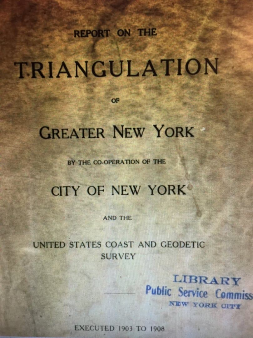
The Report;
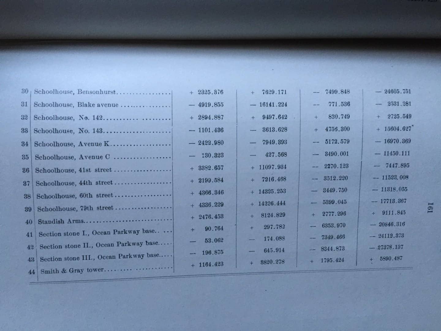
The coordinate tables;
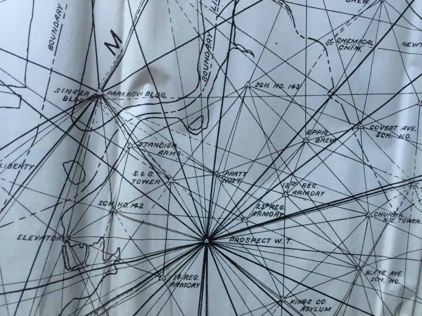
Here's the triangulation diagram detail around Prospect Water Tower, the coordinate origin.
Can you figure out how the government screwed with my naÌøve brain?
Scott Zelenak, post: 362979, member: 327 wrote: Long before State Plane coordinates, the USC&G provided three coordinate systems for New York City. One for the Bronx, one for Staten Island and one for Brooklyn and Queens. Now I was pretty well versed in coordinates before I encountered these legacy systems and when I finally encountered one of these local systems it threw me for a loop.
I was working in Brooklyn and the boss handed me the Report from the USC&G and sent me out to the field. I grabbed some numbers off the coordinate tables and started running lines. And when I got to the end of the traverse I couldn't figure what I had done wrong.The Report;
The coordinate tables;
Here's the triangulation diagram detail around Prospect Water Tower, the coordinate origin.
Can you figure out how the government screwed with my naÌøve brain?
I have used the Bogart system, which was used on Long Island, when surveying up there for the New York USACE. As I recall, it was a simple tangent plane system with the origin at station BOGART. Here is a part of the 1903 description in the IDB:
KV3473'THE STATION IS MARKED BY THE REGULAR U.S.C. AND G.S. BRASS
KV3473'MARKING BOLT SET IN A 6- BY 6- BY 24-INCH GRANITE POST SET IN
KV3473'3- BY 3- BY 4-FOOT CONCRETE. THE EXACT POINT IS A SMALL HOLE
KV3473'1/100 FOOT IN DIAMETER DRILLED IN TOP OF BOLT.
KV3473'
KV3473'LAND WAS BOUGHT BY THE CITY OF NEW YORK AND A TRIPOD AND
KV3473'SCAFFOLD 78 FEET HIGH ERECTED OVER A BOTTLE MARKING OLD
KV3473'STATION. THE STATION WHEN RECOVERED WAS ABOUT 1 FOOT 6 INCHES
KV3473'BELOW SURFACE (NECK DOWNWARD). THE EARTH AROUND THE BOTTLE
KV3473'SEEMED VERY SOFT, SHOWING EVIDENCE OF HAVING BEEN UNCOVERED
KV3473'AT SOME RECENT TIME FOR BELOW THE TOP IT IS BADLY
KV3473'CRACKED. UPON OCCUPATION OF THE SIGNAL THE TRIPOD WAS FOUND TO
KV3473'HAVE SETTLED. THE AMOUNT IS NOTED IN THE OBSERVATIONS.
This was in the days before CORS/HARN, so we had to recover as many triangulation stations as we could. A lot of the stations were on school rooftops, one of the guys got locked out on the roof by mischievous teenagers who would not let him back in.
Can you figure out how the government screwed with my naÌøve brain?
Negative coordinates?
If I recall correctly, BOGART system also had negative coordinates (both were South and West). I have documentation somewhere, but not sure where it is.
On a different project for the city, we had to tie in two monuments in each borough so they could compute a rough translation. Not so hard except in Manhattan, tall buildings messed with the GPS.
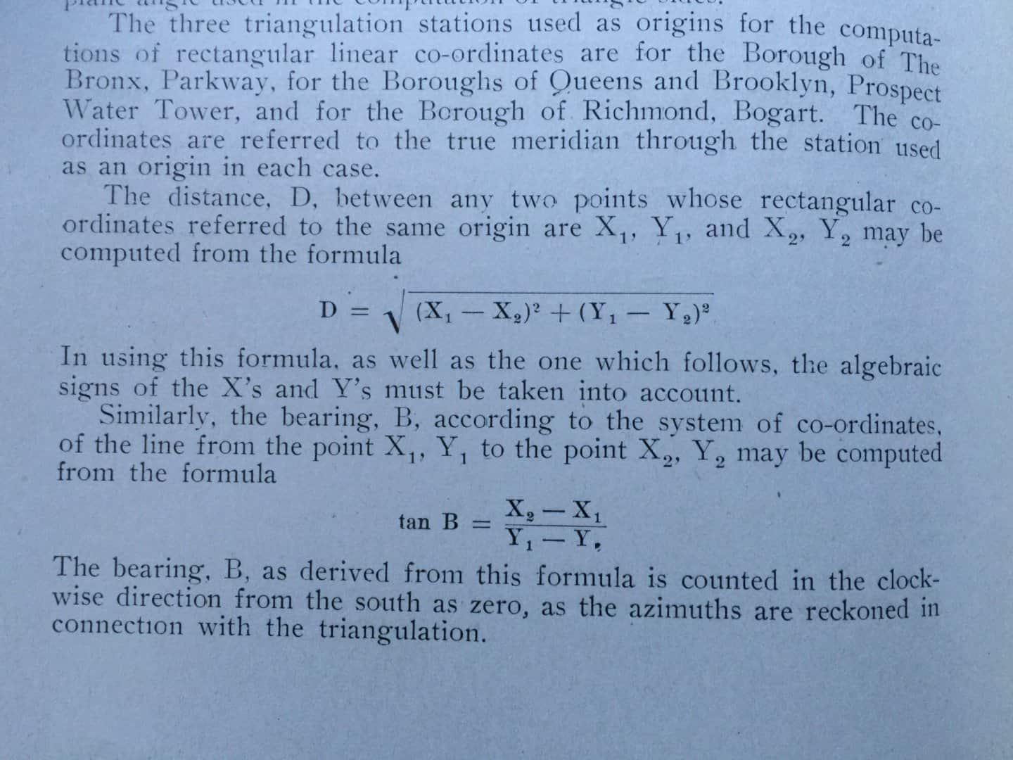
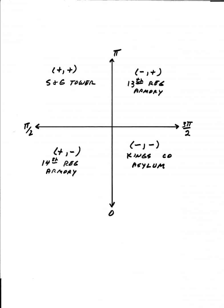
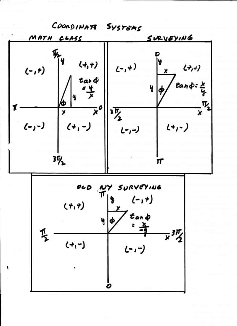
South orientation was the norm in the old days. That makes studying old geodesy textbooks difficult. Here are the signs in each quadrant for Triangulation of Greater New York, in (sign x, sign y) format, along with reference points in each quadrant. Note how this works with the reversal of the order of the coordinates from the numerator to the denominator of the tangent of bearing formula. That makes the sign convention work with the signs of tangents of bearings (azimuths?).
Nothings and Westings,,,,,,some of the old timers used them.
It follows how lat, long are increased; it works but it sure isn't compatible with CAD:-S
Several of my networks have been extended into the negative user coordinate zone and I have never encountered a problem in Carlson.
:gammon:
A Harris, post: 363112, member: 81 wrote: Several of my networks have been extended into the negative user coordinate zone and I have never encountered a problem in Carlson.
:gammon:
East is negative, west is positive.
I would reverse the signs of the X coordinates then enter into CAD.
Dave Karoly, post: 363132, member: 94 wrote: East is negative, west is positive.
I would reverse the signs of the X coordinates then enter into CAD.
I began some user files with a 20,000N and 20,000E to import into my COGO program and have since expanded into networks that extend into negative values.
The files are associated with hundreds of drawings based upon those values and COGO files that are triple backed up in CRD, ASC and *.1K to *.5K files and all shown on a series of *.DWG files and one master *.DWG file that are also triple backed up.
Many of these files were created before the networks went into negative values and it is too late to go thru all of them and translate into positive values.
Another limiter is the HP48GX display and really large numbers and still fit while displaying at least 4 decimal places.
My math mentor taught me to work with negative coordinates and values in the 60s and I really don't worry about them today.
I can open a file in GNSS Solutions and return the values to WGS84 Latitudes and Longitudes with one easy maneuver.
A Harris, post: 363162, member: 81 wrote: I began some user files with a 20,000N and 20,000E to import into my COGO program and have since expanded into networks that extend into negative values.
The files are associated with hundreds of drawings based upon those values and COGO files that are triple backed up in CRD, ASC and *.1K to *.5K files and all shown on a series of *.DWG files and one master *.DWG file that are also triple backed up.
Many of these files were created before the networks went into negative values and it is too late to go thru all of them and translate into positive values.
Another limiter is the HP48GX display and really large numbers and still fit while displaying at least 4 decimal places.
My math mentor taught me to work with negative coordinates and values in the 60s and I really don't worry about them today.
I can open a file in GNSS Solutions and return the values to WGS84 Latitudes and Longitudes with one easy maneuver.
The easting numbers in your stuff get bigger when you go east.
What they are saying is the numbers in NYC get smaller as you go east, the opposite of the usual convention.
A Harris, post: 363162, member: 81 wrote: I can open a file in GNSS Solutions and return the values to WGS84 Latitudes and Longitudes with one easy maneuver.
WGS84...really?
Possible (I suppose), but highly unlikely.
IGS08 (or NAD83) is much more likely, and inasmuch as IGS08 and WGS84(G1674) are pretty much coincident, I guess that might be where you're coming from. NAD83 is more likely for most of us (although Texas IS its own little world).
😉
Loyal
Dave Karoly, post: 363180, member: 94 wrote: The easting numbers in your stuff get bigger when you go east.
What they are saying is the numbers in NYC get smaller as you go east, the opposite of the usual convention.
I understand that part, what can I say except that is NYC for ya, lol
I guess somebody felt that western expansion deserved positive numbers and anything headed toward the ocean and the British was a negative.
Some folks shy away from any use of negative coords and that was what I was quoting on, that it don't bother me.
Loyal, post: 363200, member: 228 wrote: WGS84...really?
Possible (I suppose), but highly unlikely.
IGS08 (or NAD83) is much more likely, and inasmuch as IGS08 and WGS84(G1674) are pretty much coincident, I guess that might be where you're coming from. NAD83 is more likely for most of us (although Texas IS its own little world).
😉
Loyal
Half use the State Plane system and the other half use the Local Zone system and others are on some national datum.
My approach to GPS is totally different, it is a tool that measures very accurately and WGS84 is based on true north.
Receivers are set to record in WGS84 and using the WGS84 datum and it falls in the same place as my recreational GPS units and where things are on Google Earth.
Where I am geographically located where the average elevation is around 250msl lets me operate without having to set a scale factor and the results directly compare to direct values gathered with a TS.
All I do is land surveying and I use GPS to keep my different small projects on the same page.
Put it all together and it works as long as I stay within my network.
I have many control points that are scattered across a few counties that average 4mi apart and creates something looking like equilateral triangle boxes.
To work outside of a box I have to expand my network and work within the new box.
It keeps me aligned with Astro North (from my SMI vocabulary)
This is what I get for never having gone to school for and learning GPS by trial and error.
😉
