Nate The Surveyor, post: 381343, member: 291 wrote: Don't worry about removing the names at cetera, this is an open forum. And all we're looking for it's just figure out what's happening
Yes!
It actually makes it much harder to understand.
Also very important: what state and city?
The laws and practices vary greatly ... location, location, location.
Nate The Surveyor, post: 381343, member: 291 wrote: Don't worry about removing the names at cetera, this is an open forum. And all we're looking for it's just figure out what's happening
I thoroughly disagree.
This poster should redact all names and even specific location. It is the ethical thing to do and if this would EVOLVE to a legal action, maybe comments made here could be detrimental in someway. One needs to take a deep breath and a step back at times before moving forward.
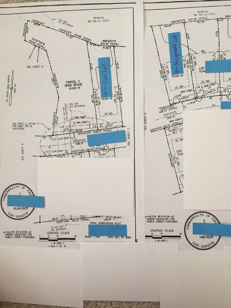
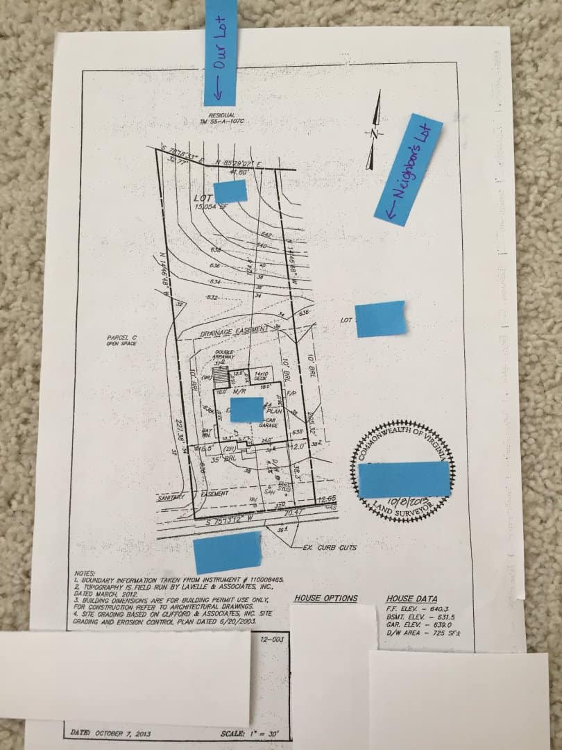
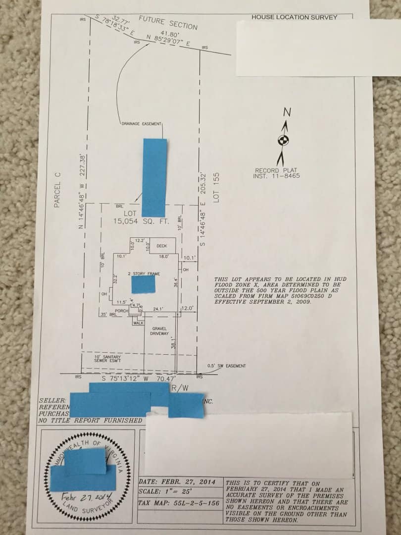
I have already removed all names and lot numbers for the reasons Robert stated. I will be posting the plats shortly. I haven't covered any information you would need to read the measurements and points. As I stated in my original post, we live in VA. Thanks again for all of you who are investing your time and comments about our situation. It is ALL appreciated.
These were all done by 3 different surveyors (different companies) and we had two more done by the builders in 2014 and 2015 (again different companies). All were in agreement as to where the corners were marked. We have requested copies of those surveys from 2014 and 2015, as well as the new one done last month showing different corners.
I hate the idea of doling out advice to property owners on here for the unintended possible consequence of throwing shade on a perfectly honest and legit surveyor, but I'll say this: your two surveys are giant red flags for me. The bearings and distances match the subdivision plat exactly. Not saying they are wrong, but when I see that I automatically assume the surveyor might have bothered to get out of the truck when he/she showed up at your property. But that's probably the extent of what occurred.
flyin solo, post: 381361, member: 8089 wrote: I hate the idea of doling out advice to property owners on here for the unintended possible consequence of throwing shade on a perfectly honest and legit surveyor, but I'll say this: your two surveys are giant red flags for me. The bearings and distances match the subdivision plat exactly. Not saying they are wrong, but when I see that I automatically assume the surveyor might have bothered to get out of the truck when he/she showed up at your property. But that's probably the extent of what occurred.
I appreciate your response and understand what you're saying. These were two surveyors hired by the builder right before and after the build. So, who would take responsibility for the mistake, if these two separate surveyors and two others that followed in 2014 and 2015, are wrong? Could it really be that four different surveyors were wrong and this new one is right? I'm not trying to be argumentative, but genuinely asking this question.
If you called me up and secured my services based upon the information you've already provided, and I were licensed in Virginia and you were good paying the fee that requires me to drive halfway across the contiguous- or, if I were local and it were a 5 minute drive away- I'd be surveying much more than your lot. There are plenty of good indicators of what is SUPPOSED to be happening there. Surveying your lot by itself isn't going to answer what that "supposed to" is. But I can guarantee you this- regardless of how thorough and precise both the original surveyor and I were in performing our duties, your bearings and distances between each and every point would not match. Might be off a minuscule amount on any given line, might be a foot or more. All I can take from separate surveys done by separate surveyors where lot lines and building ties are all in complete lockstep is that somebody(s) didn't do their job FULLY. Again- that may be an incorrect assumption, but I bet I'm right 99 times out of 100.
Joanie, post: 381338, member: 11920 wrote: Here are two responses the builder received from his surveyor regarding our concerns. We made the builder aware of our concerns on the day the stakes went in.
Response from June 3rd (surveyor to builder):
"Thank you for sending the Lot ### house location survey plat. Note there are no tie dimensions from the dwelling to the left or rear lot lines.
The resite shows where the house is proposed to be located, not its actual as-built location.
On the [name removed] plat, the surveyor calls out each of the lot corners as being an iron rod set, not found.
The geometry of the Lot ### corners we found work fairly well together, meaning the bearings and distances closely match the subdivision plat of record, however, they appear to be shifted to the right.
Without meeting with the other surveyor, there really isnÛªt a way to accurately determine why the Lot ### corners were set in their current locations.
I have worked on the [name removed] project for many years. We staked out the utilities and roads for construction, as-built the roads and utilities, and have continued to work on with house construction stakeouts. We are still utilizing the original control we established at the beginning of the project ten plus years ago.
The bottom line is this, either the Lot ### corners are correct and ALL the other corners we found in Phases 5, 6 and 7 are in the wrong location (highly unlikely), or, ALL the other corners we found are in the correct location and the corners on Lot ### are not."
Response from July 12 (surveyor to builder):
"I sent a field crew back out to verify the property corner locations in this area. We recovered and located the property corners on lots ### thru ###, lots ### thru ###, lots ### thru ###, and Parcel #. All the property corners located on these 24 lots agree with where we set the property corners on Lot ###.
We did not ÛÏmoveÛ the Lot ### property lines. We set the Lot ### property corners in the correct location per the subdivision plat of record."
The problems I have with these statements are that there were no engineers out doing work on 24 properties in the neighborhood as stated. It would have been highly noticeable. We have a very active neighborhood facebook page and people talk about all the goings on of the neigborhood - no one saw them. In addition, we have the subdivision plat record in our possession and it shows the lot corners as they were previously marked. So, his statement about setting the corner per the subdivision plat record is completely false.
Oh my aching back...setting new marks a foot from the original marks is completely improper. Especially since you already detrimentally relied on the originals. It is possible they were set a foot off but that is not relevant to the lot line locations. Your beef is with the developers and the Surveyors moving established lot lines, not your neighbor. If your neighbor loses a foot because someone blundered in 2009 then they have a potential beef with the developer, et al.
Those second two surveys don't look like boundary surveys to me. They don't indicate any found or set monuments. They are just cartoons. The first one has black dots, presumably monuments (rods or pipes) but I don't see a legend.
Joanie, post: 381365, member: 11920 wrote: I appreciate your response and understand what you're saying. These were two surveyors hired by the builder right before and after the build. So, who would take responsibility for the mistake, if these two separate surveyors and two others that followed in 2014 and 2015, are wrong? Could it really be that four different surveyors were wrong and this new one is right? I'm not trying to be argumentative, but genuinely asking this question.
With what you have shown here I don't see a mistake yet. What you have said was there are some stakes, and crosses in the pavement. No iron pins found yet at the corners. The plats are for individual lots. That alone does not show the complete picture. A competent survey would have to be across several lots each side of the 2 lots in question with regards to the filed subdivision plat to get an answer. Each lot does not stand on it's own, but as a part of the subdivision as a whole. You're going to have to get a surveyor to measure and recover lot corners knowing there is a conflict growing. This is not complicated. But it needs to be done with openness. Much cheaper than the legal route.
flyin solo, post: 381361, member: 8089 wrote: I hate the idea of doling out advice to property owners on here for the unintended possible consequence of throwing shade on a perfectly honest and legit surveyor, but I'll say this: your two surveys are giant red flags for me. The bearings and distances match the subdivision plat exactly. Not saying they are wrong, but when I see that I automatically assume the surveyor might have bothered to get out of the truck when he/she showed up at your property. But that's probably the extent of what occurred.
Difference in local practice. Not saying one way is right or wrong but this is what you would get by me as well. Maybe it's a colonial state thing, not sure.
I do find it really hard to believe that NONE of the iron rods set on the target property are still in the ground. There has to be some left, these were set in 2009.
The rods seem to also be set during the construction process, either during or with the as built/survey for the closing. Does this make them original? Not sure the procedure in VA, but here in NY no corners are set during the original subdivision. Just some reference monuments at PCs etc.
I would assume since this is a new subdivision and the corners had never been previously placed, (or so it seems, not positive) these corners would hold as original, esp with the reliance.
They have to be found. They should be there. You need a pin finder and you'll recover them in minutes.
Dave Karoly, post: 381372, member: 94 wrote: Those second two surveys don't look like boundary surveys to me. They don't indicate any found or set monuments. They are just cartoons. The first one has black dots, presumably monuments (rods or pipes) but I don't see a legend.
I agree. They look like "mortgage location reports", which dangerously look like surveys, but really aren't.
Dave Karoly, post: 381372, member: 94 wrote: Those second two surveys don't look like boundary surveys to me. They don't indicate any found or set monuments. They are just cartoons. The first one has black dots, presumably monuments (rods or pipes) but I don't see a legend.
The last has IRS at each corner for iron rod set
Joanie,
I will concede, Robert may well be right... In a legal environment. However, in the dig to get to the bottom of things, I like names.
What if the plats are fictions, and the builder just measured down the street, with a 100' tape, And somebody at the back end held 101'?
If you post a copy of the latest survey, thatd be good.
Land surveying. There's usually more to the story.
N
Wendell, post: 381377, member: 1 wrote: I agree. They look like "mortgage location reports", which dangerously look like surveys, but really aren't.
I believe they are truly surveys. The very first one I posted (subdivision plat) is specifically referenced (surveyor name and date) in our deed as the land we purchased. The 3rd one I posted (the one done prior to closing) is line itemed in our settlement papers and billed to us as "Survey" "performed by ______" for $350. It was included in our closing costs.


