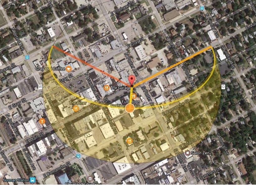
This guy shows the path of the sun on any date and its position at any time between sunrise and sunset on that date. It also gives the sun's altitude and azimuth for that time and lets you choose between a map and satellite view.
The view in the link is at the base of a wind turbine in the first operational wind farm in NC. It powers an Amazon.com facility in southern VA. Not without controversy at both the state and county levels. I was messing around with shadow flicker from wind turbines and found that this web site calculates the length of a shadow for a given height structure at a given time and date.
In Greensboro, NC the streets run generally north-south and east-west, so around the equinox, the sun is guaranteed to blind east-bound drivers on their way into town early in the morning. This web site models that nearly perfectly. To me, anyway, that's just way, way cool.
http://www.suncalc.org/#/36.3222,-76.4123,16/2017.05.28/13:33/100/2
MathTeacher, post: 430197, member: 7674 wrote: ...In Greensboro, NC the streets run generally north-south and east-west, so around the equinox, the sun is guaranteed to blind east-bound drivers on their way into town early in the morning. This web site models that nearly perfectly. To me, anyway, that's just way, way cool...
That is a cool site. Thnx for pointing it out.
Equinox sun blinding drivers is bad. Most of Oklahoma is laid out in cardinal directions. However the low winter sun at the solstice can be just as aggravating.
Note the angular bearing of Main St. here in Norman, OK as compared to the solar map:
My trouble in the winter was in the afternoon on a portion of I 85 that traveled southwest. Made me conscious of keeping the windshield clean, inside and out.
That's nothing; I've seen Scott Z. Do that in a fieldbook.
[emoji41]
That poster, RADAR; sure is a swell guy.
It works....I designed/built this house using a sunchart. On the summer solstice the sun was about 71 degrees off the horizon, 22 1/2 during the winter solstice. I laid out a north south magnetic line and squared the house facing south. I held the bottom of the rough opening of the windows on the first floor and projected the angle up to the rafters on each end, the eaves are cut accordingly. This picture was taken in the late spring early summer, see the shade line. The sun got almost to the north wall in the winter and stayed out of the house in the summer. This house is located on N Cary Road in Jefferson, Maine where it could be down to 45 below zero. As long as the sun was shining the house was 65 to 70 degrees inside without any other source of heat. The heat thermosyphoned throughout encouraged by fans and vents, in the summer the house was always cool with the front and skylight windows open. Highly recommend it...
I use this site for time aerial photography. If you can time the flight to occur at solar noon then the shadow cast it on true north. It is helpful as a double check on things.
Sketchup, formerly by Google and now Trimble, provides real time analysis of sun shadows for any location.
Very cool! I shared it with our Geo-spatial folks. Thanks for sharing!


