Reading RPLS is free for the whole profession. Members post, reply, and get the members-only rooms.

Notifications
Clear all
Member Introductions
7
Posts
5
Users
0
Reactions
1,103
Views

Topic starter
Translate
▼
English
Spanish
French
German
Italian
Portuguese
Russian
Chinese
Japanese
Korean
Arabic
Hindi
Dutch
Polish
Turkish
Vietnamese
Thai
Swedish
Danish
Finnish
Norwegian
Czech
Hungarian
Romanian
Greek
Hebrew
Indonesian
Malay
Ukrainian
Bulgarian
Croatian
Slovak
Slovenian
Serbian
Lithuanian
Latvian
Estonian
hi I use my fishfinder gps to map a river. I use insight genesis aka go free software to do this. My gps has waas and I map at 5 to 10 mph. How can I dramatically improve my gps accuracy? My gps updates at 5 times per second. Would dgps help? If so where can I buy an antenna for mylowrance hds5 gen2?
Posted : March 27, 2017 11:50 am

Translate
▼
English
Spanish
French
German
Italian
Portuguese
Russian
Chinese
Japanese
Korean
Arabic
Hindi
Dutch
Polish
Turkish
Vietnamese
Thai
Swedish
Danish
Finnish
Norwegian
Czech
Hungarian
Romanian
Greek
Hebrew
Indonesian
Malay
Ukrainian
Bulgarian
Croatian
Slovak
Slovenian
Serbian
Lithuanian
Latvian
Estonian
According to the specs on your chartplotter, "external antennas supported via NMEA 0183 and NMEA 2000". So in theory you could connect a more accurate GPS with the right cable and NMEA output settings. I've actually thought about trying this for a poor mans hydro survey (only for mapping fishing spots of course!).
Posted : March 27, 2017 12:19 pm

Translate
▼
English
Spanish
French
German
Italian
Portuguese
Russian
Chinese
Japanese
Korean
Arabic
Hindi
Dutch
Polish
Turkish
Vietnamese
Thai
Swedish
Danish
Finnish
Norwegian
Czech
Hungarian
Romanian
Greek
Hebrew
Indonesian
Malay
Ukrainian
Bulgarian
Croatian
Slovak
Slovenian
Serbian
Lithuanian
Latvian
Estonian
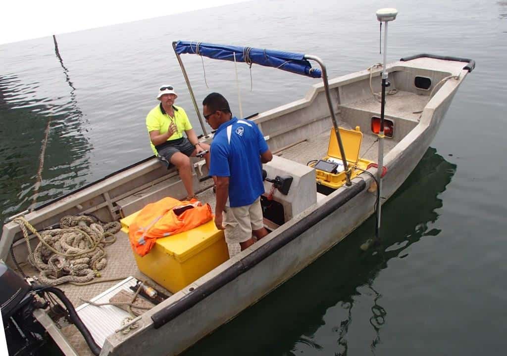
Here's the setup the other way around. X, y, z of the transducer via RTK, depth from the sounder back to the controller = seabed elevation.
Posted : March 27, 2017 12:59 pm

Translate
▼
English
Spanish
French
German
Italian
Portuguese
Russian
Chinese
Japanese
Korean
Arabic
Hindi
Dutch
Polish
Turkish
Vietnamese
Thai
Swedish
Danish
Finnish
Norwegian
Czech
Hungarian
Romanian
Greek
Hebrew
Indonesian
Malay
Ukrainian
Bulgarian
Croatian
Slovak
Slovenian
Serbian
Lithuanian
Latvian
Estonian
Try these guys. I've bought from them and visited their store, although they don't sell much over the counter.
Posted : March 27, 2017 3:43 pm

Translate
▼
English
Spanish
French
German
Italian
Portuguese
Russian
Chinese
Japanese
Korean
Arabic
Hindi
Dutch
Polish
Turkish
Vietnamese
Thai
Swedish
Danish
Finnish
Norwegian
Czech
Hungarian
Romanian
Greek
Hebrew
Indonesian
Malay
Ukrainian
Bulgarian
Croatian
Slovak
Slovenian
Serbian
Lithuanian
Latvian
Estonian
Mikemmm, post: 420457, member: 12605 wrote: hi I use my fishfinder gps to map a river. I use insight genesis aka go free software to do this. My gps has waas and I map at 5 to 10 mph. How can I dramatically improve my gps accuracy? My gps updates at 5 times per second. Would dgps help? If so where can I buy an antenna for mylowrance hds5 gen2?
Find any dealer that sells the hds5:
http://www.lowrance.com/en-US/Products/NMEA-2000/Point-1-en-us.aspx
This unit is a 10 hz unit, and looks like it should plug right into your unit. Here's the installation manual:
http://www.lowrance.com/Root/Lowrance-Documents/GPS-Compass_IG_EN_988-10439-002_w.pdf
Posted : March 27, 2017 6:11 pm
Topic starter
Translate
▼
English
Spanish
French
German
Italian
Portuguese
Russian
Chinese
Japanese
Korean
Arabic
Hindi
Dutch
Polish
Turkish
Vietnamese
Thai
Swedish
Danish
Finnish
Norwegian
Czech
Hungarian
Romanian
Greek
Hebrew
Indonesian
Malay
Ukrainian
Bulgarian
Croatian
Slovak
Slovenian
Serbian
Lithuanian
Latvian
Estonian
Richard Imrie, post: 420468, member: 11256 wrote: Here's the setup the other way around. X, y, z of the transducer via RTK, depth from the sounder back to the controller = seabed elevation.
I did not think rtk was practical for boating. Can I use dgps?
Posted : March 28, 2017 1:07 pm
Translate
▼
English
Spanish
French
German
Italian
Portuguese
Russian
Chinese
Japanese
Korean
Arabic
Hindi
Dutch
Polish
Turkish
Vietnamese
Thai
Swedish
Danish
Finnish
Norwegian
Czech
Hungarian
Romanian
Greek
Hebrew
Indonesian
Malay
Ukrainian
Bulgarian
Croatian
Slovak
Slovenian
Serbian
Lithuanian
Latvian
Estonian
RTK gets you centimeter accuracy on x, y, z of the transducer position but you need a base and rover (or network rover). I haven't heard of dgps for a long time.
Posted : March 29, 2017 3:08 am