
Has anyone made a research onto the thermal expansion rate of the rod spike that is used to mark the BMs? If I remember correctly, it was one of the points of discussion a long time ago in a professional symposium regarding procedures. The gist of the discussion was - was it worth all the costs for carrying out 1st order level work which as you suggested covers procedures/equipment over results if the displacement of the BMs due to heat & earth movements is greater than 1st order limits.
In short, after going through the trouble and establishing the BMs, the monuments or bolt itself has a greater thermal expansion than the invar material.

I would guess that the thermal expansion of the deep 3D type monuments is low given the fact that the majority of the rod is buried in earth. The ground temp does not fluctuate much at 10 to 20 feet below the surface.

John Putnam, post: 419991, member: 1188 wrote: I would guess that the thermal expansion of the deep 3D type monuments is low given the fact that the majority of the rod is buried in earth. The ground temp does not fluctuate much at 10 to 20 feet below the surface.
That's the consensus of the sources I've seen.


You will note in the image above ( https://www.ngs.noaa.gov/web/tools/updates/windesc5/dformat.documentation.htm#A.10 ) that NO monument is considered completely reliable. Unfortunately many submitters to NGS like to supercede these stability codes thinking their poured-in place concrete monuments are surely "B" stability not the "C" automatically assigned by the description software.
There are two separable issues: the variability of the monument (including susceptibility to temperature effects) and the variability of measurements. Since the accuracy of a least squares adjustment is dependent on the measurements containing only random errors it is incumbent on the submitter to provide sufficient data to allow for corrects and modeling of effects on the measurements.
If you click on the link to the Bernsten site from this site you can see some details on what is involved in setting modern 3-D monuments. Note the provision of a greased sleeve extending to the depth of frost penetration enclosing the rod to isolate it from ground movement.
On the issue of mark susceptibility to temperature changes even some CORS are impacted. See: https://www.ngs.noaa.gov/CORS/Articles/SchenewerketalGPSSol1999.pdf
Cheers,
DMM

"Here's something: In Oklahoma, Published NGS Benchmarks are notoriously inconsistent with the results we get from the CORS. I'm talking 0.3 foot or so. Not all of them, but you never can tell where the bad ones are."
I suspect that the issue in Oklahoma and many other western states is not the vertical control may be bad but the accuracy of the geoid model. If you look at the NGS GEOID12B accuracy map - 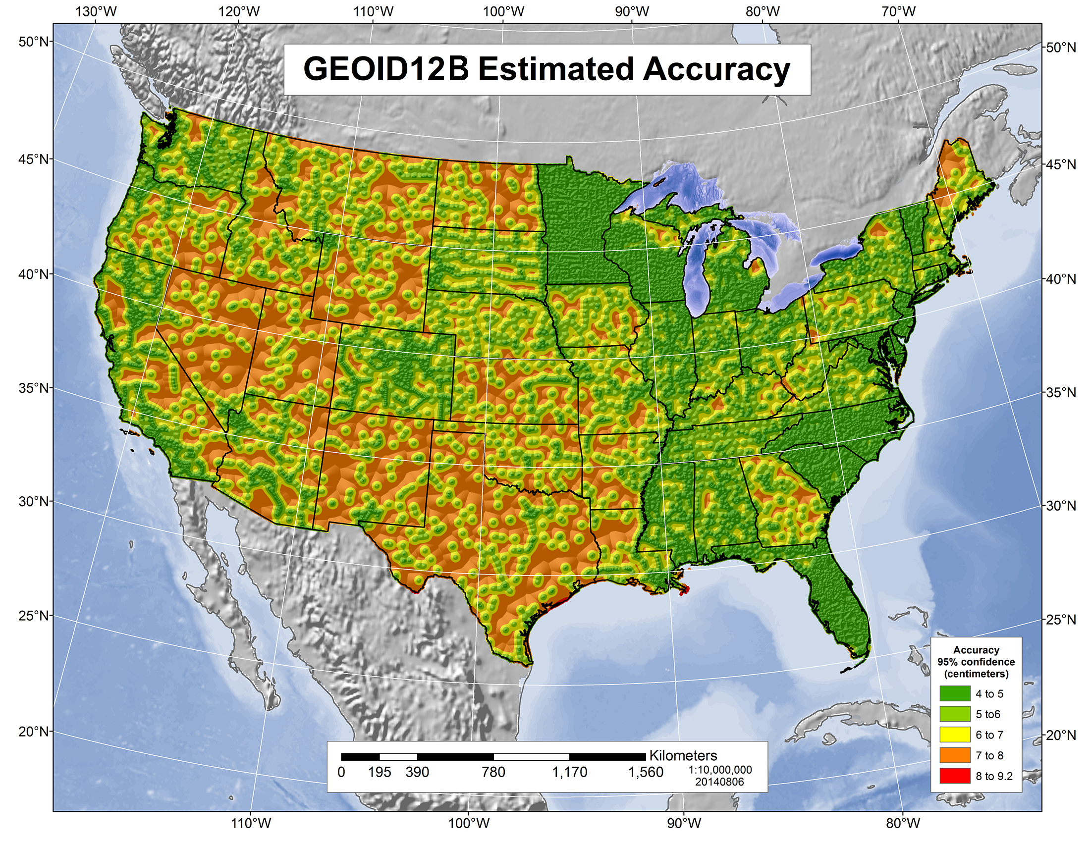 you can see that in many parts of the state the model as an estimated accuracy of 6-8 cm (.2 - .3 ft). To a great extent this is due to the lack of GPS on NAVD 88 bench marks in the state. If surveyors in OK (and other states where the model is not so good) want it to improve then they need to make an effort to perform those observations and submit them to NGS via OPUS Shared Solutions -- https://www.geodesy.noaa.gov/OPUS/view.jsp&apos ;"> https://www.geodesy.noaa.gov/OPUS/view.jsp. You can also evaluate GEOID12B accuracy from the on-line tool -- https://www.ngs.noaa.gov/cgi-bin/GEOID_STUFF/geoid12B_prompt1.prl&apos ;"> https://www.ngs.noaa.gov/cgi-bin/GEOID_STUFF/geoid12B_prompt1.prl. For example, a random point near Broken Bow at 34d 00m 00s/94d 42m 00s returns an uncertainty of 6.9 cm (95% confidence)

GeeOddMike, post: 420075, member: 677 wrote: Unfortunately many submitters to NGS like to supercede these stability codes thinking their poured-in place concrete monuments are surely "B" stability not the "C" automatically assigned by the description software.
Would a solid-looking and 6 ft deep storm sewer inlet structure rate a 'B' ? An abutment or wing wall for a small bridge?

base9geodesy, post: 420095, member: 7189 wrote: "Here's something: In Oklahoma, Published NGS Benchmarks are notoriously inconsistent with the results we get from the CORS. I'm talking 0.3 foot or so. Not all of them, but you never can tell where the bad ones are."
I suspect that the issue in Oklahoma and many other western states is not the vertical control may be bad but the accuracy of the geoid model. If you look at the NGS GEOID12B accuracy map -
This is the frustrating thing about GPS and elevations. Geoid models were created to shift ellipsoid heights to orthometric elevations.
The early models were challenged at best, then the ellipsoid heights went through changes, not because the earth is shifting but because the system gained more accuracy. So as ellipsoid changed, and new Geoid models were released each change would shift the resulting elevation numbers. They all can't be right since they don't match. The number from 2008 shouldn't be different from the number in 2009, but they often were and sometimes the difference was considerable.
The people calculating all this have done amazing work, but it doesn't mean they could preform magic, they can only use data that is available to them. For the entire time of GPS observations I have used the bench mark system when possible, none of those have changed in my area with the exception of disturbed monuments which always needs to be considered. I'm glad I have done that, there were many instances where using CORS/OPUS has caused issues when using stable NAVD88 elevations didn't.
Moving forward it's going to be a mix, the new 2020 data and the old NAVD88 data; the 88 data will be imbedded in projects and particularly FEMA for a long time and surveyors are going to need to be able to work in both for many years to come.
base9geodesy, post: 420095, member: 7189 wrote: "Here's something: In Oklahoma, Published NGS Benchmarks are notoriously inconsistent with the results we get from the CORS. I'm talking 0.3 foot or so. Not all of them, but you never can tell where the bad ones are."
I suspect that the issue in Oklahoma and many other western states is not the vertical control may be bad but the accuracy of the geoid model. If you look at the NGS GEOID12B accuracy map -
While a proponent of the GPS on BM effort, there remain serious issues with the bench mark network itself. The attrition of the network combined with geophysical effects on those still in place makes the corrector surface suspect as a good solution.
The geoid changes due to changes like oil be gas extraction, sediment loading, earthquakes, erosion and other mass loss, groundwater withdrawal, etc.
Without some monitoring and additional high-accuracy leveling the monumented network becomes less relevant to those needing good heights.
Once the snapshot of the national geoid is accomplished, who decides where a "movie" is needed?
Bill93, post: 420134, member: 87 wrote: Would a solid-looking and 6 ft deep storm sewer inlet structure rate a 'B' ? An abutment or wing wall for a small bridge?
I like the guidance in https://www.ngs.noaa.gov/PUBS_LIB/GeodeticBMs.pdf
A six foot deep structure in Minnesota might not be very stable.
I would worry less about frost heave with storm structures than the adjustment rings breaking.
Bill93, post: 420134, member: 87 wrote: Would a solid-looking and 6 ft deep storm sewer inlet structure rate a 'B' ? An abutment or wing wall for a small bridge?
Had a little issue arise while composing my response. While I do recommend review of the NGS linked above, my comment about stability codes were intended to highlight the fact that such codes are too subjective. I have worked with folks who do searches with stability codes as a high priority. Like the satellite visibility notes and others on the NGS data sheets, with the influx of data from non-NGS sources I have seen these values become less useful.
Of course, I always wondered about the accuracy of the "pack times" in old descriptions. I always seemed not to meet or exceed their times. Pack times were in descriptions of monuments requiring one to leave their vehicle and "pack" their equipment to the site. Nowadays people want monuments in convenient locations and do not need to worry about intervisibility. I always liked packing equipment to remote high sites with great views and splendid isolation.
This is the frustrating thing about GPS and elevations. Geoid models were created to shift ellipsoid heights to orthometric elevations.
Why use a geoidal reference for your elevation? Why not use default wgs ellipsoidal reference elevation values? Then do a datum shift?
If you have WGS 84 ellipsoid heights and transform them to a different datum (e.g. NAD 83) you still have ellipsoid heights which have nothing to do with the earth's gravity field. You still need a geoid model to obtain orthometric heights.
base9geodesy, post: 420219, member: 7189 wrote: You still need a geoid model to obtain orthometric heights.
Although for small areas the inconcentricity between the geoid and the ellipsoid may be too small to matter. (I may have just invented a new word.)
Jim Frame, post: 420225, member: 10 wrote: for small areas
Just as, for small areas, 10000, 10000, 100 works well. If you use ellipsoidal heights then GNSS is more convenient and no vertical conversions are needed at all.
But somebody is probably going to ask for NAVD88, and even if they don't, for a larger project in an area with a bumpy geoid the simple method risks drainage inconsistencies.
Lots of good discussion in this site's archives on the WGS84 v NAD83 v ITRF and related issues. In short, assertions that one has an WGS84 height requires a lot of clarifying information. NGA does have an on-line tool providing geoid-ellipsoid separations based on their EGM see: http://earth-info.nga.mil/GandG/wgs84/gravitymod/egm96/intpt.html Evidently they did not consider developing a version for their EGM 2008 which is complete to spherical harmonic degree and order 2159!!!
As for heighting using GNSS with the intent of deriving an orthometric height, the PDF file shows the relationship of the height systems: h = wrt the ellipsoid, N = the distance from the ellipse surface to the geoid surface (AKA geoid height) and H = orthometric height.
The three surfaces are NOT parallel. Using the geoid-ellipsoid separation at a point as a constant over an area is not necessarily accurate. The definition of "small areas" is moot.
BTW, while doing some site maintenance I came across an excellent presentation by Dr Dru Smith of the US NGS related to the issue of heighting in areas undergoing subsidence. It is linked as "additional materials" for Class 23 here: http://geodesyattamucc.pbworks.com/w/page/13931102/FrontPage#Class2317April2013MoreonthenbspGeoidnbsp
Cheers,
DMM

Finally remembered how to convert a TIFF to JPG. Image taken from Dr. Smith's presentation linked in prior post. Same as PDF above.
FrancisH, post: 420211, member: 10211 wrote: Why use a geoidal reference for your elevation? Why not use default wgs ellipsoidal reference elevation values? Then do a datum shift?
I apply a geiod model to the elevations, this changes the ellipsoid height which no one cares about and holds NAVD88, in essence a datum shift.
Jim Frame, post: 420225, member: 10 wrote: for small areas the inconcentricity between the geoid and the ellipsoid may be too small to matter
For my local geoid slope, that difference changes by about 2.8 cm/km or 0.15 ft/mile north-south, and much less east-west. There are places where it is MUCH steeper. "Small area" depends on your error tolerance and how much the local geoid is tilted.
The ellipsoidal height difference between NAD83 and IGS08 or WGS84 ellipsoid is more nearly constant over that area; it varies two orders of magnitude less than the geoid.
Above in GeeOddMike post (note: when i looked at post by this person I always thought it was " Gee Old Mike" till I put on my close- up glasses) the nice picture is not correct---- at least for the conterminous United States.
Why don't they show a correct drawing of the relationship of the ellipsoid, ground and geoid. That should not be asking to much from NGS. The math is very simple but a correct picture is worth a 1000 words.
** In the conterminous United States the ELLIPSOID is ABOVE the Geoid. In Alaska the ELLIPSOID is BELOW the Geoid.
JOHN NOLTON