I tagged this onto Jerry's Salinas post but reposting it here.
@ j. penry
I wonder if anyone has come across any older USCGS markers.
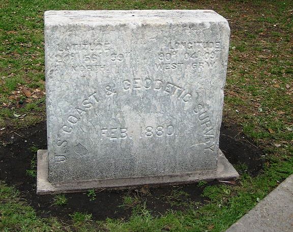
Here is the oldest USCGS marker that I have ever seen.
It is located in downtown New Orleans in Lafayette Square across from the Federal Courthouse and also adjacent to the original City Hall.
I believe it was part of the Tidal Survey done by USCGS in 1880
You can see the brass pin on on top,
Very cool! It seems that someone has found at least one or two of the original eleven triangulation stations near Staten Island placed in 1817.
J. Penry, post: 386306, member: 321 wrote: Very cool! It seems that someone has found at least one or two of the original eleven triangulation stations near Staten Island placed in 1817.
Thus marker is within walking of the WW2 Museum ..if you make it there one day.
They should sell your WW2 books at the museum
I found (and by found, meant I was led by an employee of the Rockefeller estate, to) station Buttermilk 1817.
He then showed me three reference disks surrounding the station, forming a triangle, and proudly explained how that gave it the name "triangulation station".
I then showed him the fourth reference disk and explained the true nature of "triangulation".
I think I ruined his day.
The mark you found is AU1060 for bench mark K 168, however it was originally set as New Orleans Longitude - an astronomic station.set to help control the local triangulation and compute deflection of the vertical. The station is described on page 188 of USC&GS Special Publication 10 "Astronomic Determinations."
base9geodesy, post: 386323, member: 7189 wrote: The mark you found is AU1060 for bench mark K 168, however it was originally set as New Orleans Longitude - an astronomic station.set to help control the local triangulation and compute deflection of the vertical. The station is described on page 188 of USC&GS Special Publication 10 "Astronomic Determinations."
I recovered that mark for NGS/Orleans Parish in 1990 as part of the Multi-purpose Cadastre.
Here is a pic I just snapped from
the recovery report.
At that time, NGS had it designated as
New Orleans Long 1965
AU1063
Descriptions came from NGS from associated subsidence studies.
There were 389 BMs recovered.
The oldest was a granite marker at City Park dated 1874. There were other old granite and marble marks found that may have been set by the city but didn't have time and the money to research the origin. It was 'book quickly' through the obvious to have more time to dig around for the lost (or unrecovered).
RAH
The oldest USC&GS monument I've ever seen in Texas is what's designated as NGS PID BM0582 in the NGS database. The station was established in 1872 to mark the North end of the meridian on the grounds of the State Capitol. The actual mark is a copper pin in a massive limestone block. The block was large enough to set a tripod up on and, in fact, had three shallow dimples equidistant from the pin in its top surface to facilitate doing just that.
Somewhere in my files, I have an essentially exact (+/-5mm) NAD83 position on the center of the copper pin that was determined by static GPS vectors.
I once searched for the monument marking Major William Emory's astronomical point established in 1854 (I believe it was) at Presidio, Texas as a part of the survey of the boundary between the United States and the Republic of Mexico, but was about ten years too late to see it.
I found station BETHEL 1839 (JU3319) about 23 years ago when we were doing a bluebook survey for the City of Philadelphia. It was a few feet down, and we found it by setting a static point nearby, computing a position, and then traversing to it (WAY before VRS was available). It was part of the first triangulation chain along the coast, and was set by Hassler.
I hadn't looked at that data sheet in years, I see that it now has, in addition to a NAD27 and a USSD position, a USBS position, which is the first time I have ever seen that (the USBS). USSD=US Standard Datum (aka NAD, which was a predecessor to NAD27). USBS=Bessel Spheroid, and I note that it is only published to a hundredth of a second of arc.
Is that a six inch or twelve inch ruler?
And WHAT is that as a marker?
I think the marker that ScottZ mentioned was a Hassler marker also.
Long before the thoughts of surveying was ever in my brain, I would hike to the Garrett Mountain (also known as Great Notch) south of Paterson, NJ and climb a narrow crevice to the top. First high ground west of Manhattan located where Rt3&Rt46 meet. Isolated little wilderness among the urban sprawl with a nice view of the NYC skyline about 10 miles away.
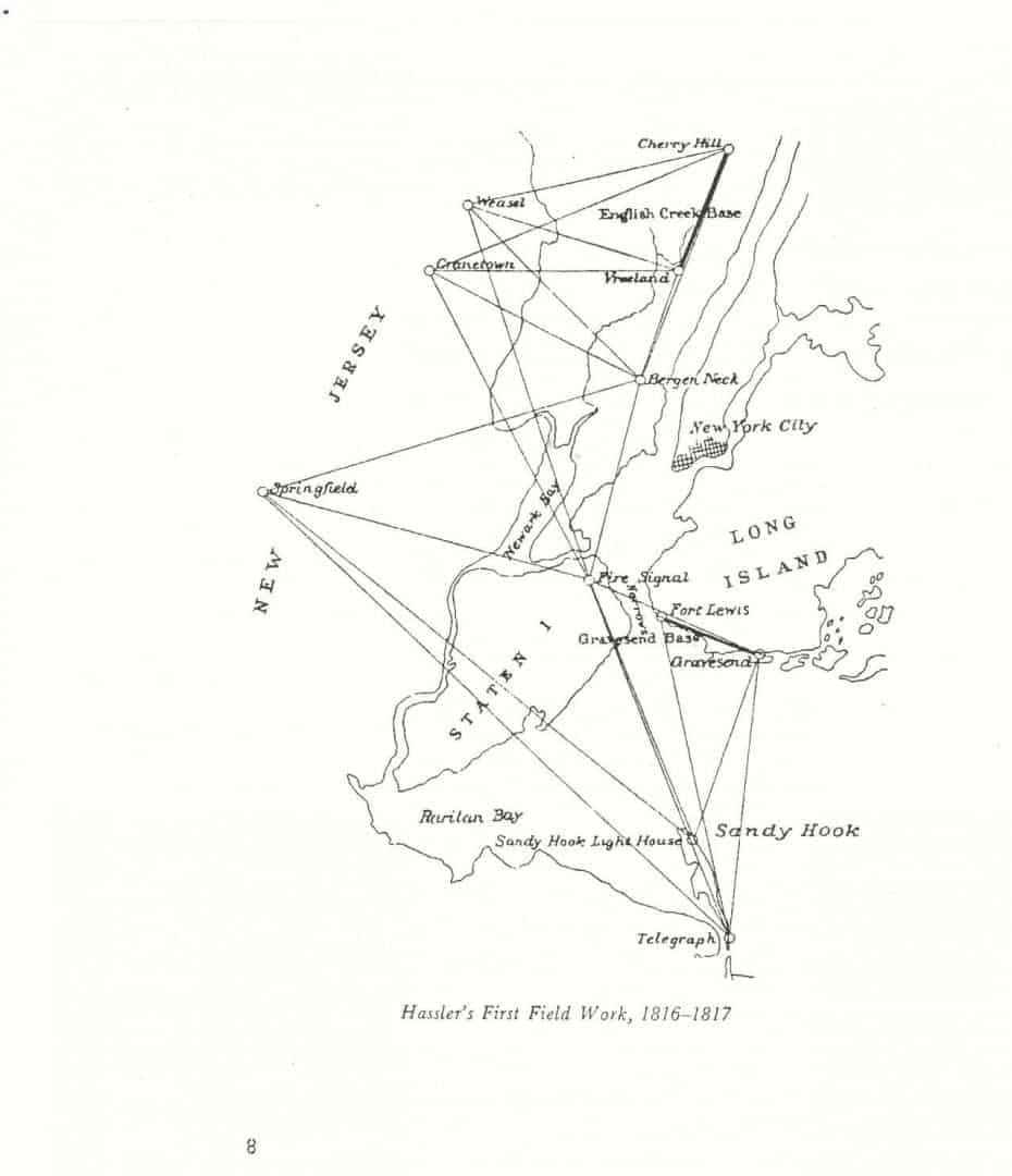
A few years ago, I was reading about Hassler and the original triangulation of NYC area. One of his stations ÛÏWeaselÛ was less than a 1/4 mile where I would romp with friends atop the mountain. There was a small pond where we could dip in the summer and skate in the winter and have a cookout among the rocks.
The station that Hassler set was a drill hole in rock filled with sulphur. Weasel was the first triangulation station set in America by Hassler
From this station, they observed the Buttermilk station and another at Sandy Hook near NY harbor. I read that the observations were taken in the night. Bonfires were lighted atop the stations for the observations. Sort of primitive heliotrope.
I think the mark is still in the NGS db. But it was destroyed, because this area became a major quarry for the NYC area for decades and maybe centuries. It was a quarry when I was a teen. I think it has been quarried out and is a S/D now.
Here is a view from the area of the first US tri-station Weasel viewing the NYC skyline. 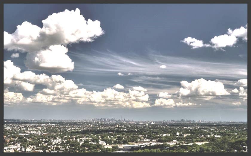 .
.
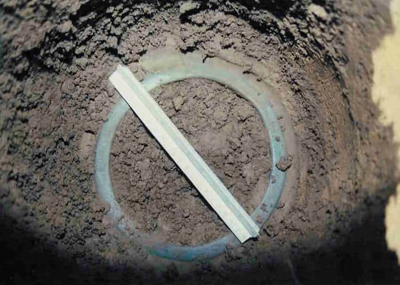
That is a "cone". Not sure exactly what they look like other than the top. Here is a description from another nearby station of the same vintage (DISBORO 1839):
KV5314'THE STATION MARK IS A HOLLOW TRUNCATED CONE OF THINLY GLAZED
KV5314'GRAY POTTERY, OF THE DISTINCTIVE TYPE USED BY HASSLER, ABOUT
KV5314'8-1/2 IN OUTSIDE DIAMETER AND 1/2 IN THICK AT THE TOP OR SMALL END,
KV5314'BURIED 18 IN UNDERGROUND IN DENSELY PACKED YELLOW SAND.
In 1983 Wendy Lathrop wrote an article for Professional Surveyor Magazine about their recovery of the station DISBORO (without GPS).
http://www.cadcon.com/pdf/Disboro_PS.pdf
Here is a better write-up by Wendy.
http://www.cadcon.com/pdf/Disboro_SM.pdf
The inside diameter is about 6.75". That is a broken scale. The only way to center over it is to estimate the center. I called an NGS advisor the time, and asked him how to determine the center. He pretty much freaked out and was yelling at me not to disturb it, who gave me permission, etc. I later found out he was mad because he had been looking for that particular station for years, but the description was not good enough to recover it. So, I just covered it back up and reported "recovered as described".
If I recall correctly, we put a rebar at the surface over the center of the cone.
A Hassler cone!
Now that is cool!
John Hamilton, post: 386437, member: 640 wrote: That is a "cone". Not sure exactly what they look like other than the top. Here is a description from another nearby station of the same vintage (DISBORO 1839):
KV5314'THE STATION MARK IS A HOLLOW TRUNCATED CONE OF THINLY GLAZED
KV5314'GRAY POTTERY, OF THE DISTINCTIVE TYPE USED BY HASSLER, ABOUT
KV5314'8-1/2 IN OUTSIDE DIAMETER AND 1/2 IN THICK AT THE TOP OR SMALL END,
KV5314'BURIED 18 IN UNDERGROUND IN DENSELY PACKED YELLOW SAND.In 1983 Wendy Lathrop wrote an article for Professional Surveyor Magazine about their recovery of the station DISBORO (without GPS).
http://www.cadcon.com/pdf/Disboro_PS.pdf
Here is a better write-up by Wendy.
http://www.cadcon.com/pdf/Disboro_SM.pdfThe inside diameter is about 6.75". That is a broken scale. The only way to center over it is to estimate the center. I called an NGS advisor the time, and asked him how to determine the center. He pretty much freaked out and was yelling at me not to disturb it, who gave me permission, etc. I later found out he was mad because he had been looking for that particular station for years, but the description was not good enough to recover it. So, I just covered it back up and reported "recovered as described".
If I recall correctly, we put a rebar at the surface over the center of the cone.
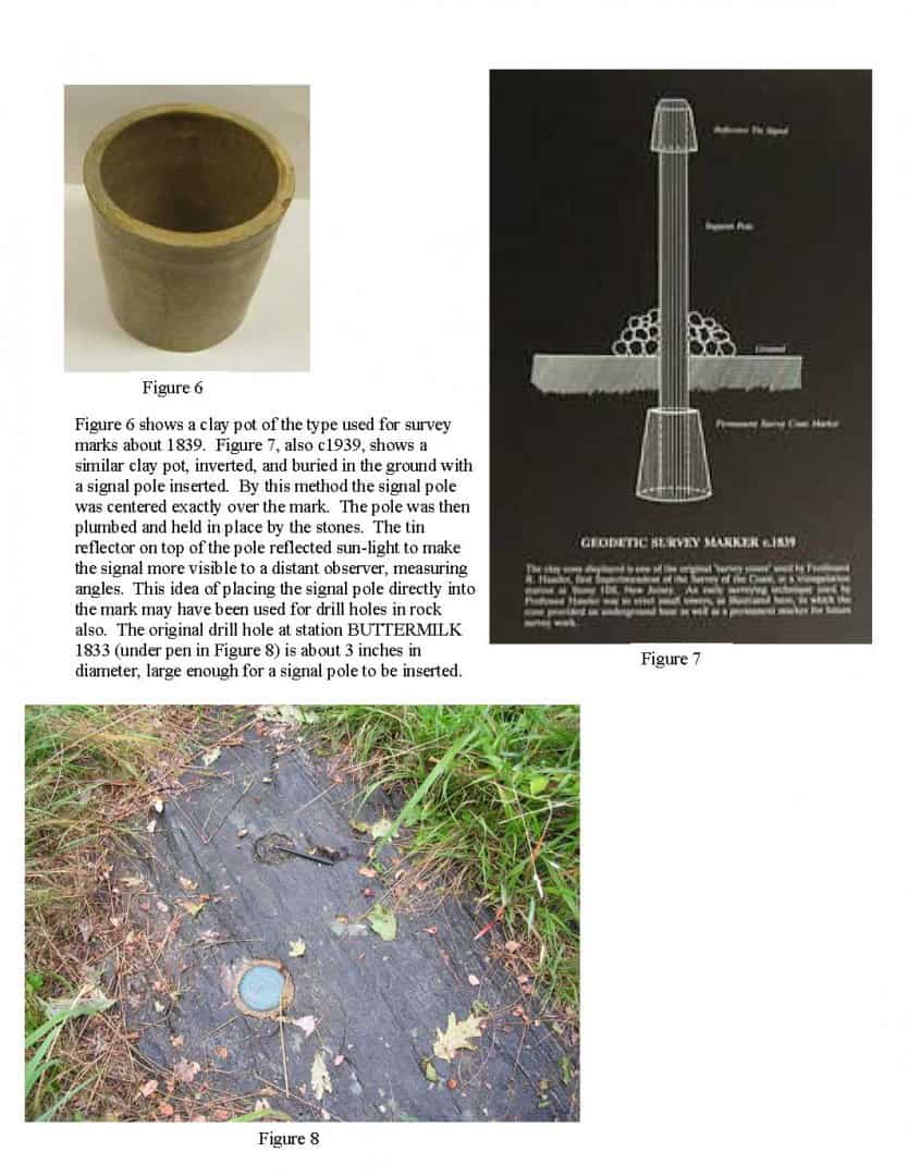
Some info on clay pots and how they were used
Jim Vianna
James: thanks for that info, I had never seen that explanation!
John Hamilton, post: 386457, member: 640 wrote: James: thanks for that info, I had never seen that explanation!
your welcome, the full article can be found here http://www.ngs.noaa.gov/web/about_ngs/history/Survey_Mark_Art.pdf which gives the best historical accounting I have seen to date. Being a little partial to the works of Verplanck Colvin I draw your attention to page 9 of the link.
here is one of the earlier "USGS" marks I have found while on a Colvin Crew recovery deep in the Adirondacks:
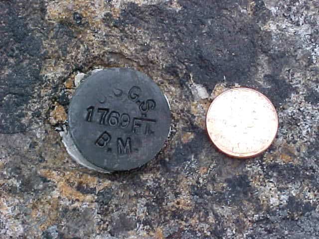 "A rare U.S.G.S. BM found on club property: Set by A. F. Krause in 1896 on a level run between the Indian Lake Bridge and Aiden Lair. It was then recovered in 1942 by S.E. Mitchell running from the Minerva Lodge (near intersection of NorthwoodÛªs Club Rd. and Rt. 28) into the club and then on to the junction of the Indian River with the Hudson. The revised elevation in 1942 was 1,764.972'
Probably the oldest I have seen is this "USCS" is the point called "crown point" on lake Champlain, off the top of my head I guessing a date around 1860's
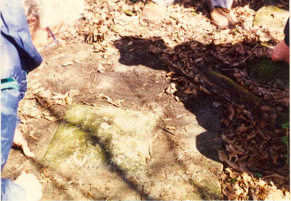
I should add that the picture I show above is described as station "buttermilk" which might be the same one Scott is talking about. Will have to wait for him to verify
Jim Vianna
BM JV3199. Chiseled square in granite window sill in the Hagerstown MD courthouse. Established Oct 1877, USCS. Found as described.
What makes this BM special is its designation. As we've all seen, most BMs have an alpha-numeric designation, like V39, or L266.
This BM is designated: A
Just the letter A.
And as the letter implies it's the first inland BM of the US Coast Survey. From the NGS data sheet:
JV3199' RECOVERY NOTE BY NATIONAL GEODETIC SURVEY 1990 (DW)
JV3199' HISTORIC NOTE. THIS IS THE FIRST BENCH MARK SET BY US COAST SURVEY (LATER US C+GS AND NGS) IN ITS FIRST INLAND ELEVATION SURVEY FROM WASHINGTON TO HAGERSTOWN ALONG THE C+O CANAL
I think that is pretty cool.
John Hamilton, post: 386437, member: 640 wrote: That is a "cone". Not sure exactly what they look like other than the top. Here is a description from another nearby station of the same vintage (DISBORO 1839):
KV5314'THE STATION MARK IS A HOLLOW TRUNCATED CONE OF THINLY GLAZED
KV5314'GRAY POTTERY, OF THE DISTINCTIVE TYPE USED BY HASSLER, ABOUT
KV5314'8-1/2 IN OUTSIDE DIAMETER AND 1/2 IN THICK AT THE TOP OR SMALL END,
KV5314'BURIED 18 IN UNDERGROUND IN DENSELY PACKED YELLOW SAND.In 1983 Wendy Lathrop wrote an article for Professional Surveyor Magazine about their recovery of the station DISBORO (without GPS).
http://www.cadcon.com/pdf/Disboro_PS.pdf
Here is a better write-up by Wendy.
http://www.cadcon.com/pdf/Disboro_SM.pdfThe inside diameter is about 6.75". That is a broken scale. The only way to center over it is to estimate the center. I called an NGS advisor the time, and asked him how to determine the center. He pretty much freaked out and was yelling at me not to disturb it, who gave me permission, etc. I later found out he was mad because he had been looking for that particular station for years, but the description was not good enough to recover it. So, I just covered it back up and reported "recovered as described".
If I recall correctly, we put a rebar at the surface over the center of the cone.
That was a very nice narrative by Ms. Lathrop. It shows the dedicated professionalism of the group preserving history.
She once came to a seminar at Alexandria, LA. At the 'Cochon De Lait' soir̩e on Friday night, she told me that she was having a good time even though she didn't eat pork.
James,
The pen is pointing at Buttermilk and the disk (from memory) is a USGS bench mark.
i guess that I was wrong about my post about the observations at Weasel. I will have to find the book where I read it. but please see my disclaimer at my signature. ; ) I''l have to look round here for the book, but if memory serves me correctly, they observed a station in Yonkers and also at Sandy Hook Light House with long night observations with the bonfires. He probably had a minuscule budget and maybe the sketch below was just a sketch.
Now we find from the testimony of one of Mr Hassler's assistants 41 that we do not know the exact difference of longitude between any point in the survey and the meridian of Greenwich near London from which all our navigators calculate their longitude since they use the Nautical Almanac calculated at that observatory But from Mr Hassler's testimony it appears that he has one perfect astronomical station on Weasel mountain in the interior of the country 23 That the calculations of the triangles will ive in ultimate results the longitude and latitude of every point in the survey cannot be denied But before we arrive at this ultimate result we must have more astronomical observations and his main triangulation carried his secondary triangulation and verified .
https://books.google.com/books/content?id=6DhYAAAAYAAJ&pg=PA12&img=1&zoom=3&hl=en&sig=ACfU3U1F-49bfotTaupTv97C-HOdk9R9kQ&ci=57%2C812%2C899%2C293&edge=0
