Before anyone posts a reply, Please, do not turn this political! Of course everyone knows there has been talk about a more substantial southern barrier. Could this be beneficial for surveyors, or is this entire line already substantially marked? If a barrier were to be placed along the entire length, where would it be placed along the river sections? If placed on the US side of a river, would that cut off access to ranchers who depend upon the water for livestock? Google Earth has some interesting border monument photos if you trace along the line.
If a barrier were to actually be constructed along La Frontera I'm sure its location would be decided more by geographic factors that actually sticking to the actual international boundary as determined by a survey. My uncle farmed the border in cotton for years near Brownsville, Tx. Although his farm was bounded by the Rio Grande River, it was my understanding the river was actually Mexico. Meaning the 'north' edge of the water was considered the border. Someone else might chime in here with more comprehensive info. But his irrigation system pumped water from the Rio Grande. I'm sure it is a complex situation. But from what I've seen, security fences and containment along the border seem to be built more with topography in mind rather than sticking to the "boundary".
As for work for surveyors...get after it, dude. Too damned hot down there for me.
Here in Arizona the border was surveyed with many monuments (over 40 for sure). I always wanted to search for some but caution always got the best
of me. I might ask a friend who works for the sheriff dept. to go with me when he is off duty, he patrols around the border.
JOHN NOLTON
PS the majority of border monuments (from looking at the State of Arizona Triangulation Diagram) look like they are from Nogales, Long 111
west to around Long. 113 +/-
There already have been a lot of land owners on the north side of the border, but south side of the 2006 border fence campaign. A fence without gates. And of course, it isn't on the border for topographical/engineering reasons.
Many of land owners made out on buy out, many got screwed.
A new wall/fence will have 5 decades of law suits over land ownership.
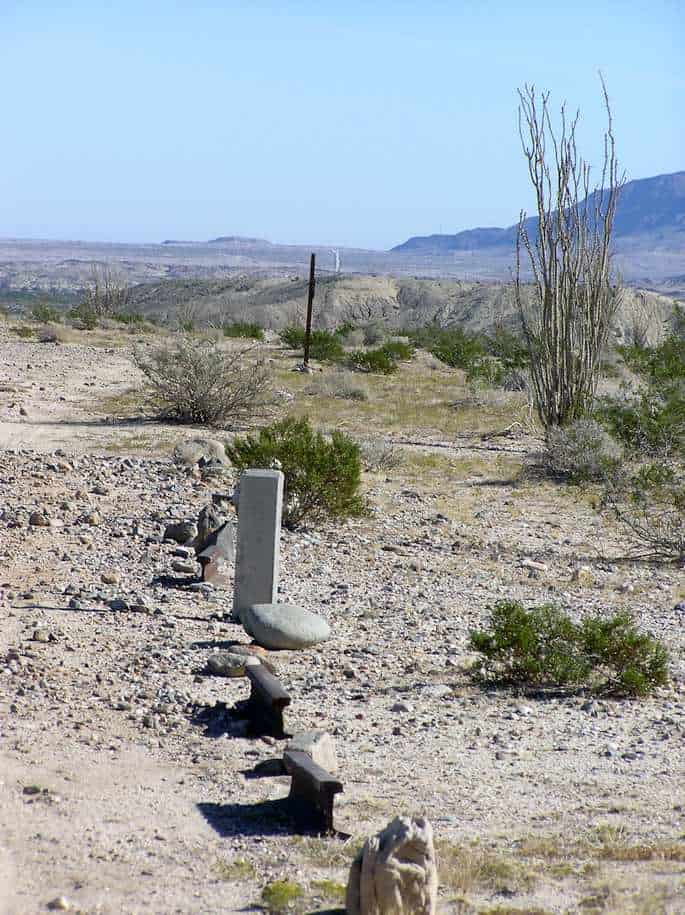
I have done a lot of work on the border of Az. Here is a pic of one of the many monuments we located. This one is east of Yuma.
JOHN NOLTON, post: 372168, member: 225 wrote: Here in Arizona the border was surveyed with many monuments (over 40 for sure). I always wanted to search for some but caution always got the best
of me. I might ask a friend who works for the sheriff dept. to go with me when he is off duty, he patrols around the border.JOHN NOLTON
PS the majority of border monuments (from looking at the State of Arizona Triangulation Diagram) look like they are from Nogales, Long 111
west to around Long. 113 +/-
Erik Myers-nice picture of obelisk. What boundary marker # is it? (or Lat/Long)
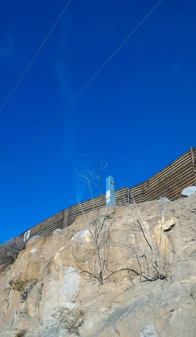
Mike Marks- also a very nice picture. Also what Bdy. Mon. # (or Lat/Long) plus what direction are you looking? (East ?)
JOHN NOLTON
DC2002 #244
+32å¡ 34' 37.02", -116å¡ 37' 12.36"
https://www.google.com/maps/d/viewer?mid=1Ik6S5bhbKoK8lYRTtO6UD3FgrQ8&hl=en_US
Between El Paso and Ft. Hancock TX, we actually used/found two of those (US-Mexico) for the deeded boundary of a tract we were doing for a solar farm.
I laid-out numerous miles of border fence and corresponding border roads. When not dealing with irate land-owners (had some rifles and shot-guns pulled on my) there are various thrown objects that come from the south of the border (mostly rocks, but including flying bales of marijuana). And the joy of having to re-stake every day because your lath disappear nightly - usually by irate land owners or illegal border crossers. Oh yeah, the same irate land owners who remove your control. Nothing like having to get the Border Patrol involved on those issues.
The fence is, primarily, based off of the international border monuments as established by the International Border and Water Commission (dates vary). Those monuments are typically 1 - 2 miles apart depending on terrain in southeast Arizona, from about 6 miles west of Douglas through Nogales and most of the way through the Tohono O'odham Reservation (the T.O. Reservation causes it's own problems for the border).
The fence, for most intents, serves as the border (according to Mexico anyway). For the fencing I laid-out, the fence is supposed to be 2.5' north of the border. I could see how that might vary in places due to terrain, but in Arizona, the idea was to have the fence close to the international border. There was one area where I had to have Border Patrol security (many AR-15s locked and ready) because the fence was over 200' north of the border and we were requested to re-establish the location of the international boundary based on the location of the international monuments - that was a tense few hours being in a grey zone where the Mexican authorities would have had the right to arrest us for trespass although we were technically in the U.S. The Border Patrol really wanted that 200' x approximately .75 miles strip of land back.
I feel bad for most of the land-owners with parcels abutting the international border, they are routinely trespassed upon and their properties are getting trashed. But my sympathy extends to land-owners within 25 miles (it might be larger, I'm a bit rusty on the subject and it's been a long time since I dealt with this stuff) north of the border - the Border Patrol has a blanket easement to do, basically, anything they want on the land in that area. The owners don't have much recourse, although there are numerous land-owners who give the BP a really hard time to do anything involving the BP's activities.
I'm glad I don't do that sort of work any longer. It was very interesting surveying, but the frustration and stress wasn't worth it. My Spanish is bad to put it mildly, other than to get myself in trouble i.e. "uno mas cerveza por favor" = one more beer please. I really don't need to say to another illegal border crosser "Bienvenidos a Estados Unidos, no es la migra, andele andele!" = Welcome to the United States, I'm not the BP, go go!.... They get a confused look, but decide that a guy in a fluorescent orange vest with a 6' metal rod with equipment attached who is gesturing to the north probably isn't going to do anything to them and just wants them to GO AWAY!
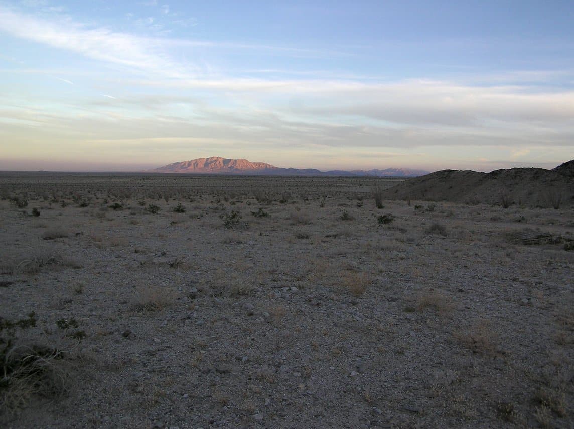
JOHN NOLTON, post: 372342, member: 225 wrote: Mike Marks- also a very nice picture. Also what Bdy. Mon. # (or Lat/Long) plus what direction are you looking? (East ?)
JOHN NOLTON
N32å¡38' W115å¡52' +- looking east. The Yuha Basin in eastern California. Looking south into the basin, the mountain is in Mexico:
J. Penry, post: 372136, member: 321 wrote: Before anyone posts a reply, Please, do not turn this political! Of course everyone knows there has been talk about a more substantial southern barrier. Could this be beneficial for surveyors, or is this entire line already substantially marked? If a barrier were to be placed along the entire length, where would it be placed along the river sections? If placed on the US side of a river, would that cut off access to ranchers who depend upon the water for livestock? Google Earth has some interesting border monument photos if you trace along the line.
For Texas, the line is in the River so the Feds would need an easement or something to place the structure on the private ownership on the North and Northeast side of the river.
Kris Morgan, post: 372485, member: 29 wrote: For Texas, the line is in the River so the Feds would need an easement or something to place the structure on the private ownership on the North and Northeast side of the river.
DHS claims dominion and control for 25 miles on Both sides... so no easement is needed. FYI: DHS is the highest authority.
Peter Ehlert, post: 372529, member: 60 wrote: DHS claims dominion and control for 25 miles on Both sides... so no easement is needed. FYI: DHS is the highest authority.
??? From watching some Border Patrol reality TV series I thought the Border Patrol is banned from crossing into Mexico, even in hot pursuit. Their extraordinary rights extend 100 miles *north* of the border only. To claim dominion of Mexican soil would create an international backlash. (wiki):
"Regulations establishing the 100 mile zone were adopted by the U.S. Department of Justice as the result of an interpretation of the Immigration and Nationality Act in 1953. Customs and Border ProtectionÛªs (CBP) officials have authority for stop and search within this 100 miles (160 km) from any external boundary. This allows for CBP officials to enter private property without a warrant within 25 miles (40 km) of the border as well as the operation of checkpoints."
And that's it; they're not Navy Seals.
Especially in Texas a taking by Homeland Security for a wall or other facilities apparently requires an eminent domain process. The California-Arizona-New Mexico span is mostly desert and mostly still in Federal hands so the wall (and an electronic wall) has been built within a few feet of the border, which has been proven quite effective and not disgruntled landowners. The Texas span is defined by the Rio Grande, creating topographical and legal problems because treaties with Mexico prevent either country from constructing within the river's flood plains, so any rational barrier could be up to a mile or more upland of the river and disenfranchise owners of their riparian rights and property.
The Rio Grande has become the route of choice for wetbacks since the desert crossings to the west have been secured. It's prime because the river is tough country to patrol because of its riparian nature, heavy urbanization, weather. It's the last big hole in the Mexican border and even Donald Trump will have difficulty securing it.
May we as surveyors protect the rights of Texas landowners as this process unfolds.
[USER=1108]@Mike Marks[/USER] ... my statement was based on my numerous conversations with those guys that drive the vehicles with DHS license plates.
I don't watch "Reality TV" shows.
(to be very clear, they are Not labeled as US Government plates, they are DHS pates)
They are all young people, they are Not friendly, they all wear bullet proof vests and carry guns. I do not argue the point with them.
Perhaps over on my end things are different than in Texas.
Hmm. A statement by the CBP concerning the matter (2013):
[INDENT]"U.S. Customs and Border Protection (CBP) respects the sovereignty of the country of Mexico and its territorial integrity. Without the express authorization of the Mexican government, CBP personnel are not authorized to physically cross the international boundary when conducting operations."
[/INDENT]
As an aside, even domestic commercial airline flights do not cross the border. I used to fly frequently from San Diego to Tucson, where a straight line flight would briefly enter into Mexican airspace from Mexicali to Yuma. But looking out the window it was clear we veered north to stay in CONUS, then back south once past Yuma. I finally asked a pilot during the disembarking meet-and-greet and he said "Oh no, if the plane were to enter Mexican airspace the paperwork would be horrendous" and he'd get a black mark on his record. Also said it was kinda silly because we're at 35,000 feet then, hardly a security risk, the incursion would be only a few miles, and the straight line route would save around 10 gallons of fuel.
Just spoke over the phone with my (retired) CA-AZ Border Patrol buddy and he said in no uncertain terms they are barred from crossing into Mexico, even in hot pursuit. He said he'd never done so, and knew of no "wink-wink" rule bending by anyone in the BP. He said it was frustrating in a few cases; if caught very near the border on the US side, the mules would dump their pot loads and hotfoot it back across the border, then have the balls to taunt the BP from the protection of the other side. So they know the rules too.
Andrew Clark, post: 372448, member: 10563 wrote: I laid-out numerous miles of border fence and corresponding border roads. When not dealing with irate land-owners (had some rifles and shot-guns pulled on my) there are various thrown objects that come from the south of the border (mostly rocks, but including flying bales of marijuana). And the joy of having to re-stake every day because your lath disappear nightly - usually by irate land owners or illegal border crossers. Oh yeah, the same irate land owners who remove your control. Nothing like having to get the Border Patrol involved on those issues.
The fence is, primarily, based off of the international border monuments as established by the International Border and Water Commission (dates vary). Those monuments are typically 1 - 2 miles apart depending on terrain in southeast Arizona, from about 6 miles west of Douglas through Nogales and most of the way through the Tohono O'odham Reservation (the T.O. Reservation causes it's own problems for the border).
The fence, for most intents, serves as the border (according to Mexico anyway). For the fencing I laid-out, the fence is supposed to be 2.5' north of the border. I could see how that might vary in places due to terrain, but in Arizona, the idea was to have the fence close to the international border. There was one area where I had to have Border Patrol security (many AR-15s locked and ready) because the fence was over 200' north of the border and we were requested to re-establish the location of the international boundary based on the location of the international monuments - that was a tense few hours being in a grey zone where the Mexican authorities would have had the right to arrest us for trespass although we were technically in the U.S. The Border Patrol really wanted that 200' x approximately .75 miles strip of land back.
I feel bad for most of the land-owners with parcels abutting the international border, they are routinely trespassed upon and their properties are getting trashed. But my sympathy extends to land-owners within 25 miles (it might be larger, I'm a bit rusty on the subject and it's been a long time since I dealt with this stuff) north of the border - the Border Patrol has a blanket easement to do, basically, anything they want on the land in that area. The owners don't have much recourse, although there are numerous land-owners who give the BP a really hard time to do anything involving the BP's activities.
I'm glad I don't do that sort of work any longer. It was very interesting surveying, but the frustration and stress wasn't worth it. My Spanish is bad to put it mildly, other than to get myself in trouble i.e. "uno mas cerveza por favor" = one more beer please. I really don't need to say to another illegal border crosser "Bienvenidos a Estados Unidos, no es la migra, andele andele!" = Welcome to the United States, I'm not the BP, go go!.... They get a confused look, but decide that a guy in a fluorescent orange vest with a 6' metal rod with equipment attached who is gesturing to the north probably isn't going to do anything to them and just wants them to GO AWAY!
"...we were requested to re-establish the location of the international boundary based on the location of the international monuments"
Its been my understanding that this can only be done upon agreement by both Nations. Were you with the BLM at the time?
Many Texas DPS and Game Officers sign up for tours of Border Duty every year and the time spent has given them a new attitude on their regular jobs.
They act very defensive and ready to attack on or off the job.
Those that I know personally are more stressed and on point 24/7.
Jim,
I was working for a private company that was sub-contracted to the BP. I'm not sure if they actually built the fence along the border or where the existing fence was located. I think that the BP wanted to see the location on the ground and probably needed to show what was occurring in that area to the superiors for further advice.


