I had a call last week from a fellow who with some partners had bought about 5,000 acres of West Texas land about twenty-two years ago from a bank that had ended up with about 12,000 acres of which it was a part. Basically, it was all of the 12,000 acres situated on the West side of a State Highway that ran across the larger tract.
In 1994 when I made the survey to locate the 12,000 acres and describe various parts of it that the bank sold to different parties, I did three things that in retrospect were fairly smart. In the first place, I oriented the survey to grid North of the Texas Coordinate System, connected it to control points with published positions in the NGS database, and reduced the survey to derive the coordinates of all of the points positioned by the survey in the Texas Coordinate System.
Since that time, in the course of other projects, I've gone back and have gotten GPS vectors to various control points positioned by the 1994 work. Since the original survey was adjusted in Star*Net, it was light work to readjust the old work to the new GPS-derived positions, discovering in the process how excellent the conventional work had been in 1994.
Now the project is to pick up on the survey made 22 years ago by conventional methods and subdivide the 5,000 acres into "little" tracts of 1,250 acres. I'm looking forward to doing just that since I know from prior work that the original survey was oriented to grid North essentially exactly (from solar observations with a Zeiss Th2, a one-second theodolite) and the crude method I used at the time (scaling elevations from topo sheets) to reduce distances to grid produced results with scale errors of just a couple of ppm.
Very good Kent! Conventional is Good!
Jules J., post: 393465, member: 444 wrote: Very good Kent! Conventional is Good!
The key thing here is that by keeping the 1994 survey "alive" as a Star*Net adjustment, since the original work was good quality, I can simply locate a few more control points from that survey by GPS to readjust the 1994 work and update all of the coordinates to NAD83 at current epoch without needing to resurvey the whole enchilada. The results will be basically as good as could be done today.
It was overkill to survey that tract as well as we did in 1994, although in reality we the quality of the survey is mostly the result of including a number of azimuth observations throughout the project, having a long-range EDM at the time, and using some tricks to improve the network for minimal effort. The benefit, though, is that the work remains more than good enough. I could resurvey it all, but the answer would be essentially the same.
There is an old book of financial advise which says that "a part of all you earn is yours to keep". Meaning that you should save and invest a part of every paycheck.
In a similar vein a book of survey business advise might say "every measurement you make is yours to keep". A measurement made in 1994 is just as good as the day they were made as long as the endpoint monuments, or well connected monuments, remain in place.
Mark Mayer, post: 393482, member: 424 wrote: A measurement made in 1994 is just as good as the day they were made as long as the endpoint monuments, or well connected monuments, remain in place.
Yes, the monuments I set on that project were all punch marks on aluminum-capped rebars in drill holes in rocky ground. The last time I saw some of those markers from 1994 was in 2007 and the aluminum caps remained then in great shape with the stampings clearly legible. The extra cost of setting a reasonably permanent marker is also an investment of sorts.
The traverse points were all 3/8" steel spikes with stamped aluminum washers. So even the control points are readily identifiable.
This little trip down memory lane got me to drag the survey photos out again. At several places on that project, the control point was on a hill where it could be seen from various stations. I left lengths of Schedule 40 PVC pipe guyed in place over the mark on some of them. I can't recall the name of the fellow with the bad hat who looked as if he'd been ordering the Guadalajara Plate a bit too often at the cafe. The target was sighted as an object from five different other control points at distances of 2 to 3 miles.
That ranch fell entirely within a 200-square-mile block of surveys known as MK&TE Railway Co. Block D or D1 that had some features that aren't atypical in West Texas. The block had been originally located in 1881 by virtue of land scrip issued to the MK&TE Railway Co., each certificate of which entitled the railroad company to have 640 acres surveyed out of the unappropriated public domain. The surveys were to be made in the form of a square unless otherwise prevented by prior surveys of adjoining lands and for each section surveyed, the company was to survey the same quantity of land for the State of Texas. This produced a checkerboard pattern across the 200 sections of railroad sections and State sections, the latter having been set aside for the benefit of the Permanent School Fund.
The 1881 surveyor was an Irish Texan named Charles Archer, who later served for years as County Surveyor of Dallas County. As a part of his work in locating Block D or D1, Mr. Archer also located hundreds of other sections as a part of a large series of blocks extending across the South end of what is now Terrell County. Mr. Archer generally had a vast expanse of unappropriated land within which to locate a pile of land scrip issued to various railroad companies.
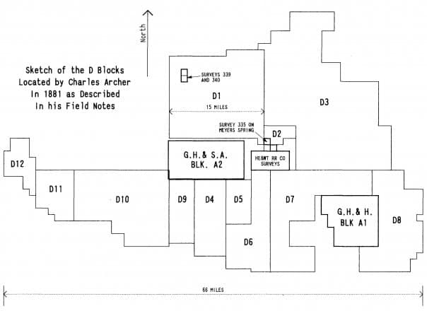
In the sketch below, the prior locations include Survey 335 on Meyers Spring, the two GH&SA Blocks A1 and A2, the block of HE&WT RR Co. Surveys, and the two Surveys inside Block D1, Surveys 339 and 340. The rest of the land was blank paper on the county map.
The MK&TE Rwy Co. had sold the land scrip before having it surveyed, most of it having been purchased by Easterners who expected to make lots of money operating large ranches. That is, they bought great piles scrip to make ranches of tens and hundreds of thousands of acres when the alternate State sections were figured in.
The object of the 1881 survey was to appropriate the land and secure patents confirming title, not to survey and mark every section of the over a thousand located in the course of the work. It would only be later when wells were to be drilled, buildings constructed, and the larger blocks were broken up that anyone would particularly care where the individual sections were.
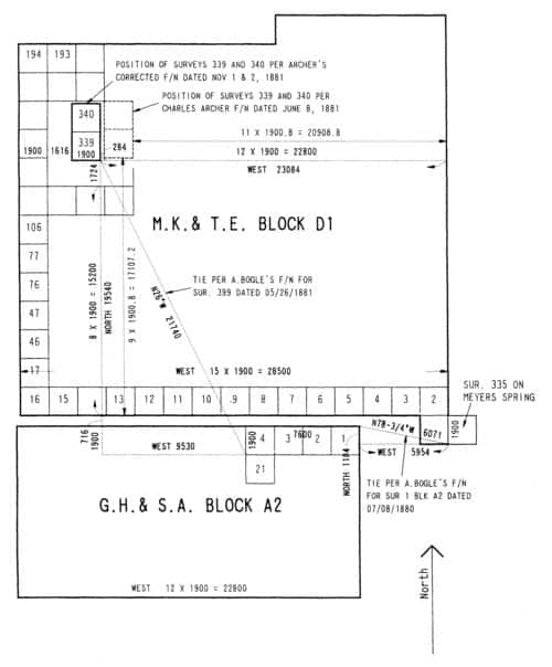
As a result, Mr. Archer's work in locating Block D or D1 consisted at most of only running three sides of the block, with no evidence that he had ever ventured inside that outer boundary in the course of his 1881 survey. This is what the field notes he originally filed in the GLO showed Block D to look like. Mr. Archer filed one set of notes dated June 8, 1881 that were based upon his idea that the two senior surveys 339 and 340 were in the positions indicated by the dashed lines, and later filed corrected notes dated November 1 and 2, 1881 that reworked the surveys surrounding Surs. 339 and 340 as if they were in the positions more than a mile West of where he had earlier thought them to be.
His later corrected field notes were almost certainly based upon office calculations made from the field notes of Surveys 339 and 340 and the ties to a survey in Block A2 that was itself connected to Survey 335 on Meyers Spring. Since Charles Archer had tied his location of Block D1 to a corner of Survey 335, it was possible to sit in the office and calculate where Surveys 339 and 340 "should be" within Block D1 and that plainly is what was done.
What the person who made the calculations upon which the corrected field notes for the sections in Block D surrounding Surveys 339 and 340 ignored, however, was that the various surveys from which he was assembling the series of connecting courses upon which the calculation was based had been run *at different variations*. In other words the "North" direction in reference to which GH&SA Block A2 had been laid out was different from that of Archer's work in Block D1. Surveys 339 and 340 had their own "North" direction as well.
As a result the office calculation for the corrected field notes of November, 1881 was also a flop.
By the way, if you feel somehow that your career as a surveyor won't be complete until you are stung by a large black wasp known as a Tarantula Hawk, returning to PVC pipe targets like the one above without any sort of cover on the open end is a fairly good way to check that item off your bucket list.
Kent McMillan, post: 393567, member: 3 wrote: By the way, if you feel somehow that your career as a surveyor won't be complete until you are stung by a large black wasp known as a Tarantula Hawk, returning to PVC pipe targets like the one above without any sort of cover on the open end is a fairly good way to check that item off your bucket list.
No thanks, I'll leave those critters to you and all the fine inhabitants of West Texas.
I do remember as a small child getting stung on the hand by a scorpion at my auntie's house in Sun City, AZ. I thought my arm was going to fall off...then I wanted someone to cut off my arm. I also remember being sick as a dog. As opposed to that experience, the stinging insects here in OK are a breeze, even the scorpions.
paden cash, post: 393577, member: 20 wrote: No thanks, I'll leave those critters to you and all the fine inhabitants of West Texas.
Well, whoever ordered the wasp population of the Chihuahua Desert end of West Texas doubled the specification for venom strength and stinger length. In Oklahoma, you can settle for fire ants and any junk yard bees flying around, but we don't do things halfway in Texas. The Tarantula Hawk reputedly has second most painful sting of any insect anywhere on the planet.
Kent McMillan, post: 393582, member: 3 wrote: ...The Tarantula Hawk reputedly has second most painful sting of any insect anywhere on the planet.
C'mon Kent, don't leave us hanging. I bet there's at least three or four folks here that want to hear exactly how painful it was for you...;)
Well, he got me on the ring finger and before I could get my ring off, the finger inside it had swollen like the Pecos River in flood. The event was not unlike realizing that one has just brought a hammer down on his finger full force. The sight arrives before the sensation. It began slowly and built to a torrent of pain from angry nerve endings. working up my arm as I realized that while I had a pair of bolt cutters in the truck, there was no way to get them in to actually cut the ring. After about half an hour, the pain settled in to feeling like just a couple of yellow jacket stings and we were able to get back to work, although my writing in the field book may have been no great marvel of craftsmanship until much later that day.
Kent McMillan, post: 393601, member: 3 wrote: ... working up my arm as I realized that while I had a pair of bolt cutters in the truck, there was no way to get them in to actually cut the ring...
Yeppers, trying to operate even a small pair of bolt cutters one-handed would have surely earned you a merit badge. I googled your dreaded Tarantula Hawk and am sure happy we don't see many up here. Hopefully you had some 'snake bite' medicine in the truck to calm the nerves...;)
Oh, and I forgot to mention that when the pain of the sting worked its way up my arm from my finger and hit my shoulder, it occurred to me that this wasn't any ordinary wasp. We were about fifteen minutes from the highway and about an hour or more from the nearest hospital.
Fortunately, that which doesn't kill you can make you stronger.
You lost me at "12,000 acres". I admit I would have no clue how to survey that. I just gave a proposal out on 15 acres and said to myself 'wow,that'ss a big survey'.
Joe the Surveyor, post: 393616, member: 118 wrote: I admit I would have no clue how to survey that.
Not much of a secret. The tract was described as consisting of 20 sections to which the State of Texas had issued patents based upon the survey made in 1881 by Charles Archer, the Irishman who was later County Surveyor of Dallas County. Those in turn were surrounded by the remaining 200 sections in the entire block of surveys located by Mr. Archer at the same time.
The first question was "What did Charles Archer actually survey and what did he merely draw up on paper in the course of locating the 200 sections, including those comprising the subject ranch?"
After that, the next question dealt with the history of private ownership following the land leaving the public domain. That happened in 1900 as I recall.
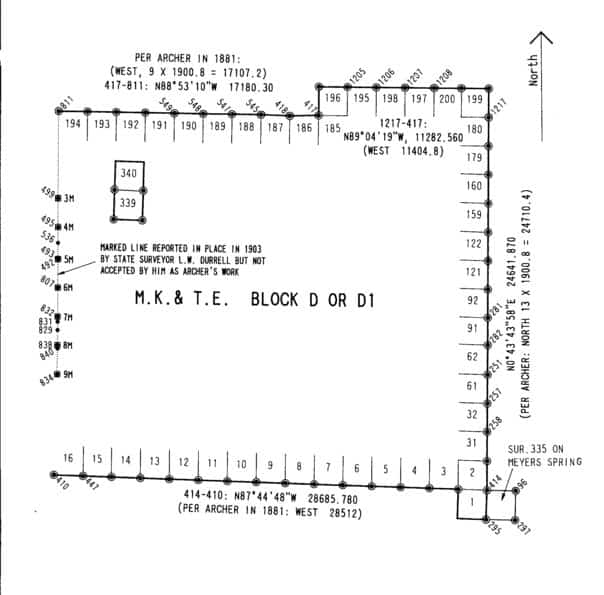
The line with the mounds marked "3M" through "9M" (3 Miles through 9 Miles from the NW block corner) was a line that had been surveyed prior to 1902 (Block D was originally surveyed in 1881), but fairly clearly as a trial line along a side of the block that had not originally been closed. The mounds I found marking the miles were small and unlike the fairly substantial mounds that the evidence indicates that Archer did build along the East and North lines of the block. I concluded that the mounds on the West line of Block D had probably been built in 1899 or 1900 in connection with a subdivision of Block D into large pieces.


