http://freepdfhosting.com/c72dfd97cf.pdf
That link is to a PDF of the occupation survey that I did in Old Town Pasadena. It turned out suprisingly well and agreed, for the most part, of doing an establishment just using the city control.
I dont know why, but I really like the name of that subdivsion.
PAUL,nice map, but does LA County not require a North arrow?
Nice map, as is usual for you. I wish I could get that level of detail from my colleagues around here.
I saw your basis of bearings statement, but didn’t notice the lack of an arrow until mentioned by ACD Surveyor.
Nice work.
Well done Paul. I was curious as to the lineweight you have on the adjoiners from your SE and SW corners; is there a reason those are as heavy as your boundary?
MAYBE COZ YOU WOULD LIKE TO BE A
"GOOD ONE"
WHEN YOU GROW UP.
DON'T THEY HAVE ANY IN TEXAS???
CHEERS
GEEZER
Nice job Paul...
I appreciate the willingness to post, especially when utilizing both monuments and occupation evidence.
Are your bearings/distances measured values? What about the corresponding RECORD values (usually illustrated within parentheses).
Geezer, iz dad you?
As in GeezBrgr?
N
Mr. Date
I've asked Paul about that before. That's second nature to us up here, but apparently not down South.
what's up Jerry! I mean Geezer..
Mr. Date
Record data is required info in Oregon...
Record v. measured
> I've asked Paul about that before. That's second nature to us up here, but apparently not down South.
It is really a county to county thing down here. I know LA County does not make a stink about R v. M. Orange, Riverside, San Bernardino prefer it and want it shown if there is record dimensions.
Record v. measured
Showing record info, ties the history to the present. And depicts and illustrates the harmony or discrepancies, thus allowing future followers of the ROS, to better see the justification of the boundary determination...
> PAUL,nice map, but does LA County not require a North arrow?
haha...That they do 🙂
Thnx!!
> .... I was curious as to the lineweight you have on the adjoiners from your SE and SW corners; is there a reason those are as heavy as your boundary?
Glenn..Thnx! I need to change some colors so the line along the R/W will not print as wide along the south. I love peer review 😛
I do the boundary lines at 0.7mm width, but I also was showing an inside building wall around the S, W and E sides. That may cause it to look real thick.
> Are your bearings/distances measured values? What about the corresponding RECORD values (usually illustrated within parentheses).
My personal feeling is that any survey represents the surveyors measured values unless it is noted otherwise. I also feel that adding many different record values detracts from the readability of a map. Some Ventura County maps have more than 8 record references for each line..It's just a joke.
LA County does not require it, nor does the state. In fact, I was reading about an accusation on the boards site the other day against a very respectable and seasoned surveyor and one of the idiotic and ridiculous charges was the surveyor did not have any record data on the CR. Now, this guy is 86 years old and still going strong. He has never been disciplined by the board before, and the attorney is nit picking over such trivial matters which most assuredly was provided to him by a proration LS who reviewed the CR.
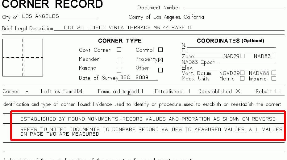
Anyway, just this morning I added a new notation to my CR sheet and will start doing it on my RS from now on..
Here is a snapshot of the new CR/RS note..

A record/measured comparison is done by the signing surveyor, I see no reason what so ever to clutter up a map with both. No doubt this practice was started by someone who had little practical experience or a frustrated angry map checker.
I agree it clutters the map sometimes to the point of absurdity. There are blocks I've worked in where there are at least eight different recorded measurements of the same line some within a couple of hundredths and a couple of seconds of each other. Then, there's disagreement with the description of a found monument; was it a 3/4" pipe, a 1" pipe, an IP, a pin, etc.? I used to dutifully stack every dang recorded measurement on top of my measured b&d but now I narrow it down to ones that are actually pertinent to the survey I'm doing and the CS doesn't ask me what about the others. It's up to us what we show anyway, it's just customary here to show previous opinions in parentheses and to a certain extent, I think it's helpful. Especially, the original dimensions of the lots and blocks on which proration is based.
Steven
Depending on the survey I will show record along a measured line if I feel that it adds to the survey.
I would not do it just because it's the local brew though and my maps would still get recorded.
Steven
How about telling us the final invoice for the job. Not precisely. Maybe to the nearest $500.
Steven
Oh, excuse me, I thought I was being paged.


